Article

A Prospective Study for the Mitigation of the Climate Change Effects: The Case of the North Aegean Region of Greece

by
Ioannis Chatziioannou
1,*,
Efthimios Bakogiannis
2,
Charalampos Kyriakidis
2 and
Luis Alvarez-Icaza
1
1
Instituto de Ingeniería, Universidad Nacional Autónoma de México, México D.F. 04510, Mexico
2
Department of Geography and Regional Planning, School of Rural and Surveying Engineering, National Technical University of Athens, 15780 Athens, Greece
*
Author to whom correspondence should be addressed.
Sustainability 2020, 12(24), 10420; https://0-doi-org.brum.beds.ac.uk/10.3390/su122410420
Submission received: 13 November 2020 / Revised: 3 December 2020 / Accepted: 8 December 2020 / Published: 13 December 2020

Abstract

:
One of the biggest challenges of our time is climate change. Every day, at different places of the world, the planet sends alarming messages about the enormous transformations it is experiencing due to human-based activities. The latter are responsible for changing weather patterns that threaten food production, energy production and energy consumption, the desertification of land, the displacement of people and animals because of food and water shortages due to the reductions in rainfall, natural disasters and rising sea levels. The effects of climate change affect us all, and if drastic measures are not considered in a timely manner, it will be more difficult and costly to adapt to the aforementioned effects in the future. Considering this context, the aim of this work is to implement a prospective study/structural analysis to the identified sectors of a regional plan of adaptation to climate change so as to promote the resilience of the region against the negative phenomena generated by the climate crisis. This was achieved in two steps: first, we identified the relationships between the strategic sectors of the plan and organized them in order of importance. Second, we assessed the effectiveness of several public policies oriented towards a city’s resilience according to their impact upon the strategic sectors of the plan and the co-benefits generated by their implementation for society. The results highlight that the most essential sectors for the mitigation of climate change are flood risk management, built environment, forest ecosystem management, human health, tourism and rise in sea level. As a consequence, the most important measures for the resilience of the North Aegean Region against climate change are the ones related to the preparation of strategic master plans for flood protection projects.

1. Introduction

Nowadays, global warming due to climate change is an undeniable phenomenon, and it has been exacerbating since the 1950s and 1960s due to an augmentation in human-based activities [1,2,3] that generate elevated concentrations of greenhouse gases (GHG). The latter has the capacity to create the warming of the oceans and atmosphere, the melting of ice, and, as a consequence, the rise in the level of waters. Climate change is capable of affecting several sectors, such as human health, water resources, the biodiversity of ecosystems, and agriculture, as well as infrastructure, energy, and transportation. Hence, it is worth mentioning that climate change poses a menace for sustainable development because of its capacity to impact economic development, social well-being, and ecosystems’ security [4].
This situation makes the development of an integral risk management approach of paramount importance as a key pillar in cities whose territorial expansion is driven by an anarchic way to the outskirts [5]. Consequently, more space for the movement of vehicles is required, sustainable mobility is applied improperly and planning strategy is not focused on environmental protection, although during the second part of the 20th century, this planning direction was gaining ground against the comprehensive planning perspective [6]. Nonetheless, formally established housing projects are encouraged by progressive governments, demand state assistance and are based upon the principle of commercialization [7], disregarding the effect of the extension of cities in natural environments, which has been underlined in Habitat I and II Conferences [8].
The modification of land use and the associated destruction of natural resources are “justified” by a major availability of real estate development, new sources of investment and the creation of employments. Along with this, it must also be taken into consideration the factor of irregular human settlements, which are mainly isolated in a city’s outskirts, that negatively impact the environment and, because of the lack of basic public services, increase their vulnerability to climate change [9].
This situation heavily affects the resilience of a city, making it vulnerable to catastrophes. It should be noted that what transforms a natural event into a catastrophe is the level of a city’s vulnerability. That is the capacity of a community or a geographic region to adjust to the negative impacts of an event to which it is exposed [10]. Nowadays, almost 70% of disasters are interlinked with climate change; the aforementioned percentage is the double from the one 20 years ago [11].
As a result of the strong relationship between the vulnerability of a city due to natural phenomena and environmental, economic and social factors, governments are obliged to adopt integral strategies oriented to land management [12], both from an urban and an ecological point of view. According to Evans [13], such strategies may be based on 11 specific principles, the achievement of which may contribute to approaching the resilient city/region model. Such an approach is in compliance with the agenda of the United Nations concerning sustainable development and the creation of inclusive, safe, sustainable and resilient cities.
Holistic approaches of the interlinks between urban policies, climate deregulation and institutional cooperation are a tough situation to solve in order to combine the components of social sciences and natural sciences. The large number of factors/agents involved within the climate risk assessment process, the multiplicity of environmental programmes, the differences between several financing schemes for the study and mitigation of climate deregulation and the large number of laws and norms for the environment’s conservation and protection define a highly complicated context that requires comprehensive approaches [14], from the stage of problem planning until the stage of solutions implementation.
Considering these facts, the North Aegean region of Greece has decided to promote the elaboration of the Regional Plan of Adaptation to Climate Change. The objective of the aforementioned plan is the promotion and implementation of appropriate actions in order to achieve adaptation of the region’s vulnerable sectors to the effects of climate change. Consequently, the motivation of the present study is compatible with the contemporary challenge shared by urban design and urban planning systems, which is closely related to the promotion of cities resilience through a qualitative improvement based on the adjustment of cities to climate change and the negative impacts generated by it.
The aim of this work is to implement a prospective study which is based on the structural analysis method regarding the identified sectors of the North Aegean Regional Plan of Adaptation to Climate Change in order for the degree of resilience to be increased at a regional scale. This was achieved in two steps: First, we identified the relationships between the strategic sectors of the plan and organized them in order of importance. Second, we assessed the effectiveness of several public policies oriented towards city resilience according to their impact on the strategic sectors of the plan and the co-benefits generated by their implementation for society.
The principal research topic for the present investigation is: “How is the organization of the strategic sectors of a regional plan for adaptation to climate change, through a prospective analysis, able to assist in the establishment of a region’s resilience?” The aforementioned main research issue can be translated into four sub-questions: (a) What are the most important elements that need to be considered for the resilience of the North Aegean Region of Greece? (b) Which public measures are associated to the resilience of the North Aegean Region? (c) How are the most critical elements for the establishment of resilience in the North Aegean Region interconnected with each other? (d) Can public policies be formulated in order of importance based on their effect on the plan’s most important components?

2. Background of the Study and Theoretical Framework

In this part of the paper, the reader has the opportunity to be familiarized with some of the study’s basic components. Namely, the geographical, legislative and methodological elements of the study can be appreciated in the following lines.

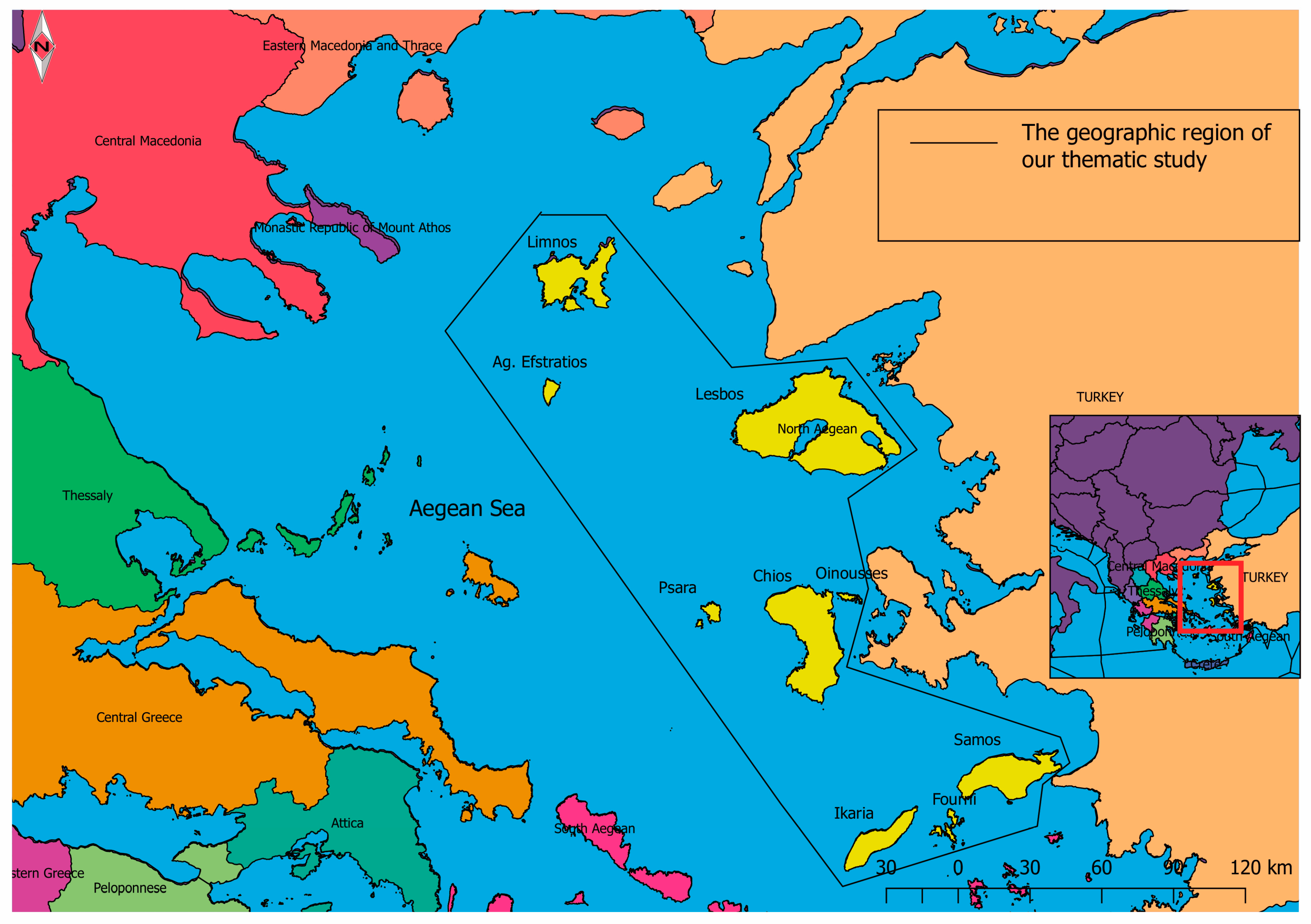
2.1. Geographic Region of the Plan

The Regional Plan for the Adaptation to Climate Change in the North Aegean region focuses on the entire North Aegean Region (NAR). The NAR is an island region with a total area of 3836 km2, covering 2.9% of total area of the country, and is part of the wider geographical unit of the Aegean Archipelago. The region includes five regional units (RU) (Lesbos, Limnos, Chios, Samos and Ikaria), administratively covers the north-eastern quarter of the Aegean Sea and consists of ten inhabited islands—Limnos, Lesbos, Chios, Samos, Ikaria, Aghios Efstratios, Oinousses, Psara, Fourni and Thymaina—as well as other smaller uninhabited islands and a large number of rocky islets. The islands of the North Aegean Region are at the border of Greece with Turkey and most of them are located along the coasts of Minor Asia (Figure 1).
However, it should be noted that the landscape, land uses and coastline complexity vary significantly from island to island. The island of Lesbos is located in the north-eastern Aegean Sea and has an area of 1.637 km2 and a coastline of 381 km. Lesbos is the third-largest island of Greece (behind Crete and Euboea) and the seventh-largest within the Mediterranean Region. The highest mountains of Lesbos are Lepetymnosi in the north-east part of the island, with an altitude of 968 m, and Olympus in south, with an altitude of 967 m. Its main gulfs are those of Kalloni and Gera and are crossed by the streams of Sedounta, Kalamiaris, Evergetoulas, Kavouropotamos and Vouvaris, among others. The most important plains of Lesbos are Kalloni, Evergetoula and Gera, which are the main plains of the gulfs of Kalloni and Gera. There are other smaller plains in torrent valleys, such as Eressos, Molyvos, Polichnitos and Petra. The main rivers of Lesbos are mainly of periodic flow that pass through various plains, such as Evergetoula, Tsiknias, Voulgaris, Almyropotamos, Mylopotamos, Vourkos, Sedountas, the Potamia, Makaras, Tapsas and Tsichliotas (Meladia) [15]. Its distinctive terrain consists of a combination of seashore, mountainous regions and highlands, which, along with the geodiversity and the tectonic nature of the island, the moderate Mediterranean climate, the wide range of ecosystems and the constant human influence on the environment since the ancient years, define the island’s physical and human geography [16].
Limnos has an area of approximately 477 km2 and its coastline length is 264 km. It is predominantly plain, especially in its central and eastern parts, where its arable land is also concentrated. It is the eighth-largest Greek island. Its relief is mild and consists mainly of small volcanic hills, of which the higher, at the north-west end, has a height of 470 m (Skopia), between which plains and small valleys can be observed. Moreover, it has two large bays, Moudros at the south coast and Pournias at the north. In Limnos, the lakes Aliki and Chortarolimni can be found, which are shallow, and the latter dries up during the summer months. Their waters are salty because, in the past, they used to be lagoons. Due to the geological composition of the rocks and the low relief, they are not observed steep slopes. The main rivers of Limnos are mainly of periodic flow that pass through the plains of the island, such as Ragavas, Avlonas and Chandias [15].
The island of Agios Efstratios belongs to the group of islands of the northern Aegean and its area is about 42 km2, with a coastline length of 36 km. Agios Efstratios is geographically isolated and is 17 nautical miles away from Limnos. Its soil is semi-mountainous and volcanic and it has a strong relief with steep shores and is crossed by a large number of hilly complexes and many watercourses inserted between the hills. The highest peaks of the aforementioned hilly complexes are the “Isomata” (292 m), Lemoni Rachi (298 m), Hotzas (298 m) and “Simadi” (288 m). Around the island, there are many small islands and islets, of which the most important are Daskalio at the east, Velia and the Dodeka Apostoloi. The steep shores occupy most of the east coastline, and only to the northern part of the island is there a sloping plain, in the area of Alonitsi. Between the hills, on the west side of the island, small valleys are formed that end in sandy shores, while the rest appear relatively steep [15].
The island of Chios is the fifth-largest island in Greece and its area is approximately 844 km2, with a coastline length of 227 km. Chios is semi-mountainous, with most of it extending to an altitude of 400 m, while the fertile land reaches 18% of the total area of the island. Based on its morphology, Chios can be divided into a northern mountainous zone, a central and an eastern part, which is plain with extensive crops, and the south-eastern part, which is hilly. It is characterized by mainly steep terrain in the northern part that is levelled with lower-altitude hills in its southern part. Its highest peak is Mount Pelinaio (1297 m) at the northern end. At the south of Pelinaio, Oros (1126 m) can be found, and then Koklias (770 m), Provatas (807 m) and Lepro (650 m). There are some even lower mountains with a height ranging between 400 and 600 m, such as Aipos, Kentavros and Koloumpa. The plains of Chios can be found at its coastal lowland areas of the cities of Chios and Kalamoti. The first can be appreciated in the centre of the east side and the second in the south-east part of the island. The rivers are generally small in length, and the main ones are Halikias, Malaggiotis, Elindas, Karteros, Kokkalas, Parthenis and Argenis. In Chios, there are no lakes, except from small shallows lakes and wetlands [15].
Oinousses belongs to the group of eastern islands of north-eastern Aegean, with an area of 14.4 km2 and a coastline perimeter of approximately 35 km. It is a lowland-hilly island with its highest peak located in the central part of the island at 177 m. The Oinousses complex is located between Chios and the south-west coast of the Karabournou peninsula in Asia Minor (Turkey). It consists of nine islets, which are Oinoussa, Prassonisi, Apiganos, Farmakero, Gavathi, Archontonisos, Pontikonisos, Avloni and Valtos [15].
Psara is located in the complex of the eastern islands of north-eastern Aegean, its area is 42 km2 and the perimeter of its coastline is approximately 36 km. It is a semi-mountainous island (hilly) with its highest peak located in its northern part (Profitis Ilias, 531 m). Psara is stony and barren, with its higher peaks being Profitis Ilias and Pithari [15].
The island of Samos belongs administratively to the Prefecture of Samos, with an area of approximately 479 km2 and the length of its coastline equal to 164 km. Samos is mainly mountainous, with the highest peak being Mount Kerketeas at 1417 m in the western part of the island. The lowlands of the island are located in the south-east section (Pythagorion and Vatheos) and in the north-east (Municipality of Karlovasi) [15].
Ikaria has an area of about 254.6 km2, with a coastline perimeter of about 100 km. The main feature of the morphology of Ikaria is the elongated sigmoidal shape, as well as the variability of the relief, where, in the northern part, it is smooth with deep grooves, and in the south, it is steep, due to the development of large morphological slopes with the mountain range of Ether (1070 m) crossing the island along its entire length. Throughout the island prevails the Athera mountain range, with its highest peaks Fardi (1042 m), Melissa (1031 m), Eryfi (1026 m) and Ypsonas (697 m). There are virtually no plains in the island, except from some valleys formed by the torrents of Chalkia and Kampos [15].
The little islands of Agridio, Alatsonisi, Andron, Kedro, Katergakia, Makronisi, Monos and Plaka also belong to Ikaria.
Fourni and Thymaina belong to a cluster of islands, along with Fymenonisi, Alafonisi, Diapori, Strongylo and Agios Minas. They have a total area of 45.2 km2. The largest of these, which are also inhabited, are Fourni and Thymaina. The archipelago has an area of 31 km2, a coastline length of 73 km and is generally diverse with consecutive bays [15].
The islands of Lesbos, Chios, Samos, Limnos and Ikaria belong to the category of large islands, especially compared to the size of the rest of the Aegean islands. On the other hand, the islands Agios Efstratios, Oinousses, Psara and Fourni Thymaina are small islands, while Lesbos and Chios are among the most important islands at the European level. The NAR also includes many smaller, uninhabited islands and multiple islets. The five previously mentioned large islands are located in a relatively remote location among them, while several small islands, such as Oinousses, Psara and rocky islets, depend on them. The NAR has 1335 km of coast, of which 79 km is sandy and only 36 km can finally be considered usable. Overall, the region has limited resources of this category, which is also an inhibitory factor of mass tourism development. However, the most important geographical feature of the NAR is its dual “regionality”, as it represents an outlying region on the eastern border of the country and, at the same time, defines the remote European Union region at its external borders. The spatial dispersion of the islands and the long distances both from each other and from Greece’s mainland cause natural isolation and difficulties in order for the islands to be integrated into transport and other networks [15].
The actual population (2011 census) of the NAR amounts to 198,894 inhabitants (1.8% of the country’s total population). Based on the age composition of the population, the region shows a high percentage (22%) of elderly people (over 64 years), while this perspective at a national level is slightly lower (21.3%). This percentage places Greece as the country within European Union with the second-oldest population, only behind Italy [17]. These facts highlight the necessity for governmental agents within the NAR geographic area to plan and apply countermeasures so as to reduce the impact of climate change upon the elderly vulnerable group, who, due to their condition, are extremely vulnerable against the phenomena caused by climate change (such as extreme weather effects, poor air quality, extreme heat, illnesses spread by mosquitoes and contaminated water) [18]. According to Eurostat data for the period 2001–2012, employment in the NAR followed an upward course with small fluctuations until 2010 and, from there on, recorded a sharp decline of 4.1% in 2011 when the employment rate reached a percentage equal to 55.2%, while the respective rate at the country level was slightly higher (55.6%) [15].

2.2. Legislative Framework and the Nature of the Plan

The effects of climate change are becoming more pronounced both in Europe and globally as time goes by. Regardless of global warming scenarios and climate change mitigation efforts by reducing the emissions of GHGs, the only strategic option, at a national and regional level, is to take adaptation measures in order to address the inevitable effects of climate change and the associated economic, environmental and social costs. Each country, therefore, must include national priorities in the existing and forthcoming climate change measures and contribute to the international effort to reduce GHG emissions. At the same time, each country must be fortified accordingly and in a timely manner against the “residual” effects of climate change so as to mitigate the unavoidable negative impact. Mitigation policies oriented towards the neutralization of the damage from the “residual” effects of climate change are described in general by the name “climate adaptation” or “adaptation policy”. Consequently, the development of a strategy for adaptation to climate change is, at a national and regional level, an obligation arising from the United Nations Framework Convention on Climate Change [19], the EU commitments and the Paris Agreement on Climate Change. In April 2016, the Ministry of Environment and Energy of Greece completed the National Strategy for Adaptation in Climate Change (ESPKA in Greek) and was enacted by Law 4414/2016 [15].
According to article 43 of the aforementioned Law (4414/2016), regions are obliged to develop a Regional Climate Change Adaptation Plan (PESPKA in Greek). The PESPKA is a comprehensive plan that identifies and prioritizes the necessary measures and adaptation lines of action and, in accordance with Regulation 1303/2013 of the EU, shows the guidelines for the implementation of the programs related to the National Strategic Reference Framework (ESPA). The plan has a spatial reference and, thus, it fills in and specializes the initial planning directions proposed by the existing Regional Frameworks of Spatial Planning and Sustainable Development that have initially been institutionalized by the Law 2742/1999 [15].
The purpose of the PESPKA is to reduce the vulnerability of each region in terms of climate change effects. To do this, several changes expected to occur in the coming decades are evaluated and understood, along with various assessments of the risks involved for the environment, society and the economy. The PESPKA must recognize and prioritize the risk-based adjustment options and assess the necessary measures that need to be considered, along with their timetable and costs, at least at a strategic level, as climate change, on the one hand, cannot be accurately predicted and, on the other hand, is a planning process of decades [15].
The aim of this strategy is to help, create and strengthen the region’s infrastructures that will be called upon to tackle the issue of climate crisis, to develop a system for monitoring the problem and its development as well as its possible revision for future program adjustments. With the elaboration of PESPKA, its vulnerable sectors are highlighted and implementation measures are being considered so as to help the region to adapt to climate change [15].

2.3. Introduction to Structural Analysis

The constant need for the people to know what the future reserves for us gave birth to the branch of science called prospective studies, whose principal assumption is that the future is a result of human activities and, therefore, does not happen by its own nature. Hence, the prospective approach has become a fundamental planning scheme which not only permits a close interpretation of the future but also reveals the human actions that may lead to its accomplishment.
Structural analysis is one of the most famous instruments of prospective studies and was applied by Jay Forrester in 1961 so as to understand the behaviour of urban and industrial dynamics. As time passed, the apparatus of structural analysis has been refined through the utilization of diagrams and tables, allowing, in that way, various qualitative and quantitative components to be considered [20].
The method of structural analysis was also implemented by Wanty and Federwish [21] back in 1969, in order to assess multiple industry- and transport-related projects. On their part, Teniere-Buchot applied structural analysis in order to analyse the level of water pollution within the framework of water quality assessment [22]. Over the same period, Kane introduced a structural analysis model which took his name (Kane’s Simulation Model (KSIM)) [23]. In the meantime, Roberts, through the use of structural analysis, provided evidence about the comprehension of interlinks among pollution and energy consumption techniques [24]. Meanwhile, Duperrin and Godet performed prospective studies within the framework of nuclear energy so as to hierarchically organize the most important variables related to that type of energy [25].
In recent days, Sharma and Gupta [26] utilized prospective studies to assess the process of waste recycling. Simultaneously, Arya and Abbasi [27] provided evidence of innovative studies related to environmental review via structural analysis. On their part, Kanungo, Duda and Srinivas applied the tool of structural analysis for the appraisal of the performance of information systems [28]. Furthermore, prospective studies have been blended with international relationships so as to distinguish, describe and comprehend the properties of international conflict [29]. Meanwhile, Qureshi, Kumar and Kumar [30] applied prospective studies for the encouragement and dissemination of Third Party Logistics (3PL) providers main directions. In the last three years, Chatziioannou and Alvarez-Icaza (2017), Chatziioannou, Alvarez-Icaza and Bakogiannis (2020) and Chatziioannou et al. (2020) utilized structural analysis for the management of urban transportation infrastructure, the promotion of integral plans of mobility and the determination of interrelationships between the negative externalities of transport [31,32,33,34].
The structural analysis method is an apparatus designed to interlink ideas. It allows the description of the system under consideration through a table that interrelates all of its components. By specifying and examining the interlinks of the system, the method is capable of highlighting the essential variables for the conduction and improvement of the system.
Structural analysis consists of the three following stages [31,32]:
  • Stage 1: Establishment of the variables inventory.
  • Stage 2: Specification of the variables relations.
  • Stage 3: Recognition of the key variables.
Structural analysis was decided to be utilized because of the subsequent benefits [32,33,35]:
  • It allows the recognition of the critical variables that need to be considered for the system under study.
  • It enables the experts’ judgement to be taken into account within the process of planning.
  • It encourages a profound analysis among the variables of the system.
  • It permits the comparability and the structure of several variables in order of importance.
  • It enables indirect classifications so as to bring to light the importance of several variables that, at first, and through direct classification, were not obvious.

3. Prospective Studies vs. Climate Change: A Study via the Structural Analysis Method

This section reveals the interrelationships between the most important sectors of the North Aegean Plan of Adaptation to Climate Change so as to distinguish the most efficient public policies conforming to the anticipated co-benefits produced by their application. The methodological perspective for this paper can be appreciated in the following lines.

3.1. Stage 1: Establishment of the Variables Inventory

This stage takes into account the production of Table 1, which contains all of the established sectors associated to the system under study in order to enhance the effort of the North Aegean Region of Greece to be resilient against climate change phenomena.

3.2. Stage 2: Specification of the Variables Relations

Stage 2 associates the variables taken into account through a dual-input matrix (Figure 2). The latter exposes at a column level, and through the opinion of experts (Figure 3), the rate of dependence that a variable experiences from the rest of the considered variables. On the other hand, at a row level, the grade of influence that a variable produces upon the other considered variables can be expressed [36]. The typical structural analysis matrix includes values equal to “0” when there is no relation between the variables, “1” when there is a weak relationship, “2” when there is a moderate relationship and “3” when there is a relation of high intensity [20]. Nevertheless, in this paper, for the sake of simplicity, only two values, zero (“0”) and (“1”), will be used so as to highlight the absence and the existence of relations among the variables. In that way, the determination of the interlinks among the variables of the thematic study will be feasible without taking into account the intensity of the relationships. Hence, the reliability of the results seen in the subsequent matrix (Figure 2) in qualitative terms will be intact.
The direct relations matrix appreciated in Figure 2 is the outcome of a consulting process with numerous (fourteen) unrelated and interdisciplinary specialists (interviewed in two groups of seven) that assisted us to distinguish interlinks within variables that, at the beginning, were not evident [31,32]. These sample size and group size choices are in line with the best practice according to literature [22,31,32]. The consulted experts were geographers, transport engineers, urban planners, experts in energy consumption and tourism, environmentalists, civil engineers, mechanical engineers, physicists, mining engineers, biologists, hydro-geologists and policy-makers within government agencies. A brief description of the nature of the experts panel along with the whole consulting process can be appreciated below (Table 2 and Figure 3).

3.3. Stage 3: Recognition of the Key Variables

In this stage, the variables are classified in accordance with their rates of dependence and influence [37]. The aforementioned classification is feasible via the calculation of the direct interlinks within the variables along with the indirect relations. To that end, the components of each column and row are summed. For instance, the water management variable exerts an influence grade equal to six (Figure 2) as it impacts six variables. On the other hand, the dependence level of the same variable is equal to four, because it is influenced by four variables. Accordingly, a diagrammatic illustration can be generated which depicts the location and classification of each variable, conforming the intensity of the direct relations between them (Figure 4). The illustration consists of two axes—in the Y axis, the level of influence can be appreciated, and in the X axis, the level of dependence can be seen. The maximum values of influence and dependence are assigned to flood risk management (Fl_risk_ma) and biodiversity (Biodiversi), whose totals are equal to 8 and 9, respectively.
In contrast, the indirect categorization of variables is the product of the power elevation of the matrix to successive powers until the achievement of its stabilization. The latter is possible when the level of influence and dependence is constant among successive power elevations. For example, in our thematic study, the matrix needed five elevations in order to reach its stability status. Therefore, there was no point in continuing to elevate the matrix because the categorization of variables would stay untouched. The process of power elevation of the matrix until the achievement of its stabilization can be appreciated in the following lines [31].
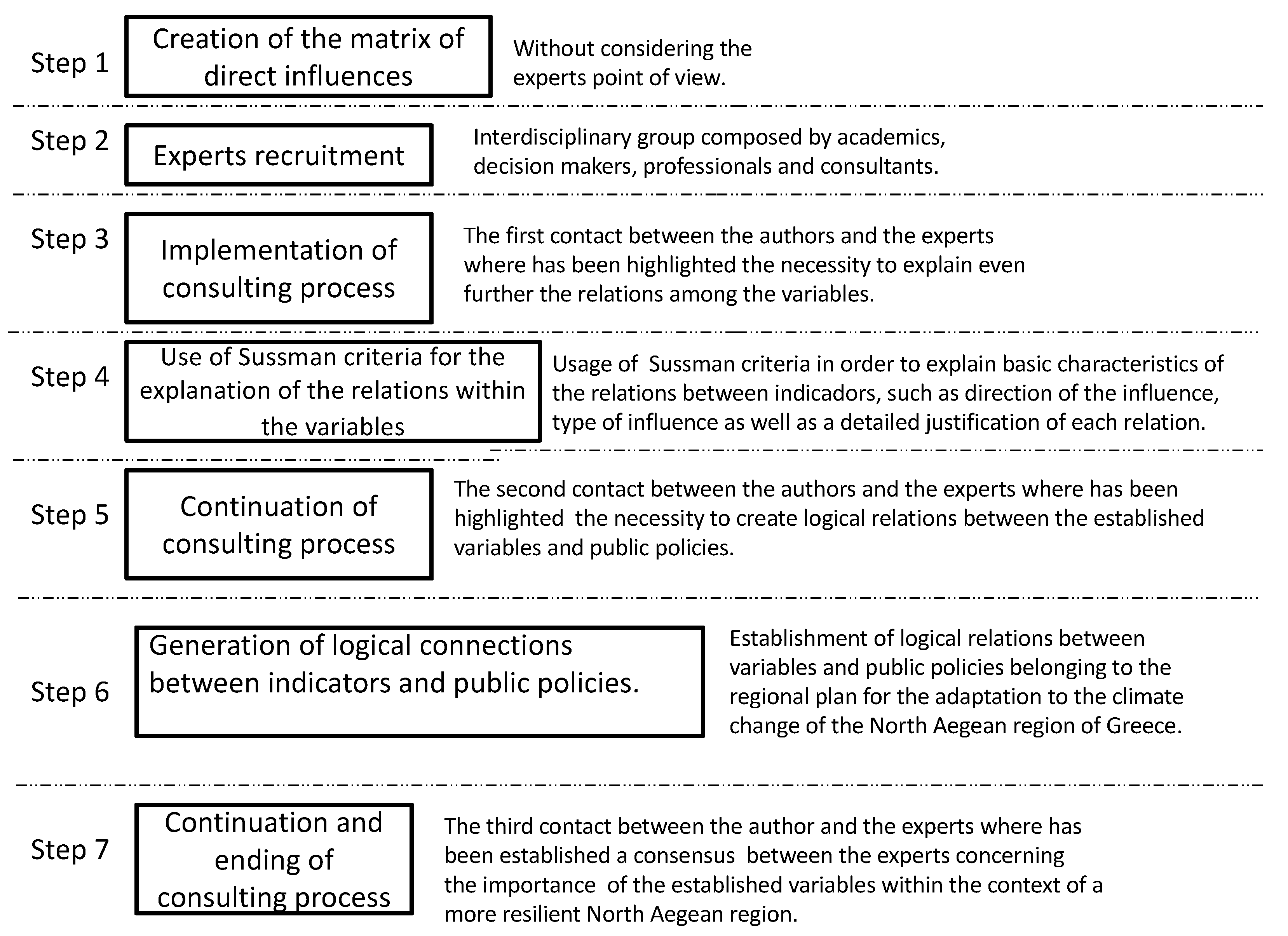
  • Phase 1. Expert consulting.
  • Phase 2. Discover the direct relations between the variables of the study.
  • Phase 3. Fill the matrix with “0” and “1”.
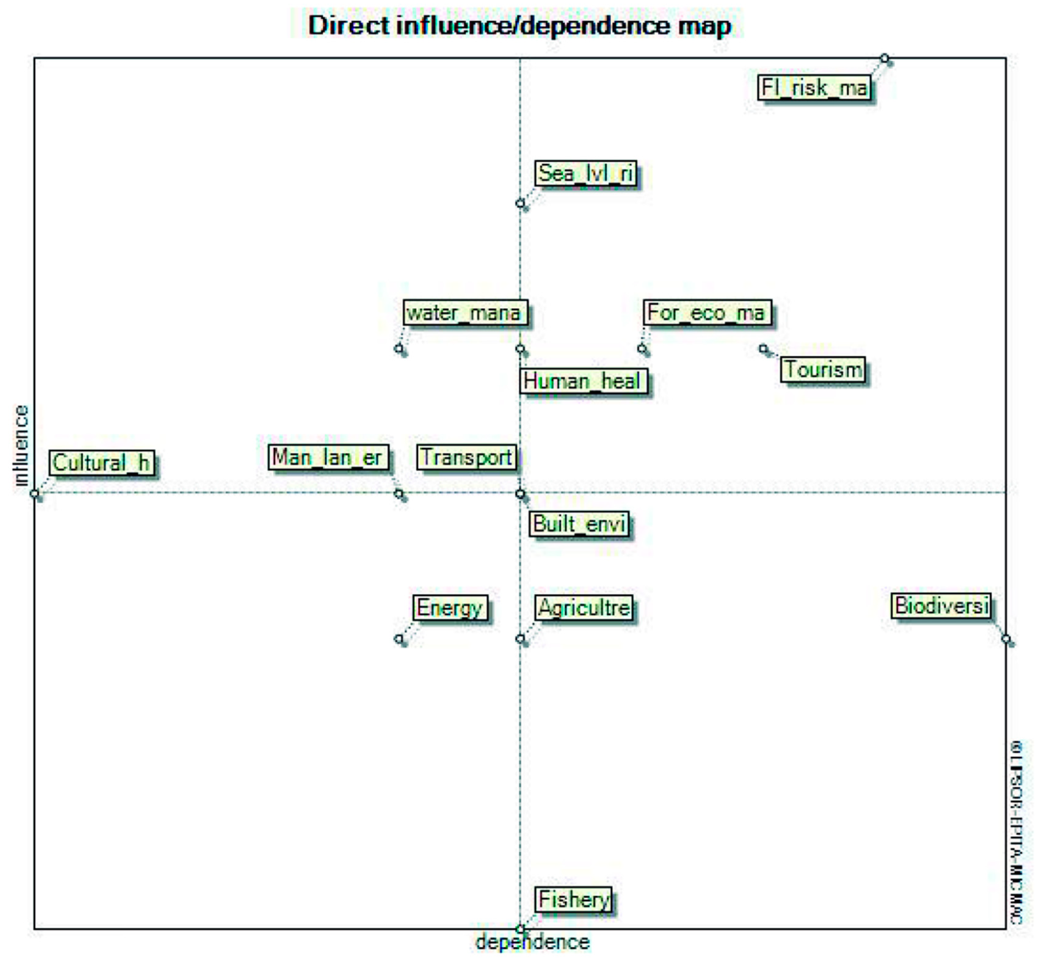
  • Phase 4. Categorize the variables in terms of influence and dependence.
  • Phase 5. Diagrammatically represent the matrix of direct interlinks.
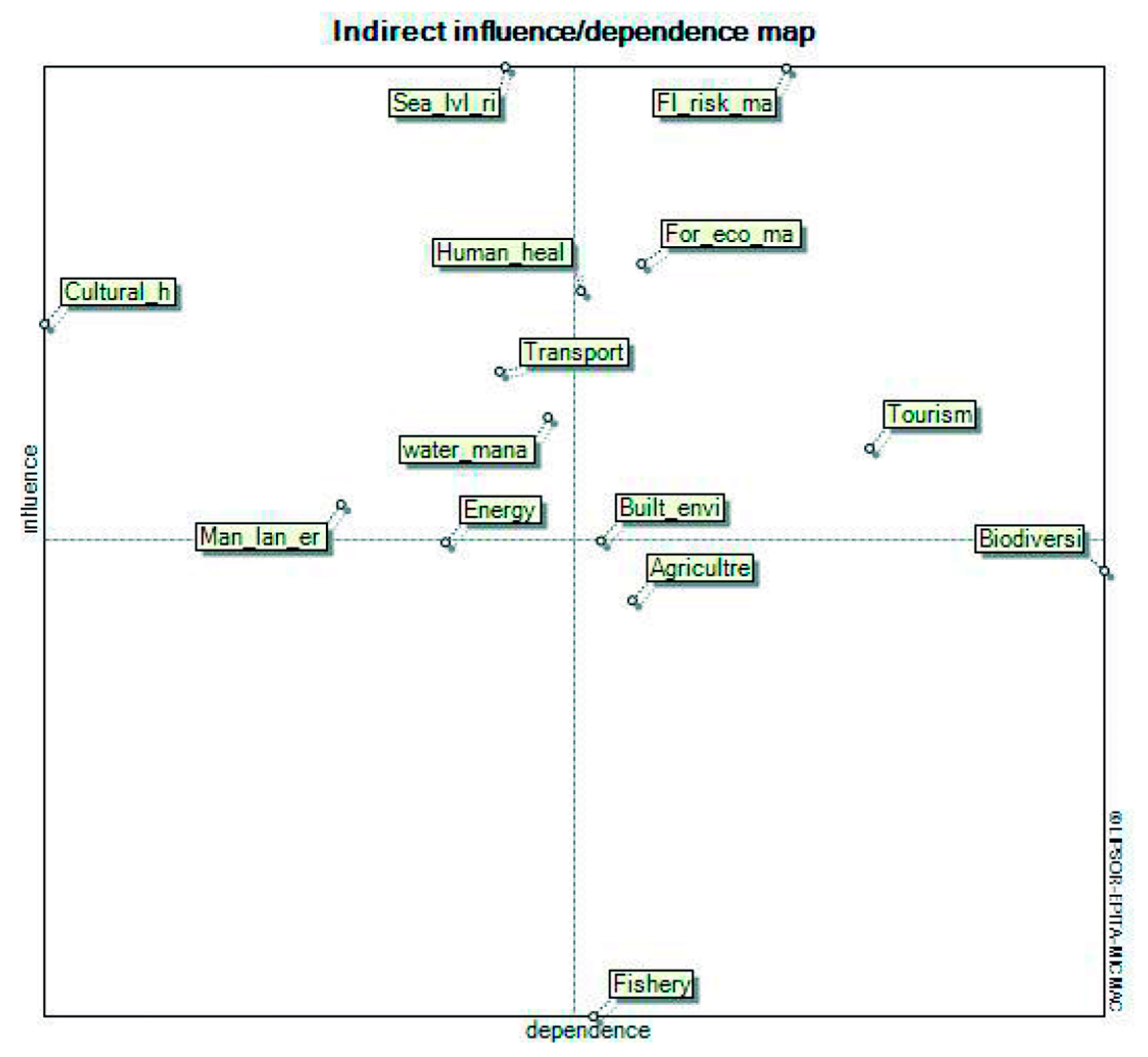
  • Phase 6. Elevate the matrix to the square so as to identify the indirect relations of second order.
  • Phase 7. Categorize the variables concerning the indirect influence and dependence.
  • Phase 8. Compare the hierarchical organization of each variable between the matrix of direct and indirect relations of second order.
  • Phase 9. Is the hierarchical organization of variables equal?
  • Phase 10. If the categorization of variables remains untouched, then the stabilization of the matrix has been achieved. If not, it is necessary to continue elevating the matrix to successive powers until the ranking of each variable, concerning the rates of influence and dependence between power n and power n − 1, is equal.
After the achievement of the matrix’s stabilization results, the diagrammatic illustration seen in (Figure 5) that not only takes into account the direct relations among the variables but also the indirect ones was created. As a result, several variables (rise of sea level, energy and built environment) changed their position and, via the indirect categorization process, are presented in a different sector from the one occupied in Figure 4.

3.4. Verification of the Interlinks among the Vulnerable Sectors of the North Aegean Region

Table 3 contains the justifications of the relationships between the plan’s sectors via the conduction of literature review, so as to enrich the experimental–empirical results extracted from the experts panel with theoretical evidence.

4. Results

The resilience of a city or a region is a crucial factor to be considered in relation to the inevitable effects of climate change, which the world already experiences. Considering, primarily, that climate change mitigation policies require global action and, secondarily, that the potential of the Greek economy to significantly affect the production of greenhouse gases due to its small size is almost zero, the implementation of targeted actions of adaptation is the only way to reduce the impact of climate change. The adaptation is expected to be essential for developed countries, such as Greece, which are going to be severely affected by climate change.
Hence, the generation of holistic and prospective approaches that encourage the adaptation of a city, metropolis or region to climate change should be prioritized. Therefore, comprehensive adaptive plans should not solely emphasize a specific and vulnerable sector to climate change but should try to integrate several sensitive sectors within the negative effects of climate crisis. Taking into account the aforementioned experience, this study implemented a prospective study to the vulnerable sectors of the North Aegean Region of Greece against climate change so as to structure them in order of importance through the determination of the interlinks among them. Thus, various measures and lines of action related to the region’s resilience can be classified according to their results based on the negative effects of climate change and the consequent co-benefits that are going to be produced by their application for the social, economic and environmental elements of the region.
The classification of all the aforementioned variables and their relations with various lines of action belonging to the regional plan for the mitigation of climate change within the North Aegean Region can be appreciated in the following Table 4, Table 5 and Table 6.
All of the measures described above can be implemented in parallel and there is no obligation for them to be sequential. However, it is very important for all of them to be part of a comprehensive long-term plan with specified, and in some cases even periodical, timetables rather than sporadically executed lines of action. Nonetheless, coordination, communication and participation among agents of different political order and hierarchy is critical for the adequate implementation of regional adaptive plans against climate change.

5. Discussion

Within a structural analysis, the variables located in quadrant 2 are very important because they present high rates of influence and dependence; hence, they are essential factors that need to be considered for the improvement of the overall system’s performance. In our study, several key variables can be appreciated in quadrant 2 (Figure 5), such as forest ecological management, flood risk management, built environment, tourism, and human health. All of them are very important factors to be considered within the framework of a region’s resilience due to the fact that climate change can cause extreme weather phenomena, such as flooding and consequent landslides, that can cause severe problems to the region’s infrastructure as well as to the physical and mental health of its inhabitants [65,66]. In the same quadrant, we have the variable of built environment. This is one of the sectors with the greatest contributions to the worsening of climate change, as the energy consumed by buildings releases huge amounts of greenhouse gas [67]. Hence, the challenge is to implement appropriate measures which will reduce the energy needs of the buildings. In this way, a reduction will be achieved in terms of emissions while, at the same time, the adaptation of buildings to extreme climatic phenomena will increase. To all this, sharpened effects, such as increased evaporation, increased irrigation, and the continuous increase in water consumption, must be also added, which are the results of the changes in land use, mainly due to the transformation of rural areas into tourist areas [15]; therefore, the variable of tourism is located in the same quadrant. The last variable within quadrant 2 is forest ecosystem management because forest ecosystems are at risk from the extreme phenomena caused by climate change (desertification, flooding, fires, etc.) [15]. Thus, it is necessary to take appropriate actions so as to protect the ecosystems and minimize the impact upon them.
However, the variables seen in quadrant 1 are fairly critical as they are able to determine the performance of the system. In quadrant 1 can be found the variables of sea level rise, water management, cultural heritage, landslide management, transport, and energy. The sector related to the rise in water level is particularly vulnerable to climate change and its implications cause adverse effects on the well-being of the population [68]. The objective is to reduce the effects of climate change via the implementation of appropriate measures (for instance, studies of coastal vulnerability, the generation of coast inventories, the construction of windward moles, etc).
In the same quadrant is located the variable of water management, which is heavily affected by climate change (decrease in rainfalls, increase in temperature, evaporation, water quality, and water consumption needs) [15,69]. To this problematic situation, the loss of water from the outdated systems of urban water supply networks and the continuous but also seasonal increase in water consumption due to local native population growth and tourist population growth should be also added [15]. Hence, it is of paramount importance to implement lines of action that will protect water systems from the impact that climate change will have on them and, consequently, contribute to the social and economic well-being of the population. In the same quadrant, the variable of culture heritage can also be found, which is truly in danger due to climate change [70]. The latter is becoming a very important damage factor, in addition to other risk elements, and contributes greatly to the deterioration of several cultural assets. Consequently, the objective is to apply measures for the mitigation of the negative effects of climate change on cultural heritage within the Region of North Aegean (for example, the study of the phenomenon of disintegration in the area of Osia Moni Theoktisti in Ikaria).
The sector of transport is also a basic contributor to the climate crisis because transportation projects and transport modes are able to generate various negative externalities, such as air pollution, barrier effects, water pollution, congestion, and road accidents, which severely affect the quality of people’s lives. Furthermore, the sector of landslides management is located in quadrant 1 as well, due to the fact that landslide phenomena have the capacity to cause damage to built environments, such as dams, houses, and transportation arteries, and also to human health (deaths and injuries).
The last variable in the quadrant 1 is that of energy, which, globally, represents a main contributor of GHG emissions. Approximately, 67% of global GHG production is related to the use of fossil fuels for energy to be used for heating, industry, transport, and electricity [71]. So, it is essential to promote alternative forms of energy in order to enhance the resilience of the region but also the compliance with sustainable development goals.
In quadrant 3, variables such as agriculture, fishery, and biodiversity are appreciated, which are important variables for the establishment of a resilient and sustainable environment and the improvement of the quality of people’s lives. Simultaneously, they are strongly influenced by multiple other established variables considered for this thematic study, such as water management, forest ecology management, flood risk management, rise in sea level, tourism, and energy, and consequently, it is preferable to be handled indirectly through them.

6. Conclusions

The principal component of this study is the establishment of a diagrammatic illustration including the most vulnerable sectors to climate change that allows the understanding of the main elements and the nature of the interlinks among them. Hence, policy-making bodies are able to realize that comprehensive mitigation processes against climate deregulation, in comparison to centralized, monodisciplinary approaches, are more efficient and produce multiple benefits for the society.
The most important sector for the mitigation of climate change, at least in our case study, is flood risk management, due to its high rate of influence and dependence, and is followed by forest ecosystem management, built environment, landslides and soil erosion management and human health. Equally important for the mitigation of climate change are the sectors located in quadrant 1, as they are highly influential. The most important of them is the sector of sea level rise, which is followed by the sectors of tourism, water management, energy, and cultural heritage. The example of the agriculture and biodiversity sectors is a special one because they are both located very close to quadrant 2. Thus, they should also be considered as “key” factors that, if not handled carefully, may destabilize the overall performance of the system under study. The last of the determined vulnerable sectors against climate change (fishery) should be handled via the ones that strongly impact it (sea rise level, water management, and biodiversity).
As a consequence, the most essential measures and lines of action are the ones associated to flood risk management (e.g., preparation of master plans for flood protection projects, the construction of dams, the replacement and completion of existing rainwater drainage networks, etc.) as they can protect various other sectors (such as built environment, biodiversity, human health, management of landslides, and transport), followed by the measures associated to forest ecosystem management (e.g., financing of private and municipal forest management studies, creation of fire fighting stations, support for the prevention of forest damage from forest fires, natural disasters, and catastrophic events, etc.). Once the aforesaid lines of action are well established, it is preferable to continue with countermeasures oriented to the upgrade of built environment so as to enhance urban green and the use of bioclimatic materials and for this to be followed by lines of action related to landslides and soil erosion management (i.e., reforestation studies) and human health (i.e., protection against mosquito-borne diseases).
The very important strategies for the adaptability of the North Aegean Region against climate change are the ones associated to the rise of sea level (i.e., monitoring, recording, and dealing with coastal erosion, coastal floods, and sea level rise, generation of coastal inventory, etc.), energy (e.g., development of smart grids for managing electricity demand), tourism (i.e., expansion of tourist period through the development of alternative forms of tourism and the modernization of existing businesses), water management (e.g., irrigation project studies, studies for the construction of dams, actions oriented to the improvement of the efficient use of water, etc.), and cultural heritage (i.e., study on the phenomenon of disintegration in the area of Osia Moni Theoktisti in Ikaria). In a complementary way, measures oriented to the transport, biodiversity, agriculture, and fishery sectors can be applied.
A future move to take under advisement is the application of a structural analysis approach, considering the intensity of interlinks between the variables, and social mixed-method approaches in order to evaluate adaptive policies to climate change with their associated measures and lines of action and see if the opinion of the experts is consistent or against people’s opinion, in terms of the classification of climate-sensitive sectors.

Author Contributions

Conceptualization, I.C.; formal analysis, I.C. and E.B.; investigation, I.C., L.A.-I., E.B. and C.K.; methodology, I.C.; supervision, I.C.; writing—original draft preparation, I.C.; writing—review and editing, E.B., C.K. and L.A.-I. All authors have read and agreed to the published version of the manuscript.

Funding

This research received no external funding.

Acknowledgments

The first author specially acknowledges the support from the DGAPA scholarship program.

Conflicts of Interest

The authors declare no conflict of interest.

References

  1. Jamison, A. The technological character of the city: Modernity and Urban Life in Europe. In Greening the City: Urban. Environmentalism from Mumford to Malmö; Mikael, H., Thomas, M., Eds.; University Studio Press: Athens, Greece, 2008. [Google Scholar]
  2. Beriatos, E. Environment: The main goal of spatial planning. In Proceedings of the International Two-day Conference: Medium Cities and Environmental Planning, Volos, Greece, 16–18 May 2008. [Google Scholar]
  3. Bakogiannis, E.; Kyriakidis, C.; Siti, M.; Eleftheriou, V.; Siolas, A. Urban planning VS environment: Re conciliating the conflicts. In Proceedings of the 4th Pan-Hellenic Conference in Rural and Surveying Engineering, Thessaloniki, Greece, 26–28 September 2014. [Google Scholar]
  4. Delgado Ramos, G.C. Climate Change-Sensitive Cities: Building Capacities for Urban Resilience, Sustainability, and Equity; National Autonomous University of Mexico Research Program on Climate Change: Mexico City, Mexico, 2017. [Google Scholar]
  5. Chatziioannou, I.; Alvarez-Icaza, L.; Bakogiannis, E.; Kyriakidis, C.; Chias-Becerril, L. A CLIOS Analysis for the Promotion of Sustainable Plans of Mobility: The Case of Mexico City. Appl. Sci. 2020, 10, 4556. [Google Scholar] [CrossRef]
  6. Aravantinos, I. Urban. Planning: For a Sustainable Development of the Urban Space; Symmetria Publications: Athens, Greece, 2007. [Google Scholar]
  7. Lefebvre, H. La Revolucion Urbana; Alianza Editorial: Madrid, Spain, 1983. [Google Scholar]
  8. Binde, J. Tomorrow the cities. In Cities and Environment in the 21st Century. A Future-Oriented Composition after Habitat II; Lefas, P., Ed.; Plethron Publications: Athens, Greece, 2003. [Google Scholar]
  9. UNDP. Human Development Report; United Nations Development Programme: New York, NY, USA, 2011. [Google Scholar]
  10. UN-Habitat. Estado de las ciudades de America Latina y el Caribe. In Programa de las Naciones Unidas para los Asentamientos Humanos; ONUHabitat: Rio de Janeiro, Brazil, 2012. [Google Scholar]
  11. UN. Las Naciones Unidas y la Asistencia Humanitaria. Organizacion de las Naciones Unidas. Available online: www.un.org/es/humanitarian/overview (accessed on 4 May 2017).
  12. Bakogiannis, E.; Kyriakidis, C.; Siti, M.; Milioni, T.; Potsiou, C. Increasing urban resilience of Athens’ Historic Center. In Proceedings of the FIG Working Week, Helsinki, Finland, 29 May–2 June 2017. [Google Scholar]
  13. Evans, M. Resilient City-Definition and Urban Design Principles: Building Cities to be more Resilient to Physical, Social and Economic Challenges. Available online: https://www.thebalance.com/resilient-city-definition-and-urban-design-principles-3157826 (accessed on 17 September 2020).
  14. Lucatello, S. Tendencias de la Política Medioambiental en la Union Europea y America del Norte: ¿Integracion o Cooperacion? In Cooperacion Internacional Para el Medio Ambiente (CIPMA): Tendencias Actuales y Desafios; Chanona Burguete, A., Sosa Nuñez, G.S., Eds.; FCPySPINCC-UNAM: Mexico City, Mexico, 2014. [Google Scholar]
  15. Progiou, A.; Dimitrakopoulos, D.; Karalis, K.P.; Doptidis, G.; Evaggelidou, E.; Dimitrakopoulou, S. Περιφερειακό Σχέδιο για την Προσαρμογή στην Κλιματική Aλλαγή (ΠεΣΠΚA) Βορείου Aιγαίου, Στρατηγική Μελέτη Περιβαλλοντικών Επιπτώσεων. Ειδική Υπηρεσία Διαχείρισης Ε.Π. Περιφέρειας Βορείου Aιγαίου. Available online: https://www.pvaigaiou.gov.gr/dyn/userfiles/files/pdf-diavouleysh/PESPKA_BOREIO_AIGAIO.pdf (accessed on 12 May 2020).
  16. Pavlis, E. North Aegean island landscapes as ecomuseums: The case of Lesvos Island. Isl. Stud. J. 2017, 12, 135–150. [Google Scholar] [CrossRef]
  17. Bouloutza, P. Greece’s Population Shrinking, Aging. Available online: https://www.ekathimerini.com/233090/article/ekathimerini/news/greeces-population-shrinking-aging#:~:text=A%20bleak%20future%20lies%20ahead,800%2C000%20and%202.5%20million%20people. (accessed on 28 November 2020).
  18. United States Environmental Protection Agency. Climate Change and the Health of Older Adults. Available online: https://cerch.berkeley.edu/sites/default/files/climate_change_and_the_health_of_older_adults.pdf (accessed on 29 November 2020).
  19. UNFCCC. United Nations Framework Convention on Climate Change; FCCC/INFORMAL/84 GE.05-62220 (E) 200705; United Nations: New York, NY, USA, 1992. [Google Scholar]
  20. Ballesteros Riveros, D.P.; Ballesteros Silva, P.P. Análisis estructural prospectivo aplicado al sistema logístico. Sci. Tech. Año Xiv 2008, 39, 194–199. [Google Scholar]
  21. Wanty, J.; Federwish, J. Modeles Globaux D’economie D’entreprise; Dunod: Paris, France, 1969. [Google Scholar]
  22. Arcade, J.; Godet, M.; Roubekat, F. Structural Analysis with the Micmac Method & Actors’ strategy with Mactor Method; IIEP/UNESCO Publishing: Paris, France, 1993. [Google Scholar]
  23. Kane, J. A primer for a new cross impact language-KSIM. Technol. Forecast. Soc. Chang. 1972, 4, 129–142. [Google Scholar] [CrossRef]
  24. Roberts, F. Signed digraphs and the growing energy demand. Environ. Plan. A 1971, 3, 395–410. [Google Scholar] [CrossRef]
  25. Duperrin, J.C.; Godet, M. Méthode de Hiérarchisation des Éléments d’un Système: Essai de Prospective du Système de L’énergie Nucléaire Dans son Contexte Societal; Commissariat à l’énergie Atomique: Paris, France, 1973. [Google Scholar]
  26. Sharma, H.; Gupta, A.; Sushil. The objectives of waste management in India: A futures inquiry. Technol. Forecast. Soc. Chang. 1995, 48, 285–309. [Google Scholar] [CrossRef]
  27. Arya, D.S.; Abbasi, S.A. Identification and classification of key variables and their role in environmental impact assessment: Methodology and software package intra. Environ. Monit. Assess. 2001, 72, 277–296. [Google Scholar] [CrossRef]
  28. Kanungo, S.; Duda, S.; Srinivas, Y. A structured model for evaluating information systems effectiveness. Syst. Res. Behav. Sci. 1999, 16, 495–518. [Google Scholar] [CrossRef]
  29. Kim, J.H.; Barnett, G.A. A structural analysis of international conflict: From a communication perspective. Int. Interact. 2007, 33, 135–165. [Google Scholar] [CrossRef]
  30. Qureshi, M.N.; Dinesh Kumar, P.K. An integrated model to identify and classify the key criteria and their role in the assessment of 3pl services providers. Asia Pac. J. Mark. Logist. 2008, 20, 227–249. [Google Scholar] [CrossRef]
  31. Chatziioannou, I.; Alvarez-Icaza, L. A structural analysis method for the management of urban transportation infrastructure and its urban surroundings. Cogent Eng. 2017, 4, 1326548. [Google Scholar] [CrossRef]
  32. Chatziioannou, I.; Alvarez-Icaza, L.; Bakogiannis, E. A structural analysis method for the promotion of Mexico City’s integral plan of mobility. Cogent Eng. 2020, 7, 1759395. [Google Scholar] [CrossRef]
  33. Chatziioannou, I.; Alvarez-Icaza, L.; Bakogiannis, E.; Kyriakidis, C.; Chias-Becerril, L. A Structural Analysis for the Categorization of the Negative Externalities of Transport and the Hierarchical Organization of Sustainable Mobility’s Strategies. Sustainability 2020, 12, 6011. [Google Scholar] [CrossRef]
  34. Chatziioannou, I.; Alvarez-Icaza, L. Evaluation of the urban transportation infrastructure and its urban surroundings in the Iztapalapa County: A geotechnology approach about its management. Cogent Eng. 2017, 4, 1330854. [Google Scholar] [CrossRef]
  35. Khan, U.; Haleem, A. Smart organisations: Modelling of enablers using an integrated ISM and fuzzy-MICMAC approach. Int. J. Intell. Enterp. 2012, 1, 248–269. [Google Scholar] [CrossRef]
  36. Romero Perea, A. Metodología Para la Jerarquización de Políticas de Transporte Urbano de Pasajeros Que Minimicen las Externalidades Negativas. Master’s Thesis, Universidad Nacional Autónoma de México, Mexico City, Mexico, 2012. [Google Scholar]
  37. Colodni, L. Construcción de la Base de Escenarios del Modelo MEDEE-S, Aplicación al Transporte de Caracas; Universidad Simón Bolivar: Venezuela, Caracas, 1987. [Google Scholar]
  38. Bernacsek, G. Environmental Issues, Capacity and Information Base for Management of Fisheries Affected by Dams. Available online: http://www.fao.org/3/Y2785E/y2785e05.htm (accessed on 29 November 2020).
  39. Union of Concerned Scientists. Our Energy Choices: Energy and Water Use. Available online: https://www.ucsusa.org/resources/energy-and-water-use (accessed on 1 December 2020).
  40. Nunez, C. Sea Level Rise, Explained. Available online: https://www.nationalgeographic.com/environment/global-warming/sea-level-rise/#:~:text=Consequences&text=When%20sea%20levels%20rise%20as,fish%2C%20birds%2C%20and%20plants (accessed on 28 November 2020).
  41. López-Dóriga, U.; Jiménez, J.A.; Valdemoro, H.I.; Nicholls, R.J. Impact of sea-level rise on the tourist-carrying capacity of Catalan beaches. Ocean. Coast. Manag. 2019, 170, 40–50. [Google Scholar] [CrossRef] [Green Version]
  42. Nidhinarangkoon, P.; Ritphring, S.; Udo, K. Impact of sea level rise on tourism carrying capacity in Thailand. J. Mar. Sci. Eng. 2020, 8, 104. [Google Scholar] [CrossRef] [Green Version]
  43. Agnew, M.D.; Viner, D. Potential Impacts of Climate Change on International Tourism. Tour. Hosp. Res. 2001, 3, 37–60. [Google Scholar] [CrossRef]
  44. Baran, E.; Starr, P.; Kura, Y. Influence of Built Structures on Tonle Sap Fisheries; Cambodia National Mekong Committee and the WorldFish Center: Phnom Penh, Cambodia, 2007. [Google Scholar]
  45. World Tourism Organization. Tourism and Biodiversity. Achieving Common Goals towards Sustainability; World Tourism Organization: Madrid, Spain, 2010. [Google Scholar]
  46. Lusk, S.; Hartvich, P.; Halacka, K.; Luskova, V.; Holub, M. Impact of extreme floods on fishes in rivers and their floodplains. Ecohydrol. Hydrobiol. 2003, 4, 173–181. [Google Scholar]
  47. Carlson, A.K.; Fincel, M.J.; Longhenry, C.M.; Graeb, B.D.S. Effects of historic flooding on fishes and aquatic habitats in a Missouri River delta. J. Freshw. Ecol. 2016, 31, 271–288. [Google Scholar] [CrossRef] [Green Version]
  48. Chukwu Okeah, G.O.; Wekpe, V.E.; Ikebude, C.F. Impact of Coastal Flooding on Fish Production in Brass, Niger Delta Nigeria, Implication for Coastal Resource Management. Oceanogr. Fish. 2018, 6, 555678. [Google Scholar]
  49. Geertsema, M.; Highland, L.; Vaugeouis, L. Environmental Impact of Landslides. In Landslides—Disaster Risk Reduction; Sassa, K., Canuti, P., Eds.; Springer: Berlin, Germany, 2009. [Google Scholar]
  50. Dudley, N.; Alexander, S. Agriculture and biodiversity: A review. Biodiversity 2017, 18, 45–49. [Google Scholar] [CrossRef]
  51. Banerjee, L. Effects of Flood on Agricultural Productivity in Bangladesh. Oxf. Dev. Stud. 2010, 38, 339–356. [Google Scholar] [CrossRef]
  52. O’Connell, P.E.; Ewen, J.; O’Donnell, G.; Quinn, P. Is there a link between agricultural land-use management and flooding? Hydrol. Earth Syst. Sci. 2007, 11, 96–107. [Google Scholar] [CrossRef] [Green Version]
  53. Vourdoubas, J. The Nexus between Agriculture and Tourism in the Island of Crete, Greece. J. Agric. Stud. 2020, 8, 393. [Google Scholar] [CrossRef] [Green Version]
  54. Karampela, S.; Kizos, T. Agritourism and local development: Evidence from two case studies in Greece. Int. J. Tour. Res. 2018, 20, 566–577. [Google Scholar] [CrossRef]
  55. Zagaria, C.; Schulp, C.J.E.; Kizos, T.; Verburg, P. Perspectives of farmers and tourists on agricultural abandonment in east Lesvos, Greece. Reg. Env. Chang. 2018, 18, 1467–1479. [Google Scholar] [CrossRef] [Green Version]
  56. Guliz Ugur, N.; Akbiyik, A. Impacts of COVID-19 on global tourism industry: A cross-regional comparison. Tour. Manag. Perspect. 2020, 36, 100744. [Google Scholar] [CrossRef]
  57. Hall, C.M.; Baird, T.; James, M.; Ram, Y. Climate change and cultural heritage: Conservation and heritage tourism in the Anthropocene. J. Herit. Tour. 2016, 11, 10–24. [Google Scholar] [CrossRef]
  58. Deschaux, J. Flood-related Impacts on Cultural Heritage. Floods 2017, 1, 53–72. [Google Scholar]
  59. Canuti, P.; Margottini, C.; Fanti, R.; Bromhead, E.N. Cultural Heritage and Landslides: Research for Risk Prevention and Conservation. In Landslides—Disaster Risk Reduction; Sassa, K., Canuti, P., Eds.; Springer: Berlin, Germany, 2009. [Google Scholar]
  60. Gluvačević, D. The Power of Cultural Heritage in Tourism—Example of the City of Zadar (Croatia). Int. J. Sci. Manag. Tour. 2016, 2, 3–24. [Google Scholar]
  61. Litman, T. Evaluating Transportation Land Use Impacts. Available online: https://www.researchgate.net/publication/255632796_Evaluating_Transportation_Land_Use_Impacts (accessed on 30 November 2020).
  62. Blumstein, D.; Geffroy, B.; Samia, D.; Bessa, E. Ecotourism’s Promise and Peril; Springer: Cham, Switzerland, 2017. [Google Scholar]
  63. Specht, J. Tourism and the Built Environment. In Architectural Tourism; Springer Gabler: Wiesbaden, Germany, 2014. [Google Scholar]
  64. Liu, G.; Liu, Z.; Hu, H.; Wu, G.; Limin, D. The impact of tourism on agriculture in Lugu Lake region. Int. J. Sustain. Dev. World Ecol. 2008, 15, 3–9. [Google Scholar] [CrossRef]
  65. Gariano, S.L.; Guzzetti, F. Landslides in a changing climate. Earth Sci. Rev. 2016, 162, 227–252. [Google Scholar] [CrossRef] [Green Version]
  66. Kleinen, T.; Petschel-Held, G. Integrated assessment of changes in flooding probabilities due to climate change. Clim. Chang. 2007, 81, 283–312. [Google Scholar] [CrossRef]
  67. Younger, M.; Morrow-Almeida, H.R.; Vindigni, S.M.; Dannenberg, A.L. The Built Environment, Climate Change, and Health Opportunities for Co-Benefits. Am. J. Prev. Med. 2008, 35, 517–526. [Google Scholar] [CrossRef]
  68. Mimura, N. Sea-level rise caused by climate change and its implications for society. Proc. Jpn. Acad. Ser. B Phys. Biol. Sci. 2013, 89, 281–301. [Google Scholar] [CrossRef] [Green Version]
  69. Muller, M. Adapting to climate change: Water management for urban resilience. Environ. Urban 2007, 19, 99–113. [Google Scholar] [CrossRef] [Green Version]
  70. Carroll, P.; Aarrevaara, E. Review of Potential Risk Factors of Cultural Heritage Sites and Initial Modelling for Adaptation to Climate Change. Geosciences 2018, 8, 322. [Google Scholar]
  71. European Environment Agency. Energy and Climate Change. Available online: https://www.eea.europa.eu/signals/signals-2017/articles/energy-and-climate-change (accessed on 30 October 2020).
Figure 1. The North Aegean Region of Greece.
Sustainability 12 10420 g001
Figure 2. Matrix of direct influences and dependencies.
Sustainability 12 10420 g002
Figure 3. The consulting process for the classification of variables related to climate change.
Sustainability 12 10420 g003
Figure 4. The location of variables as they result from the matrix of direct influences–dependencies.
Sustainability 12 10420 g004
Figure 5. The location of variables as they result from the matrix of indirect influences–dependencies.
Sustainability 12 10420 g005
Table 1. The established variables of the thematic study.
IDNomenclature of the Plan’s Critical Sectors against Climate ChangeSymbolization of the Established Critical Sectors for the Mitigation of Climate Change within the Software MICMAC
1Water managementWater_mana
2Sea-level riseSea_lvl_ri
3FisheryFishery
4Forest ecosystem managementFor_eco_ma
5Built environmentBuilt_envi
6BiodiversityBiodiversi
7Flood risk managementFl_risk_ma
8Management of landslides and erosionsMan_lan_er
9AgricultureAgricultre
10Human healthHuman_heal
11Cultural heritageCultural_h
12EnergyEnergy
13TransportTransport
14TourismTourism
Table 2. The composition of experts panel for our thematic study.
IDArea of Expertise/
Profession of Experts
General View of the Theme in Analysis
Expert 1GeographerHighlight the way the urban space and built environment has to be shaped in order to create solutions to the climate deregulation crisis.
Expert 2Urban Planner
Expert 3Civil EngineerRecognition of the risk that climate change represents for the development of infrastructure systems and how the latter, via adequate measurements, can be more resilient.
Expert 4Transport Engineer
Expert 5Environmentalist-Mechanical EngineerIdentification of the environmental footprints of the climate change within the NAR. Proposals for the reduction of climate crisis.
Expert 6Energy Consumption Expert
Expert 7Physicist
Expert 8Mechanical and Electrical Engineer Evaluate efficient ways for the development of smart grids for managing electricity demand and the promotion of sustainable forms of energy.
Expert 9Mining Engineer Assess the risks of climate change upon the region’s mineral resources.
Expert 10Policy-maker within Government AgenciesIdentify relations between the region’s vulnerable groups and strategies/public policies and lines of action.
Expert 11Policy-maker within Government Agencies
Expert 12Hydro-geologistAnalysis of climate change impacts on the water resources and landslides of the region.
Expert 13Tourism ExpertIdentification of the influence that the tourism-cultural heritage sectors exert upon the other sectors of the NAR.
Expert 14BiologistAnalysis of climate change impacts on biodiversity, fishery and human health.
Table 3. Verification of the relationships between the plan’s negative externalities.
IDEstablished Vulnerable SectorDirectly Related Vulnerable Sectors
1Water managementFishery, forest ecosystem management, biodiversity, agriculture, human health, energy [15,38,39]
2Sea-level riseBuilt environment, biodiversity, flood risk management, agriculture, human health, transport, tourism [40,41,42]
3FisherySea-level rise, biodiversity [15]
4Forest ecosystem managementBiodiversity, flood risk management, management of landslides and erosions, agriculture, human health, tourism [15,43]
5Built environmentFishery, biodiversity, flood risk management, human health, energy [15,44]
6BiodiversityWater management, sea-level rise, forest ecosystem management, flood risk management, tourism [15,45]
7Flood risk managementFishery, built environment, biodiversity, management of landslides and erosions, human health, agriculture, transport, tourism [15,43,46,47,48]
8Management of landslides and erosionsFishery, forest ecosystem management, biodiversity, flood risk management, human health [15,49]
9AgricultureForest ecosystem management, biodiversity, flood risk management, tourism [15,50,51,52,53,54,55]
10Human healthForest ecosystem management, built environment, biodiversity, transport, tourism [15,56]
11Cultural heritageSea-level rise, forest ecosystem management, flood risk management, management of landslides and erosions, tourism [15,57,58,59,60]
12EnergySea-level rise, Built environment, Flood risk management, Transport [15]
13TransportWater management, sea-level rise, flood risk management, management of landslides and erosions, energy [15,61]
14TourismWater management, fishery, built environment, agriculture, cultural heritage, energy [15,62,63,64]
Table 4. The hierarchical organization of the plan’s essential sectors and the associated lines of action for the mitigation of climate change within the North Aegean Region.
IDEstablished Variables for the Present Thematic StudySectorIdentified Measures and Lines of Action as They Result from the Regional Plan Oriented towards the Mitigation of Climate Change within the North Aegean Region
1Flood Risk Management2Preparation of strategic master plans for flood protection projects.
Integration in security plans of impacts and protection measures from leakage of pollutants after a flood based on hazard maps.
Replacement and completion of existing rainwater drainage networks.
Measures for maintenance and cleaning of infrastructures and watercourses.
Flood protection project studies.
Construction of Tsiknia dam.
Measures to mitigate the intensity of corrosion and detachment and transport of materials.
2Forest Ecosystem Management2Financing of private/municipal forest management studies.
Study for the creation of a fire fighting network in Chios.
Reduction in pressures on vulnerable ecosystems.
Support for the prevention of forest damage from forest fires, natural disasters and catastrophic events.
Support to prevent damage to forests from insect outbreaks.
3Human Health2Protection against mosquito-borne diseases.
Training of health professionals in disaster management for social organization and emergency management due to sudden disasters.
4Tourism2Actions oriented to the extension of the tourist season through the development of alternative forms of tourism.
Actions related to the extension of the tourist season, with emphasis on the modernization of existing businesses.
Subsidizing tourism enterprises for their adaptation to climate change.
5Built Environment2Enhancement of urban green and use of bioclimatic materials.
Upgrade/create a mechanism for assessing damage and compensations in buildings due to flood events.
Table 5. The hierarchical organization of the plan’s influential sectors and the associated lines of action for the mitigation of climate change within the North Aegean Region.
IDEstablished Variables for the Present Thematic StudySectorIdentified Measures and Lines of Action as they Result from the Regional Plan Oriented towards the Mitigation of Climate Change within the North Aegean Region
6Rise in Sea Level1Coastal vulnerability study: monitoring, recording and dealing with coastal erosion, coastal floods and sea level rise.
Generation of Actology (mathematical simulation of coastal floods and flood estimation of areas, measurements of sea level, sea currents and other environmental factors (temperature, salinity) of the coasts of the North Aegean Region).
Study for the implementation of a windward mole in Kambi Fournon.
Study for the extension of the windward mole in Aghios Kyrikas of Ikaria.
7Cultural Heritage1Risk investigation/elaboration of studies for the outdoor exhibits of fossil forests.
Study on the phenomenon of disintegration in the area of Osia Moni Theoktisti in Ikaria.
8Transport1Actions to strengthen the safety of the North Aegean Region’s road network.
Lighting installation to enhance the safety of the road network.
Protection works oriented to the corrosion of the coastal provincial road in the area Aghios Georgios Thermis of Lesbos.
9Water Management1Actions oriented to the improvement of the efficiency of water use in ground infrastructure.
Enhancement of environmental inspections and controls.
Maintenance study—repair of Thanous Limnos reservoir and irrigation network.
Irrigation project study: The case of Karlovasi.
Studies for the construction of dams and irrigation and water supply networks in several islands of the North Aegean Region.
Study for the efficient utilization of water resources within the Municipality of Samos.
10Energy1Development of smart grids for managing electricity demand.
Vulnerability assessment of the proposed renewable energy installation sites.
11Management of Landslides and erosions1Reforestation study.
Measures to mitigate the intensity of corrosion and detachment and transport of materials.
Table 6. The hierarchical organization of the plan’s dependent sectors and the associated lines of action for the mitigation of climate change within the North Aegean Region.
IDEstablished Variables for the Present Thematic StudySectorIdentified Measures and Lines of Action as They Result from the Regional Plan Oriented towards the Mitigation of Climate Change within the North Aegean Region
12Biodiversity3Activities oriented to the removal of materials and removal of illegal buildings close to wetlands.
Reducing pressures on vulnerable ecosystems due to overgrazing.
13Agriculture3Recording of the existence of zoonoses and phytopathogenic insects and weeds.
Support of the actions associated with the neutralization of olive tree flies.
Adaptation to climate change of the Rural Development Program
Installation of rainfall stations in the North Aegean Region.
14Fishery3Actions to protect the biodiversity of the marine environment from non-native species, such as changes in the composition of phytoplankton.
Publisher’s Note: MDPI stays neutral with regard to jurisdictional claims in published maps and institutional affiliations.

