UAV Photogrammetry Surveying for Sustainable Conservation: The Case of Mondújar Castle (Granada, Spain)


1
Escuela de Estudios Árabes (EEA, CSIC), 18010 Granada, Spain
2
Centro de Estudios Históricos del Valle de Lecrín y las Alpujarras (CEHVAL), Cádiar, 18440 Granada, Spain
*
Author to whom correspondence should be addressed.
Sustainability 2021, 13(1), 24; https://0-doi-org.brum.beds.ac.uk/10.3390/su13010024
Submission received: 24 November 2020
/
Revised: 17 December 2020
/
Accepted: 19 December 2020
/
Published: 22 December 2020
(This article belongs to the Special Issue Architectural and Civil Engineering Heritage: Graphical Documentation for Research, Conservation and Diffusion)
Abstract
:Mondújar Castle is an Andalusi fortress located in the Valle de Lecrín (Granada, Spain). It had strategic importance in the final years of the Kingdom of Granada. The king Muley Hacén lived there before passing away, resulting in the popularisation of Romantic legends around its construction. Despite these folktales, the fortress has never been surveyed or restored and a complete architectural graphic study of this place is lacking. Therefore, it is essential to document the architectural heritage to collect relevant information for conservation work. Our main goal is to better understand the origin, architectural influences and building phases of the fortress, which requires historical and surveying methods. We present a historical approximation, followed by a photogrammetric survey. This is the first study on the medieval fortress and its subsequent Castilian refortification (executed around 1500). We conclude that it is not plausible that this place was the location of any legendary palaces. Apart from its historical and constructive significance, the use of Islamic funerary elements, probably coming from the Royal Nasrid Cemetery, makes this castle unique. Therefore, the preservation and understanding of this monument should be a priority within the sustainable development of the region.
1. Introduction
Mondújar is a small Spanish village located in the southern part of the province of Granada. This settlement is part of Valle de Lecrín, which is a historical region that brings together 17 villages grouped into eight municipalities: Albuñuelas, Dúrcal, Lecrín, Nigüelas, Padul, El Pinar, El Valle and Villamena. Mondújar, like the whole of the Valle de Lecrín, is a rural and farming area, whose population is only 612 inhabitants [1]. Apart from its traditional agricultural activity, in recent decades, the region has made efforts to promote its natural and cultural heritage. Local authorities and associations are trying to develop a tourism industry that is able to create new economic opportunities for its population. In this way, Mondújar’s heritage—particularly its medieval castle—is advertised as one of Valle de Lecrín’s cultural attractions.
The main goal of this research is to provide an accurate study and perspective of Mondújar’s medieval stronghold. This fortress is listed under the Bien de Interés Cultural class (BIC, one of the categories of the heritage register in Spain) [2]. However, the building is partially ruined and neglected. Despite its severe damage, local media and regional tourism groups are promoting this fortress as one of the most relevant medieval places of the area, stressing erroneous and imprecise facts coming from several Romantic nineteenth-century legends. Since the first time we visited this military emplacement, we realised that it was being misunderstood, as the descriptions presented in the legends did not fit with the size and characteristics of the current remains. Based on our professional experience, we know that the conservation and sustainability of architectural heritage must be based on detailed data. In this paper, we are offering a more precise approximation for that medieval building to both facilitate a better future interpretation of it and provide a good framework for future desirable restorations. Among the results, we are presenting, for the first time, orthorectified plans and elevations of the castle obtained through photos taken with an unmanned aerial vehicle (UAV) or drone. We have also drawn a hypothetical view of its walls, which were built around 1500–1502, as an adaptation to early modern artillery.
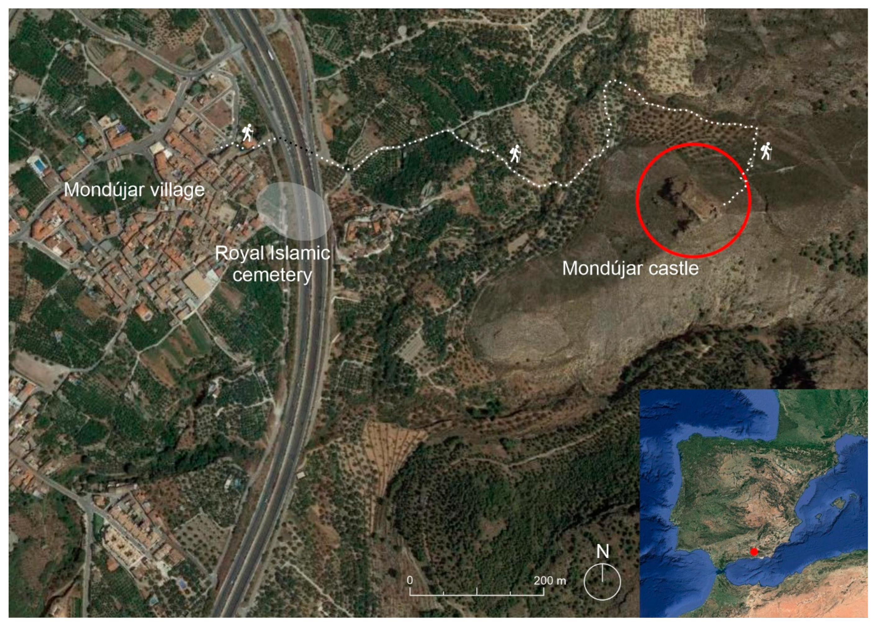
The former alquería of Mondújar is situated at the heart of the Valle de Lecrín, halfway between Granada, Las Alpujarras and the Mediterranean coast (Figure 1). It is located at the foot of the Sierra Nevada Mountains, 738 m.a.s.l., and close to the nearby Torrente River. Its name comes from the Arabic toponym qaryat mundūšar, which is probably a derivation of a hybrid place name formed by the Latin word mons-montis, “hill”, plus an Arabic or pre-Roman term [3,4,5]. Mondújar was settled from at least Late Antiquity; an important Roman bath complex (excavated in 1983) was located in the Feche zone [6]. We have a more precise knowledge about the settlement of Mondújar since the end of the Middle Ages and the beginning of the Early Modern period. At the end of the Nasrid Period, Mondújar was a village or alquería, part of the Valle de Lecrín rural district or taha. Likewise, its castle is known to have been a relevant fortress within the defensive regional group [7,8,9]. Immediately after the Conquest, the town was cited in the Granada archbishopric papal bull of erection as part of Béznar’s Parish [10]. In the same manner, its former mosques’ goods (habices) were listed in the roster of church properties made during 1501 [11].
According to the local Libro de Población (a surveying book written in 1572 for repopulation of the village after the Morisco revolt and its expulsion), Mondújar used to have fifty neighbours during the Morisco period, substituted by twenty new colonists [12]. At that time, the village was divided into two districts: The “Church neighbourhood”, located at the top of the settlement, near the main street and a cistern [12] (pp. 128r, 128v), and the low quarter, where a small plaza with a ruined rábita (Muslim shrine) was placed [12] (pp. 24r).
The castle lies on top of a sheer mountain (875 m.a.s.l.) named Pago del Castillejo. It is located approximately 1.2 km on foot from the village centre, following intricate and very steep trails. This location allows a strategic view of the neighbouring places of Acequias, Talará and Mondújar itself. In the same way, its situation also dominates two close cliffs belonging to Tablate—el Pleito and la Fuentezuela—as well as the road from Mondújar to the mountains.
This fortification is one of the best-documented structures of the Valle de Lecrín. Although Islamic sources do not cite this castle, it was probably built by the Nasrid dynasty (1238–1492), as they owned large properties in the surroundings [13,14]. A fact showing its relevance is that, together with the nearby ḥiṣn of Lanjarón, it was the only fortress of the area kept and occupied by the Castilians after the Conquest of Granada.
Quite possibly, the most popular bibliographic reference to this building is the 1874 article written by Francisco de Villa-Real y Valdivia. The author, using a Romantic and fantasising style, described Mondújar Castle in the following way:
“With undisguised charm Muley took his little Isabel, and showed her one by one the rooms of the castle: There were grandiose halls, perfectly decorated, and with beautiful lights; there was also a sumptuous mihrab, copied from the palace of Damascus; the steam baths were delicious, as well as the pure and charming atmosphere of the gardens; but where the enamoured Muley put all his care was in Zoraya’s dressing room, which for its elegance and sumptuousness was called to compete with the dressing room of the queen of the Alhamar palace. The usual fortification of the castle was not neglected for this, since its solid walls were covered with loopholes, whereby they could defend themselves from any attack.”(Translated by the authors, original text from [15])
In addition, the author remarks that the best architects from Córdoba built the fortress with great refinement under the orders of the Sultan Muley Hacén. According to Villa-Real, this exuberant construction was Muley Hacén’s present for his Christian concubine Isabel de Solis, who later became his wife as Zoraya. In the same manner, one year later, Manuel Gómez-Moreno González also elaborated on the same story. According to his work, the fortress of Mondújar was built by Muley Hacén as a recreation area with nice gardens and beautiful gates. Moreover, the author said it was the place where the ill and blind Muley Hacén retired and passed away after his brother, El Zagal, took power [16]. His son, Manuel Gómez-Moreno Martínez, repeated this statement in 1942 [13] (p. 270).
While the previous popular legends have been accepted as true facts—even officially—the historic data available for this stronghold present a different view. Luis del Mármol Carvajal wrote in his chronicle about the Granada War that Muley Hacén moved to Mondújar in 1482, after being overthrown by his son Boabdil. From that place, he and his soldiers waged war. Mármol also says that, the following year, Muley Hacén recovered the throne of Granada. However, he was forced to retire to Mondújar after becoming old and disabled, dying there in 1485. Not much detail about the castle itself is given in this chronicle [17].
In 1549, Juan Jusepe de Herrera provided further details regarding the significance of the fortification. This Béznar resident gave his testimony in favour of repairing the castle and considering the need for an alcaide (governor) in the—at that time—empty fortress. Juan Jusepe de Herrera started by saying that Mondújar Castle was very important for the protection of Valle de Lecrín and Las Alpujarras because of its strategic position. He also recalled that the king, Boabdil, after leaving the Alhambra, moved the Nasrid royal cemetery (rawda) to Mondújar. According to Herrera, this happened because Boabdil expected to receive the fortress from the Catholic Monarchs as his dwelling [13] (p. 278). Clearly, his objective was frustrated since the Catholic Monarchs, aware of the strategic position of this stronghold, took control of it by establishing an alcaide there. According to Miguel Ángel Ladero Quesada, the first designated alcaide was Sancho Deyo [18], who held this position for the first years after the Conquest of Granada. Thanks to several files preserved in the General Archive of Simancas, we know the governors of the fortress of Mondújar [19,20]. After Sancho Deyo, the Catholic Monarchs gave the rule of the castle to Pedro de Zafra (brother of their royal secretary) on 30 April 1494. Pedro de Zafra died during a Morisco revolt and his son Francisco de Zafra, also known as Francisco de Alarcón, inherited the governance. When Francisco de Zafra passed away, in his will (8 November 1543), he left the governance to his brother-in-law Francisco Carrillo de Guzmán. From 1550 to 1576, Captain Charles de Zuñiga was the alcaide of the place. On 30 July 1576, María de Reinoso, Pedro de Reinoso’s daughter, held the charge. Since María was a single lady, her uncle Juan de Enao provisionally took possession. Subsequently, María de Reinoso married Pedro de Velasco, who, in 1580, was designated as the governor of the fortress (Table 1).
An important episode in the history of this stronghold happened in 1500, when the Granada Mudéjares (Muslims of Al-Andalus living in Iberia after the Catholic conquest) revolted against the forced Catholic conversion. The chronicler Luis del Mármol described that, during that revolt, both Las Alpujarras and Valle de Lecrín became active rebel places and an important number of Castilian forts were lost there. In this setting, Pedro de Zafra’s wife, María de Acuña (also cited as Guiomar de Acuña), bravely defended Mondújar Castle: A Mudéjar insurgent group besieged the fortress while she happened to be there without her husband [17] (p. 79). The guard was composed of 40 foot soldiers, which was a much smaller number than the attackers’ one [21]. The Catholic Monarchs warned Pedro de Zafra about this event and he quickly reached the fortification to negotiate an agreement with the Mudéjares. Since obtaining a deal was impossible, he unsuccessfully tried to get into the stronghold with eleven servants, all of whom were killed by the rioters. Meanwhile, María de Acuña defended the castle until the Catholic Monarchs arrived at Padul and helped her [13] (p. 273).
As we can see, during the first years after the Conquest of Granada, Mondújar Castle was occupied and we know that certain building works took place. In the General Archive of Simancas, Contaduría Mayor de Cuentas section, file 1282, document 15 lists the payments made during the years 1500–1502 for two phases of improvement works carried out in the fortress. Pedro Ruys, a stonemason from Granada, was paid for 49 wall units (tapias) made with masonry and lime mortar. The walls were similar to those built by himself in the nearby Lanjarón Castle. Likewise, the master stonemasons Alonso Jurado and Juan Meneses were compensated for 142 wall units—tapias reales—each one five palms high, 10 long, and six wide (around 1.05 × 2.10 × 1.21 m, respectively). Those walls were made in masonry with lime mortar, with a mixture of two lime hod measures per three of sand [22].
Nonetheless, on 29 September 1550, when Charles de Zuñiga was designated as its alcaide, the stronghold was described as an abandoned and ruined place, without doors, keys, artillery or ammunition. Likewise, it was specified that an important part of the building was falling down and that the castle had been empty for a long time [19].
In 1566, when Pedro de Reinoso owned the fortress, it was cited as spoiled [19]. This bad situation was possibly caused by the negligence of the alcaides, who, despite receiving the corresponding rents, neither attended to the castle itself nor the control of the territory.
There is a lack of news about this fortification during the Revolt of the Alpujarras (1568–1571). The chronicles of this war do not refer to this castle because, in those years, it was already derelict.
In the same manner, after the expulsion of the Morisco population from the region, the castle must have become useless. In fact, in the local Libro de Población (1572), the fortress is barely cited and when mentioned, is done so in an indirect way. In fact, the book refers to the hill where the castle lays as being used as farmland [12] (65r).
Since the fortification was abandoned, in 1576, several persons described the bad conservation of the building. Andrés González, a native from Ciudad Real (Jaén), testified that he was recently in Mondújar and the castle was mainly destroyed and uninhabitable. He also mentioned that the only preserved part was a wall of the tower gate, which, in his words, seemed to be a relatively recent building work [19]. Agustín Pérez, a scribe from Granada, made the same observation. He testified that the fortress was destroyed, remarking that it was impossible to live there as just one wall located in the entrance was in good condition [19].
However, the castle has remained a relevant landmark for Mondújar. Tomás López, in his Geographical Dictionary (18th century), stated—following the local tradition—that Aben Humeya, a Morisco leader, hid in this fortress during the Rebellion of the Alpujarras (1568–1571) [23].
Moreover, the Catastro de Ensenada (also from the 18th century) contains a drawing of Mondújar representing the castle as a ruined building. Maybe due to that deterioration or even because of its small size, the fortification is cited as a castillejo, which is a diminutive of the word “castle” [24]. Finally, Pascual Madoz, in his Geographical Dictionary (1845–1850), only mentions that the fortress was a ruined Moorish construction [25].
From the studied documentation, we can deduce that this castle was probably built by the Nasrid dynasty. It lived its most brilliant period during the civil wars that the last three kings of that dynasty faced, as well as in the early 15th century, when it was adapted for the use of artillery by the Catholic Monarchs. However, it soon lost both its military and civil value, since, by the mid-16th century, it was already abandoned.
2. Materials and Methods
Despite its declaration as BIC in 1985, Mondújar Castle has never been the subject of an architectural study, and has it never received any archaeological intervention or architectural consolidation works. For that reason, our first task was outlining an action plan that could lead to a revalorisation of the historical site and a true integration of the monument within the cultural walking routes of the Valle de Lecrín, thus contributing to sustainable touristic development. Our plan and objectives can be summarised as follows:
- Perform historical research using both historic and bibliographic sources to gather objective data that could frame (and eventually correct) the folkloric legends lacking serious foundations;
- Make a precise photogrammetric reconstruction, using a non-expensive and effective system previously utilised in other projects of castles located on top of steep sloping mountains [26]. For this purpose, we decided to use our UAV as a quicker and less expensive way to obtain a series of photographs to produce 3D models. This part of the work is both useful for future conservation interventions, as well as for the simple documentation of its status in case the deterioration caused by natural reasons could collapse parts of the site;
- With the help of the 3D models and on-site observations, produce a description and analysis of the remains and relate the written sources to the preserved walls;
- Offer these works to the local, provincial and regional authorities, with the aim of seeking funding for improvement of the walking trails leading to the site, an archaeological intervention using sampling and a work of architectural consolidation.
In this paper, we offer a summary of the results of the works carried out for the first three points; after its publication, we shall proceed with the fourth one.
The material used to take the photos was a Phantom 4 Pro+ UAV drone, made by the Chinese manufacturer DJI. It incorporates an aerial camera, with a one-inch 20 Megapixel CMOS sensor. This is a high-end sensor allowing photographs to be taken with a better quality and definition than consumer-oriented solutions, also resulting in images with much less noise. It has an 84° FOV 8.8 mm lens (24 mm equivalent), f/2.8–f/11, with single or burst shooting up to 14 fps. The remote control has a transmission range of 7 km, allowing control of the quadcopter, tilting of the camera, the taking of photographs, the exposure time and modes and video recording. Moreover, a real-time HD view is provided by the DJI Lightbridge system, allowing the user to visualise the recording on the controller’s incorporated screen in real time.
As a result of the planning for the different graphical reconstructions, we decided to conduct two drone flights on different days, with different lighting conditions. A first flight took place on a cloudy day, on 11 May 2016, with the aim of obtaining data about the stronghold and the precipitous landscape of its surroundings. From previous flights, we know that cloudy days are better for avoiding cast shadows, producing very dark zones in the photos. In a second flight, in which was conducted a sunny day, on 17 October 2016, we were able to gather more precise details about the Castilian tower gate. Again, we know that brilliant sunlight is good for enhancing the relief of the masonry walls.
The 3D models, as well as the orthorectified plans, were obtained by means of the Agisoft PhotoScan Professional software (Agisoft LCC, St. Petersburg, Russia), which we have been using since the year 2016. It is advisable to obtain a percentage of horizontal photo overlap of over 66%.
The measurements of the castle presented in the next section were taken both at the site and from the models. As we used support points taken with a Leica Wild TC1010 Total Station, the measurement error from the models is only 0.005%.
3. Results
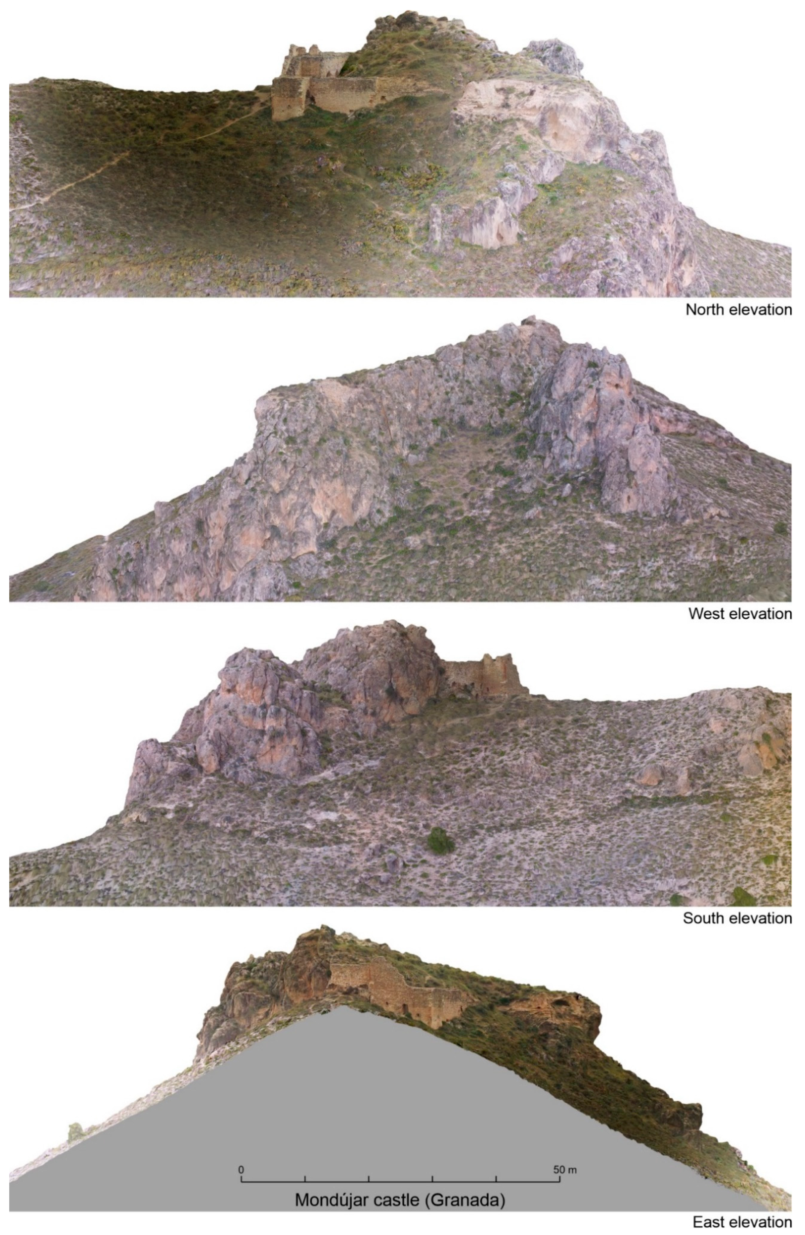
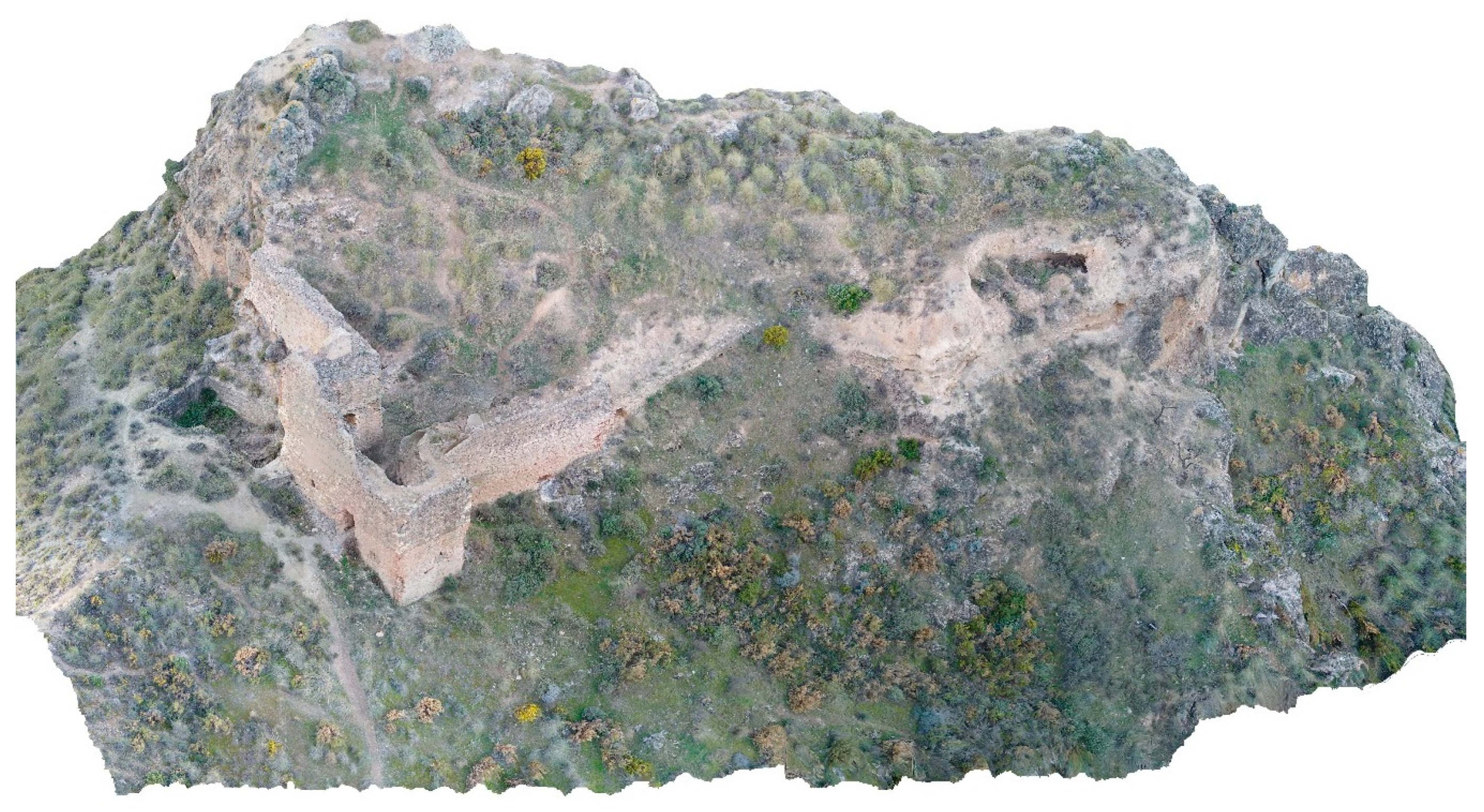
Based on the photographs taken with the drone, we constructed a general terrain elevation model and a digital mock-up of the castle (Figure 2 and Figure 3). With these 3D models and our on-site observations, we were able to develop a detailed description and conduct an architectural analysis of the remains of the castle. In addition, we tried to determine the relation between the written sources and the preserved walls.
The Andalusi fortress—now, for the most part, disappeared—presents an irregular plant adapted to the topography of the hill. Its ramparts were erected using masonry plinths held together with lime mortar. On top of them, rammed-earth walls were raised, made with gravel-joint of a small size, using small amounts of lime. These walls are mostly lost, perhaps due to their poor structural quality. In addition, the rammed-earth walls are not preserved, although their rubble and degraded materials are identifiable along the entire perimeter.
These remains of the original medieval construction are more evident in the middle of the northern side of the fortress. Here, debris of a tower showing both constructive techniques can still be appreciated. Masonry plinths are also present in the north-western corner of the castle, on its south-east side, in the highest part of its southernmost tip, and on both sides of a modern metal cross installed there in 1980.
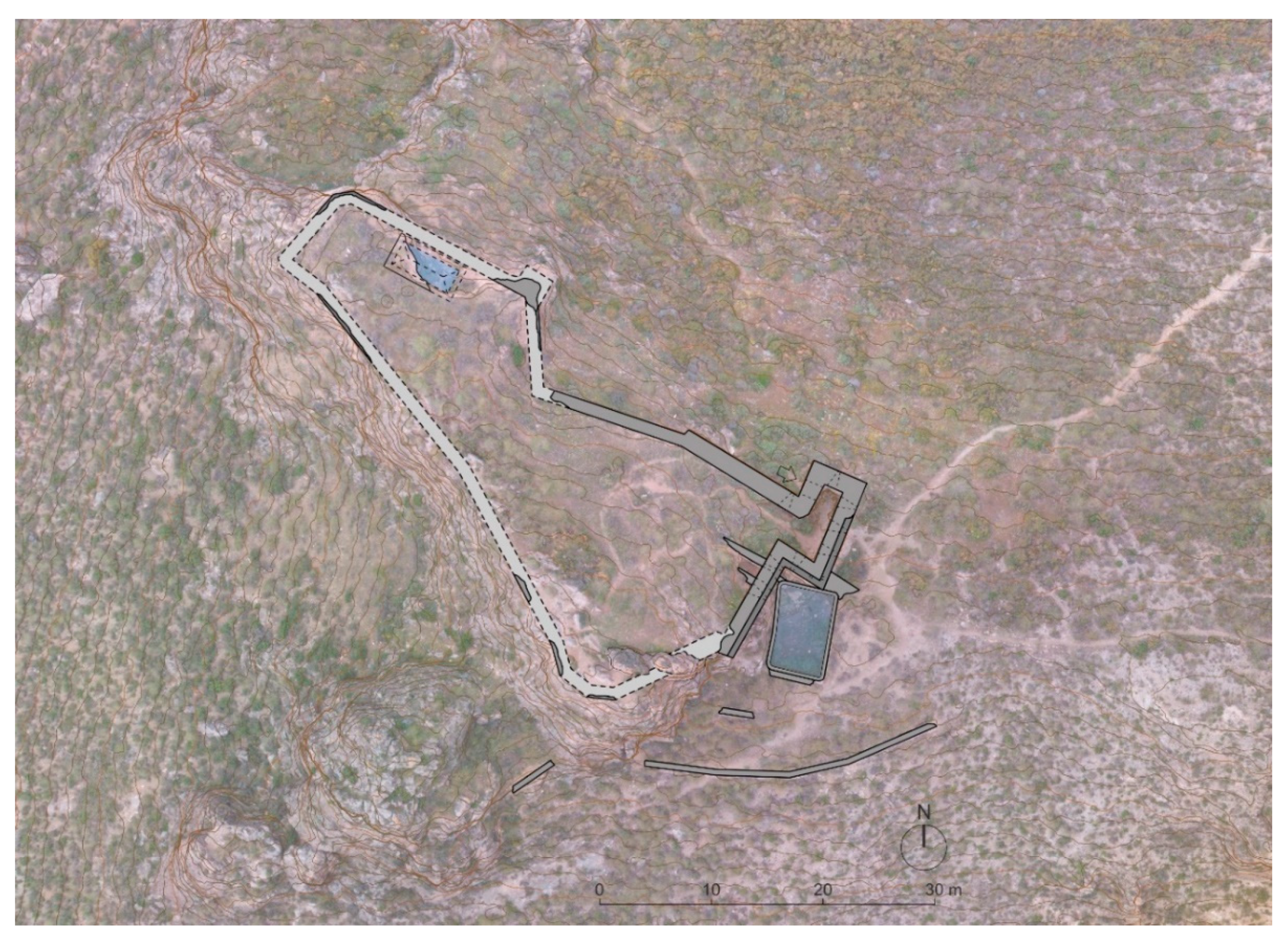
The interior of the complex is very irregular and its plot has a strong slope of 14 m. The whole fortress spans a measured area—including the walls—of 901 m2, using horizontal projection. The photogrammetric plan is overlaid on a zenithal orthophoto of the terrain, where the contour lines in one-metre intervals have been drawn to better appreciate the steep terrain of the hill (Figure 4). The area is full of rubble and contains remains of roof tiles and pottery chunks, some of which are glazed, honey-coloured and very thin—approx. 3 to 4 mm.
In the north-western corner, there are ruins of a rectangular cistern, measuring 5.65 × 2.30 m, which was covered with a masonry cloister vault. Currently, only the western third of the vault is still in place. This tank, once attached to the western end of the northern wall, could be measured in 1999. Years later, this part of the stronghold collapsed, ruining the cistern and its vault [8] (p. 294) (Figure 5).
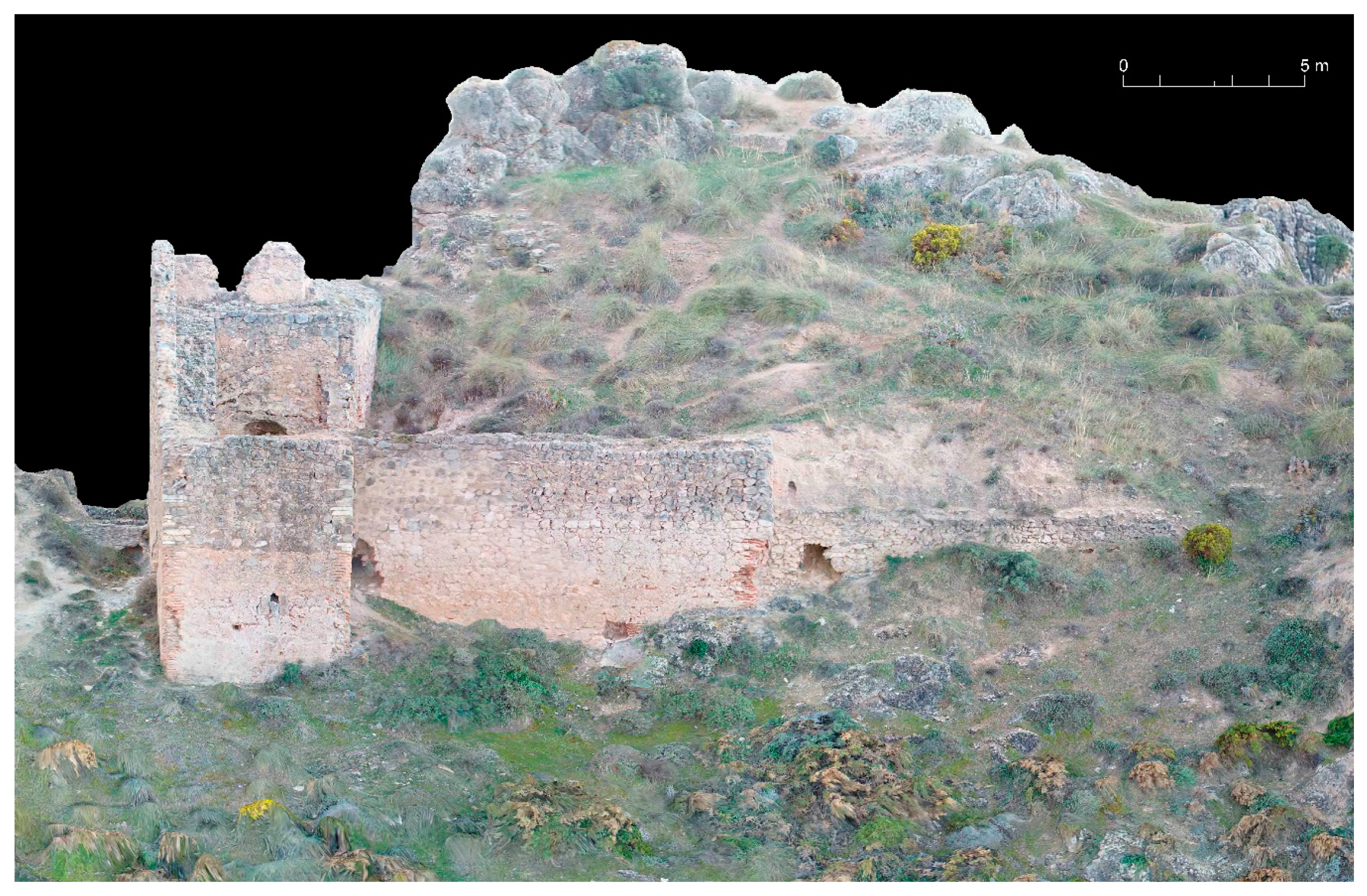
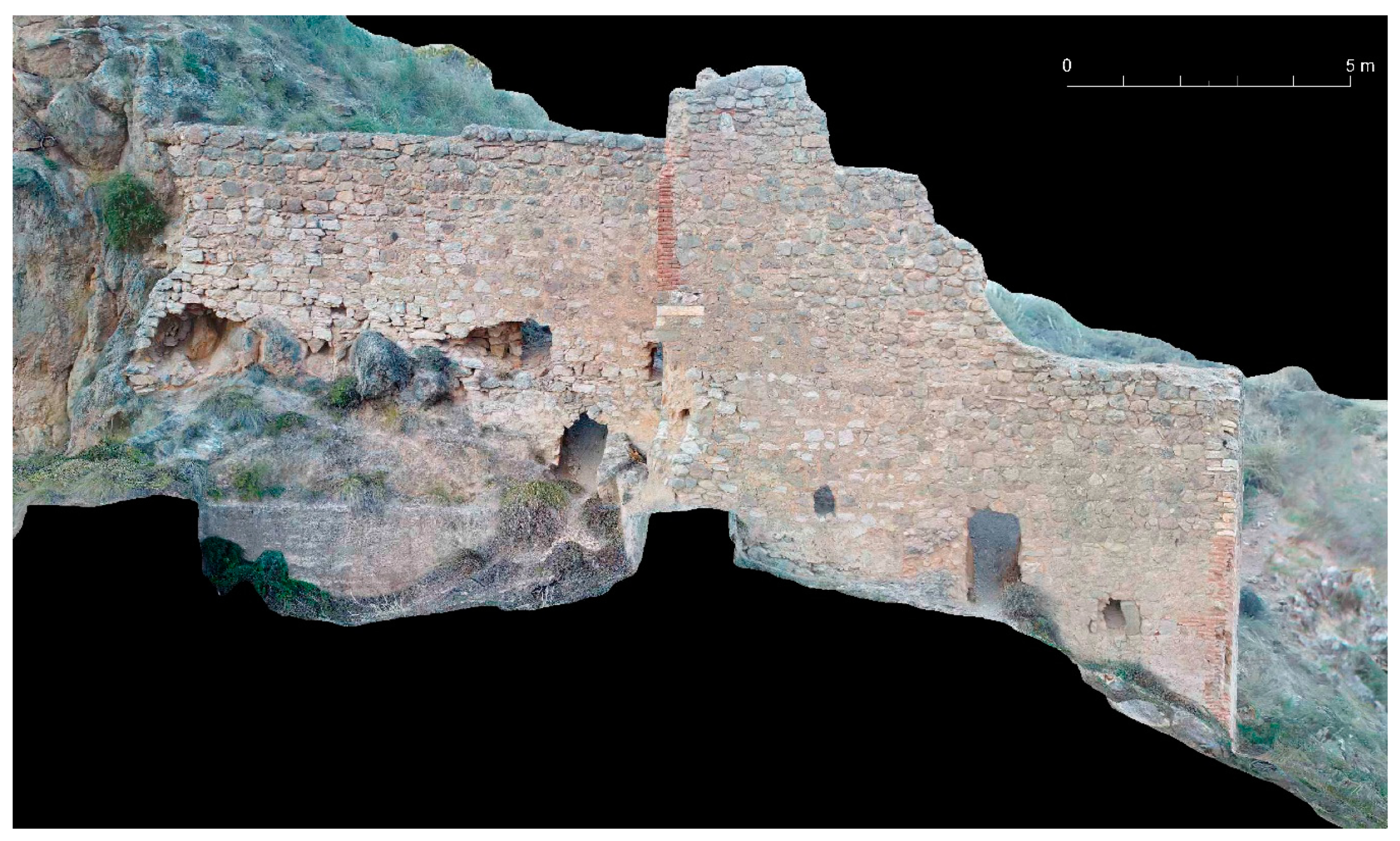
The vestiges of the Castilian fortress are the most evident at a first glance. In relation to these structures, it is evident that those works were minor compared to similar ones carried out in other castles and citadels of the Kingdom of Granada around the same time (Figure 6). They are in the north-eastern corner of the castle and consist of a tower gate with embrasures on several levels, measuring 5.17 m long on the northern side, 3.50 m on the western side (where the access gate is located), 10.36 m on the eastern side and 4.05 m to the south.
The northern side connects to the Andalusi fortress by means of a wall that is 11.40 m long and 1.65 m deep. Both wall sections meet using a small setback. This is very remarkable, as it can be observed that the Castilian wall, made entirely in masonry, covers the plinth of the Andalusi wall, as well as the remains of its rammed-earth section. From the entrance tower towards the south, a 10 m long and 1.70 m wide wall was built, with a 0.55 m wide defensive parapet.
Walls belonging to this stage were built with masonry, lime mortar, bricks and reused stone blocks in the corners. They present eight embrasures: One placed in the northern face; three in the eastern one; one on the southern side; one on the western side of the gate; and finally, two additional embrasures, placed in the eastern wall next to the outer cistern. The latter two are placed at a higher level to allow artillery firing over the cistern’s vault without harming it. All the embrasures are splayed towards the inside, with bricked jambs and timbrel vaults built with a double course of bricks. As is true throughout the castle, bricks have mostly been plundered. Holes in the embrasures were finished with stone blocks towards the outside, all of which have been plundered, except for the one on the northern side of the tower, which still maintains a couple of blocks. One of the sides of the most septentrional embrasure—in the eastern wall—is also preserved, showing a small firing-hole, likely to be oval-shaped, with a horizontal form. The entrance gate had jambs and a vault made of bricks, all of which have also been plundered (Figure 7 and Figure 8).
This tower gate maintains the parapet on the parapet walk, which is about 0.60 m wide, in its eastern and southern faces. Two arrow-holes pass through the wall; one on the oriental side—with lintels made of slate slabs—and the other on the meridional one, which is more deteriorated. The parapet walk was staggered on its eastern side, climbing towards the south; in fact, there are remains of six tall steps covered by slate slabs. The space within the tower gate is especially small, being 1.70 to 2.01 m wide and 6.65 m long. Two lines of putlog holes are visible in the inside walls for receiving frames of wooden beams at two levels, adapted to the terrain’s slope. In addition, there is a putlog placed in the south-east corner of the tower, made with bricks on the sides and on the top, and crossing from the inside to the outside through the diagonal of the cited corner. Another one is placed on the northern side of the tower, in an orthogonal direction.
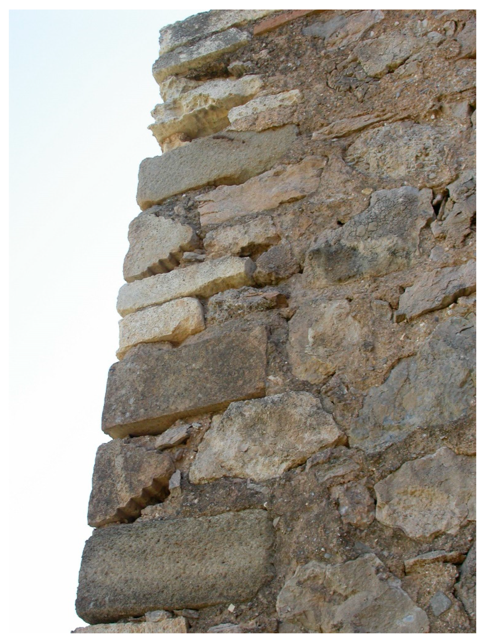
Two constructive stages can be observed in the east and north of the tower gate and in the northern wall, distinguished by the different colouring of the mortar holding the masonry. Corners are made with bricks at the bottom, but finished with stone blocks on the top, in addition to using stepped burial elements (called macabrillas, from the Arab term mqābrīya), and parts of Islamic tombstones reused as edge stone blocks. These two latter elements, typical of the funerary architecture, could likely have come from the very close Royal Nasrid Cemetery, moved to Mondújar by Boabdil in January 1492, when he left the Alhambra to set up his residence in the Lordship of Las Alpujarras, in Láujar de Andarax [27]. Three macabrillas are visible in the north-western corner of the tower gate, consisting of two made of grey stone and a cream-coloured one (Figure 9).
On the other hand, the north-eastern corner has one further macabrilla made of grey stone, and one grey-coloured tombstone fragment depicting geometric decorative patterns. Macabrillas were placed as stone blocks with a stepped shape to the inside, although their section is visible in the other direction of each corner.
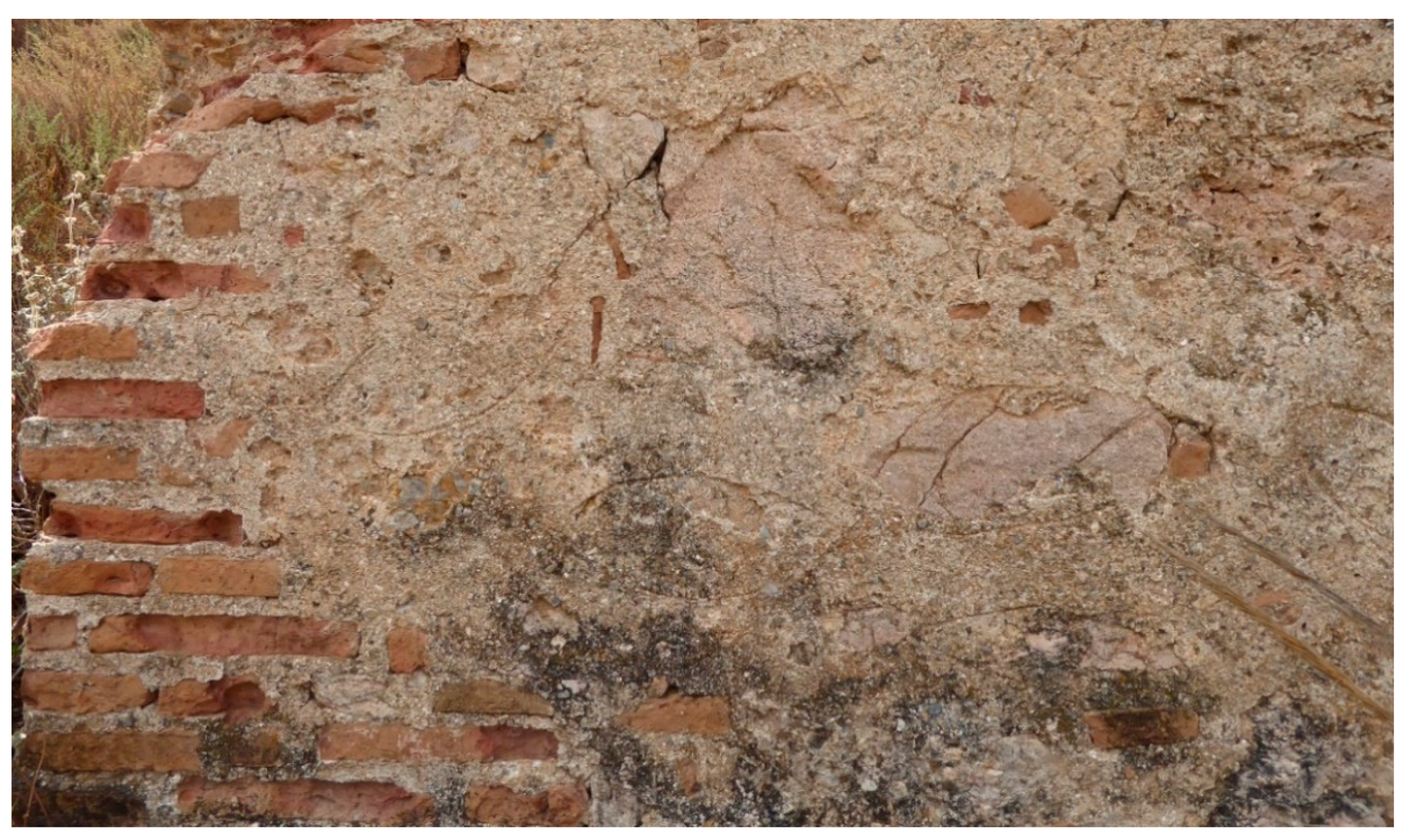
At the bottom of the northern side, there is lime mortar covering almost its entire surface. Placed over it, there are incised lines made of two curved lines, starting from the same point, and cutting at the other side, drawing fish-like shapes (Figure 10).
During the Castilian stage, the water supply and storage were notably improved by the construction of the outside cistern, to the east of the fortress. Its interior measurements are 7.47 m long, and between 4.54 and 4.70 m wide. It was built with lime concrete walls, and has rounded corners (except for one of them, which is chamfered). Its depth is over 2.50 m, although this cannot be more precisely measured due to the accumulation of rubble at the bottom. It might have been covered with a barrel vault, probably a low-rise one, made with stone slabs and bricked tympana, although only certain remains of these elements are preserved in the north-east corner and the eastern side. Given that its position is non-parallel to the Castilian part, and considering that the latter is partially built over it, this suggests that it could be of Andalusi origin. Nevertheless, the Castilian documentation from Contaduría Mayor de Cuentas, studied by J.A. Vilar-Sánchez [28], specifies that the Catholic Monarchs asked for several master cistern builders to come from Elche in 1492. Among these, one called El Valency would build the new cisterns for various fortresses in the Kingdom of Granada: Lanjarón, Mondújar (the one we are dealing with), Castell de Ferro, La Rábita, La Calahorra and those of the Alhambra. Therefore, we think that the Castilian cistern is the notably wide one built outside, while the one laid inside the fortress, of a smaller size, is the one built in the Andalusi period.
From the inside of the fortress, there is a passage—now open, but originally vaulted—that is 1.14 to 1.19 m wide, crossing under the eastern wall to safely reach the outside cistern, arriving at the northern point of the eastern side, so that people could gather water while being protected from the enemy.
Water would have reached this new cistern from the east through an intubated pipe whose remains extend for about 70 m, entering an artificial cliff of the hill descending in that direction [29]. The preserved remains correspond to the base of the conduction, forming a somewhat straight path. Before reaching the cited hill, a trapezoidal-shaped facility built with masonry is located, measuring 0.57 m on the north side, 0.55 m on the west side and 0.51 m on the south side, although in the east, there is no built wall; instead, the natural rock stands out of the ground. This facility could be a pen built at the same time as the conduction, given that the wall of the facility and the conduction are joined on its septentrional side.
The aforementioned cliff was shaped near the bottom of the rise coming from Sierra Nevada’s foothills. It results in a kind of artificial moat about 5–7 m wide, made by trimming the end of the rise. It has traversal walls—two to the north and two to the south—that could have been placed for a later development of agricultural terraces, as well as other walls parallel to the end of the rise on its southern side.
Towards the southern part of this cistern, there are remains of three badly preserved walls reasonably parallel, adapted to the slope of the hillside. Built with masonry held with mud mortar, they had an unknown purpose, which is difficult to know without an archaeological study, though they could be simple agricultural terraces.
With this precise 3D planimetry, we were able to measure the dimensions of the masonry walls, as well as figure out the amount of building work carried out, and then compare this information with the documental data introduced in the first section of the paper (Figure 11).
To calculate the area and volume of the building works, we considered the Castilian or Burgos’ vara, representing the old measurement yardstick at that time. The equivalence of this Castilian vara was approx. 0.84 m, and it could be divided into three feet (0.28 m for each one) or into four palms of 0.21 m. Likewise, it should be taken into account that in the early sixteenth century, the term tapia real could refer to both an area and a volume measurement [30]. As stated above, the dimensions of the erected tapias reales were five palms high, 10 long and six palms wide, which, in the metric system, is around 1.05 × 2.10 × 1.21 m, respectively. Hence, each constructed tapia real for the castle wall was equivalent to 2.20 m2 in elevation and 2.67 m3 in volume.
The stonemason Pedro Ruys made 49 tapias reales that, together with the 149 built by the stonemasons Alonso Jurado and Juan Meneses, amounted to 191 tapias reales (equal to 420 m2 and 509 m3). Nevertheless, today, the preserved masonry rampart, including its crenellated parapets, has the dimension of 330 m2 and a volume of 408 m3. Therefore, around 90 m2 and 101 m3 are missing and were probably used to build the covered passage that provides access to the outside cistern, the wall protecting its north-east corner and other minor works made within the castle. Those works were presumably hidden under the large amount of rubble present in the lower part of the complex.
We should also point out that the documents related to the payments made to Alonso Jurado and Juan Meneses said that the thickness of their tapias reales was six palms and the price for each one was 550 maravedís. However, with respect to the walls erected by Pedro Ruys, the documents only said that they were like those made for the Lanjarón stronghold, and that he received 660 maravedís for each tapia real. Nonetheless, in the description of his works in Lanjarón, there are no references to the dimensions of the masonry walls he built, so we do not have enough data to justify why the prices paid were so different [22].
Furthermore, we can approximately provide the date when the vault and the northern wall of the Andalusi cistern (the one located within the castle) collapsed (Figure 5). This water tank was measured and described by both A. Malpica in 1996 [7] (p. 292) and M. Martín in 1999 [8] (p. 294). During our first visit to the castle (11 April 2005), we saw it mainly ruined; therefore, its destruction must have happened between 1999 and early 2005.
4. Discussion
The Andalusi strongholds of Mondújar and Lanjarón were refortified after the Mudéjar revolt (which started at the end of 1499). The purpose of those works was to improve the quality of their defence, as well as their adaptation to the use of artillery. The building works consisted of defensive walls made in masonry with a rich lime mortar. Nevertheless, the design of these fortifications—in the charge of stonemasons settled in Granada—was not at the edge of the military engineering of that moment. The works conducted in both castles did not achieve the quality of the designs that the Grand Master principal artilleryman Ramiro López made for Salobreña (1490) and Santa Fe (1500), as well as for the Alhambra, Almuñécar, and other artillery adaptations developed in castles all around the Kingdom of Granada between 1492 and 1495 [31].
In both fortresses, defensive capabilities when using artillery were very limited: The structures of these castles only allowed the use of small-calibre weapons, and both constructions were located on very steep emplacements. Specifically, in Mondújar, there were only eight embrasures, while in Lanjarón, there were five. All of these are splayed embrasures covered by a small low-rise vault with a semi-conic shape. Outside the castles, the embrasures were protected by one or several stone blocks in which the firing holes were carved. In Mondújar, there are still vestiges of these stone blocks in two embrasures, but their poor conservation does not allow it to be established how those firing holes were shaped. However, in Lanjarón, the southwestern sector of the complex is well preserved and the firing holes are of the type cruz y orbe, since they present a round hole with a cross over it.
Lanjarón Castle was subject to archaeological excavations and, after them, it was restored under the supervision of the architect Salvador Algarra between the years 2007 and 2008. The works were funded by the local council and the Spanish Ministry of Development, thanks to the so-called “1% Cultural” programme. On the contrary, the fortress of Mondújar has not received any kind of works yet, for excavation, consolidation or appreciation of its heritage value.
In this respect, we would like to highlight that the path departing from the centre of Mondújar to the fortress is difficult to follow and in its last third, it passes through a private olive plantation. In the same way, the last part of the trail is very difficult to walk along because of the strong slope of the hill and its natural trail surface, without any kind of pavement. Hence, a first step to achieving a real cultural appraisal of this place must include a thorough improvement of the trail, involving enhancement of the route, especially in its final stretch, and correct signage.
Without a doubt, the stronghold of Mondújar presents a remarkable historical, cultural and architectural relevance, together with an attractive landscape. Nevertheless, the institutional efforts to improve and recover this regional landmark are, at the moment, insufficient and not always based on scientific knowledge. In fact, the official historical information provided for this place on the webpage of the Council of Lecrín is mainly about the Romantic legend, stating that the castle was a wedding gift given by Muley Hacén to his second wife, Zoraya [32]. The same statement is repeated by the most important touristic association of the Valle de Lecrín (Granada Rural Sur), whose webpage catalogues the fortress as a stately house, remarking again that the building was Zoraya’s wedding present [33]. These, among other examples of misinterpretation, have produced popularisation of the misnomer “Castillo de Zoraya” (Zoraya’s Castle), which has even predated the original toponym in official cartography issued by the ministerial agencies [34], or the Spanish Electrical Network [35]. The conscious spreading of the mythical legend instead of its heritage valorisation has even resulted in the placement of a sculpture in honour of Zoraya in Talará (one of the villages part of Lecrín).
In addition to the very recent legendary tales that have shaped the current knowledge and appreciation of the monument, we would like to remark that the castle has enough cultural, historical and architectural singularities that make it unique. It is known that, in Granada, during the first years of the sixteenth century, the use of Islamic tombstones as building materials in Catholic religious or military places was quite common. This was possible after the Catholic Monarchs’ Royal Decree of 20 September 1500, which put an end to the Muslim cemeteries of Granada [36]. Among the Catholic works using these burial elements, the church of San Cristóbal, in the old neighbourhood of Albaicín, is a notable example. Within the military works, we can highlight the stone blocks, originally tombstone borders, used as reinforcement of the wall ranging from the Gate of the Justice to the Royal Gate in the Alhambra. One of the most significant details of Mondújar Castle, making it a unique piece, is that it is the only documented place where the use of several stepped macabrillas, together with a stone block with geometric patterns, can be found.
The dissemination of this monument is based on photographs, which can only record its Castilian phase. We shall propose to competent institutions the use of 3D models for dissemination of the heritage value of the castle to the public. As an example, the model that we prepared can be used to appreciate all the values of the two phases of the fortification (Nasrid and Castilian).
5. Conclusions
Mondújar Castle was the protagonist in the periods of war that occurred in 1500. In the same manner, a collection of Romantic legends related to this castle, taking place before the Capitulation of Granada (1492), emerged in the 19th century. With the photographical, planimetric and descriptive documentation presented in this work, those stories can be automatically refuted: The lack of space and the slope within the stronghold make the existence of hypothetical palaces and gardens that could have been enjoyed by Muley Hacén and Zoraya physically impossible.
The state of conservation of the castle is rather worrying. In addition to the usual historic plundering, we would like to note the collapse of part of the Andalusi wall on the northern side, which has also affected part of the cistern next to it. The remains of wall elevations and the tower in that sector, built with weak rammed-earth materials, are inexorably disappearing. Furthermore, we would like to point out the appearance of spray paint damage on the interior walls of the Castilian tower gate.
Therefore, in our opinion, there is an urgent need to perform archaeological works and to develop a conservation and restoration project to stop the natural and anthropic deterioration of the monument. In this way, Mondújar Castle, together with the one in Lanjarón (now already recovered), could be integrated within a circuit of cultural visits of the regions of Valle de Lecrín and the Alpujarras, thus contributing to the sustainable development of these territories.
Author Contributions
Conceptualization, A.O. and M.A.M.-F.; methodology, A.O. and M.A.M.-F.; investigation, A.O. and M.A.M.-F.; resources, M.A.M.-F.; drawings, A.O.; writing—original draft preparation, A.O. and M.A.M.-F.; writing—review and editing, A.O. and M.A.M.-F. All authors have read and agreed to the published version of the manuscript.
Funding
We acknowledge support of the publication fee by the CSIC Open Access Publication Support Initiative through its Unit of Information Resources for Research (URICI).
Acknowledgments
We would like to thank the researchers of the School of Arabic Studies (CSIC), Antonio Almagro-Gorbea and Luis J. García-Pulido, for their important collaboration in taking the pictures using a drone (May and October, 2016). In the same manner, they helped us in the treatment of these photographs with Agisoft PhotoScan Professional. Moreover, we would like to thank the technicians of the same institution, Víctor Martín-Madrid and Marta Rivera-Alonso, for their participation in the elaboration of the planimetry and virtual pictures included in this paper.
Conflicts of Interest
The authors declare no conflict of interest.
References
- Instituto Nacional de Estadística (INE). Available online: http://www.ine.es/nomen2/index.do (accessed on 7 September 2020).
- Guía Digital del Patrimonio Cultural de Andalucía. Available online: https://guiadigital.iaph.es/bien/inmueble/22143/granada/Lecrín/castillo-de-Mondújar (accessed on 11 June 2019).
- Seco de Lucena-Paredes, L. Topónimos Árabes Identificados; Universidad de Granada: Granada, Spain, 1974; p. 62. [Google Scholar]
- Martínez-Ruiz, J. El Lenguaje del Suelo (Toponimia); Universidad de Jaén: Jaén, Spain, 2002; p. 665. [Google Scholar]
- García del Moral-Garrido, M.T. Nueva Contribución al Estudio de los Nombres del Lugar del Mediodía hispánico: El municipio de Lecrín (Acequias, Béznar, Chite, Mondújar, Murchas y Talará), de la Comarca del Valle de Lecrín (Granada). Ph.D. Thesis, Universidad de Sevilla, Seville, Spain, 22 January 2010; pp. 541–545. [Google Scholar]
- Moyano, I.T.; Granados, J.A.G.; Eguaras, A.M.; Cuenca, V.S.; Sánchez, E.M.J. Las termas romanas de Lecrín (Granada). Avance de la 1ª campaña. In Proceedings of the XVII Congreso Nacional de Arqueología, Logroño, Spain, 14–16 September 1983; pp. 897–902. [Google Scholar]
- Malpica-Cuello, A. Poblamiento y Castillos en Granada; Fundación El Legado Andalusí: Granada/Barcelona, Spain, 1996; pp. 156–157, 291–292. [Google Scholar]
- Martin-García, M.; Bleda-Portero, J.; Martín-Civantos, J.M. Inventario de Arquitectura Militar de la Provincia de Granada (siglos VIII al XVIII); Diputación de Granada: Granada, Spain, 1999; pp. 292–294. [Google Scholar]
- Molina-Fajardo, M.A. El espacio Rural Granadino Tras la Conquista Castellana: Urbanismo y Arquitectura Con Funciones Residenciales del Valle de Lecrín en el siglo XVI. Ph.D. Thesis, Universidad de Granada, Granada, Spain, 16 April 2012; pp. 934–955. Available online: https://digibug.ugr.es/handle/10481/21760 (accessed on 8 September 2020).
- López-Rodríguez, M.A. Las Parroquias de la Diócesis de Granada (1501-2001); Arzobispado de Granada: Granada, Spain, 2002; p. 339. [Google Scholar]
- Relaciones de los habices del reino de Granada que hay en las tahas de: Valle de Lecrín; Ferreira y Poqueira; “Zuheal”; “Subiles”; Ugijar; Berja; Dalías; “Andarax”; “Luchar”; Alboloduy; Almuñecar, Motril y Salobreña, 1501; Archivo General de Simancas (AGS), Contaduría Mayor de Cuentas (CMC), 1ª época, leg. 131.
- Libros de Población del Reino de Granada, 1572; Archivo Histórico Provincial de Granada (AHPGr), Libro de Mondújar_6748, p. 9v.
- Gómez-Moreno Martínez, M. El cementerio real de los nazaríes en Mondújar. Al-Andalus 1942, VII, 269–281. [Google Scholar]
- Albarracín-Navarro, J. Un documento granadino sobre los bienes de la mujer de Boabdil en Mondújar. In Actas del I Congreso de Historia de Andalucía, Diciembre, 1976. Andalucía Medieval; Cajasur, Obra Social y Cultural: Córdoba, Spain, 1978; pp. 339–348. [Google Scholar]
- Villa-Real, F.P. El Castillo de Mondújar. El Liceo Granada 1874, 6, 123–156. [Google Scholar]
- Gómez-Moreno González, M. Defensa del Castillo de Mondújar por Doña Guiomar de Acuña. El Liceo Granada 1875, 10, 145–148. [Google Scholar]
- Del Mármol-Carvajal, L. Historia del Rebelión y Castigo de los Moriscos del Reyno de Granada, 2nd ed.; Imprenta de Sancha: Madrid, España, 1797; pp. 56–64. [Google Scholar]
- Ladero-Quesada, M.Á. Granada Después de la Conquista: Repobladores y Mudéjares; Diputación Provincial: Granada, Spain, 1993; p. 261. [Google Scholar]
- Tenencia de la fortaleza de Mondújar, 1494-1607; AGS, Contaduría Mayor del Sueldo, 2ª época, leg. 374-2.
- Cédula sobre la Fortaleza de Monduxa, AGS, Cámara de Castilla (CaCa.), Cédulas, Libro 1, p. 34.
- Vilar-Sánchez, J.A. 1492–1592, Una Década Fraudulenta. Historia del Reino Cristiano de Granada Desde su Fundación, Hasta la Muerte de la Reina Isabel la Católica; Alhulia: Granada, Spain, 2004; p. 450. [Google Scholar]
- Vilar-Sánchez, J.A. (Ed.) Pagos hechos a Pedro de Rojas para las fortalezas de Adra, Castell, Albuñol, Salobreña, Lanjarón y Mondújar, 1500; AGS, C.M.C., leg. 1282, doc. 15. This document was consulted. In Los Reyes Católicos en la Alhambra. Documentación Archivística (CD); Patronato de la Alhambra: Granada, Spain, 2008; pp. 740–752. [Google Scholar]
- López, T. Diccionario Geográfico de Andalucía: Granada; Segura-Graiño, C., De Miguel, J.C., Eds.; Editorial Don Quijote: Granada, Spain, 1990; p. 157. [Google Scholar]
- Archivo Histórico Provincial de Granada. El Catastro del Marqués de la Ensenada en el Antiguo Reino de Granada. Instrumentos de descripción 16; Consejería de Cultura Junta de Andalucía: Sevilla, Spain, 2004. [Google Scholar]
- Madoz-Ibáñez, P. Diccionario Geográfico-Estadístico-Histórico de España y Sus Posesiones de Ultramar vol. 11; Imprenta del Diccionario Geográfico: Madrid, Spain, 1848; p. 495. [Google Scholar]
- Almagro, A.; Orihuela, A. Métodos para documentar y restaurar zonas de difícil acceso en el castillo de Salobreña (Granada). In Modern Age Fortifications of the Western Mediterranean Coast; Rodríguez-Navarro, P., Ed.; Universitat Politècnica de València: Valencia, Spain, 2015; pp. 287–290. [Google Scholar]
- Rodríguez-Aguilera, A.; Bordes-García, S.; Quero-Endrino, F. El programa de medidas correctoras de impacto arqueológico de la autovía Bailen_Motril. Tramo Dúrcal-Ízbor. Bibataubín 2001, 2, 33–41. [Google Scholar]
- Vilar-Sánchez, J.A. Las Casas Reales de la Alhambra en los Inicios de su Incorporación a la Corona de Castilla. Una Síntesis Cultural. Conferencia leída en Granada el 15/09/2008. p. 32. Available online: https://www.academia.edu/39749333/Las_Casas_Reales_de_la_Alhambra_en_los_inicios_de_su_incorporaci%C3%B3n_a_la_corona_de_Castilla (accessed on 30 September 2020).
- García-Pulido, L.J.; Peñalver-Martín, S. The Most Advanced Hydraulic Techniques for Water Supply at the Fortresses in the Last Period of Al-Andalus (Thirteenth to Fifteenth Century). Arts 2019, 8, 63. [Google Scholar] [CrossRef] [Green Version]
- Graciani-García, A. Consideraciones iniciales y reflexiones sobre la tapia como unidad de medida para una interpretación constructiva del término. In Actas del Octavo Congreso Nacional de Historia de la Construcción; Huerta, S., López-Ulloa, F., Eds.; Instituto Juan de Herrera: Madrid, Spain, 2013; Volumen I, pp. 439–446. [Google Scholar]
- García-Pulido, L.J.; Orihuela, A. Nuevas aportaciones sobre las murallas y el sistema defensivo de Santa Fe (Granada). Arch. Español Arte 2005, LXXVIII, 23–43. [Google Scholar]
- Ayuntamiento de Lecrín. Available online: http://nuevo.eslecrin.es/mondujar (accessed on 22 November 2020).
- Valle de Lecrín Turismo. Available online: https://turismovalledelecrin.com/castillo-de-mondujar/ (accessed on 22 November 2020).
- SICA, Sistema de Información sobre Contaminación Acústica, Ministerio de Transición Ecológica (Information System for Acoustic Contamination, Ministry for Ecological Transition). Study on A-44 motorway, Bailén (Jaén)—Lecrín (Granada), Map of Affected Areas. Available online: http://sicaweb.cedex.es/docs/mapas/fase1/carretera/Estado_BailenMotril/A-44/Carretera_Estado_BailenMotril_A-44_SICA_Ltarde.pdf (accessed on 22 November 2020).
- Public Consultation for Electrical Line Saleres-Gabias/Órgiva, Spanish Electrical Network. 2013. Available online: https://www.juntadeandalucia.es/export/drupaljda/tramite_informacion_publica/18/09/13752-AT%20PE_ES_SALRES_LGABIAS_ORGIVA%20planta%20general.pdf (accessed on 22 November 2020).
- Torres-Balbás, L. Cementerios hispanomusulmanes. Al-Andal. 1957, XXII, 131–191. [Google Scholar]
Figure 1.
Location of Mondújar, its castle, and the former Royal Islamic Cemetery. The dotted line represents the 1.2 km trail from the village church to the castle.
Figure 1.
Location of Mondújar, its castle, and the former Royal Islamic Cemetery. The dotted line represents the 1.2 km trail from the village church to the castle.

Figure 2.
Orthophotos obtained from a 3D general terrain elevation model of Mondújar Castle, taken from the four points of the compass (Antonio Orihuela; Víctor Martín-Madrid, 2020).
Figure 2.
Orthophotos obtained from a 3D general terrain elevation model of Mondújar Castle, taken from the four points of the compass (Antonio Orihuela; Víctor Martín-Madrid, 2020).

Figure 3.
3D general terrain elevation model of Mondújar Castle, as of 2016 (Antonio Orihuela; Víctor Martín-Madrid, 2020).
Figure 3.
3D general terrain elevation model of Mondújar Castle, as of 2016 (Antonio Orihuela; Víctor Martín-Madrid, 2020).

Figure 4.
Plan of Mondújar Castle. The dark grey parts correspond to the structures preserved, and the light grey ones are the parts that have disappeared. We also present the outside cistern, the vestiges of the interior one and walls of the exterior terraces (A. Orihuela; V. Martín-Madrid, 2020).
Figure 4.
Plan of Mondújar Castle. The dark grey parts correspond to the structures preserved, and the light grey ones are the parts that have disappeared. We also present the outside cistern, the vestiges of the interior one and walls of the exterior terraces (A. Orihuela; V. Martín-Madrid, 2020).

Figure 5.
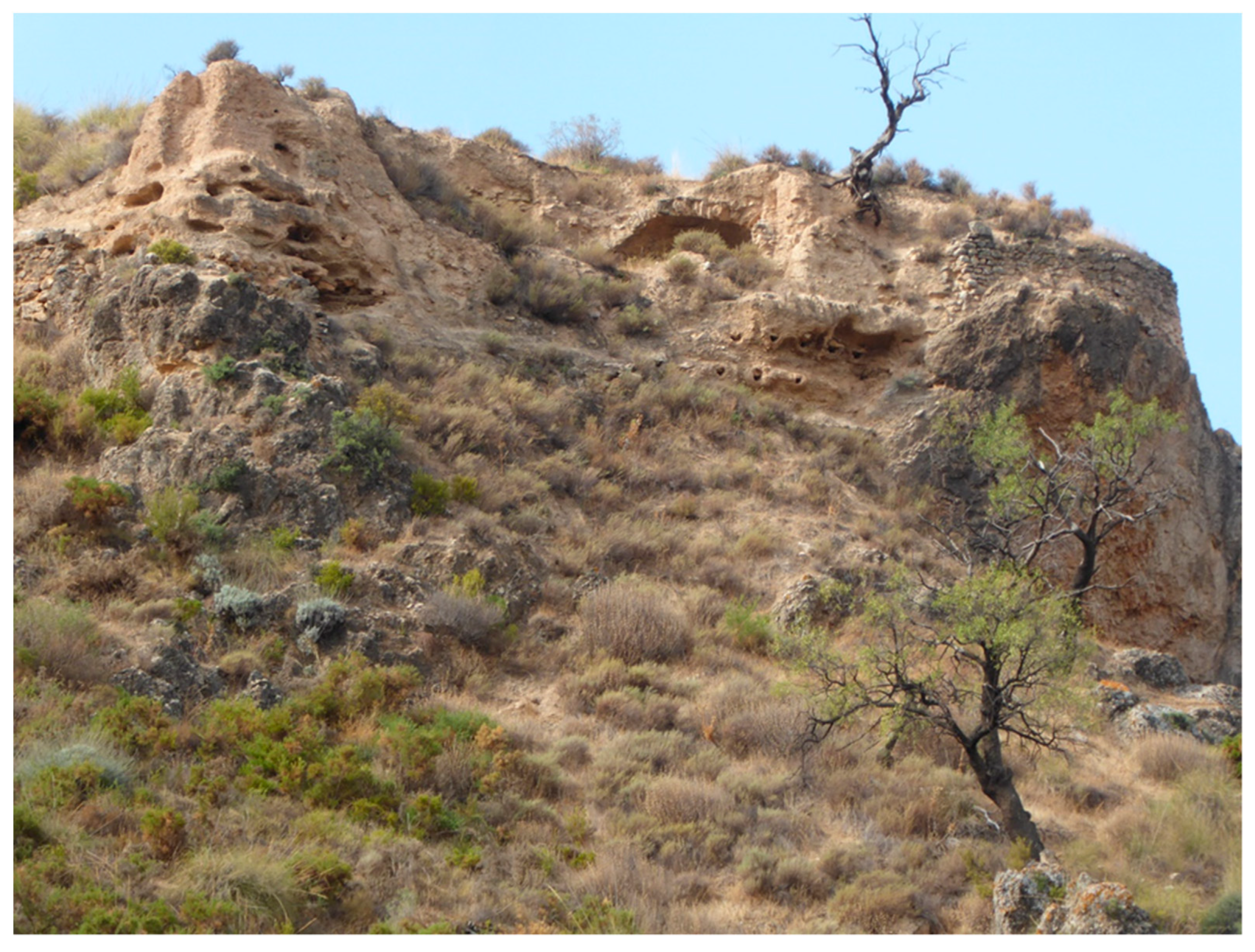
Exterior view of the north-western sector of the wall, Mondújar Castle. From this point, we can appreciate (on the left) the remains of the core of a rammed-earth tower and the ruins of the vault of the Andalusi cistern (in the middle), as well as the masonry plinth of the wall, to the right (A. Orihuela, 2020).
Figure 5.
Exterior view of the north-western sector of the wall, Mondújar Castle. From this point, we can appreciate (on the left) the remains of the core of a rammed-earth tower and the ruins of the vault of the Andalusi cistern (in the middle), as well as the masonry plinth of the wall, to the right (A. Orihuela, 2020).

Figure 6.
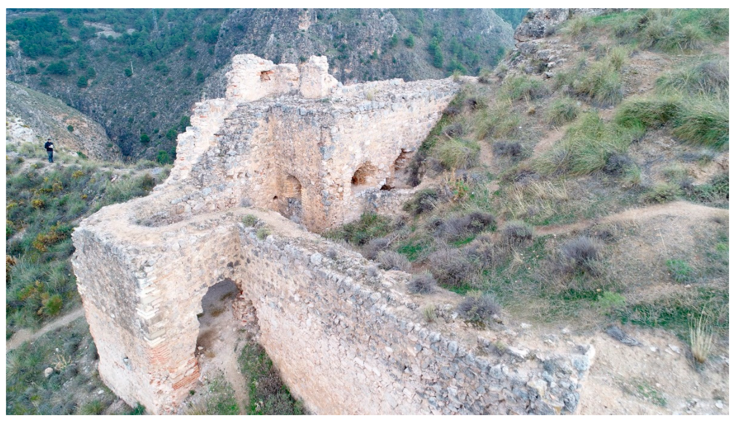
Photo of the Castilian fortification, taken by a drone (Luis J. García-Pulido, 2016).

Figure 7.
Orthophoto of the east elevation of the Castilian fortress, Mondújar Castle (Antonio Orihuela; Víctor Martín-Madrid, 2020).
Figure 7.
Orthophoto of the east elevation of the Castilian fortress, Mondújar Castle (Antonio Orihuela; Víctor Martín-Madrid, 2020).

Figure 8.
Orthophoto of the north elevation of the Castilian fortress, Mondújar Castle (Antonio Orihuela; Víctor Martín-Madrid, 2020).
Figure 8.
Orthophoto of the north elevation of the Castilian fortress, Mondújar Castle (Antonio Orihuela; Víctor Martín-Madrid, 2020).

Figure 9.
North-western corner of the tower gate, Mondújar Castle. In this picture, the stepped macabrillas can be appreciated (Antonio Orihuela, 2005).
Figure 9.
North-western corner of the tower gate, Mondújar Castle. In this picture, the stepped macabrillas can be appreciated (Antonio Orihuela, 2005).

Figure 10.
North side of the tower gate, Mondújar Castle. In this picture, the fish-like incised lines, made on the lime mortar plastering, can be appreciated (Antonio Orihuela, 2020).
Figure 10.
North side of the tower gate, Mondújar Castle. In this picture, the fish-like incised lines, made on the lime mortar plastering, can be appreciated (Antonio Orihuela, 2020).

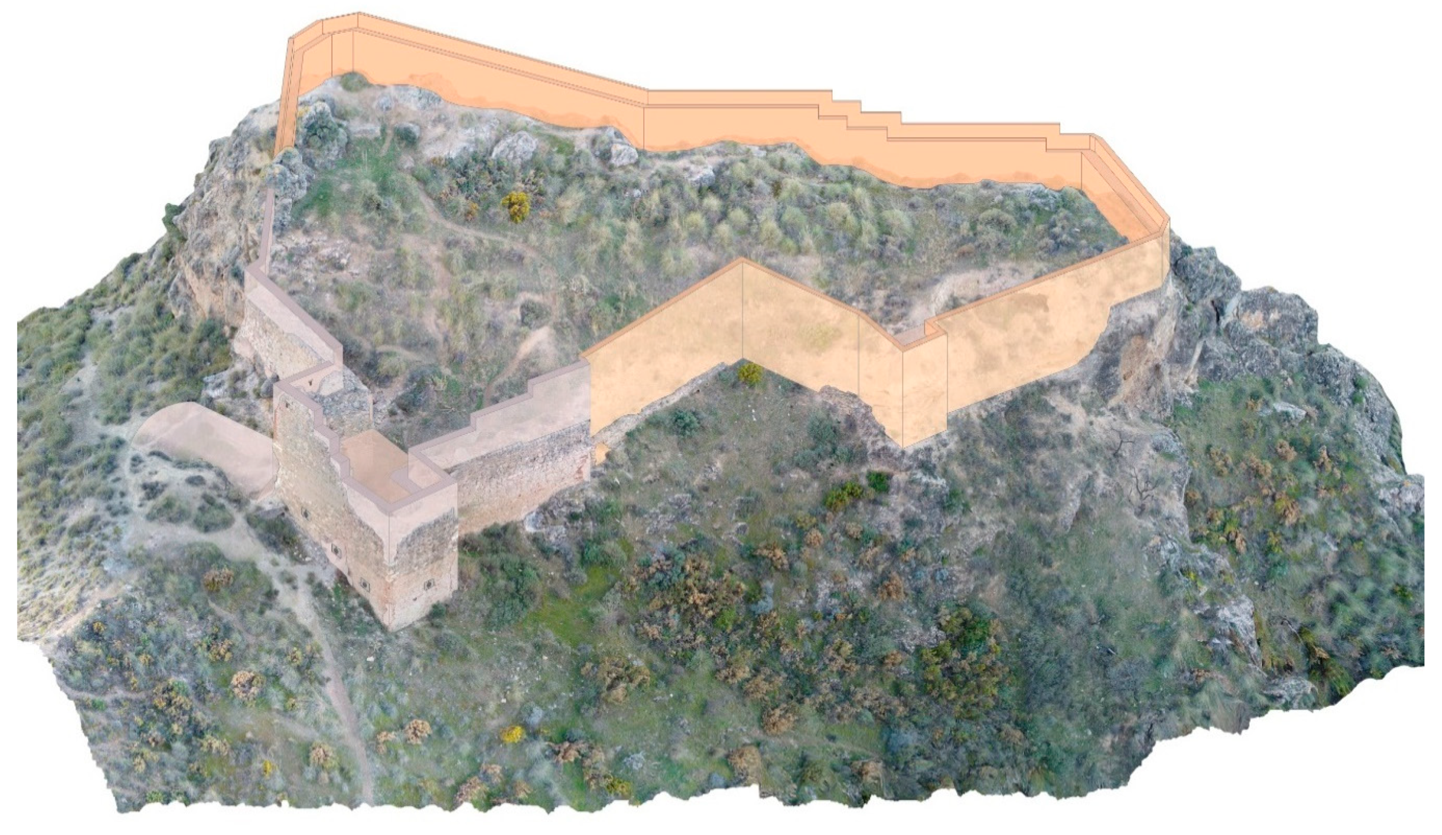
Figure 11.
3D digital mock-up of Mondújar Castle presenting our proposal of reconstruction of the ramparts (battlements not included). The Andalusi fortress has been drawn in ochre colour and the Castilian part in grey (Antonio Orihuela; Víctor Martín-Madrid, 2020).
Figure 11.
3D digital mock-up of Mondújar Castle presenting our proposal of reconstruction of the ramparts (battlements not included). The Andalusi fortress has been drawn in ochre colour and the Castilian part in grey (Antonio Orihuela; Víctor Martín-Madrid, 2020).


Table 1.
Mondújar Castle’s alcaides.
| Alcaides | Date |
|---|---|
| Sancho Deyo | First years after the Conquest |
| Pedro de Zafra | 30 April 1494 |
| Francisco de Zafra or de Alarcón | 9 April 1500 |
| Francisco Carrillo de Guzmán, Leonor de Alarcón’s husband | 8 November 1543 |
| Charles de Zuñiga | 1550 |
| Pedro de Reinoso | 7 November 1566 |
| María de Reinoso, (Pedro de Reinoso’s unmarried daughter), her uncle Juan de Enao | 1576–1578 |
| Pedro de Velasco, María de Reinoso’s husband (deceased 1604) | 26 March 1580 |
Data from Miguel Ángel Ladero Quesada, A.G.S., C.M.S. 2ª época, leg. 374-2 and Ca.Ca., Cédulas, Libro 1, p. 34.
Publisher’s Note: MDPI stays neutral with regard to jurisdictional claims in published maps and institutional affiliations. |
© 2020 by the authors. Licensee MDPI, Basel, Switzerland. This article is an open access article distributed under the terms and conditions of the Creative Commons Attribution (CC BY) license (http://creativecommons.org/licenses/by/4.0/).
Share and Cite
MDPI and ACS Style
Orihuela, A.; Molina-Fajardo, M.A. UAV Photogrammetry Surveying for Sustainable Conservation: The Case of Mondújar Castle (Granada, Spain). Sustainability 2021, 13, 24. https://0-doi-org.brum.beds.ac.uk/10.3390/su13010024
AMA Style
Orihuela A, Molina-Fajardo MA. UAV Photogrammetry Surveying for Sustainable Conservation: The Case of Mondújar Castle (Granada, Spain). Sustainability. 2021; 13(1):24. https://0-doi-org.brum.beds.ac.uk/10.3390/su13010024
Chicago/Turabian StyleOrihuela, Antonio, and María Aurora Molina-Fajardo. 2021. "UAV Photogrammetry Surveying for Sustainable Conservation: The Case of Mondújar Castle (Granada, Spain)" Sustainability 13, no. 1: 24. https://0-doi-org.brum.beds.ac.uk/10.3390/su13010024
Note that from the first issue of 2016, this journal uses article numbers instead of page numbers. See further details here.