1. Introduction
Since early human settlement, coastal regions around the world have always attracted people due to their abundance of marine food resources, a more favorable climate, coastal lowlands to develop agriculture and urbanization, and, certainly, better trade opportunities [
1]. The millennial presence of human coastal settlements has left tangible and intangible cultural and material traces, which are now a fundamental part of the cultural heritage of coastal populations. Because of the importance of both natural and cultural heritage along the coastline, the European Union has ratified the Protocol on Integrated Coastal Zone Management (ICZM) in the Mediterranean. Several studies about ICZM have been recently proposed in the literature. For example, Barragán and Lazo [
2] tried to update and synthesize the current body of knowledge on ICZM in Peru. Kies et al. [
3] described participatory approaches that should be involved to support the implementation of the Marine Strategy Framework Directive to manage the Mediterranean resources. In continental Ecuador and the Galapagos Islands, ICZM has been analyzed from the perspective of tourism, presenting its strengths, weaknesses, opportunities, and threats [
4]. Milanés Batista et al. [
5] designed a new methodology incorporating public participation and environmental energy planning tools in the stages of an ICZM program in Cuba. The role of stakeholders in Integrated Coastal Zone Management in Kavala and Heraklion in Greece was analyzed by Niavis et al. [
6]. The ICZM Protocol was signed by numerous Mediterranean countries in 2008, and constitutes the first legal instrument of its kind aimed at restoring, preserving, and sustaining landscape, natural resources, and cultural heritage, as well as promoting social and economic sustainable development [
7]. Indeed, the protocol actively seeks to enhance the sustainable development of coastal zones, by ensuring that the environment and the landscapes benefit from the economic, social, and cultural development of an area for the present and future advancement of local populations. By signing the protocol, all the contracting parties will have to implement rigorous measures for the protection, appreciation, and promotion of the cultural heritage of coastal zones in compliance with national and international policies [
8]. Unfortunately, except for some local approaches [
9], so far, countries have failed to achieve the integrated management of coastal zones and cultural heritage envisioned by the ICZM Protocol. In effect, both the Final Declaration of the Conference of Human Environment issued by the United Nations in Stockholm in 1972 and the Declaration of the Earth Summit of Rio de Janeiro in 1992 presciently tried to promote a combined management model. In fact, already in the 1970s, with the Mediterranean Action Plan signed in Barcelona by 21 European Mediterranean countries [
10], there were talks of joint action to preserve fragile coasts and heritage sites located nearby. This kind of holistic approach gave rise to the ICZM, which was the result of a dynamic process within a coordinated strategy for the improvement of environmental, social, and cultural resources [
11,
12]. Surprisingly, European countries have neglected the topic of cultural heritage and rarely considered it in any way related to coastal management. In this critical context, some European countries have undertaken some actions in the effort to fill the gap between ICZM and cultural heritage. For instance, in 1975, France established the National Coastal Conservatory (NCL) for the integration of cultural heritage in ICZM planning and, subsequently, for the rehabilitation of the naval dockyard at Rochefort [
13]. In 1997, England carried out spatial planning in the Solent region to identify historic structures that could be adapted for multiple uses [
14]. Despite these rare examples, the preservation of cultural heritage in coastal areas remains absent from most ICZM processes.
Italy began to address the basic need for global coastal management in 1982, as the passing of the Italian law n. 979 testified. This law established general planning for sea and coastal defense and, to this purpose, defined the first marine protected areas, understood as marine and coastal environments with a remarkable richness of fauna and flora species, considerable natural and geo-morphologic features, all showing important cultural, social, and economic roles [
15]. However, ICZM only found local application through specific policies addressing single realities [
16], or through the implementation of some regional programs such as the SHAPE (Shape a Holistic Approach to Protect the Adriatic Environment) and the CAMP (Coastal Area Management Program) projects [
15]. Emilia Romagna, Tuscany, and Sardinia were the first regions to carry out such programs and implement ICZM. Other Italian regions, such as Lazio, Abruzzo, and Calabria, still strive to understand the significance of an effective coastal management strategy; consequently, their main actions are limited to widespread coastal defense. In particular, the Calabria region, with its coastline, is the second Italian region for coastal development after the Apulia region. Yet, unlike Apulia, Calabria is located in the middle of the Mediterranean basin surrounded by the Tyrrhenian and the Ionian Seas, at the western and eastern sides of the Italian peninsula. Therefore, this region is an ideal case study because its coasts are remarkably rich in natural, archeological, and architectural sites, all connected in the same landscape unit.
On the other hand, the energy flux induced by wind waves proves to be one of the main factors of shoreline withdraw, in conjunction with massive anthropic interventions along the coasts, mismanagement of hydrological basins with a consequent decrease in fluvial solid transport, and poor design of coastal structures against erosion. Of course, a beach’s response to wave action depends on the coast type, and relevant shoreline retreats can occur in the presence of sandy and gravel beaches, as is the case with Calabrian coasts [
17]. On the basis of the studies conducted by Aristodemo and Algieri Ferraro [
18], the annual mean wave power ranges between 2.2 and 2.7 kW/m in the highest energetic part of Calabria, that is, the Central and Northern zone off the Tyrrhenian coast, and between 0.4 and 2.5 kW/m off the Ionian coast. In this context, the estimate of possible changes in the future of wave energy can lead to an improvement in the assessment of potential risk areas subject to coastal erosion to better define an accurate ICZM.
Thus, the purpose of the present study was to highlight the risk factors that threaten the coastal areas of Calabria and, consequently, natural and cultural heritage sites located along the coastline. Furthermore, it focuses on those ICZM actions that can at the same time protect and secure the use of those heritage sites characterizing the Calabrian coastal landscape.
2. Study Area
Among the Italian coastal regions, Calabria offers an ideal study area to investigate how effective implementation of the ICZM approach would benefit the management of coastal natural and cultural heritage. With about 2 million inhabitants and a surface area of 15.08 km
2, Calabria has an oblong shape ranging about 250 km north to south and is located at the center of the Mediterranean Sea (
Figure 1).
The Calabria region’s coastline is 715.7 km long, corresponding to 9.7% of the entire Italian coastline. The Tyrrhenian and Ionian Seas wash their coasts on the western and eastern sides, respectively, while the Apennine chain, with its high altitudinal gradient, crosses the region. In fact, 42% of the region is characterized by mountains, such as the Pollino Massif, the Coastal Chain, the Sila Massif, the Serre Chain, and the Aspromonte. Moreover, 49% of Calabria’s territory is hilly and only 9% is flat. The plains are restricted to coastal areas and only three plains extend into the internal areas of the territory. The climate is Mediterranean, with maximum precipitation occurring during the winter and the minimum occurring in the summer, when temperatures present the opposite behavior. Precipitation amounts to about 1100 mm of rainfall per year. The average temperature in the coldest month (February) is about 7.5 °C, and the warmest month (August) is about 24.2 °C, with an annual average of 15.1 °C. However, strong meso-climatic variations occur depending on altitude, topographic features, and location, with respect to the sea [
19]. Thus, Calabria emerges as one of the areas in the European Union with the richest biodiversity [
20]. Natura 2000 is a European network of protected natural sites constituted of Special Areas of Conservation (SACs), and Special Protection Areas (SPAs). The European Commission Habitat Directive (92/43/EC) and the Birds Directive (2009/147/EC) define the protected areas above as sites where natural habitats or species are preserved or restored to a favorable conservation status. These sites significantly contribute to maintaining biological diversity in the biogeographic region where they are situated. The Natura 2000 network comprises many Calabrian sites, which account for about 4.2% of the regional surface area. These sites include 29 different faunal species, 8 different vegetal species, and 69 habitats of priority interest, as of the 92/43 Directive. These sites complement the already existing regional network of protected areas, which enumerate 3 national parks, 1 marine protected area, 12 public biogenetic reserves, 3 public-oriented reserves, 2 regional natural reserves, 4 protected oasis, 1 regional natural park, and 5 marine regional parks.
Calabria is an anthropologically and historically significant region. Calabria was part of the Greek settlements known as Magna Graecia, subject to Roman domination, and, throughout the centuries, witnessed the presence of the Byzantines, the Lombards, the Normans, the Hohenstaufen, the Angevin, the Aragonese, and the Bourbons [
21]. Calabria also hosts an Arbëreshë community composed of 25 towns and distributed throughout the provinces of Cosenza, Catanzaro, and Crotone, who settled in the region following the Albanian migration in the 16th century [
22].
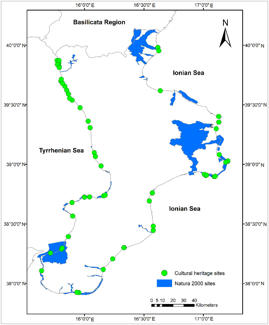
In this study, the SACs and the SPAs located along Calabria’s coastal zones and, in particular, the Natura 2000 sites, that fall within 300 m from the high water mark, in accordance with the “Galasso” Law (1479/89), have been identified. The selected coastal cultural sites, too, fall within an area of 300 m from the coastline (
Figure 2). Finally, the study has considered the only two islands situated along the regional seaboard: Cirella and Dino. This approach follows the ICZM Protocol guidelines, specifically Article 12, which grants “special protection to islands, including small islands”.
In the Calabria region, several policies have been adopted in the past to fight the effects of erosion. The Extract Plan of Coastal Erosion (PSEC) realized by the Calabrian Regional Basin Authority has provided the relevant information on this issue. The PSEC identifies three different hazard levels to characterize various degrees of coastline withdrawal in the Calabria region. These levels go from the lowest (P1) to the highest (P3). This classification is the product of coastal analysis carried out at multiple temporal levels. The realization of the PSEC has provided a general picture of the status of coastal erosion in Calabria, yet lacks any information about a global mitigation strategy to fight this phenomenon. Following the PSEC, the regional administration has developed a master plan of solutions to mitigate the risk of coastal erosion in Calabria (e.g., [
17]). This plan is based on a number of studies that have considered a hazard index, which includes several factors, such as the historical shoreline variations, wave climate, the type of the beaches and their slope, solid transport derived from hydrological basins, and the presence of coastal structures against erosion and harbor infrastructures. This tool has defined a scale of priorities in the planning and the intervention aimed at re-equilibrating the coastline for 21 macro-areas. In order to mitigate erosion in these areas, some interventions, such as nourishments, and coastal structures, like breakwaters and groins, have been proposed; yet, unfortunately, most of them have remained unrealized. However, no attention has been paid to finding sustainable solutions that integrate the risk of coastal erosion with the preservation of cultural and historical heritage sites diffused along the coasts of Calabria.
3. Materials and Methods
The present study performed a characterization to define a new type of landscape pattern, which, within the European regulations concerning the ICZM process, could incorporate the sustainable development of coastal zones by ensuring that the environment and landscapes are taken into account, in harmony with economic, social, and cultural development. To this aim, the chosen Natura 2000 and cultural heritage sites were grouped according to the following criteria: (1) cultural heritage sites located within Natura 2000 areas; (2) cultural heritage sites located within 200 m from the borders of Natura 2000 sites.
Moreover, the Coastal Erosion Hazard areas were included in this study in order to consider coastal vulnerability. A routine in an R statistical computing environment [
23] was developed to perform proximity and overlay analysis.
With the aim of detecting the coastal areas that are likely to be affected by erosion in the future, in this paper, two synthetic parameters representing irregular sea states were analyzed:
Hs and
Te.
Hs is the significant wave height, while
Te represents the period of a sinusoidal wave with the same energy of a sea state. This finds wide application in several studies linked to wave energy assessments for electrical purposes [
18,
24]. These two parameters are particularly important because they are directly linked to the wave power per unit of wavefront length,
P. For deep water conditions,
P is expressed as follows:
where
ρ is the water density and
g is the gravity acceleration.
The synthetic wave data were obtained from the ERA-Interim dataset by the European Centre for Medium-Range Weather Forecasts (ECMWF) but, following Caloiero et al. [
25], the wave data off the Calabrian coast were subject to a geographical transposition operation on the basis of effective fetches [
26] at the representative water depth of
h = 100 m. In fact, this position provided an ideal input for the analysis of wave propagation to nearshore areas. It also allowed for the investigation of the morphodynamic evolution of the beaches in the short-term, that is, at the temporal scale of sea storms when the cross-shore sediment transport was dominant [
27], and in the long-term, that is, at the temporal scale of several years, when the long-shore sediment transport was prevalent (e.g., [
28]).
The K-Means Cluster Analysis was applied to identify the coastal areas where the changes in the annual cycle of the variables were similar. The K-Means is a non-hierarchical clustering method, which starts by computing the centroids for each cluster, and then calculates the distances between the current data vector and each of the centroids, assigning the vector to the cluster whose centroid is closest to it. Since this is a dynamic method, meaning that vectors can change clusters after being assigned, this process is repeated until all vectors are assigned a cluster and their members are closer to the centroid than to the mean of other clusters [
29]. The mathematical condition for the cluster
Ck and the K-centroids
μk can be expressed as:
In order to evaluate the possible existence of temporal tendencies, the
Hs and
Te series were analyzed for trends, and their statistical significance was assessed with the MK nonparametric test [
30,
31], which has been widely used in sea states trend analyses [
32].
For a series with dimension
n, the MK statistic is obtained by the following:
where
xj and
xi are the data values at times
j and
i, with
j >
i.
If
xi are independent and randomly ordered, for
n > 10, the statistic
S follows a normal distribution with zero mean and variance given by the following:
with
ti being the number of ties of extent
i.
Finally, the standardized test statistic
ZMK is computed by the following:
Using a two-tailed test for a specified significance level α, the null hypothesis is rejected if |ZMK| is greater than Z1 − α/2, and the trend can be considered significant.
4. Results
There are 179 SACs and 6 SPAs in Calabria [
33]. For the purpose of the present study, among these, 55 SACs (30.7%) and 3 SPAs (50.0%) were chosen due to their complete or partial location on seaboard areas, and being within a range of 300 m from the coastline.
Of the 58 Natura 2000 sites, this study considered 313 habitats, which include marine (13%) and terrestrial (87%) ones.
Table 1 shows the first ten most representative habitats, corresponding to 55% of the Calabrian Natura 2000 sites.
By overlaying the Natura 2000 sites and the coastal erosion risk areas, the study evidenced that 50% of the surface area of 85% of the Natura 2000 sites are at high coastal erosion risk (P3). These include 63 cultural heritage sites: 8 castles (12.7%), 5 churches (8.0%), 37 coastal towers (58.7%), 11 archaeological sites (17.4%), and 2 Roman fisheries (3.2%). Among these, 76% of these cultural sites, scattered along the Calabrian coastline, and specifically, at a mean distance of 85 m from the coast, are at low erosion risk (P1). Instead, 3.2% of the sites, at a 3 m mean distance from the shoreline, are at medium erosion risk (P2), while 20.6% of the sites, located on average at 25 m from the coast, are at high erosion risk (P3). In regard to the geographical distribution of the sites, 42.9% of those located on the Tyrrhenian Sea are at low erosion risk, 1.6% are at medium erosion risk, and 11.1% are high erosion risk areas, and they are situated from the coast at average distances of 90.5 m, 3.0 m, and 12 m, respectively. By contrast, on the Ionian side, 33.3% of the cultural sites fall within a low erosion risk area, while 1.6% are at medium erosion risk and 9.5% at high erosion risk. The average distances of these sites from the coastline are 83 m, 4 m, and 35.5 m, respectively (
Table 2).
Furthermore, 49.2% of the cultural sites located along the Calabrian coasts fall within the 58 Natura 2000 core areas or within their buffer zones (200 m). By overlapping these with the coastal erosion risk areas, 35% of the sites, located at an average distance of 59 m from the coast, are classified as a P1 risk; 2% are at a P2 risk and at an average distance of 3 m from coastline; finally, 13% are situated within a P3 high risk area at an average distance of 12 m from the coastline.
In order to perform an in-depth analysis of the coastal areas affected by erosion, the mean annual
Hs and
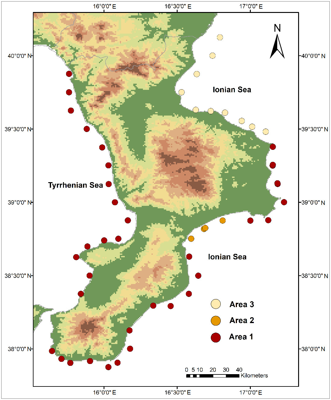
Te were studied. These two synthetic parameters of sea states were analyzed considering 50 points located at a water depth of 100 m, distributed along the coasts of the Calabria region, and obtained from the geographical transposition of the ERA-Interim dataset. First, by means of the K-Means Cluster Analysis, the coastal areas with similar changes in the annual cycle of the variables were identified. The results evidenced three main areas for both
Hs and
Te; the first area considered all the points on the Tyrrhenian side and several nodes in the central and the southern Ionian sides of the region; the second area included a few points on the central Ionian side of the region; the last area comprised the nodes on the northern Ionian side of the region (
Figure 3). Subsequently, a trend analysis of the mean series of
Hs and
Te evaluated in the three areas was performed. In particular, the series were examined for three different significance levels (SLs) equal to 90%, 95%, and 99%, respectively.
The results clearly evidenced an increasing trend of both the variables in the three areas, even with different significance levels. In fact, while
Te showed positive trend values ranging from 0.1 and 0.112 s/10 years with an SL of 99%, the
Hs values evidenced positive values between 0.008 and 0.14 m/10 years with an SL of 95% in Area 1, and an SL of 90% in Areas 2 and 3 (
Table 3).
Given the link between Hs and Te and the wave power per unit of wavefront length, the obtained increase in the mean Hs and Te values resulted in a higher percentage of higher and longer waves, and thus an increase in wave power. This effect can influence the beach morphodynamics with a consequent impact on short-term and long-term coastal erosion phenomena.
5. Discussions
Coasts represent transition areas between landward and seaward regions and open places of unstable balance where complex environmental dynamics interact. They also present coastal landscapes with a strong and rich cultural legacy. Nowadays, coastal and marine zones have become sensitive areas due to the considerable rise of anthropic levels and the pressure produced by a growing demographic trend. In Italy, rapid urbanization started after the so-called “economic boom” of the 1960s. This led to the uncontrolled expansion of coastal settlements, which today are exposed to increasing coastal hazards. In addition, the Italian coasts, often constellated by natural and cultural heritage sites, host important urban and industrial settlements, and constantly increasing tourist activities. Finally, a recent study showed that by 2100, the expected relative sea-level rise will change the present-day morphology dramatically, potentially flooding up to about 5500 km
2 of coastal plains at elevations close to present-day sea levels [
34].
Calabria shows a worrying decay of its seaboard areas, where 57% of the regional population lives [
35]. In particular, a soil loss of 28.4% in the regional coastal belt between 0 and 300 m from the coastline was recorded in 2015 [
36].
Cultural and natural heritage sites located along the Calabrian coastline are both subject to natural and anthropogenic hazards, which endanger their partial or complete survival. As a result, incorporating cultural sites within the Natura 2000 network could enable an effective process of Integrated Coastal Zone Management.
As these areas testify, coastal erosion constitutes the main hazard for both natural and cultural heritage. Following an ICZM-based approach would require long-term strategies to “facilitate, through the rational planning of activities, the sustainable development of coastal zones by ensuring that the environment and landscapes are taken into account in harmony with economic, social, and cultural development” [
37]. This requires innovative, integrated actions that offer a broader perspective on coastal management and are adaptable to the requirements of the different areas to sustain and use both cultural and natural goods with a high heritage value. Specifically, regional authorities ought to implement long-term plans to combat coastal erosion through the application of an efficient and effective coastal defense system. Prevention would thus help to avoid emergency actions. To this purpose, beach nourishment operations, combined with submerged breakwaters and/or groins, could be carried out in those coastal stretches damaged by erosion.
In order to successfully perform such recovery actions, a selection of suitable seafloor sands, collected near the continental shelf, and with a grain size greater than that of the native one must be selected to stabilize the beach [
38]. Coupled with coastal structures, beach nourishments constitute some of the key operations that regional policies advocate [
39]. Specifically, underwater archaeological goods could be better protected using semi-submerged mattresses made of geo-textile materials filled with sands. Indeed, such mattresses can be easily placed on, or removed from, the seabed and around archaeological remains [
40,
41,
42]. The transplantation of
Posidonia oceanica (Linnaeus) Delile shoots [
43,
44], as well as the use of its seedlings [
45], is a potential coastal restoration intervention that can be carried out in those coastal areas subject to higher human pressure, and in proximity of dead “matte” of
Posidonia oceanica meadows. Indeed, Posidonia beds represent a priority habitat, following the Habitat Directive (code 1120*). According to data analysis and a careful examination of the frequency distribution of marine habitats, Posidonia, or Neptune grass, is endemic to Calabrian coastal waters. In fact, Posidonia meadows constitute the typical marine ecosystem in the infra-littoral bottom of the Mediterranean Sea on mobile substrates, from the surface to a depth of approximately 35–40 m [
46], being the “climax” stage of a successional process [
47]. Specifically, this endemic species, forming large and widespread meadows in Mediterranean coastal waters, plays a fundamental ecological role with its high oxygenic and organic production. Furthermore, the meadows help to stabilize the coastal zone seabeds and actively help to limit the energy of sea states. At the same time, the store of
Posidonia oceanica leaves, through the formation of “banquettes” on the sandy beaches of the Calabrian coasts, is one of the most important natural defenses against wave action. Finally, the protection and restoration of coastal dunes represent a further defense system against coastal erosion. According to our results, the Calabrian coastal dunes are residual and very fragmented, and are present in 39.6% of the Natura 2000 sites. Protecting such sensitive habitats can occur through the implementation of nature-based solutions (e.g., fencing geo-textile nets and colloidal silica-based consolidation techniques) and by planting autochthonous vegetal species, such as
Erucastrum virgatum C. Presl and/or Calicotome infesta (C. Presl) Guss, which might yield significant protective results along the regional coastline.
ICZM is still largely seen as an environmental activity, and those institutions and actors responsible for the social and economic sustainability are yet to fully engage with it. The planning and management of the Natura 2000 and cultural heritage sites along the coast remain rigidly divided between policies, administrations, and institutions. More specifically, spatial planning for both sites is a major tool for ICZM and requires strengthening and better implementation [
37]. In order to enact the ICZM policies, the training of local and regional administrators involved in the environmental and cultural management of coastal areas should be promoted. Moreover, new business activities, including environmental and cultural tourism, and heritage-related tourist services, should be encouraged. Finally, the cultural growth of the local population and tourists, and their adoption of more sustainable lifestyles are essential to protect natural and cultural richness. The authors believe that targeted actions aimed at raising public awareness around the risk that natural and cultural heritage face could help prevent their deterioration. An awareness campaign would not only require the active participation of both the public authorities and the private sector; indeed, it should involve all the actors interested in the protection and development of coastal areas. In so doing, three different levels of public involvement in the ICZM policy could be identified. A thorough informational campaign would be aimed at the resident population and tourists who play a passive role. The safeguard of coastal dunes considered as “specific coastal ecosystems to preserve and, where possible, rehabilitate in a sustainable manner” by the partners contracting the ICZM Protocol, also requires the involvement of all the stakeholders, the local populations, and the tourists staying in the coastal areas, especially in the summer season. Then, in the areas that are more exposed to human impact, information systems, pathways, and walking routes could be implemented. Other actions include, where necessary, halting the movement and the parking of land vehicles, as well as the movement and the anchoring of marine vessels in fragile natural or cultural areas on land or at sea, including beaches and dunes [
48]. In sensitive marine areas, characterized by the presence of a
Posidonia oceanica meadow, an innovative system of boat anchoring with double and/or triple anchorages could be envisaged. Such a system might be modeled upon the one realized in the French marine protected area of Port Cros [
49] to reduce physical hazards, which is able to achieve a slow and gradual recovery of this endemic coastal ecosystem. All stakeholders should be fully involved in the decision-making process within effective landscape planning, and in the choice of priority actions for the development of productive activities and for the conservation of environmental and cultural legacy (intermediate role). Finally, the other actors involved in the ICZM process, such as, for instance, national, regional, and local authorities, must play a proactive role in the ICZM implementation.
6. Case Studies
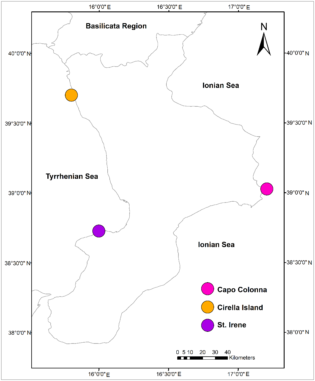
Three significant case studies (Capo Colonna, St. Irene, and Cirella Island) will now be illustrated to highlight the importance of an integrated approach to the preservation and management of both coastal zones and their cultural landmarks (
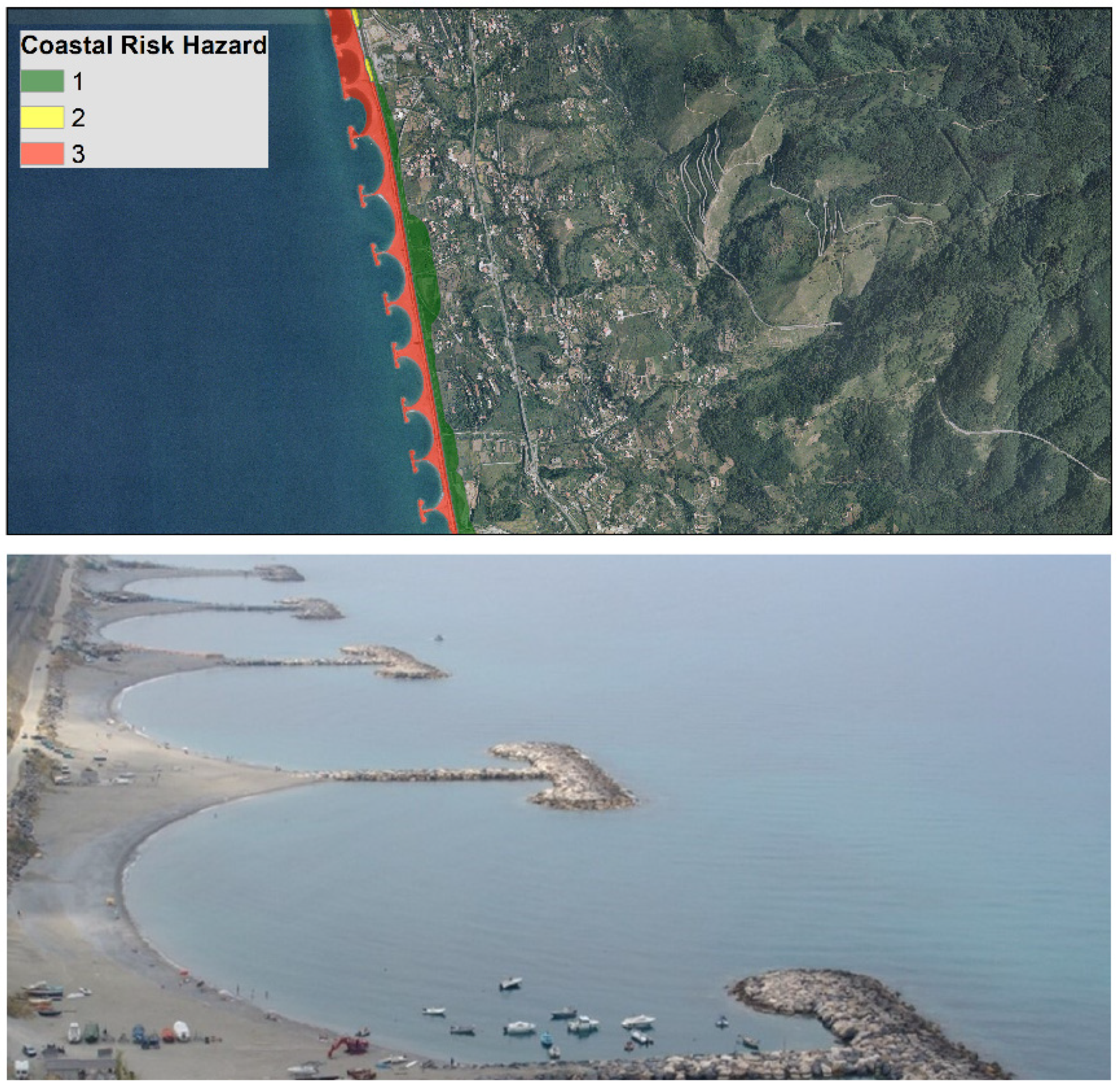
Figure 4). Indeed, 64% of the Calabrian coasts are at high erosion risk. For example, coastal withdrawal is prominent on the Tyrrhenian side, between Gizzeria (38°58′48″ N, 16°12′24″ E) and Belvedere Marittimo (39°38′11” N, 15°50′40″ E), and between Punta Alice (39°24′04″ N, 17°09′21″ E) and Capo Colonna (39°01’31” N, 17°12′08″ E) on the Ionian seaside.
The first area, on the Tyrrhenian side, is an extended coastal area where, in the last few decades, coastal engineering works have been realized, such as emerged breakwaters and groins, joined or detached from the coastline, oriented either cross-shore or long-shore, or in mixed directions (
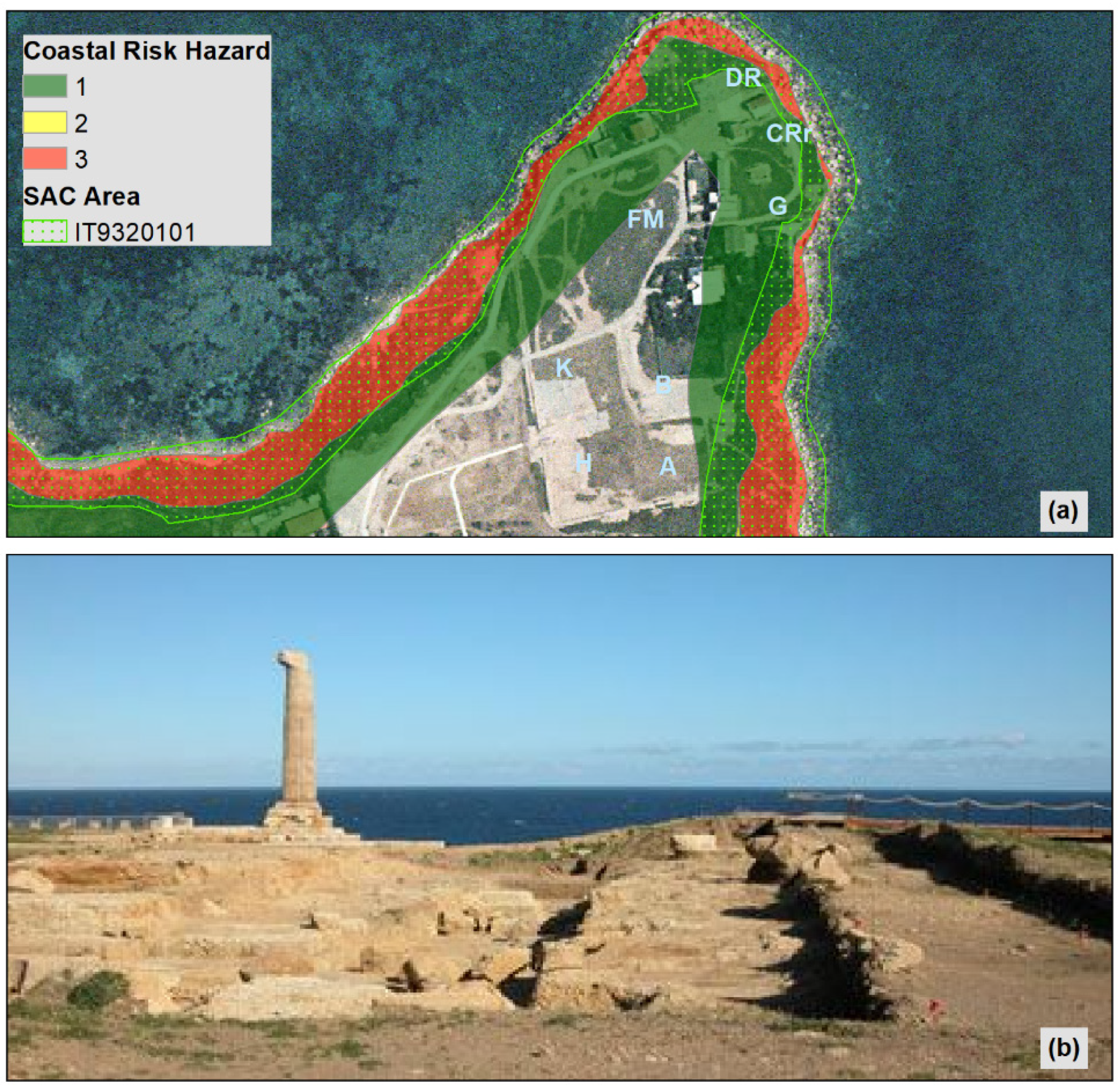
Figure 5). The latter area, on the Ionian side, has no coastal structures and is especially significant because the Marine Protected Area of Capo Rizzuto is here. This area is one of the 31 Italian protected areas, and has great environmental marine value. In addition, Capo Colonna, named after the only remaining Doric column of the ancient Greek temple of Hera (3rd century BC), testifies to the ancient Greek colonization of the region. Thus, in the same landscape pattern, both an important cultural heritage site and a Special Area of Conservation overlap.
This is a culturally significant zone for Calabrian heritage since, in this key archaeological area, extending for about 60 ha, Greek and Roman building remains can be found, dating back to the period between the 8th century BC and the 3rd century AC [
50] (
Figure 6). The archeological site, and especially those remaining buildings on the eastern side, are particularly close to the sea, about 7 m on average from the coast in a straight line. Already part of a house, or “domus”, has sunk into the sea. In regards to natural heritage, the promontory is a Special Area of Conservation (IT 9320101) due to its rich coastal habitat: Annual vegetation of drift lines (Habitat Code: 1210; see
Table 1); Vegetated sea cliffs of the Mediterranean coasts with endemic
Limonium spp. (1240); Salicornia and other annuals colonizing mud and sand (1310); Halo-nitrophilous scrubs (
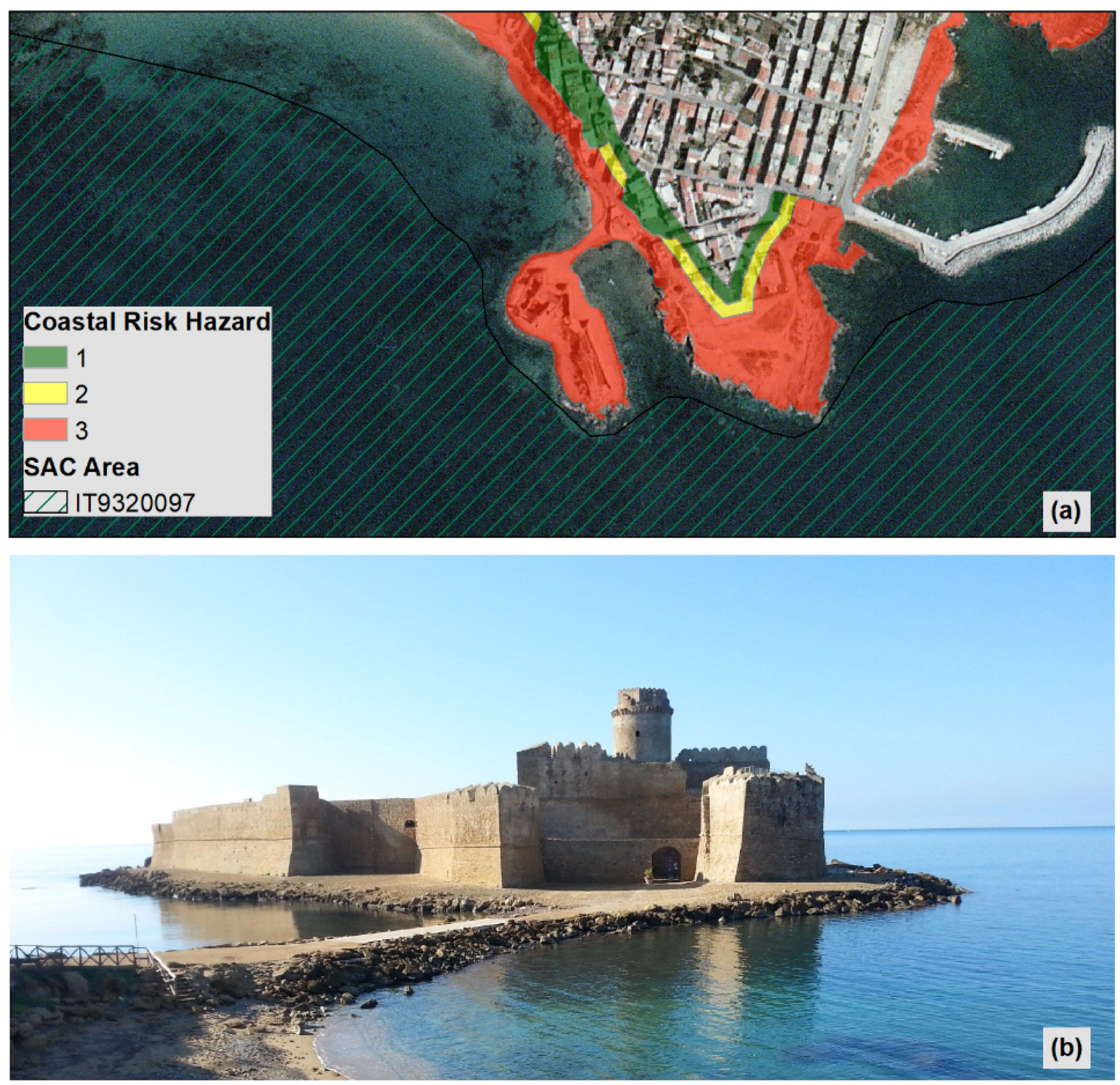
Pegano-Salsoletea) (1430). The main and highest risk factor is coastal erosion. In effect, the entire site falls within Area 1, where an increase in wave power has been detected. Moreover, different risk levels ranging from the lowest, P1, to the highest, P3, characterize this area. However, Capo Colonna is not the only site prone to coastal erosion. There are, in fact, several other sites subject to the same risk. One of these is Capo Rizzuto (38°54′25″ N, 17°01′16″ E), classified as a P3 risk level area. Again, in this case, a Natura 2000 site and a cultural heritage one overlap (
Figure 7).
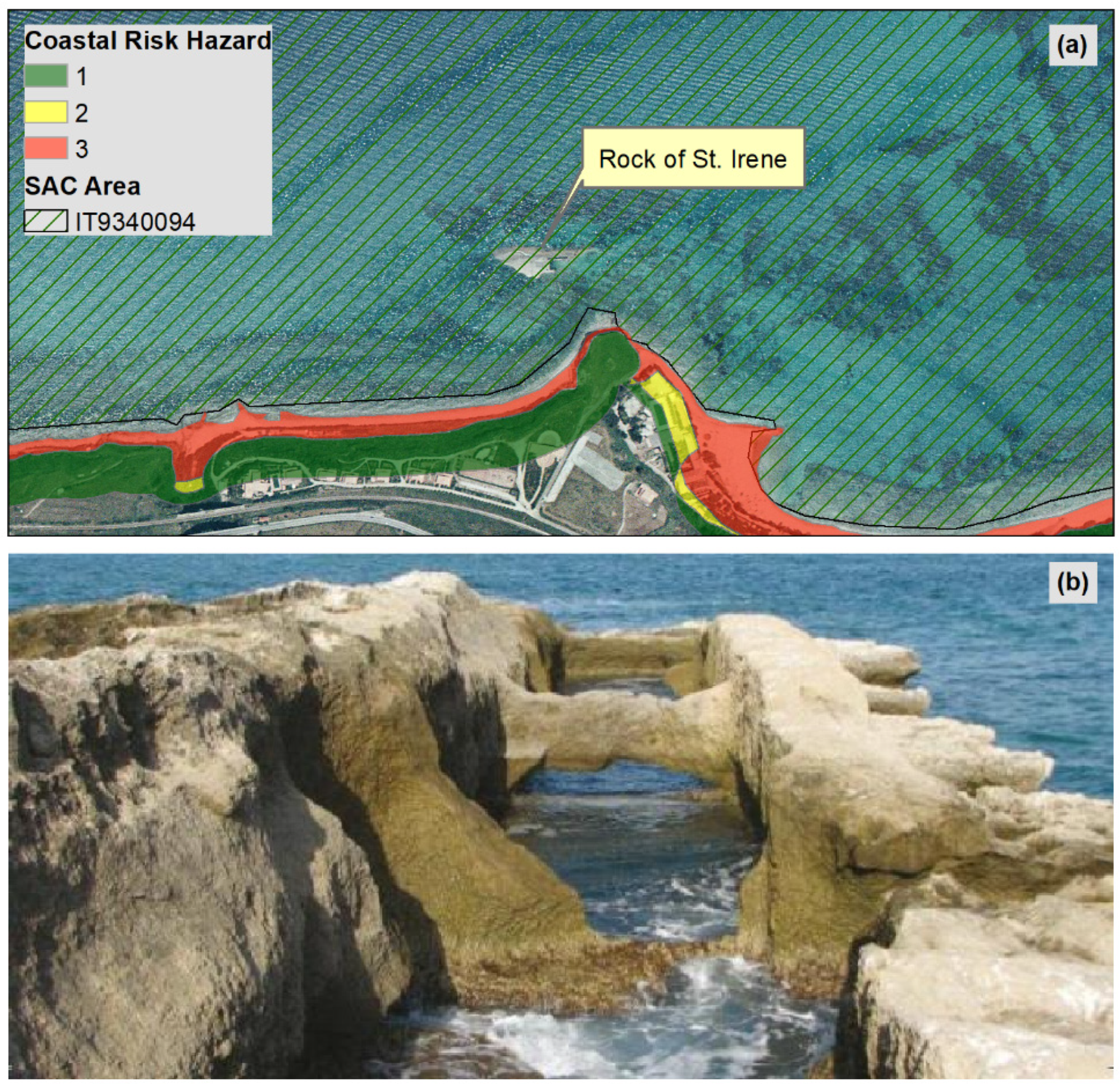
While coastal erosion remains the greatest risk, in several other coastal areas where Natura 2000 sites and cultural heritage overlap, human exploitation or the incorrect use of the coast constitutes a great risk factor. The rock of St. Irene, also known as Galea, is a case in point. Located at about one hundred meters from the Tyrrhenian coastline, it extends 120 m southwest in length and has a maximum width of 40 m (38°43′31″ N, 15°59′58″ E). It is a typical example of the ichthyic plant made by rock excavation (
Figure 8).
The fishpond, of medium dimensions, is composed of four pools showing the remains of flowing grooves and moving sluice gates, named “cataractae”. These were used to seal the channels and prevent the fish from escaping. Two channels connecting them with the open sea and an inner harbor perpendicularly cross the pools and allowed water exchange. In the harbor, salt fish were traded and “garum” produced. On the beach, opposite the plant, another complex of pools for fish salting, named “cetariae”, could be found [
51]. The area surrounding the rock of St. Irene, including the coastal stretch on its outskirts, is a Special Area of Conservation (IT 9340094) for the presence of the following habitats: Sandbanks which are slightly covered by seawater all the time (1110); Reefs (1170); and Posidonia beds (1120*, priority habitat).
The human impact on this site constitutes a high risk factor. As a matter of fact, the use of the coastal area for recreational activities exposes both the archaeological and natural goods to the risk of heavy damage to the cultural and the environmental legacy of this region. Other sites, such as Sant’Irene, are exposed to the same risk, resulting from incorrect human exploitation of the area. For instance, one could cite the case of the Stalettì rocks (38°45′40″ N, 16°34′17″ E), along the Ionian coastline. Here, a Special Area of Conservation has been established due to the presence of the following habitats: Annual vegetation of drift lines (1210); Vegetated sea cliffs of the Mediterranean coasts with endemic
Limonium spp. (1240); Thermo-Mediterranean and pre-desert scrub (5330); Pseudo-steppe with grasses and annuals of the Thero-Brachypodietea (6220*, priority habitat); Calcareous rocky slopes with chasmophytic vegetation (8210). Moreover, the presence of some cavities excavated in the rock has been recorded on the reef. These cavities could be traced back to some pools used for fish farming and for the “vivaria” of Cassiodoro [
50].
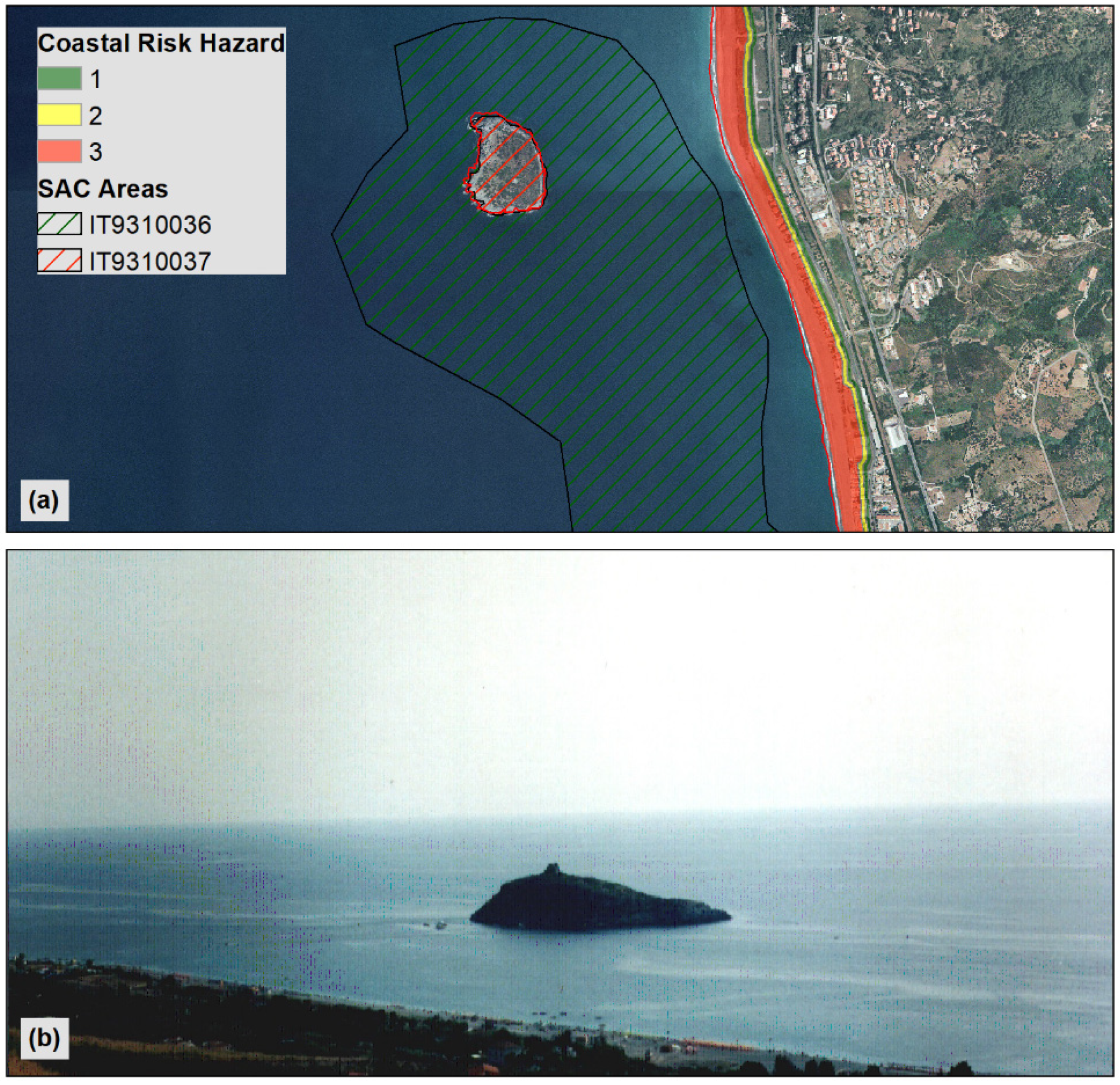
Finally, the isle of Cirella represents a further interesting case. The isle is situated along the Calabrian Tyrrhenian coast, at about 600 m from the shoreline (
Figure 9).
Due to its distinctive geographical position (39°69′88″ N, 15°80′16″ E), the evocative coastal tower, and its typical Mediterranean vegetation, the island is one of the most suggestive landmarks along the Calabrian coast. The whole island is a Special Area of Conservation because of the presence of many habitat types: Vegetated sea cliffs of the Mediterranean coasts with endemic
Limonium spp. (1240); Thermo-Mediterranean and pre-desert scrub (5330); Calcareous rocky slopes with chasmophytic vegetation (8210); Olea and Ceratonia forests (9320); and, at last, priority habitat 6220*, Pseudo-steppe with grasses and annuals of the Thero-Brachypodietea. Finally, a large meadow of
Posidonia oceanica is situated near the island, in its inland coastal waters. The meadow’s broad size allowed this marine site to become a Special Area of Conservation (Habitat 1120*, priority habitat) contiguous to the terrestrial one located at the top of the island. From a cultural point of view, a log-pyramidal tower on a square basis rises on the top of the island. Built in the 16th century as part of the coastal defense system against the Saracen invasions, the tower is now partially in ruin [
52]. Furthermore, some clay materials dating back to the 3rd century AC have been discovered in the marine areas between the islet and the coastline [
50]. In this important part of the Calabrian coast, human activity heavily impacts the area, constituting a high hazard for its coasts and habitats.
Great tourist demand in the summer period (June–September) risks endangering the Posidonia oceanica meadows because of the mechanical damage resulting from anchor grooving by boat mooring. At the same time, mass tourism affects the Saracen tower and the insular habitats, which lack any specific protection measures. Indeed, visitors are unaware of the cultural and natural richness of the area due to the absence of a local tourism board providing information. If made aware of the natural and cultural heritage of the area, tourists could enjoy the islet and protect it at the same time by adopting more sensitive behavior towards the site.
As in the case of the Cirella islet, on the Isle of Dino, natural and cultural heritage overlap as well. The whole island, located along the Tyrrhenian coast (39°50′18″ N, 15°46′22″ E), is a Special Area of Conservation (IT 9310034). It presents the following habitats: Vegetated sea cliffs of the Mediterranean coasts with endemic
Limonium spp. (1240); Thermo-Mediterranean and pre-desert scrub (5330); Pseudo-steppe with grasses and annuals of the Thero-Brachypodietea (6220*, priority habitat); Calcareous rocky slopes with chasmophytic vegetation (8210); Olea and Ceratonia forests (9320);
Quercus ilex Linnaeus and
Quercus rotundifolia Lamarck forests (9340). Finally, three different areas colonized by
Posidonia oceanica meadows can be found on the sea bottoms close to the island. Their presence led to making this marine site a Special Area of Conservation (IT 9310035). On the island, at its southern end, a tower by a log pyramidal section on a square basis is located. This tower was built in the 16th century AC, and it was characterized by five dropouts and a typical drawbridge connecting the outside staircase with the feasible floor [
52].


 ,
, 


