Article

Geosites and Geotourism in the Local Development of Communities of the Andes Mountains. A Case Study

by
Paúl Carrión-Mero
1,2,*,
César Borja-Bernal
3,*,
Gricelda Herrera-Franco
4,
Fernando Morante-Carballo
1,5,6,
María Jaya-Montalvo
7,
Alfonso Maldonado-Zamora
8,
Nataly Paz-Salas
7 and
Edgar Berrezueta
9
1
Centro de Investigación y Proyectos Aplicados a las Ciencias de la Tierra (CIPAT), ESPOL Polytechnic University, Guayaquil 9015863, Ecuador
2
Facultad de Ingeniería en Ciencias de la Tierra, ESPOL Polytechnic University, Guayaquil 9015863, Ecuador
3
Facultad de Ciencias Naturales, Universidad de Guayaquil (UG), Guayaquil 9015863, Ecuador
4
Facultad de Ciencias de la Ingeniería, Universidad Estatal Península de Santa Elena (UPSE), La Libertad 240204, Ecuador
5
Facultad de Ciencias Naturales y Matemáticas (FCNM), ESPOL Polytechnic University, Guayaquil 9015863, Ecuador
6
Geo-Recursos y Aplicaciones GIGA, ESPOL Polytechnic University, Guayaquil 9015863, Ecuador
7
Bira Bienes Raíces S.A. (BIRA S.A.), Zaruma 071350, Ecuador
8
Departamento de Ingeniería Geológica y Minera, Universidad Politécnica de Madrid, Escuela Técnica Superior de Ingenieros de Minas y Energía, 28031 Madrid, Spain
9
Departamento de Infraestructura Geocientífica y Servicios, Instituto Geológico y Minero de España (IGME), 33005 Oviedo, Spain
*
Authors to whom correspondence should be addressed.
Sustainability 2021, 13(9), 4624; https://0-doi-org.brum.beds.ac.uk/10.3390/su13094624
Submission received: 25 March 2021 / Revised: 13 April 2021 / Accepted: 14 April 2021 / Published: 21 April 2021

Abstract

:
The inventory and assessment of a geosite in a territory provides a sound basis for the protection and use of its geological heritage. This article aims to evaluate the most relevant geosites in the province of Chimborazo (Ecuador), applying the Spanish Inventory of Sites of Geological Interest (IELIG, in Spanish) method, and proposing alternatives for geotourism development in the studied area. The methodological process was based on: (i) the inventory and preliminary selection of geosites; (ii) a semi-quantitative geosite assessment and proposal of travel itineraries for geotourism; and (iii) the application of the strengths, weaknesses, opportunities, and threats (SWOT) matrix to establish geotourism development strategies within a framework of sustainability. The global assessment of scientific, tourist, and academic interests demonstrates that 25% of the 20 evaluated geosites have very high interest and 75% have high interest. The top three geosites with the highest degrees of interest are the Chimborazo Volcano, known as ‘Earth’s Closest Point to the Sun’, the Pallatanga geological fault, and the geosite named Comunidad Cacha. The SWOT analysis reveals that travel itineraries that combine cultural heritage elements and geosites could offer a real alternative for the region’s sustainable development through geotourism.

1. Introduction

The term geodiversity was first introduced in the early nineties. According to Gray [1], geodiversity is the variability of Earth’s surface materials, landforms, and physical processes (abiotic elements). Materials are the rocks, soil, or the water; mountains, glaciers, and lakes are examples of landforms; and soil formation, coastal erosion, and sediment transport could be mentioned as processes. A definition of geodiversity, at a local scale, was suggested as a synthesis of the landscape that includes geological, hydrogeological, geomorphological, and climatic elements and processes [2]. The Law of Natural Heritage and Biodiversity (BOE Law 42/2007) of Spain [3], defines it as “The variety of geological elements, including rocks, minerals, fossils, soils, landforms, formations and geological units and landscapes that are the product and record of the evolution of the Earth”. Geodiversity must be regarded as part of the natural heritage of the territory, which shapes the evolution of the planet and favors the development of life [4,5,6].
When the constituent elements of geodiversity have a high scientific value, they are known as geological heritage or geoheritage [7,8]. Geoheritage is inherent to natural heritage. It includes forms, elements, and structures originated by geological process and has a crucial role in understanding Earth’s history [8,9].
Social perception of geodiversity and geological heritage has changed over time. Today, it is considered a right, a need, and a duty to protect the environment through the safeguard of geosites [10]. A geosite is a site where one or more geographically well-defined elements of the geodiversity are present and it has a singular tourist, cultural, or scientific value [2]. According to Prosser [10], geosites are sites with a high scientific value, assessed quantitatively and qualitatively through an inventory, assessment, and selection process to develop a management and threat prevention plan. Movable geological heritage also exists; it refers to vulnerable elements of earth sciences exposed to natural degradation or human action that can—or must—be protected ex situ. Their inclusion into a museum collection often means the only chance for the preservation of these invaluable inanimate natural monuments [11,12]. Geosites are sites with geological and geomorphological interest that are part of geological heritage and promote its conservation. It is important to note that, in recent years, there has been an increase in the number of UNESCO geoparks, reaching 161 in 2020 [13]. This circumstance has initiated many geosite characterization studies and the development of assessment methods [9]. According to [14], the basic study and the securing of geosites must follow a careful study that leads to their evaluation, while respecting their original features, in order to inform the development of sustainable tourism.
For the characterization of geosites—inventory, diagnosis, promotion, and management projects of geological resources have been carried out in several countries [15,16,17,18]. The Spanish Inventory of Places of Geological Interest (IELIG, acronym in Spanish) [19], as referenced by Serrano and González [20], Brilha [2], and Medina [5], is one of the methods widely used in geosite characterization [21,22,23,24,25]. The existing procedures are improving and evolving to provide a global evaluation of the geological heritage, considering tourist, scientific, and academic criteria. The geological routes (georoutes) are itineraries that aim to the geological heritage’s value through the connection of different geosites. Examples of these georoutes can be found in Spain, such as the “la pizarrilla” geotrails, in Jaén [26]; the geotrails in the Yanhuitlán Geopark, in the Mixteca Alta-Oaxaca (Mexico) [27], and the geological itinerary of Sasso di Castalda in Italy [28].
Characterization procedures are based on the quantification of visual and susceptible aspects and the use of statistical data analysis to evaluate geological characteristics of geosites [17]. The IELIG method is the base methodology recommended by the ASGMI (Ibero–American Association of Geological and Mining Surveys) for assessing sites of geological interest in Ibero-America [29]. In Ecuador, it is the most commonly used assessment method (e.g., [30,31,32,33,34]). In general terms, the IELIG method [19] builds upon the work of experts who define the instrumental values of geosites (scientific, educational, and recreational tourism potential), together with susceptibility to degradation and protection priorities.
Geotourism has been conceptualized as the union of three components: forms, processes, and tourism [35,36]. Forms include existing landscapes with their characteristics and components. Processes include tectonic activity, weathering, deposition, etc. Tourism refers to the human dimension reflected in tourist activities and the appreciation of geology and geomorphology, among others [37,38]. The United Nations Educational, Scientific and Cultural Organization (UNESCO) mentions that geotourism implies traveling through a territory where the tourists explicitly understand that the landscape they observe contains unique forms modeled by dynamic processes that have left visible traces [39,40].
Geotourism cannot be reduced to ‘geological tourism’, but rather it is a broader concept, where the focus of attention is the geosite, the geological phenomena, the tourist use of the landscape potential, and the culture and customs of the local population [41,42]. It is essential to remember that the geotourism sector dynamics are prone to be influenced by impacts and crises deriving from environmental, climatic, and social factors [7,43,44,45,46].
The target region of this study is the province of Chimborazo (Ecuador). This province has remarkable cultural, natural, intangible, and geological characteristics with the potential to be officially recognized as elements of natural or cultural heritage [47,48]. The main economic activities in the area are agriculture, livestock breeding, mining, and handicrafts [49,50]. Tourist activity is also noteworthy, although, despite the singularities of the natural features and the efforts of regional and local authorities, geotourism does not reach its full potential [51,52]. The main reason for this could be the absence of a strategic plan that should include the inventory, characterization, and promotion of the territory’s geological characteristics. One of the objectives of this study is to assess whether the socio-economic development of the territory could be stimulated by the inclusion of geosites in the tourist offer to complement traditional tourism.
The aim of this work is to evaluate the most notable geosites in the province of Chimborazo (Ecuador) by applying the semi-quantitative method of the IELIG and an analysis of strengths, weaknesses, opportunities, and threats (SWOT). We also wished to propose itineraries for the development of geotourism in the region. To reach our goals, we compiled and analyzed available information, and then employed international methods for the assessment of geosites located in the study area. This work is meant to lay the foundation for more detailed future works.

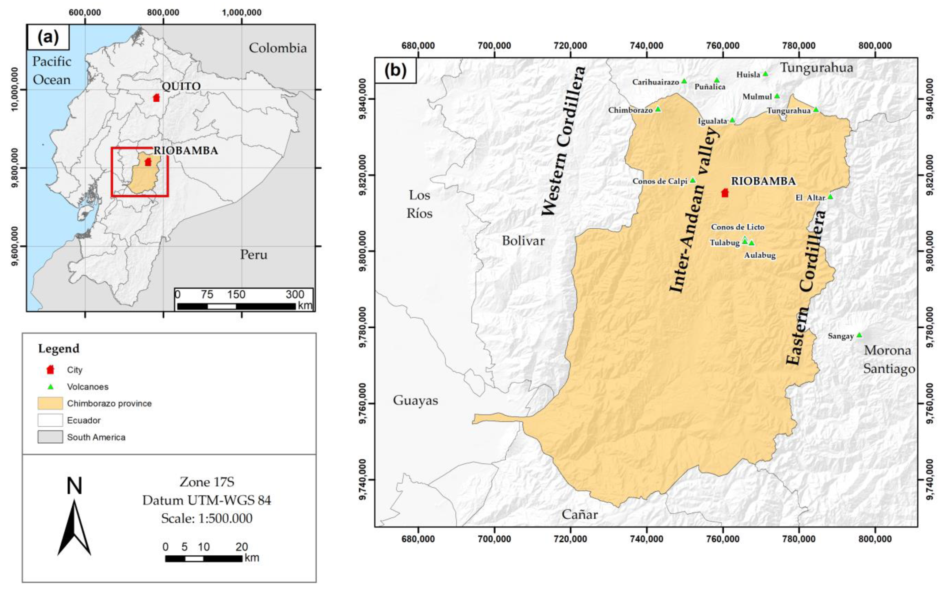
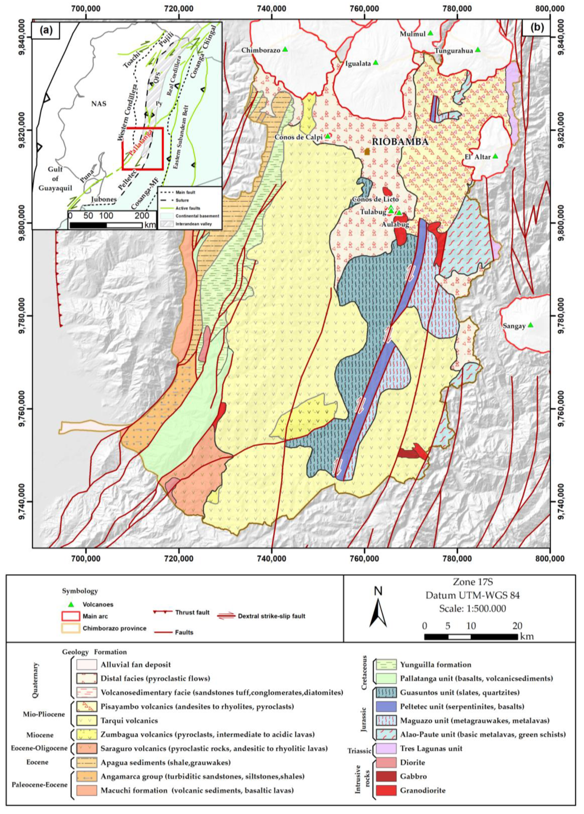
2. Geographical and Geological Setting

2.1. Geographical Setting

The Chimborazo province is in the south-central part of Ecuador, in the Inter-Andean region or Sierra (Figure 1). Its capital, Riobamba, is located 210 km southwest of the city of Quito (Ecuador). Its extension is of 6499.72 km2, and it has a population of 458,581 inhabitants, 59.20% of which reside in rural areas [53]. From north to south, the province is crossed by the Western and Eastern Cordilleras and the Inter-Andean valley (a tectonic depression) between them [54]. The area is in the extreme southwest of the main volcanic arc of Ecuador [55], where the Chimborazo volcano rises. This is the highest volcano in the Northern Volcanic Zone of the Andes (6263 m above sea level) [56,57], and it is known as the farthest point from the center of the earth (6384 km), two kilometers farther than the Everest with its 6382 km [58,59]. There are also other volcanic centers that belong to the volcanic domain of the Inter-Andean valley, although most of them are extinct (e.g., centers of Igualata, Llimpi-Huisla) [60].

2.2. Geological Setting

Regionally, Ecuador is divided into tectonostratigraphic zones that extend parallel to the Northern Andes mountain range. From west to east, these are: (1) the oceanic terranes of the coastal region and the Late-Cretaceous Western Cordillera [61,62,63,64]. (2) the Chingual-Cosanga-Pallatanga-Puná (CCPP) dynamic fault system [65], which is also the eastern tectonic limit of the “North Andean Sliver” and is related to the oblique subduction of the Nazca plate. It formed a 20 to 30 km wide and 300 km long structural depression [60] known as the Inter-Andean valley, includes a dozen older andesitic volcanic centers [65], and deposits from the Miocene to the Holocene [60,63,66]. Finally, (3) the Eastern or Real Cordillera, separated from the Inter-Andean Valley by the Peltetec Fault, which is the continuation of the Romeral Fault of Colombia. This fault lies on a sequence of basal rocks from the Paleozoic to the Cretaceous of the South American Plate [67].
The study area (Figure 2a,b) comprises the southern termination of the Ecuadorian arc, where it is possible to identify volcanic centers from the late Pliocene to the Quaternary, including three of the four types of volcanism [60]. The volcanic front of the Western Cordillera includes andesitic to dacitic composite stratovolcanoes, such as the El Chimborazo volcano [68]. The volcanic center of the Eastern Cordillera is mainly composed of andesitic stratovolcanoes, such as El Altar, a volcano that has not been studied in detail so far [66]. Moreover, the andesitic volcanic centers of the Inter-Andean valley, such as the Calpi and Licto slag cones, located in the Riobamba basin, are the result of the lower inclination of the subduction zone caused by the subduction of the Carnegie Ridge [60], and their period of activity is unknown [66].
From the lithological point of view, in the Chimborazo province, geological units of sedimentary, igneous, and metamorphic rocks emerge, ranging from the Triassic to alluvial deposits of the Quaternary (Figure 2b). These geological formations are affected by the sector’s structural dynamics associated with the locally known Pallatanga Fault (Figure 2a), a NNE–SSW strike-slip fault that crosses the central part of the study area. This fault is believed to have caused the 1797 Riobamba earthquake [69].
The oldest lithologies are exposed along the western margin of the Eastern Cordillera, which marks the eastern border of the province (Figure 2a,b). They are composed of S-type granitoids of the Tres Lagunas unit [71], followed by Jurassic rocks, such as the metalavas and green schists of the Alao-Paute unit, metagrauvacas, and metavolcanites of the Maguazo unit. The Peltetec ophiolite and the Guasuntos Jurassic Unit are also discontinuously exposed, separated by the Peltetec Fault [71,72]. The Peltetec ophiolite was interpreted as an oceanic lithospheric section generated in a suprasubduction environment [71].
The Cretaceous units are in the western part of the area, composed of basalts and volcano-sediments of the oceanic plateau grouped in the Pallatanga unit and quartz-bearing turbidites of the Yunguilla formation [73]. The Paleocene–Eocene geology is represented by the andesites and volcanoclasts of the Macuchi formation and the Angamarca Group, which includes black and grey turbidites of the Apagua Formation of the late Eocene. In the south of the province, pyroclastic rocks and andesitic to rhyolitic lavas of the Saraguro outcrop are located. Moreover, in the central part, Miocene volcanoclastic deposits of the Zumbagua, and Mio-Pliocene pyroclastic deposits of the Tarqui and Pisayambo volcanics can be found. Other features are areas covered by glacial deposits, reworked pyroclasts (cangahua, distal facies (Figure 2b)), primary hot gas-rich pyroclastic flows (tephra, pyroclastic flows, ignimbrites), lahars and avalanches of the Quaternary [57,70], and intrusive rock outcrops.

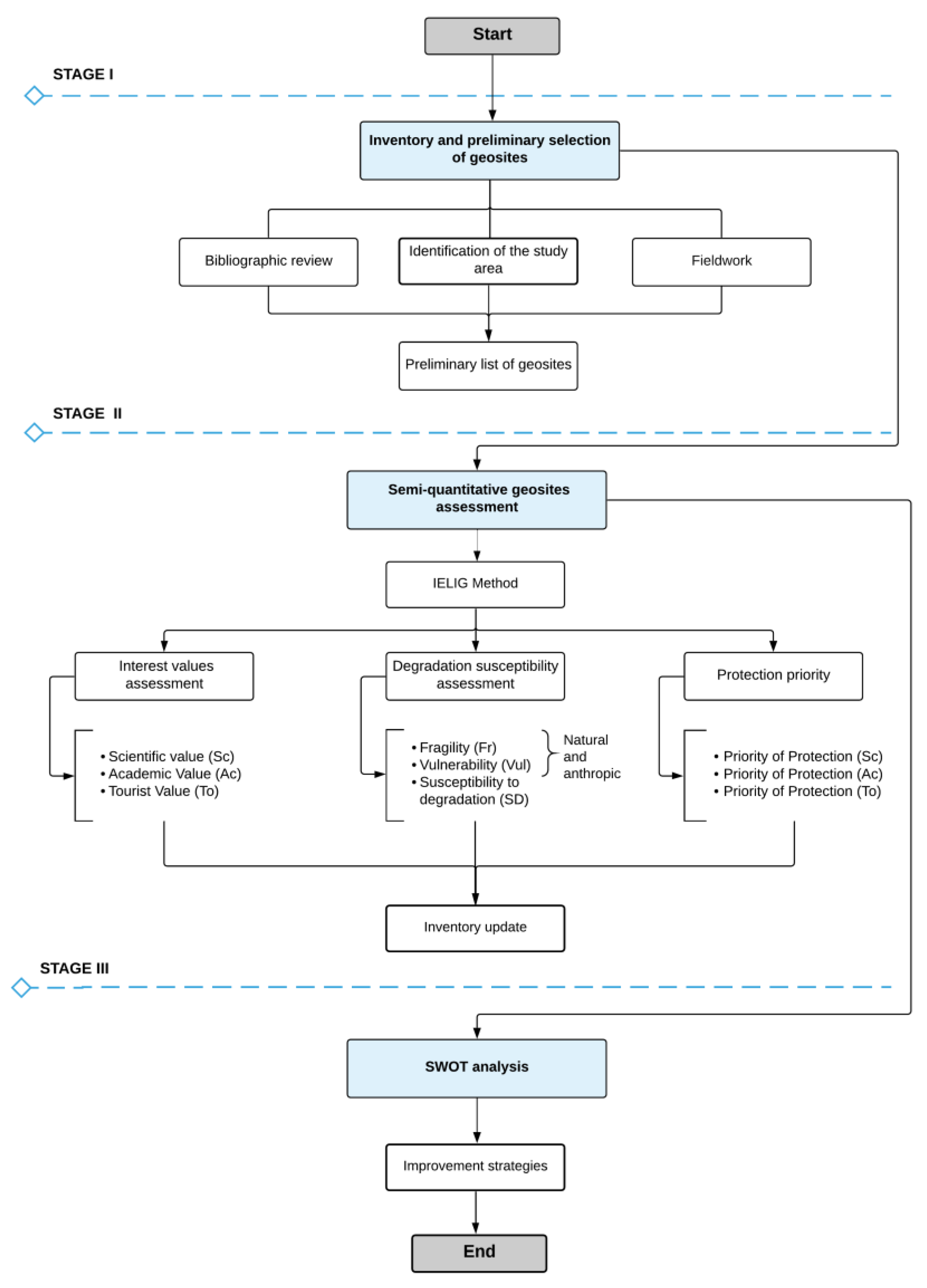
3. Materials and Methods

In this article, the IELIG method was applied to identify and select sites of geological interest (SGI) or geosites. Additionally, we used a SWOT analysis to evaluate the relationship between the geosites and the community. The proposed evaluation process was based on the guidelines, classification and assessment of a previous study by García-Cortés [19]. The IELIG does not only identify geosite targets of the inventory and their geological environment, but it also provides a diagnosis to design geoconservation measures. The study was structured into three stages (Figure 3): (i) phase I consisted of compilation of information, inventory, and preliminary selection of potential geosites; (ii) in phase II, the IELIG method was applied for the assessment of the selected geosites; and finally, (iii) phase III involved the strengths, weaknesses, opportunities, and threats (SWOT) analysis of the geosites regarding their contribution to the geotourism development of the region.

3.1. Inventory and Preliminary Selection of Geosites

In the first phase, we compiled information about the geosites from various sources, such as scientific articles, theses, thematic cartography, and other studies developed in the area. We also reviewed and correlated some points of the project framework ‘Registry of geological and mining heritage and its impact on the defense and preservation of geodiversity in Ecuador’ [74]. The aim of this phase was to obtain an overview of the geographical, social, and geological characteristics of the territory for the preliminary selection of potential geosites.

3.2. Semi-Quantitative Geosite Assessment

The IELIG method [19] was applied for the semi-quantitative assessment of the list of sites obtained in the preliminary phase (3.1). This procedure, unlike others, considers protection priority (Pp), which is an essential indicator of priorities in conservation actions. Table 1 shows the parameters and weights established by the IELIG to assess the scientific (Sc.), academic (Ac.) and touristic (To.) value of each site. A score of 0 to 4 is assigned to each parameter by experts.
According to the values obtained for each geosite (i.e., scientific, academic, and tourist interest) considered in the study area (Table 1), the aim is to analyze to what extent their protection is a priority. Equation (1) is used to calculate the degradation susceptibility (DS), based on parameters, such as fragility and vulnerability due to anthropic threats, and assigned weights [19], shown in Table 2.
DS = Fr . × Vul . 400 ,
From the degradation susceptibility (DS), Equations (2)–(4) were used to obtain the values of protection priority (Pp) in its different domains: scientific Pp (Sc.), academic Pp (Ac.), and tourist or recreational Pp (To.). The global protection priority Pp (Equation (5)) generates a comprehensive value about the state of the geosite; it can be used to update the inventory of geosites, and to focus on those places that need restoration or application of appropriate conservation measures. The different sub-parameters to assign each type of value (0 to 4) are shown in detail in a study about the Spanish Inventory of Places of Geological Interest (IELIG) in its 2013 version [19].
Pp   ( Sc . ) = ( ISc . ) 2 ×   DS   × ( 1 / 400 2 ) ,
Pp   ( Ac . ) = ( IAc . ) 2 ×   DS   × ( 1 / 400 2 ) ,
Pp   ( To . ) = ( ITo . ) 2 ×   DS   × ( 1 / 400 2 ) ,
Pp   = (   ISc . +   IAc . +   ITo . 3   ) 2 ×   DS   × ( 1 / 400 2 ) ,

3.3. SWOT Analysis

In phase III, we analyzed the strengths, weaknesses, opportunities, and threats (SWOT) [75] of the assessed geosites. The analysis was developed with the participation of members of the academy and researchers. The aim of the SWOT analysis was to determine the area’s potential in a more ambitious future project and to propose initiatives for the efficient and effective use of the geosites and their environment. Finally, as a product of this third phase, specific alternatives for optimizing geotourism were defined. The interpretation of the analysis described in previous sections provided the basis for these alternatives.

4. Results

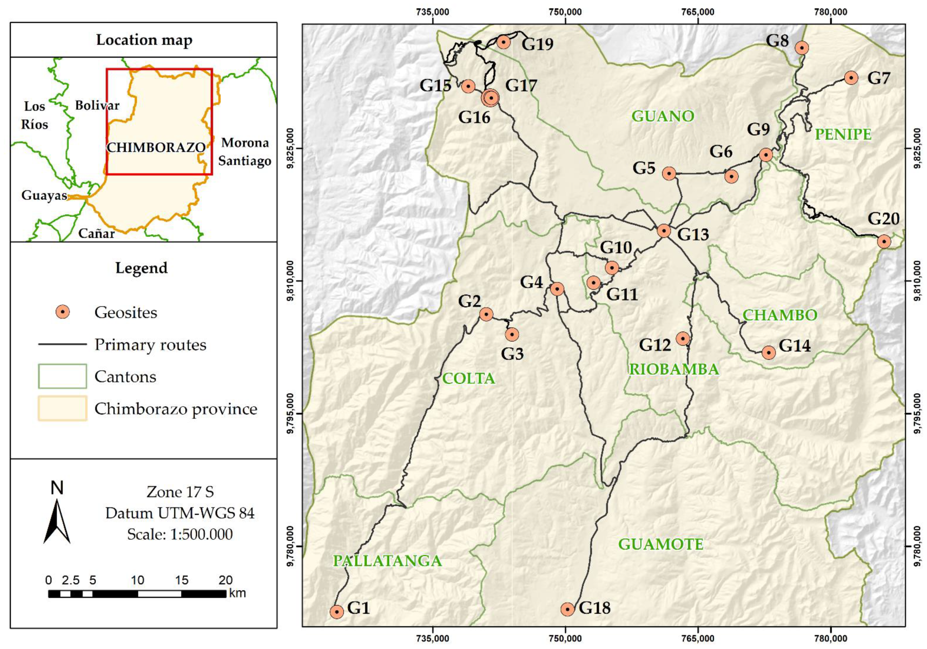
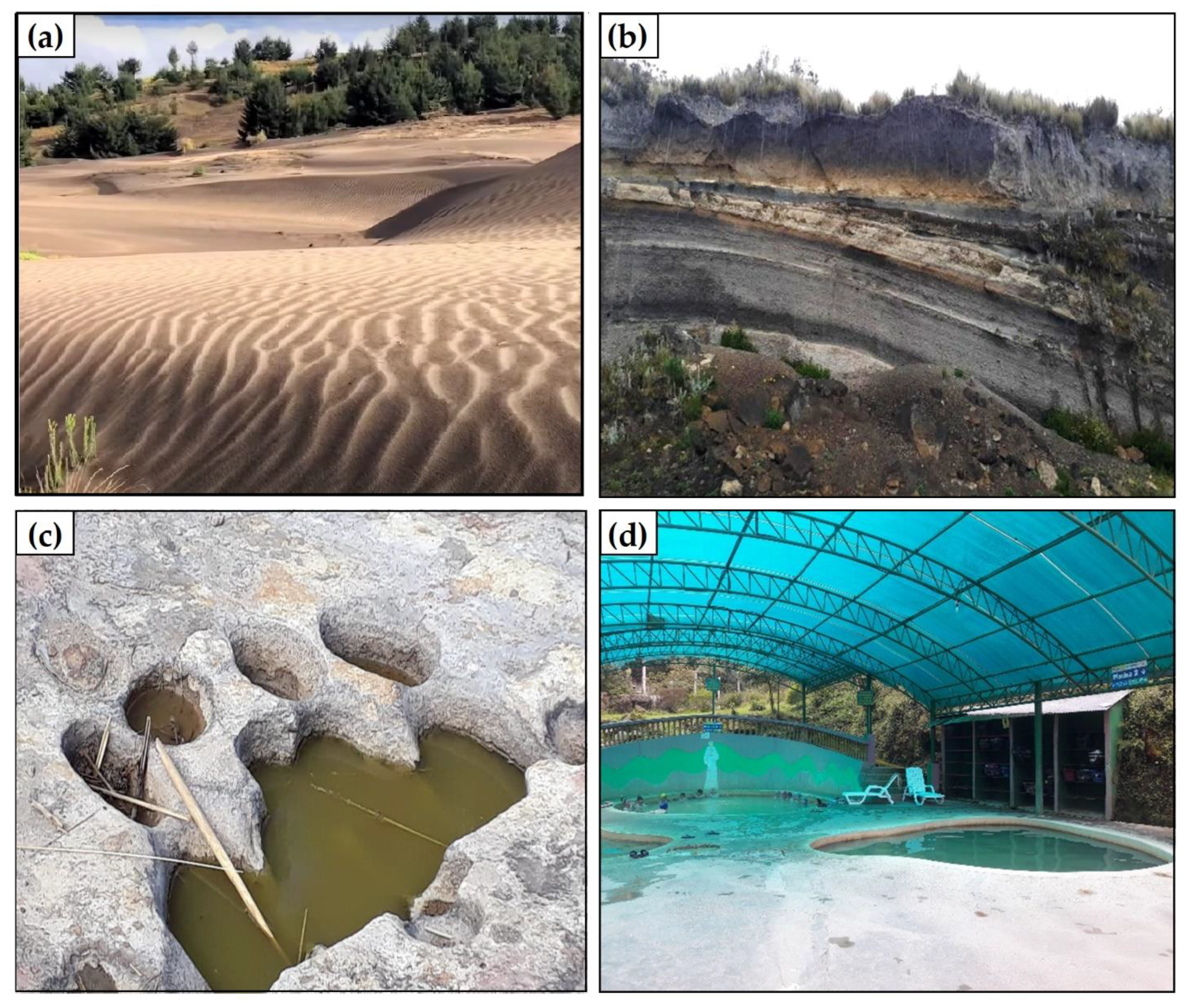
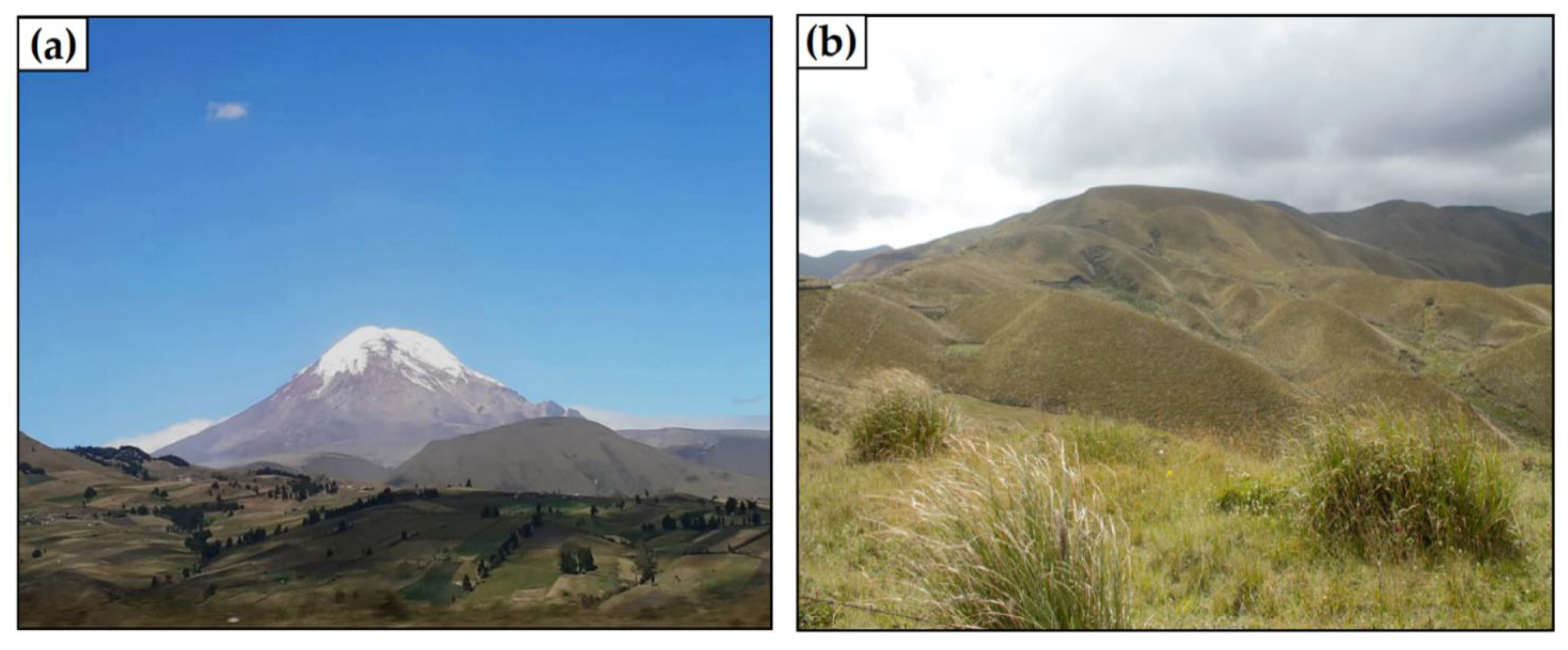
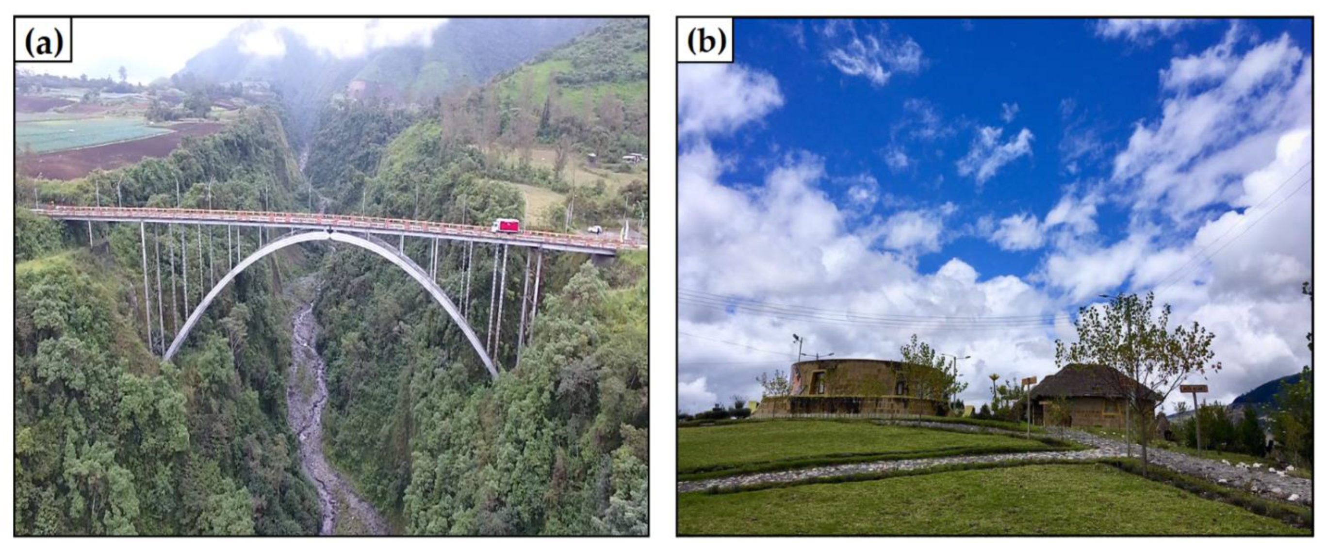
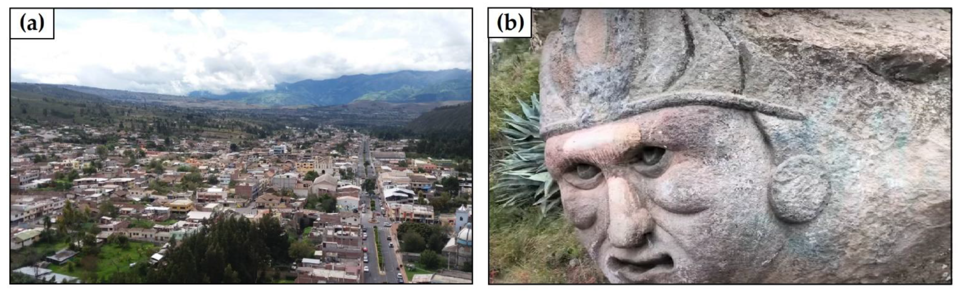
4.1. Geosite Inventory and Description

Based on the collected information, 20 geosites were selected for detailed analyses. The selected sites have unique geological features determined by a specific geological description. In Figure 4 and Table 3, the selected sites and their primary geological interest type are shown. Figure 5 highlights the outstanding geological features of four of the identified geosites.

4.2. Geosite Assessment

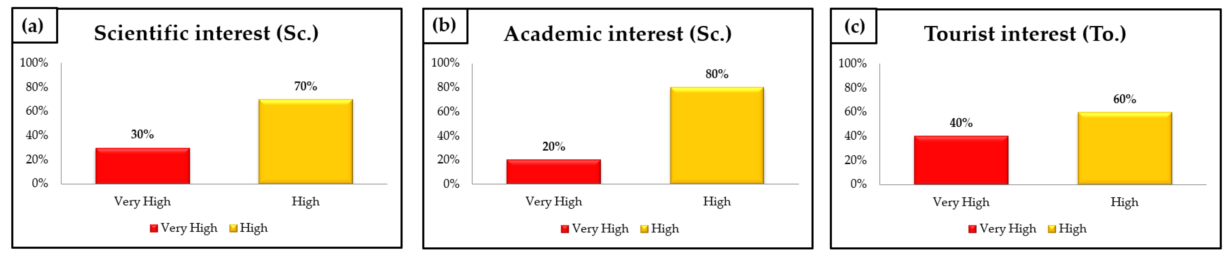
4.2.1. Assessment of Scientific, Academic, and Tourist Interest

Table 4 presents the global results obtained from the average values of Sc., Ac., and To. interest types (Av = (Sc. + Ac. + To.)/3) regarding the 20 sites assessed by the IELIG method. The Chimborazo volcano has the highest and the Pozo Chingazo site the lowest average interest value (373.33/400 and 180.00/400, respectively, Table 4). In summary, 25% of the geosites have very high interest and 75% high interest.
Six geosites, 30% of the total, reached the ‘very high’ range of scientific interest (Sc.). The Chimborazo Volcano (Figure 6a), known as the farthest point from the center of the earth (6384 km) [58,59], or ‘Earth’s Closest Point to the Sun’ [76], reached the highest score, 380. This significance of this geosite is increased by the facts that it is the highest mountain in Ecuador and hosts a large wildlife reserve [57,77]. Of the fourteen remaining geosites (70% of the total), the Páramo Guacona (Figure 6b) must be mentioned in the ‘high’ range (Figure 6b) with 265 points. Its importance is due to the springs that emanate in this moorland. It is located between the Llin and Navag moors. Currently, water harvesting, and channeling projects are being designed in the area. From the geosite, it is possible to appreciate the ‘V’ shape of the hydrographic systems, indicative of active in-depth erosion and significant vertical uplifts.
Regarding academic interest (Ac), four geosites (20%) have a ‘very high’ interest: the Chimborazo Volcano (370), the Páramo Guacoma (310), the Falla Pallatanga (Figure 7a), and the Cacha Community (Figure 7b) (with 305 points both). The Pallatanga Fault is a regional strike-slip fault that caused the 1797 Riobamba earthquake [69]. It provoked an approximately 956 kilometer long [78] longitudinal breach cutting through five provinces of Ecuador. The Cacha Community comprises rustic huts and circular museums as part of the Pucaratambo tourist center [79]. This geosite has added value due to its tremendous cultural potential, as it is the cradle of the influential Puruhá people. The remaining sixteen sites (80%) reached the ‘high’ range of interest, which proves that most geosites have great relevance in this area. The Laguna de Colta geosite reached the highest score, 260 points, in this category (Figure S1).
The tourist interest (To.) assessment revealed that eight sites (40% of the total) are within the ‘very high’ range, again with the Chimborazo Volcano (Figure 6b) in the first position (370 points). The remaining twelve sites (60% of the 20 selected sites) are within the ‘high’ range. The highest score in this category was obtained by the Mirador de Guano geosite and the Riobamba Megaterios Footprints (see Figure 5c) (260 points, both). The Mirador de Guano is situated on a rock formation of volcanic origin named Colina Lluishig. From this viewpoint, it is possible to observe the Chimborazo volcano, El Altar volcano, Tungurahua Volcano, and Guano city (Figure 8a). On the way up to the viewpoint, there are monoliths carved in the middle of the 20th century. The most outstanding ones are the fish, the vessel, and the face of the Inca (Figure 8b).
The global assessments of the scientific, tourist, and academic interests are reflected in Figure 9, merging the results of the 20 geosites.

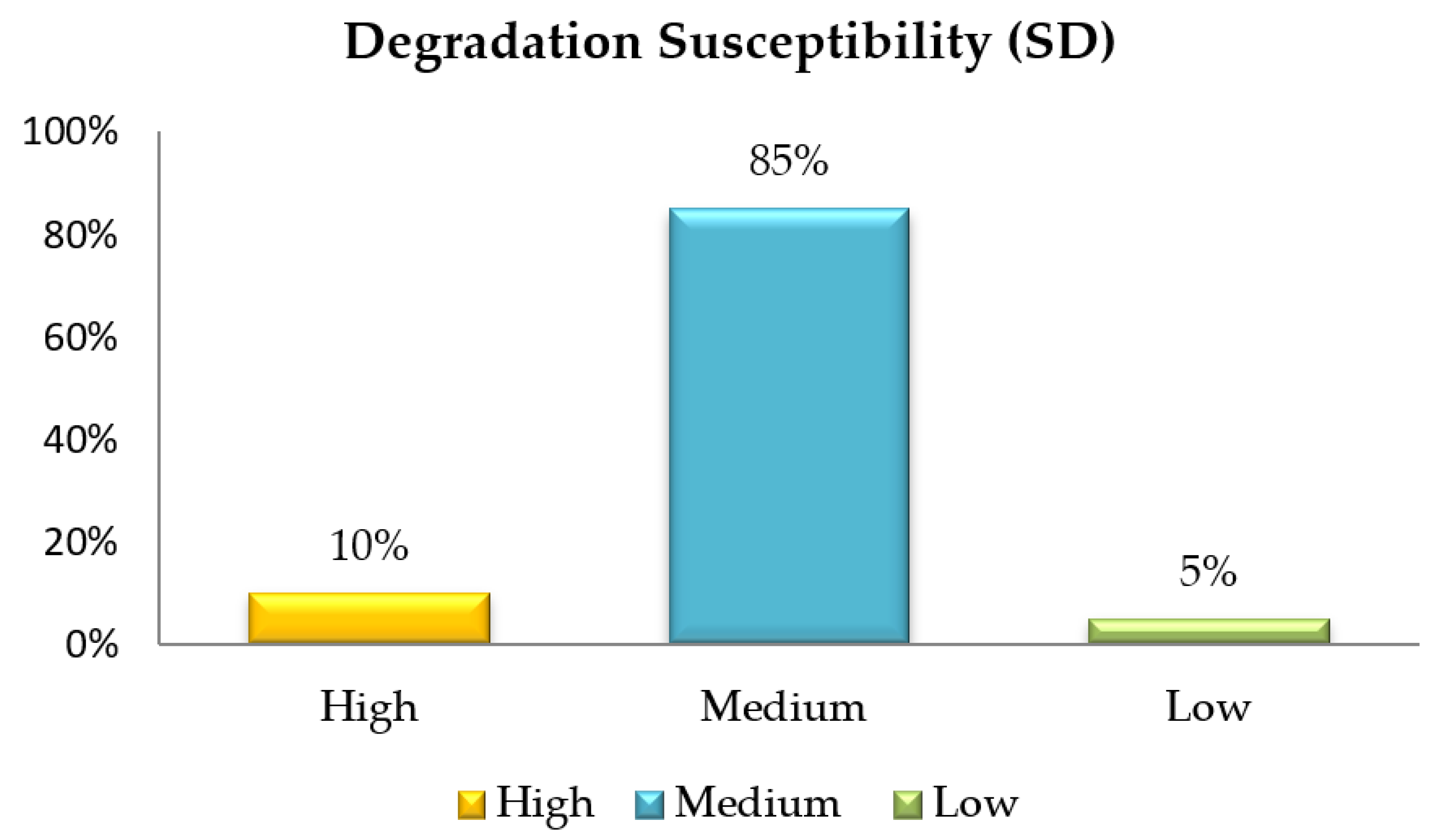
4.2.2. Degradation Susceptibility

After the assessment of interest values, the susceptibility to degradation was evaluated and classified into ‘high’, ‘medium’ and ‘low’ categories (Figure 10). Two geosites (10%), the Capas Volcánicas de Chimborazo (126.50), and the Cantera faldas Chimborazo (97.375) fall into the ‘high’ category. These sites are vulnerable due to their easy access and lack of indirect protection. Moreover, 17 geosites (85%) are within the ‘medium’ range. The clearest example of this group is the Cascada de Tambo, which obtained 66.50 points. In the ‘low’ range, there is only one geosite (Laguna de Colta, 12) (5% of the total).

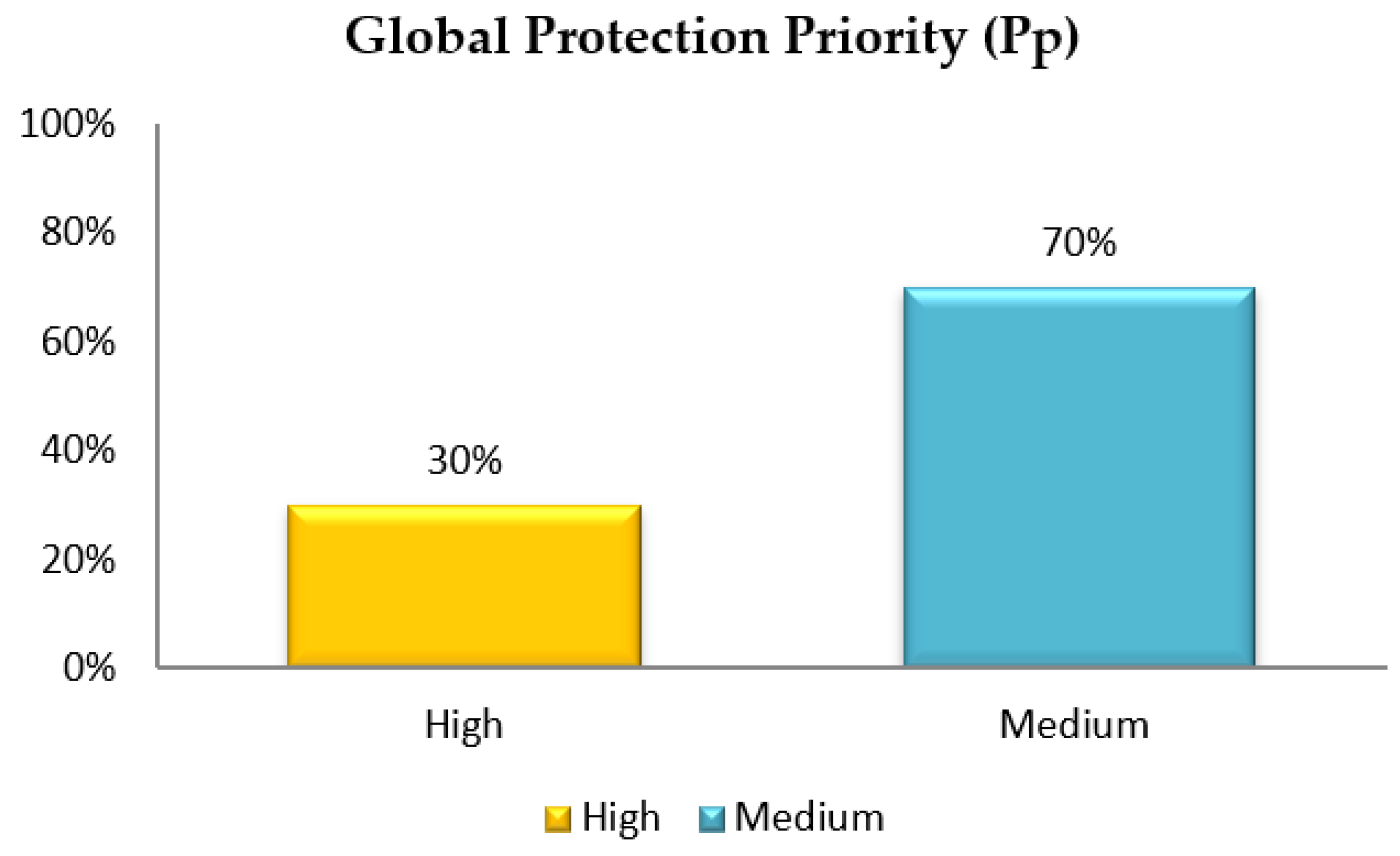
4.2.3. Global Protection Priority

With the obtained degradation susceptibility (DS) values, the global protection priority was calculated (Table 4). Moreover, 30% of the 20 geosites have a ‘high’ protection priority level, which indicates the need for urgent or short-term protection measures. The top three sites in this category are Capas Volcánicas de Chimborazo (43.05), Cantera faldas Chimborazo (37.53), and Cacha Community (24.14). The remaining 14 geosites have a ‘medium’ Pp level and require protection measures in the medium- or long-term (Figure 11).

4.3. SWOT Analysis

Table 5 shows a matrix with internal and external criteria. At the intersection of each row and column, strategies were designed to improve geosite conservation and protection.

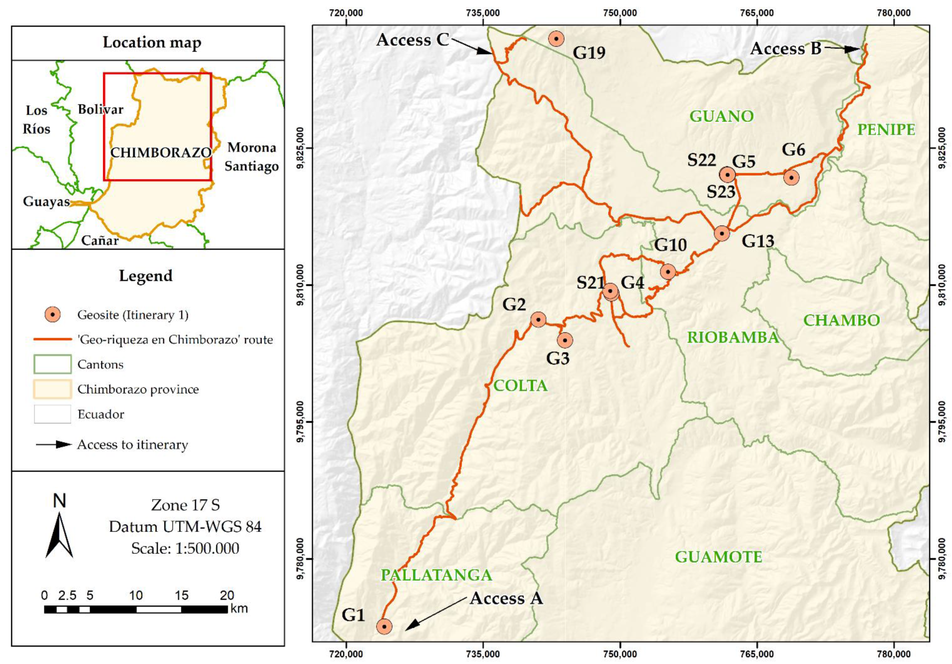
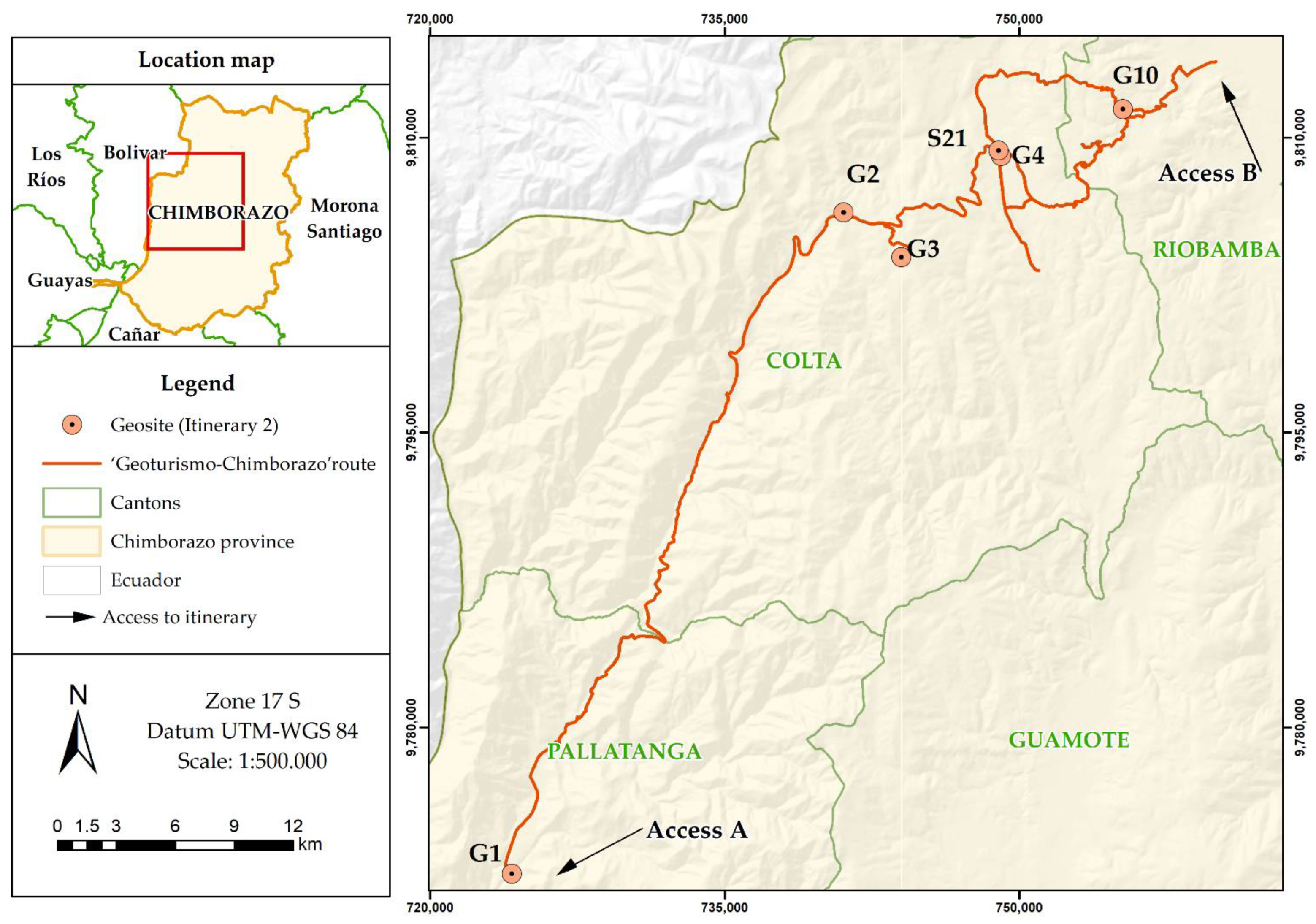
4.4. Proposed Itineraries Including Geosites

Based on the described data, the study proposes two travel itineraries as primary strategies for the promotion of geotourism development. Besides the geosites of this study, we also considered other outstanding cultural and tourist sites in the Chimborazo province. Itinerary # 01, named ‘Geo-riqueza en Chimborazo’, includes geosites of distinguished geological value and the most remarkable cultural sites of the area. Itinerary # 02, named ‘Geoturismo-Chimborazo’, includes geosites and tourist sites. The itineraries meet the following criteria:
  • Tourists can access each selected geosite in their own vehicle.
  • There exists an infrastructure with accommodation and restaurants within short distances.
  • Tourist and recreational activities are offered.
The itinerary ‘Geo-riqueza en Chimborazo’ has a high level of difficulty (requires good physical condition) and takes approximately three days to complete (Figure 12). For this itinerary, three possible accesses are proposed that allow visiting the geosites and connected cultural attractions and biodiversity features. Access (A) (Guayaquil-Riobamba road) is an example of a tourist route that begins with a visit to the Pallatanga canton, followed by the Colta canton and Riobamba, to end with the Guano canton where the Chimborazo volcano is the most impressive geosite of this route. Access (B) (Baños-Penipe road) starts from the Riobamba canton, goes on towards the coast, passing through Colta and Pallatanga; on the way, it is possible to appreciate geo-forms, such as El Altar Volcano, Carihuairazo Volcano, and Chimborazo Volcano (Figure S2). Access (C) (Arenal-San Juan road) starts from the Chimborazo Volcano (Figure S2c) and goes towards the Pallatanga fault. In this itinerary, sites such as the Balvanera Church, Guano Museum, and Monastery Ruins are included, which also have geology-related aspects. For example, the Balvanera Church was built with local basalt blocks (Figure S3).
The ‘Geoturismo-Chimborazo’ itinerary is of low difficulty level and takes one day. Two possible accesses are proposed. Access (A) begins from the Falla de Pallatanga and proceeds to the Riobamba canton. Access (B) starts from Riobamba and ends at the Falla Pallatanga (Figure 13).

5. Interpretation of Results and Discussion

Chimborazo province has geosites of great geological relevance that portray the dynamics of the Andean tectonics. Some examples are the Pallatanga geological fault that has been active for at least 600 ka [66], the volcanoes linked to the oblique convergence of the Nazca plate, to the lower inclination of the subduction zone resulting from the Carnegie Ridge [60], or those located to the south of the prolongation of the Grijalva fracture zone (e.g., El Altar) [80,81,82]. Globally, these geological characteristics are reflected in the selection of geosites. The sites were evaluated by the IELIG method [19], which proved that they can provide a basis for the development of geotourism in the area. Geosites can promote social development of territories with outstanding geological heritage [30,83].
In general, the existing volcanic geoheritage includes elements that are significant tourist attractions [84]. The diversity of these elements in the province of Chimborazo offers the opportunity to promote volcanology-related geo-education, awareness of geological hazards, as well as understanding the resilience of communities that have experienced the effects of volcanic activity. For example, the characteristic asymmetric shape of the Chimborazo Volcano (it has three peaks Whymper, Politécnica, and Nicolás Martínez) is a testimony of the great collapse of the Late Pleistocene and of the different stages of volcanic eruptions [57]. This collapse produced a debris avalanche, the deposits of which are home to more than 130,000 people today [56]. This geosite is a suitable example to demonstrate the magnitude of volcanic phenomena.
According to the average value of scientific, academic, and tourist interests, 25% of geosites have ‘very high’ interest and 75% have ‘high’ interest. In the assessment of scientific interest, the highest weight of the seven parameters considered by the IELIG methodology belongs to representativeness (30%). Seven out of the 20 studied geosites received the maximum score (point: 4) to this parameter, which is proof that they faithfully record the geological characteristics of the territory. One of the most important geosites is the Chimborazo volcano, the highest peak of the Northern Andes [57]. It has been the object of study, mainly in the fields of glacial retreat and volcanic activity, by several eminent geoscientists, such as Humboldt, a German explorer, the father of modern biogeography, who made early descriptions of Chimborazo [85], and influenced other scientists, such as Darwin and Whymper. Numerous scientific articles have been published about this geosite (e.g., [56,57,67,86,87,88]), and the Chimborazo volcano has the maximum value in scientific interest (Table 4).
In academic assessment, the parameter of educational values receives the highest weight (20%) of the 12 parameters. Regarding educational values, the geosites score between 2 and 4 points, which suggests that teaching materials are already in use or that the site has a potential at some level of the educational system (schools, colleges, universities). Sites such as the Chimborazo volcano, Pallatanga fault, or Paramo Guacona stand out. The landscape is characterized by high Andean moorlands (paramos). Geosites like the Páramo Guacona also have secondary values related to hydrogeology, the environment, or biodiversity, in addition to their evident geomorphological interest. Thus, they provide opportunities to develop educational initiatives related to geological heritage or environmental protection and conservation.
Beauty carries the highest weight (20%) among the 11 parameters of touristic assessment. Pozo Chingazo obtained the lowest score (1 point) to this parameter. The top three geosites regarding touristic interest are Volcán Chimborazo, Dunas Palmira, and Laguna de Colta, all of which are popular tourist destinations that also offer alternative activities, such as hiking, biking, and climbing (Volcán Chimborazo); camping, ecotourism, and photography (Dunas Palmira); or boating, kayaking, birdwatching, cycling, hiking, religious tourism, archaeological tourism, and camping (Laguna de Colta). Additionally, these geosites have good access roads and are associated with natural and cultural heritage elements. One example of this is the Chimborazo volcano where a wildlife reserve is home to endemic species, such as the critically endangered condor or Andean members of the camelid family (vicuñas, llamas, alpacas) besides other wild animals and plants. This site also hosts cultural activities, like the ‘Hieleros del Chimborazo’ route, which honors the millennium-old tradition of ice mining for culinary purposes, an activity in decline due to the retreat of the glacier.
Most geosites reached high scores in terms of scientific, educational, and tourist interests. Regarding degradation susceptibility and protection priority, however, the geosite with the highest score is the Capas Volcánicas de Chimborazo (G16) (Figure 4, Table 3). This geosite, which presents erosional unconformities and interlayered glacial deposits (Last Glacial Maximum) [57], has been an object of study by the local and international geoscientific community, mostly due to its ease of access, as it is adjacent to the main road (Arenal–San Juan). This condition also makes it exposed to anthropic activities, which increases its vulnerability. The least susceptible geosite is the Laguna de Colta (G4) (Figure S1, Table 3), a site of considerable dimensions, as its length exceeds 2.5 km, and it has an area of approximately 2 km2. The low susceptibility value suggests that this site is more resistant to anthropic actions probably due to the adequate plans for environmental management and ecotourism implemented here.
The geotourism envisioned for the analyzed geosites would combine landscape, entertainment, adventure, and gastronomy. Applying the biosecurity protocols demanded by the present situation (i.e., the COVID-19 pandemic), these plans could be put into action immediately and directly benefit local people. However, the geosites in the study area have one common threat: climate change. This problem has already caused alterations in one of the emblematic geosites of the area; between 1986 and 2013, the ice cover of the Chimborazo volcano decreased by 21% [86]. The effect of climate change on geosites is one of the ten priority areas of UNESCO’s Global Geopark program [89]. The loss of the last Chimborazo glacier, widely known because of the famous case of the last Chimborazo ice maker [87], is one of the cultural consequences of climate change. This example provides an opportunity to raise awareness in visitors and the surrounding community.
From the methodological point of view, semi-quantitative evaluation of geosites [2,19] is a useful approach to establish the bases of future geotourism perspectives in a given territory. One of its advantages is the identification of weak points in the analyzed interests, warranting objectivity in the study. For the obtained results to be more accurate, it is recommended to use a combination of several methods/methodologies [90]. However, the IELIG method [19], a reference method in Ibero-America according to the ASGMI (Ibero-American Association of Geological and Mining Studies), was the only methodology applied here, and it yielded satisfactory results [29].
The IELIG method can be used in a wide range of areas, not only for protected wildlands. It can be applied to biological corridors, cantons, and other cases where geological diversity can be considered a resource, as proven by geological interest point assessment studies in Ecuador [30,31,32,33,34] and in other countries [23,25]. The IELIG method has a special feature within its vulnerability indicators. Unlike other procedures, such as the Brilha method [2], the IELIG establishes a parameter named ‘Mining exploitation interest’ for the assessment of a factor that presents a threat to geological heritage. This parameter distinguishes sites of mining–metallogenic interest, geological formations that are products or are close to mining operations, sites of mineralogical interest, and sites of mining interest due to their excellent exposure.
The SWOT analysis is a useful tool that complements geosite assessment and seeks to examine the geotourism potential of each geosite. It provides essential information about the applicability and viability of geotourism development. It also prioritizes the necessity to relate all the potential of the area including biodiversity, geodiversity, and culture [4,91,92]. The SWOT analysis has become a basic method to comprehensively examine unstable situations in sustainable development and has been applied in various studies related to geoparks [93,94,95,96,97].
The SWOT analysis contributed to the development of proposals, such as geotourism promotion projects and travel itineraries [30]. It also highlighted the need for provincial, cantonal, and parochial authorities to collaborate with academics and businesses to advance the sustainable development of geosites. Finally, it resulted in the proposal of itineraries providing specific information about the routes (e.g., duration, visit sites, difficulty), their interests (e.g., scientific, academic, and tourist interests of the geosites), and impact (e.g., compatibility with current activities). The itineraries were based on the results of the described geosite assessment and on successful examples of geotourism development initiatives (e.g., [98,99,100]). They might have a substantial influence on the opportunities of rural sectors.

6. Conclusions

According to the results of the IELIG method applied in this study, 25% of the assessed geosites have ‘very high’ and 75% have ‘high’ average interest values taking into account their scientific, academic and tourist interests. The Chimborazo Volcano, known as ‘Earth’s Closest Point to the Sun’, obtained the highest score in the assessment. The DS values demonstrate that those geosites that are located close to infrastructures, such as main roads, or that lack any indirect protection, have high vulnerability values due to anthropic threats. Some geosites require immediate intervention. Moreover, 30% of the 20 geosites reaches a ‘high’ protection priority level, while the rest falls into the ‘medium’ protection priority category. Urgent protection measures should be implemented in the first group, but the rest of the sites meet the necessary conditions for geotourism development, such as accessibility and connectivity, other associated recreational activities, tourism facilities and services, and state of conservation. The IELIG method makes it possible to consider environmental-territorial characteristics in the assessment; therefore, it would be equally suitable for the evaluation of other areas in the region. Further studies, however, must be specifically adapted to the methodology of the central administration of the country.
The SWOT analysis shows that one of the greatest strengths of the selected geosites is their outstanding heritage value and their historical and cultural connections, through which they could offer excellent opportunities to foster geotourism and to boost the economy of Chimborazo province and the country. A key strategy involves geotourism promotion projects based on travel itineraries (such as those suggested in this article named ‘Geo-riquezas en Chimborazo’ and ‘Geoturismo-Chimborazo’) so that tourists can discover the geosites, their landscape, their culture, and enjoy a unique experience of knowledge, protection, and sustainable development. The two described travel itineraries are practical and feasible proposals that could become real alternatives to stimulate the development of the region while protecting the environment.
In general, the geotourism proposed here (itineraries) represents a sustainable enterprise that is compatible with the current socioeconomic activities (e.g., agriculture, livestock breeding, industry, trading, apiculture, and mining) of the area. Furthermore, these actions can contribute to the improvement of the quality of life of local people.

Supplementary Materials

The following are available online at https://0-www-mdpi-com.brum.beds.ac.uk/article/10.3390/su13094624/s1, Figure S1: One of the most visited geosites in the province of Chimborazo (a) “Colta” lagoon front landscape; (b) side landscape. Figure S2: three main geoforms of the Chimborazo province (a) Volcán Altar; (b) Volcán Carihuairazo; (c) Volcán Chimborazo; Figure S3: Representative geosite of the Chimborazo province (a) lateral part of the “Iglesia Balvanera”; (b) relic of the church; (c) front and striking part of the church.

Author Contributions

Conceptualization, P.C.-M., G.H.-F., C.B.-B., M.J.-M., A.M.-Z.; methodology, P.C.-M., G.H.-F., M.J.-M., N.P.-S.; F.M.-C.; investigation, P.C.-M., F.M.-C., G.H.-F., C.B.-B., M.J.-M., A.M.-Z., N.P.-S.; writing—original draft preparation, P.C.-M., F.M.-C., G.H.-F., C.B.-B., M.J.-M., A.M.-Z., N.P.-S.; E.B.; writing—review and editing, P.C.-M., F.M.-C., G.H.-F., C.B.-B., M.J.-M., N.P.-S.; supervision, P.C.-M., E.B. All authors have read and agreed to the published version of the manuscript.

Funding

This research was funded by the ‘Registry of geological and mining heritage and its impact on the defense and preservation of geodiversity in Ecuador’ academic research project by ESPOL University. CIPAT-01-2018.

Institutional Review Board Statement

Not applicable.

Informed Consent Statement

Not applicable.

Data Availability Statement

Not applicable.

Acknowledgments

This work has been possible thanks to support from BIRA Bienes Raices S.A. This work is based on previous initiatives sponsored by the Red Minería XXI (CYTED: 310RT0402, IGME). We also thank Timea Kovacs for her scientific suggestions and English editing.

Conflicts of Interest

The authors declare no conflict of interest.

References

  1. Gray, M.; Gordon, J.E.; Brown, E.J. Geodiversity and the ecosystem approach: The contribution of geoscience in delivering integrated environmental management. Proc. Geol. Assoc. 2013, 124, 659–673. [Google Scholar] [CrossRef]
  2. Brilha, J. Inventory and Quantitative Assessment of Geosites and Geodiversity Sites: A Review. Geoheritage 2016, 8, 119–134. [Google Scholar] [CrossRef] [Green Version]
  3. Boletín Oficial del Estado. LEY 42/2007, de 13 de diciembre, del Patrimonio Natural y de la Biodiversidad; BOE: Madrid, Spain, 2007; pp. 126–144. [Google Scholar]
  4. Urresty, C.; Rauld, R.; González, C.; Rozas, C. La incorporación del concepto de geodiversidad y geopatrimonio en la planificación territorial en Chile. In Proceedings of the XIV Congreso Geológico Chileno; AT4, Impacto de las Geociencias en la sociedad, La Serena, Chile, 4–8 October 2015; pp. 392–395. [Google Scholar]
  5. Medina, W. Importancia de la Geodiversidad. Método para el inventario y valoración del Patrimonio Geológico. Ser. Correlación Geológica 2015, 31, 57–72. [Google Scholar]
  6. Carrión, P.; Herrera, G.; Briones, J.; Sánchez, C. La Geodiversidad, una componente de desarrollo sostenible. J. Sci. Res. 2018, 3, 36–42. [Google Scholar]
  7. Carcavilla Urquí, L.; López Martínez, J.; Durán Valsero, J.J. Patrimonio Geológico y Geodiversidad: Investigación, Conservación, Gestión y Relación Cuadernos; Instituto Geológico y Minero de España (IGME): Madrid, Spain, 2007; ISBN 9788478407101. [Google Scholar]
  8. Erikstad, L. Geoheritage and geodiversity management-the questions for tomorrow. Proc. Geol. Assoc. 2013, 124, 713–719. [Google Scholar] [CrossRef]
  9. Herrera-Franco, G.; Montalván-Burbano, N.; Carrión-Mero, P.; Jaya-Montalvo, M.; Gurumendi-Noriega, M. Worldwide Research on Geoparks through Bibliometric Analysis. Sustainability 2021, 13, 1175. [Google Scholar] [CrossRef]
  10. Prosser, C.D.; Díaz-Martínez, E.; Larwood, J.G. The conservation of geosites. In Geoheritage; Reynard, E., Brilha, J., Eds.; Elsevier: Amsterdam, The Netherlands, 2018; pp. 193–212. [Google Scholar]
  11. Jakubowski, K.J. Geological heritage and museums. In Proceedings of the Geological Heritage Concept, Conservation and Protection Policy in Central Europe; Polish Geological Institute Special Papers: Warsaw, Poland, 2004; pp. 21–28. [Google Scholar]
  12. Reis, J.; Póvoas, L.; Barriga, F.J.A.S.; Lopes, C.; Santos, V.F.; Ribeiro, B.; Cascalho, J.; Pinto, A. Science Education in a Museum: Enhancing Earth Sciences Literacy as a Way to Enhance Public Awareness of Geological Heritage. Geoheritage 2014, 6, 217–223. [Google Scholar] [CrossRef]
  13. UNESCO. List of UNESCO Global Geoparks (UGGp). Available online: http://www.unesco.org/new/en/natural-sciences/environment/earth-sciences/unesco-global-geoparks/list-of-unesco-global-geoparks/ (accessed on 19 August 2020).
  14. Bentivenga, M.; Cavalcante, F.; Mastronuzzi, G.; Palladino, G.; Prosser, G. Geoheritage: The Foundation for Sustainable Geotourism. Geoheritage 2019, 11, 1367–1369. [Google Scholar] [CrossRef] [Green Version]
  15. Salamanca, J.V.; Alberruche, E.; Urquí, L.C.; Martínez, E.D.; Cortés, Á.G.; De Domingo, A.G.; Ponce, D.; Gil, D.L. Guía Metodológica Para la Integración del Patrimonio Geológico en la Evaluación de Impacto Ambiental; Dirección General de Calidad y Evaluación Ambiental, Ministerio de Agricultura, Alimentación y Medio Ambiente & IGME: Madrid, Spain, 2012. [Google Scholar]
  16. Berrezueta, E.R.; Domínguez-Cuesta, M.J.; Carrión, P.; Berrezueta, T.; Herrero, G. Propuesta metodológica para el aprovechamiento del patrimonio geológico minero de la zona Zaruma-Portovelo (Ecuador). Trab. Geol. 2006, 26, 103–109. [Google Scholar]
  17. Albani, R.A.; Mansur, K.L.; Carvalho, I.D.S.; Santos, W.F.S. dos Quantitative evaluation of the geosites and geodiversity sites of João Dourado Municipality (Bahia–Brazil). Geoheritage 2020, 12. [Google Scholar] [CrossRef]
  18. Voth, A. Los geoparques y el geoturismo: Nuevos conceptos de valorización de recursos patrimoniales y desarrollo regional. In Proceedings of the XI Coloquio Ibérico de Geografía. La Perspectiva Geográfica Ante los Nuevos Retos de la Soiedad y el Medio Ambiente en el Contexto Ibérico; Interdisciplinary Group for Critical Studies and Latin America (GIECRYAL): Alcalá de Henares, Spain, 2008; pp. 1–15. [Google Scholar]
  19. García-Cortés, Á.; Carcavilla Urquí, L.; Apoita Mugarza, B.; Arribas, A.; Bellido, F.; Barrón, E.; Delvene, G.; Díaz Martínez, E.; Díez, A.; Durán, J.J.; et al. Documento Metodológico para la Elaboración del Inventario Español de Lugares de Interés Geológico (IELIG); Instituto Geológico y Minero de España: Madrid, Spain, 2013. [Google Scholar]
  20. Pérez-Umaña, D.; Quesada-Román, A. Metodología para la valoración y evaluación de geomorfositios en Costa Rica. Rev. Geográfica América Cent. 2018, 1, 117–135. [Google Scholar] [CrossRef] [Green Version]
  21. Henriques, M.H.; Dos Reis, R.P.; Brilha, J.; Mota, T. Geoconservation as an emerging geoscience. Geoheritage 2011, 3, 117–128. [Google Scholar] [CrossRef] [Green Version]
  22. Carrión-Mero, P.; Loor-Oporto, O.; Andrade-Ríos, H.; Herrera-Franco, G.; Morante-Carballo, F.; Jaya-Montalvo, M.; Aguilar-Aguilar, M.; Torres-Peña, K.; Berrezueta, E. Quantitative and Qualitative Assessment of the “El Sexmo” Tourist Gold Mine (Zaruma, Ecuador) as A Geosite and Mining Site. Resources 2020, 9, 28. [Google Scholar] [CrossRef] [Green Version]
  23. Mehdioui, S.; El Hadi, H.; Tahiri, A.; Brilha, J.; El Haibi, H.; Tahiri, M. Inventory and Quantitative Assessment of Geosites in Rabat-Tiflet Region (North Western Morocco): Preliminary Study to Evaluate the Potential of the Area to Become a Geopark. Geoheritage 2020, 12, 1–17. [Google Scholar] [CrossRef]
  24. Rocha, J.; Brilha, J.; Henriques, M.H. Assessment of the geological heritage of Cape Mondego Natural Monument (Central Portugal). Proc. Geol. Assoc. 2014, 125, 107–113. [Google Scholar] [CrossRef] [Green Version]
  25. Corbí, H.; Fierro, I.; Aberasturi, A.; Sánchez Ferris, E.J. Potential Use of a Significant Scientific Geosite: The Messinian Coral Reef of Santa Pola (SE Spain). Geoheritage 2018, 10, 427–441. [Google Scholar] [CrossRef]
  26. Cantero-Quesada, J.M. Territorio, turismo y senderos temáticos: El caso de Baños de la Encina, Jaén. In Patrimonio Cultural y Desarrollo Territorial; Aranzadi, T.R., Ed.; Thomson Reuters Aranzadi: Cizur Menor, Spain, 2016; pp. 277–308. [Google Scholar]
  27. Palacio Prieto, J.L.; de Castro Martínez, G.F.; González, E.M. Geotrails in the mixteca alta UNESCO Global Geopark, Oaxaca, Mexico. Cuad. Geográficos Univ. Granada 2019, 58, 111–125. [Google Scholar]
  28. Palladino, G.; Prosser, G.; Bentivenga, M. The Geological Itinerary of Sasso di Castalda: A Journey into the Geological History of the Southern Apennine Thrust-belt (Basilicata, Southern Italy). Geoheritage 2013, 5, 47–58. [Google Scholar] [CrossRef]
  29. Asociación de Servicios de Geología y Minería de Iberoamérica (ASGMI). Bases para el Desarrollo Común del Patrimonio Geológico en los Servicios Geológicos de Iberoamérica; ASGMI: Salta, Argentina, 2018. [Google Scholar]
  30. Franco, G.H.; Mero, P.C.; Carballo, F.M.; Narváez, G.H.; Bitar, J.B.; Torrens, R.B. Strategies for the development of the value of the mining-industrial heritage of the Zaruma-Portovelo, Ecuador, in the context of a geopark project. Int. J. Energy Prod. Manag. 2020, 5, 48–59. [Google Scholar] [CrossRef]
  31. Carrión-Mero, P.; Ayala-Granda, A.; Serrano-Ayala, S.; Morante-Carballo, F.; Aguilar-Aguilar, M.; Gurumendi-Noriega, M.; Paz-Salas, N.; Herrera-Franco, G.; Berrezueta, E. Assessment of geomorphosites for geotourism in the northern part of the “ruta escondida” (Quito, Ecuador). Sustainability 2020, 12, 1–23. [Google Scholar] [CrossRef]
  32. Herrera, G.; Carrión, P.; Briones, J. Geotourism potential in the context of the Geopark Project for the development of Santa Elena Province, Ecuador. In Proceedings of the WIT Transactions on Ecology and the Environment; Passerini, G., Marchettini, N., Eds.; WIT Press: Southampton, UK, 2018; Volume 217, pp. 557–568. [Google Scholar]
  33. Ayala Granda, A.J.; Carrión Mero, P.C.; Gurumendi Noriega, M.; Herrera Franco, G.; Morante Carballo, F.; Paz Salas, N.A. Registro y valoración de geomorfositios de la zona sur de la Ruta Escondida, como alternativa de fomento a la geoconservación del paisaje en la región Caranqui-Ecuador. In Proceedings of the 18th LACCEI International Multi-Conference for Engineering, Education, and Technology: Engineering, Integration, and Alliances for A Sustainable Development” “Hemispheric Cooperation for Competitiveness and Prosperity on a Knowledge-Bas, Latin American and Caribbean Consortium of Engineering Institutions, Virtual Edition. 27–31 July 2020; pp. 27–31. [Google Scholar]
  34. Morante-Carballo, F.; Herrera-Narváez, G.; Jiménez-Orellana, N.; Carrión-Mero, P. Puyango, Ecuador Petrified Forest, a Geological Heritage of the Cretaceous Albian-Middle, and Its Relevance for the Sustainable Development of Geotourism. Sustainability 2020, 12, 6579. [Google Scholar] [CrossRef]
  35. Fernández, M.P.; Timón, D.L.; Marín, R.G. El geoturismo como estrategia de desarrollo en áreas rurales deprimidas: Propuesta de geoparque villuercas, Ibores, Jara (Extremadura). Bol. Asoc. Geogr. Esp. 2011, 485–497. [Google Scholar]
  36. Dowling, R. Geotourism’s Global Growth. Geoheritage 2011, 3, 1–13. [Google Scholar] [CrossRef]
  37. Chylińska, D. The Role of the Picturesque in Geotourism and Iconic Geotourist Landscapes. Geoheritage 2019, 11, 531–543. [Google Scholar] [CrossRef] [Green Version]
  38. Dowling, R.K. Global Geotourism—An Emerging Form of Sustainable Tourism. Czech. J. Tour. 2014, 2. [Google Scholar] [CrossRef] [Green Version]
  39. Sanz, J.; Zamalloa, T.; Maguregi, G.; Fernandez, L.; Echevarria, I. Educational Potential Assessment of Geodiversity Sites: A Proposal and a Case Study in the Basque Country (Spain). Geoheritage 2020, 12, 1–13. [Google Scholar] [CrossRef]
  40. Martín Roda, E. El proceso turístico: Sujetos, agentes y efectos. Espac. Tiempo Forma. Ser. VI Geogr. 2001, 209–222. [Google Scholar] [CrossRef] [Green Version]
  41. Herrera-Franco, G.; Montalván-Burbano, N.; Carrión-Mero, P.; Apolo-Masache, B.; Jaya-Montalvo, M. Research Trends in Geotourism: A Bibliometric Analysis Using the Scopus Database. Geosciences 2020, 10, 379. [Google Scholar] [CrossRef]
  42. Newsome, D.; Dowling, R. Geoheritage and Geotourism. In Geoheritage; Elsevier: Amsterdam, The Netherlands, 2018; pp. 305–321. [Google Scholar]
  43. Sousa, B.B.; Malheiro, M.A.; Liberato, P.; Liberato, D. Managing Market Segments with Environmental Concerns: Geotourism And Geodiversity. In Proceedings of the 35th IBIMA Conference Education Excellence and Innovation Management: A 2025 Vision to Sustain Economic Development during Global Challenges, IBIMA, Seville, Spain, 1–2 April 2020; pp. 9682–9690. [Google Scholar]
  44. Dowling, R.K.; Newsome, D. Geotourism: Sustainability, Impacts and Management; Elsevier/Heineman Publisher: Oxford, UK, 2006. [Google Scholar]
  45. Costa, S.P.; Sonaglio, K.E. Análisis del comportamiento resiliente de los gestores de turismo. Estud. Perspect. Tur. 2020, 29, 331–348. [Google Scholar]
  46. Ponce, W.P.P.; Pérez, J.F.R.; Hernández, I.P. Resiliencia del turismo ante fenómenos naturales. Comparación de casos de Cuba y Ecuador. COODES 2018, 6, 225–240. [Google Scholar]
  47. Arredondo García, M.C.; Aguilera, J.C.L.; Ávila Serrano, G.E.; Sánchez Cortez, J.L.; Figueroa Beltrán, C.; Mata Perelló, J.M. Determinación del patrimonio geológico, cultural e histórico en la creación de geoparques como instrumento de conservación y desarrollo local. Re Met. Rev. Soc. Española Def. Patrim. Geológico Min. 2013, 45–52. [Google Scholar]
  48. Arellano, J. Implicaciones del medioambiente del pleistoceno tardío y holoceno temprano para la ubicación de ocupaciones humanas precerámicas en la sierra central del Ecuador. Sarange 1997, 24, 119–134. [Google Scholar]
  49. Coello Zamora, D.M. Los Escenarios Naturales Formados por la Actividad Volcánica del Tungurahua y su Contribución en la Generación de un Producto Orientado al Fomento del Geoturismo de las Provincias de Tungurahua y Chimborazo; Universidad Técnica de Ambato: Ambato, Ecuador, 2015. [Google Scholar]
  50. Mendoza, B.; Chidichimo, F.; Straface, S. Estima del volumen de agua subterránea proveniente de los deshielos del nevado Chimborazo. In Proceedings of the XXV Congreso Latinoamericano de Hidráulica, Santiago, Chile, 25–29 August 2014; pp. 1–10. [Google Scholar]
  51. Lozano, P.; Armas, A.; Machado, V. Estrategias para la conservación del ecosistema páramo en Pulinguí San Pablo y Chorrera Mirador, Ecuador. Enfoque UTE 2016, 7, 55–70. [Google Scholar] [CrossRef] [Green Version]
  52. Barba, D. Estudio Vulcanólogico del Complejo Volcánico Chimborazo; Escuela Politécnica Nacional (EPN): Quito, Ecuador, 2016. [Google Scholar]
  53. INEC. Población y Demografía. Available online: https://www.ecuadorencifras.gob.ec/censo-de-poblacion-y-vivienda/ (accessed on 12 January 2021).
  54. Winkler, W.; Villagómez, D.; Spikings, R.; Abegglen, P.; Tobler, S.; Egüez, A. The Chota basin and its significance for the inception and tectonic setting of the inter-Andean depression in Ecuador. J. S. Am. Earth Sci. 2005, 19, 5–19. [Google Scholar] [CrossRef]
  55. Inguaggiato, S.; Hidalgo, S.; Beate, B.; Bourquin, J. Geochemical and isotopic characterization of volcanic and geothermal fluids discharged from the Ecuadorian volcanic arc. Geofluids 2010, 10, 525–541. [Google Scholar] [CrossRef]
  56. Bernard, B.; de Vries, B.W.; Barba, D.; Leyrit, H.; Robin, C.; Alcaraz, S.; Samaniego, P. The Chimborazo sector collapse and debris avalanche: Deposit characteristics as evidence of emplacement mechanisms. J. Volcanol. Geotherm. Res. 2008, 176, 36–43. [Google Scholar] [CrossRef]
  57. Samaniego, P.; Barba, D.; Robin, C.; Fornari, M.; Bernard, B. Eruptive history of Chimborazo volcano (Ecuador): A large, ice-capped and hazardous compound volcano in the Northern Andes. J. Volcanol. Geotherm. Res. 2012, 221–222, 33–51. [Google Scholar] [CrossRef]
  58. Huddart, D.; Stott, T. The Andes. In Adventure Tourism; Springer International Publishing: Cham, Switzerland, 2020; pp. 291–324. [Google Scholar]
  59. Chimborazo, el Volcán de Ecuador Más Alto que el Everest (si se Mide Desde el Centro de la Tierra). Available online: https://www.bbc.com/mundo/noticias/2016/04/160407_por_que_chimborazo_ecuador_mas_lejos_centro_tierra_que_el_everest_dgm (accessed on 21 March 2021).
  60. Hall, M.L.; Samaniego, P.; Le Pennec, J.L.; Johnson, J.B. Ecuadorian Andes volcanism: A review of Late Pliocene to present activity. J. Volcanol. Geotherm. Res. 2008, 176, 1–6. [Google Scholar] [CrossRef]
  61. Vallejo Cruz, C. Evolution of the Western Cordillera in the Andes of Ecuador (Late Cretaceous-Paleogene). Ph.D. Thesis, ETH Zürich, Zürich, Switzerland, 2007. [Google Scholar]
  62. Luzieux, L.D.A.; Heller, F.; Spikings, R.; Vallejo, C.F.; Winkler, W. Origin and Cretaceous tectonic history of the coastal Ecuadorian forearc between 1° N and 3° S: Paleomagnetic, radiometric and fossil evidence. Earth Planet. Sci. Lett. 2006, 249, 400–414. [Google Scholar] [CrossRef]
  63. Jaillard, É.; Lapierre, H.; Ordóñez, M.; Toro, J.; Amórtegui, A.; Vanmelle, J. Accreted oceanic terranes in Ecuador: Southern edge of the Caribbean Plate? Geol. Soc. Lond. Spec. Publ. 2009, 328, 469–485. [Google Scholar] [CrossRef] [Green Version]
  64. Berrezueta, E.; López, K.; González-Menéndez, L.; Ordóñez-Casado, B.; Benítez, S. Ophiolitic rocks and plagiorhyolites from SW Ecuador (Cerro San José): Petrology, geochemistry and tectonic setting. J. Iber. Geol. 2021, 1–20. [Google Scholar] [CrossRef]
  65. Alvarado, A.; Audin, L.; Nocquet, J.M.; Jaillard, E.; Mothes, P.; Jarrín, P.; Segovia, M.; Rolandone, F.; Cisneros, D. Partitioning of oblique convergence in the Northern Andes subduction zone: Migration history and the present-day boundary of the North Andean Sliver in Ecuador. Tectonics 2016, 35, 1048–1065. [Google Scholar] [CrossRef] [Green Version]
  66. Bablon, M.; Quidelleur, X.; Samaniego, P.; Le Pennec, J.-L.; Audin, L.; Jomard, H.; Baize, S.; Liorzou, C.; Hidalgo, S.; Alvarado, A. Interactions between volcanism and geodynamics in the southern termination of the Ecuadorian arc. Tectonophysics 2019, 751, 54–72. [Google Scholar] [CrossRef]
  67. Spikings, R.A.; Crowhurst, P.V. (U–Th)/He thermochronometric constraints on the late Miocene–Pliocene tectonic development of the northern Cordillera Real and the Interandean Depression, Ecuador. J. S. Am. Earth Sci. 2004, 17, 239–251. [Google Scholar] [CrossRef]
  68. Barba, D.; Robin, C.; Samaniego, P.; Eissen, J.-P. Holocene recurrent explosive activity at Chimborazo volcano (Ecuador). J. Volcanol. Geotherm. Res. 2008, 176, 27–35. [Google Scholar] [CrossRef]
  69. Baize, S.; Audin, L.; Winter, T.; Alvarado, A.; Pilatasig Moreno, L.; Taipe, M.; Reyes, P.; Kauffmann, P.; Yepes, H. Paleoseismology and tectonic geomorphology of the Pallatanga fault (Central Ecuador), a major structure of the South-American crust. Geomorphology 2015, 237, 14–28. [Google Scholar] [CrossRef]
  70. Egüez, A.; Gaona, M.; Albán, A. Mapa Geológico de la República del Ecuador. ESCALA 1:1 000 000; Ministerio de Minería y Instituto Nacional de Investigación Geológico Minero Metalúrgico: Quito, Ecuador, 2017; Available online: https://www.geoenergia.gob.ec/mapas-geologicos/ (accessed on 16 April 2021).
  71. Villares, F.; Garcia-Casco, A.; Blanco-Quintero, I.F.; Montes, C.; Reyes, P.S.; Cardona, A. The Peltetec ophiolitic belt (Ecuador): A window to the tectonic evolution of the Triassic margin of western Gondwana. Int. Geol. Rev. 2020, 1–25. [Google Scholar] [CrossRef]
  72. Spikings, R.; Cochrane, R.; Villagomez, D.; Van der Lelij, R.; Vallejo, C.; Winkler, W.; Beate, B. The geological history of northwestern South America: From Pangaea to the early collision of the Caribbean Large Igneous Province (290–75Ma). Gondwana Res. 2015, 27, 95–139. [Google Scholar] [CrossRef]
  73. Jaillard, E.; Ordoñez, M.; Suárez, J.; Toro, J.; Iza, D.; Lugo, W. Stratigraphy of the late Cretaceous–Paleogene deposits of the cordillera occidental of central ecuador: Geodynamic implications. J. S. Am. Earth Sci. 2004, 17, 49–58. [Google Scholar] [CrossRef] [Green Version]
  74. ESPOL University. Registry of Geological and Mining Heritage and Its Impact on the Defense and Preservation of Geodiversity in Ecuador; ESPOL University: Guayaquil, Ecuador, 2018. [Google Scholar]
  75. Dyson, R.G. Strategic development and SWOT analysis at the University of Warwick. Eur. J. Oper. Res. 2004, 152, 631–640. [Google Scholar] [CrossRef]
  76. Riobamba. Lo Mejor. Available online: https://riobamba.com.ec/es-ec/chimborazo/riobamba/volcanes/volcan-chimborazo-a07694d29 (accessed on 12 March 2021).
  77. Winckell, A. Los grandes rasgos del relieve en el Ecuador. In Los Paisajes Naturales del Ecuador; CEDIG: Quito, Ecuador, 1997; pp. 3–13. [Google Scholar]
  78. Quinde Martínez, P.D.; Reinoso Angulo, E. Estudio de peligro sísmico de Ecuador y propuesta de espectros de diseño para la Ciudad de Cuenca. Rev. Ing. Sísmica 2016, 1–26. [Google Scholar] [CrossRef] [Green Version]
  79. Valdivieso Ramache, C.D. La Justicia Indígena y su Incidencia en la Vulneración de los Derechos Humanos, en la Comunidad de Cacha, Parroquia de Yaruquies, Cantón Riobamba, Provincia de Chimborazo a Partir del 2008; Universidad Nacional de Chimborazo (UNACH): Riobamba, Ecuador, 2016. [Google Scholar]
  80. Yepes, H.; Audin, L.; Alvarado, A.; Beauval, C.; Aguilar, J.; Font, Y.; Cotton, F. A new view for the geodynamics of Ecuador: Implication in seismogenic source definition and seismic hazard assessment. Tectonics 2016, 35, 1249–1279. [Google Scholar] [CrossRef] [Green Version]
  81. Narvaez, D.F.; Rose-Koga, E.F.; Samaniego, P.; Koga, K.T.; Hidalgo, S. Constraining magma sources using primitive olivine-hosted melt inclusions from Puñalica and Sangay volcanoes (Ecuador). Contrib. Mineral. Petrol. 2018, 173, 80. [Google Scholar] [CrossRef]
  82. Ancellin, M.-A.; Samaniego, P.; Vlastélic, I.; Nauret, F.; Gannoun, A.; Hidalgo, S. Across-arc versus along-arc Sr-Nd-Pb isotope variations in the Ecuadorian volcanic arc. Geochem. Geophys. Geosystems 2017, 18, 1163–1188. [Google Scholar] [CrossRef]
  83. Carrión Mero, P.; Herrera Franco, G.; Briones, J.; Caldevilla, P.; Domínguez-Cuesta, M.; Berrezueta, E. Geotourism and Local Development Based on Geological and Mining Sites Utilization, Zaruma-Portovelo, Ecuador. Geosciences 2018, 8, 205. [Google Scholar] [CrossRef]
  84. Erfurt-Cooper, P. Geotourism in Volcanic and Geothermal Environments: Playing with Fire? Geoheritage 2011, 3, 187–193. [Google Scholar] [CrossRef]
  85. Humboldt, A. Geognostische und physikalische Beobachtungen über die Vulkane des Hochlandes von Quito. Ann. Phys. Chem. 1837, 116, 161–193. [Google Scholar] [CrossRef]
  86. La Frenierre, J.; Mark, B.G. Detecting Patterns of Climate Change at Volcán Chimborazo, Ecuador, by Integrating Instrumental Data, Public Observations, and Glacier Change Analysis. Ann. Am. Assoc. Geogr. 2017, 107, 979–997. [Google Scholar] [CrossRef]
  87. Vizuete, D.D.C.; Montoya, A.V.G.; Yepez, C.B.R.; Velásquez, C.R.C.; Marcu, M.V.; Borz, S.A. Perception and use of cultural ecosystem services among the Andean communities of Chimborazo reserve. Environ. Eng. Manag. J. 2019, 18, 2705–2718. [Google Scholar]
  88. Noboa, A.M.Y. Empty spaces that are full of cultural history: An innovative proposal for the management of a protected area of Chimborazo volcano (Ecuador). J. Prot. Mt. Areas Res. Manag. 2020, 12, 43–49. [Google Scholar] [CrossRef]
  89. UNESCO. Top 10 Focus Areas of UNESCO Global Geoparks. Available online: http://www.unesco.org/new/en/natural-sciences/environment/earth-sciences/unesco-global-geoparks/top-10-focus-areas/ (accessed on 13 March 2021).
  90. Ruban, D.A. Quantification of geodiversity and its loss. Proc. Geol. Assoc. 2010, 121, 326–333. [Google Scholar] [CrossRef]
  91. Brocx, M.; Semeniuk, V. Geoheritage and geoconservation—History, definition, scope and scale. J. R. Soc. West. Aust. 2007, 90, 53–87. [Google Scholar]
  92. Carcavilla Urquí, L. Patrimonio Geológico y Geodiversidad: Investigación, Conservación, Gestión y Relación con los Espacios Naturales Protegidos; IGME: Madrid, Spain, 2006. [Google Scholar]
  93. Horacio, J.; Muñoz-Narciso, E.; Sierra-Pernas, J.M.; Canosa, F.; Pérez-Alberti, A. Geo-Singularity of the Valley-Fault of Teixidelo and Candidacy to Geopark of Cape Ortegal (NW Iberian Peninsula): Preliminary Assessment of Challenges and Perspectives. Geoheritage 2019, 11, 1043–1056. [Google Scholar] [CrossRef]
  94. Endy Marlina, E. Geotourism as a Strategy of Geosite Empowerment Towards the Tourism Sustainability in Gunungkidul Regency, Indonesia. Int. J. Smart Home 2016, 10, 131–148. [Google Scholar] [CrossRef]
  95. Kubalíková, L.; Kirchner, K. Geosite and Geomorphosite Assessment as a Tool for Geoconservation and Geotourism Purposes: A Case Study from Vizovická vrchovina Highland (Eastern Part of the Czech Republic). Geoheritage 2016, 8, 5–14. [Google Scholar] [CrossRef]
  96. Kubalíková, L. Assessing Geotourism Resources on a Local Level: A Case Study from Southern Moravia (Czech Republic). Resources 2019, 8, 150. [Google Scholar] [CrossRef] [Green Version]
  97. Cai, Y.; Wu, F.; Han, J.; Chu, H. Geoheritage and Sustainable Development in Yimengshan Geopark. Geoheritage 2019, 11, 991–1003. [Google Scholar] [CrossRef]
  98. Martínez-Graña, A.M.; Serrano, L.; González-Delgado, J.A.; Dabrio, C.J.; Legoinha, P. Sustainable geotourism using digital technologies along a rural georoute in Monsagro (Salamanca, Spain). Int. J. Digit. Earth 2017, 10, 121–138. [Google Scholar] [CrossRef]
  99. Wrede, V.; Mügge-Bartolović, V. GeoRoute Ruhr—A Network of Geotrails in the Ruhr Area National GeoPark, Germany. Geoheritage 2012, 4, 109–114. [Google Scholar] [CrossRef]
  100. Simón-Porcar, G.; Martínez-Graña, A.; Simón, J.L.; González-Delgado, J.Á.; Legoinha, P. Ordovician Ichnofossils and Popular Architecture in Monsagro (Salamanca, Spain): Ethnopaleontology in the Service of Rural Development. Geoheritage 2020, 12, 76. [Google Scholar] [CrossRef]
Figure 1. Location of Chimborazo province: (a) regional location of the study area within the NW zone of the South American margin; (b) local setting of Chimborazo province showing the main volcanoes.
Sustainability 13 04624 g001
Figure 2. Geological map of the province of Chimborazo [70]: (a) tectonic map of Ecuador based on [65], showing major fault segments, active faults and delimitation of the continental basement. Abbreviations: NAS: North Andean Sliver; Py: Pisayambo zone, QFS: Quito active Fault System; (b) regional geology map of the Chimborazo province showing the main structures [70].
Sustainability 13 04624 g002
Figure 3. Outline of the applied methodology.
Sustainability 13 04624 g003
Figure 4. Location map of sites of geological interest. Falla Pallatanga (G1); Páramo Guacona (G2); Páramo de Navag (G3); Laguna de Colta (G4); Mirador de Guano (G5); Pozo Chingazo (G6); Cascada de Tambo (G7); Lahar Tungurahua (G8); Columnas de basalto de Guano (G9); Comunidad Cacha (G10); Laguna Comunidad Quero (G11); Huellas Megaterios de Riobamba (G12); Loma de Quito (G13); Termas Guayllabamba (G14); Cantera faldas Chimborazo (G15); Capas Volcánicas de Chimborazo (G16); Cascada La Chorrera (G17); Dunas Palmira (G18); Volcán Chimborazo (G19); Volcán El Altar (G20).
Sustainability 13 04624 g004
Figure 5. Examples of geosites: (a) Dunas Palmira (G18 in Table 3); (b) Capas Volcánicas de Chimborazo (G16 in Table 3); (c) Huellas de Mastodontes de Riobamba (G12 in Table 3); (d) Termas Guayllabamba (G14 in Table 3).
Sustainability 13 04624 g005
Figure 6. Examples of geosites of great scientific interest: (a) Volcán Chimborazo (G19 in Table 3); (b) Páramo Guacona (G2 in Table 3).
Sustainability 13 04624 g006
Figure 7. Examples of geosites of great academic interest: (a) Falla Pallatanga (G1 in Table 3); (b) Comunidad Cacha (G10 in Table 3).
Sustainability 13 04624 g007
Figure 8. Examples of views from geosite The Mirador de Guanos (G5 in Table 3). (a) Panoramic view of the Guano city; (b) face of chief Toca monolith (warrior of the Puruhá culture).
Sustainability 13 04624 g008
Figure 9. Tabulation of interests of the geosites as: (a) scientific; (b) academic; and (c) touristic.
Sustainability 13 04624 g009
Figure 10. Values of the degradation susceptibility (DS) analysis.
Sustainability 13 04624 g010
Figure 11. Values of global Protection Priority (Pp).
Sustainability 13 04624 g011
Figure 12. Suggested Itinerary, “Geo-riqueza en Chimborazo”, consists of the 12 sites: Falla Pallatanga (G1), Páramo Guacona (G2), Páramo de Navag (G3), Laguna de Colta (G4), Iglesia Balvanera (S21), Comunidad Cacha (G10), Loma de Quito (G13), Mirador Guano (G5), Pozo Chingazo (G6), Museo Guano (S22), Ruinas Monasterio de Asunción (S23), Volcán Chimborazo (G19).
Sustainability 13 04624 g012
Figure 13. Suggested itinerary ‘Geoturismo-Chimborazo’ consists of 6 sites: Falla Pallatanga (G1), Páramo Guacona (G2), Páramo de Navag (G3), Laguna de Colta (G4), Iglesia Balvanera (S21), Comunidad Cacha (G10).
Sustainability 13 04624 g013
Table 1. Established parameters to assess scientific (Sc.), academic (Ac.), and touristic (To.) interests based on [19]. Interest value rank (0, 1, 2, 3, or 4). Weight (constant values in %). Interpretation: maximum (400), very high (267–400), high (134–266), medium (50–134), low (<50).
ValueInterest of the Geosites
Scientific (Sc.)Academic (Ac.)Touristic (To.)
Parameters ValueWeightValueWeightValueWeight
Representativeness0 to 4300 to 450 to 40
Standard or reference site1050
Knowledge of the site1500
State of conservation1050
Conditions of observation1055
Scarcity, rarity1550
Geological diversity10100
Educational values0200
Logistics infrastructure0155
Population density055
Possibilities for public outreach (accessibility)01510
Size of site0015
Association with other natural elements055
Beauty0520
Informative value0015
Possibility of recreational and leisure activities005
Proximity to other places of interest005
Socio-economic environment0010
Total (weight) 100 100 100
TotalSc. = value × weightAc. = value × weightTo. = value × weight
Table 2. Parameters of degradation susceptibility (DS) and weighs of each parameter. Interpretation of DS: maximum (400), very high (400–200), high (199–68), medium (67–13), low (<13).
ParameterFragility (Fr.)
ValueWeight
Geosite size0 to 440
Vulnerability to looting30
Natural hazards30
Total (weight) 100
Total (Fr.)Fr. = value × weight
ParameterVulnerability (Vul.)
ValueWeight
Proximity to infrastructures0 to 420
Mining exploitation interest15
Protected area designation15
Indirect protection15
Accessibility15
Ownership status10
Population density5
Proximity to recreational areas5
Total (weight) 100
Total (Vul.)Vul. = value × weight
Table 3. List of potential geosites in the study area, typological and classification.
No.GeositesType of Geological Interest
G1Falla Pallatanga (geologic fault)Structural
G2Páramo Guacona (moorland)Geomorphological
G3Páramo de Navag (moorland)Geomorphological
G4Laguna de Colta (lagoon)Geomorphological
G5Mirador de Guano (viewpoint)Geomorphological
G6Pozo Chingazo (water well)Hydrogeological
G7Cascada de Tambo (waterfall)Geomorphological
G8Lahar Tungurahua (lahar)Geomorphological
G9Columnas de basalto de Guano (basalt columns)Volcanic
G10Comunidad Cacha (landscape-museum)Geomorphological
G11Laguna Comunidad Quero (lagoon)Geomorphological
G12Huellas de Mastodontes de Riobamba
(mastodon footprints)
Paleontological
G13Loma de Quito (hill)Geomorphological
G14Termas Guayllabamba (hot springs)Hydrogeological
G15Cantera faldas Chimborazo (mine) Mining
G16Capas Volcánicas de Chimborazo
(Tephra fallout deposit)
Volcanic
G17Cascada La Chorrera (waterfall)Geomorphological
G18Dunas Palmira (dunes-desert)Geomorphological
G19Volcán Chimborazo (volcano)Volcanic
G20Volcán El Altar (volcano) Volcanic
Table 4. Assessment geosites in terms of scientific (Sc.), academic (Ac.), touristic (To.), and average (Av.) interest, susceptibility to degradation (DS), vulnerability due to anthropic threats (Vul.), and scientific (Pp (Sc.)), academic (Pp (Ac.)), touristic (Pp (To.)), and global (Pp) protection priority.
No.GeositesSc.Ac.To.Av.DSPp (Sc.)Pp (Ac.)Pp (To.)Pp
G1Falla Pallatanga (geologic fault)360305280315.0023.2518.8313.5211.3914.42
G2Páramo Guacona (moorland)265310255276.6722.509.8813.519.1410.76
G3Páramo de Navag (moorland)220205245223.3322.506.815.918.447.01
G4Laguna de Colta (lagoon)255260330281.6712.004.885.078.175.95
G5Mirador de Guano (viewpoint)195225260226.6743.7510.4013.8418.4814.05
G6Pozo Chingazo (water well)215185140180.0052.5015.1711.236.4310.63
G7Cascada de Tambo (waterfall)215210205210.0066.5019.2118.3317.4718.33
G8Lahar Tungurahua (lahar)335225195251.6743.8830.7713.8810.4317.37
G9Columnas de basalto de Guano (basalt columns)250235190225.0043.7517.0915.109.8713.84
G10Comunidad Cacha
(landscape-museum)
350305270308.3340.6331.1023.6218.5124.14
G11Laguna Comunidad Quero
(lagoon)
185175195185.0052.2511.1810.0012.4211.18
G12Huellas Megaterios de Riobamba (megaterios footprints)290190260246.6729.2515.376.6012.3611.12
G13Loma de Quito (hill)195225165195.0044.0010.4613.927.4910.46
G14Termas Guayllabamba (hot springs)200215275230.0063.3815.8418.3129.9520.95
G15Cantera faldas Chimborazo (mine)285230230248.3397.3849.4332.1932.1937.53
G16Capas Volcánicas de Chimborazo (Tephra fallout deposit)220205275233.33126.5038.2733.2359.7943.05
G17Cascada La Chorrera (waterfall)195175190186.6724.505.824.695.535.34
G18Dunas Palmira (dunes-desert)205240345263.3324.756.508.9118.4110.73
G19Volcán Chimborazo (volcano)380370370373.3315.7514.2113.4813.4813.72
G20Volcán El Altar (volcano)255210315260.0019.507.925.3712.098.24
Table 5. SWOT analysis of the study area. The matrix combines internal features (i.e., strengths and weaknesses) identified by the letters (S) and (W) and external features (i.e., opportunities and threats) identified by letters (O) to (T).
Internal
Environment
Strengths (S)Weaknesses (W)
External
Environment
S1. Variety of attractions, such as waterfalls, rock formations, paleontological fragments.
S2. Easy access.
S3. Unique and relevant landscape beauty.
S4. Valuable geological heritage.
W1. Limited promotion and brochures about geosites and geotourism.
W2. Lack of knowledge and disinterest of the population.
W3. Lack of design of routes or circuits with geological information to visit the attractions.
W4. Some attractions are not covered by geosite protection and conservation.
Opportunities (O)Strategies: S + OStrategies: W + O
O1. Boost the economy of the province.
O2. Creation of routes.
O3. Diverse and flexible tourist alternatives.
O4. Geotourism as a state policy.
S1.O2. Develop plans focused on promoting attractions through geological routes for tourists.
S4.O4. Promote active national cooperation through initiatives that lead to better conservation of natural, cultural, and intangible heritage.
W1.O1. Generate geotourism promotion projects that serve as an alternative to improve the population’s economic conditions and seek to promote integrated tourism.
W4.O4. Pursue scientific studies and research on intervention methods that allow the country to face the dangers that threaten its heritage.
Threats (T)Strategies: S + TStrategies: W + T
T1. Lack of private economic resources that facilitate the implementation of programs and projects associated with geological tourism.
T2. Environmental degradation.
T3. High-quality demand in tourism services to confront the COVID-19.
S1.T2. Promote the development of conservation and protection plans for geosites with the community’s support to prevent deterioration.
S3.T1. Promote both national and international recognition of assets through cooperation with government entities.
W2.T3. Involve experts in preservation and conservation issues to develop initiatives that prevent deterioration and improve the quality of tourism at geosites.
W3.T1. Use marketing tools appropriately to keep the destination’s spirit alive and thereby achieve its development in the tourism market.
Publisher’s Note: MDPI stays neutral with regard to jurisdictional claims in published maps and institutional affiliations.

