1. Introduction
1.1. Educator City-Sustainable City. Iconographic Options
Cities have been the great protagonists of the different processes of civilization. Fundamental concepts such as “politics”, “civility”, “civilization”, “citizenship”, “urbanism”, which typify the essences of the cooperation of people, are in relation to Polis, Civis or Urbs; concepts that refer us to the city understood as a complex space of human coexistence. Ultimately civilizations have been generated in the experiences of human coexistence in the context of cities [
1,
2]. Indeed, the city, as a complex transtemporal system for more than 5000 years, has involved not always easy coexistence since the joint-life of large human groups has involved pacts, discussion, collaboration, and rules of coexistence comparable to the laws. The humanizing challenge of cities, the art of living together, has been constant in history. Cities continue to be productive cultural and governance hubs, and they maintain a fundamental role in the development of humanity. Cities are important because they educate, with greater or lesser fortune, in cooperation, coexistence, and, obviously, in “citizenship”. The city is an educator by definition, and it forges the citizenship of young generations, including children [
3]. However explicit actions are also important. The educative function of cities, from an axiological point of view, and, according to the dominant values of a community, are fundamental in the construction and development of citizenship. The educational and instructive processes that help to understand the background of the city, its history, and its heritage, are also determinants since they facilitate an empirical experience and help to interpret and decide, with criteria of rationality, which is also a powerful component of citizenship [
4]. The heritage of cities (the part of the past that is part of the present, which value is given) is random. The consideration of what should be regarded as heritage, and therefore preserved, depends on the world view of society at any given time. In general, in democratic societies, the tendency is to consider heritage as an asset that helps to understand, act and decide in the present, and that it is necessary to protect. In this sense, heritage contributes to building quality citizenship, aware of its background and the multiple problems (concrete and complex) that derive from the relationship between human beings, urban territory, technologies, and productive systems. On the other hand, heritage, especially that of “historical” cities, becomes directly an economic factor that can develop wealth from cultural industries or cultural tourism [
5]. To promote civic, functional, and economic factors interchangeably, the conception of the city as an “educational city” is also important [
6]. In this perspective, heritage should be seen as an asset, potential or real, contributing to the development of quality citizenship and as a factor for the generation of wealth. That is why heritage education in urban areas, in the key of sustainability, is important and this education-instruction requires making understandable the most diverse aspects and assets of heritage to broad sectors of the citizenry, including school environments [
7]. In the present work we focus on the historical-archaeological building material heritage: buildings, monuments, structures, and urban infrastructure that are those that most clearly define the image and tangible historical landscape of the city [
8,
9,
10].
The urban landscape undergoes a continuous transformation, and in the processes of change, the elements considered “heritage” can mutate or even disappear. A city cannot keep its landscape frozen, but it is also out of the discussion that the relevant elements and heritage landscapes (for their value, aesthetics, uniqueness, uniqueness, or significance) must be preserved [
11]. This brings us to another important scenario: the sustainability of urban heritage. The architectural artifacts of yesteryear were built to fulfill certain functions that disappear over time. This reality implies the need to grant them new functionalities, and, that these are congruent with the aesthetic and architectural values of the artifact. Sustainability policies and a culture of heritage governance are important. Heritage contributes powerfully to the imagination and identity of urban environments and their people. Indeed, the global sustainability of the city also requires the sustainability of the heritage to be considered or conserved. However, heritage maintenance must be based on activities compatible and consistent with the heritage object, which are not necessarily at odds with new technological, productive, or habitable trends. However, the culture of sustainability of heritage also depends, directly, on the degree of civility that society manifests towards heritage. Additionally, it is in this sense that heritage education, citizenship, and sustainability converge on the same horizon and constitute the same meta-concept [
7]. We start from the basis that, to value the heritage, have an opinion, and decide on it, knowledge is necessary. This knowledge of the urban heritage landscape will be more effective if it affects broad layers of the population. In this sense, extensive techniques and educational-instructional resources must be established, which impact citizenship that, often, has unequal previous knowledge regarding the history and heritage of the city. What is proposed in this article is, precisely, the development of didactic techniques, based on new historical iconographies, developed from the technologies of the moment, that contribute to presenting the urban heritage in an understandable way to broad sectors of the population, and that the resulting greater knowledge affects the greater citizen quality, preservation and sustainability of the heritage [
12]. The images generated in the past (old photos, plans of other times, engraved, etc) help to understand the historical city. However, what is proposed in the work is the generation of new urban iconographies and the establishment of new didactic models, using the technology of the moment, intending to design images that explain the city, its history, and its transformations. This new iconography will be useful for analyzing the past and visible heritage in the urban landscape, understanding and valuing it, and deciding about its future [
13,
14,
15,
16].
1.2. Working Hypothesis
To explain the city, its urban past, and its architectural heritage, there are multiple languages and sources (literary, documentaries, musicals, objects, oral, etc.); however, it is cartographic and iconographic/photographic sources that allow a more global, accurate and faster perception and understanding of the urban landscape over time. The research group DIDPATRI (Didactics of Heritage) of the University of Barcelona, which was carried out between 2005 and 2020, has used photographic, cartographic, and iconographic sources of different periods, to explain the historical evolution of urban spaces. The main contribution has been the elaboration of criteria for the development of new iconographies to present and explain a certain historical landscape or a certain urban heritage and has worked interchangeably from real cases or in the design of imaginary cases used as a model [
17,
18]. The working hypotheses have been based on the conviction that the new technologies of 3D spatial representation allow the didactic recreation of textures and volumes of heritage, archaeological and historical urban spaces [
19,
20] however, in turn, these visions of the past can be optimized and complemented by 2D developments in which environmental, furniture, and anthropic elements can be incorporated. These options, which surpass the brief information provided by monochrome volumetric 3D, contextualize the spaces according to human activities and furniture elements, and provide more understandable information by enabling a more diverse set of assumptions to be identified by facilitating more meaningful learning and a greater impact on people’s learning, the development of sustainable options for the uses of urban heritage. The main objective of the research has been to establish the criteria and conceptual protocols needed to generate 3D models of representation of historical, archaeological, and heritage urban spaces. Generation should not be complex concerning design and, along with complementary 2D developments, should provide truthful models of the city and its heritage elements at different historical times. It was hoped that these strategies (provide understandable historical images of the city) contributed to the formation of citizenship (an easier acquisition of knowledge), which, in turn would favor the development of attitudes and values that would contribute a more sustainable position of heritage, its conservation, to its use and enjoyment.
1.3. General Objectives
Scientific, technological and didactic objectives were set in different fields:
(a) Conceptual design. Define, generate, experiment, and evaluate the characteristics of different models and didactic prototypes of restitution/reconstruction/iconographic recreation, of urban spaces (cities), with their heritage elements, in different periods.
(b) Design of iconographic techniques. Generate, test, and evaluate models of didactic iconography of historical urban environments built based on diverse sources and contributions: historical documentation and cartography; photographs; geophysical prospecting; scanners and photogrammetry; hypothetical restitutions and 3D prints; historical recreation; 2D from matte painting and concept art; kinetic images; scenographies; multisensory and expression complements (soundscapes, musical, literary, plastic expression, etc.).
(c) Emerging technologies. Assess the possibilities of iconography generated from basic CGI (Computed-Generated Imagery) software, to build images of the past, conceived as intermediary artifacts that are suitable, to contribute to the interpretation of diverse typologies of urban heritage environments, and replicable in different types of media (museography artifacts, publications, audiovisual, web, apps, telephony, etc.). Establish possible protocols regarding the design processes and the elements to be integrated into the different models (depending on the object of knowledge) and their uses.
(d) Socialization of knowledge. To propose digital iconographic prototypes, which are socially sustainable and economical for their production and their possibility of transformation. Develop replicas in the most diverse contexts, supports, and functions: publications; web environments; computer games; apps, panels; didactic materials; mobile telephony; augmented reality; virtual reality; sets; 3D printing, etc., for areas such as education, cultural industries, cultural tourism, games, edutainment, etc.
(e) Heritage and sustainable urban landscapes. Propose the sustainability of iconographic models developed from different logics. Economically sustainable in terms of production costs and processing possibilities, incorporating new knowledge. Sustainable as long as the product can reapply on different media and in different environments. Sustainable in so far as it contributes to heritage education that impacts on proactive citizenship in terms of heritage preservation. Influence the cultural industries related to the heritage cluster so that they can have quality iconographic elements that enable users to understand heritage equipment.
(f) Education in citizenship. Incardinate the interventions and cases developed in a context of Public Archaeology, Public History, and Civic Education, promoting democratic values and enhancing the creation of wealth from a sustainable use and enjoyment of heritage. Define characteristics and uses of iconographic platforms in collaboration with professionals involved in the management or use of heritage spaces (conservatives, technicians, teachers, guides, etc.). Define participatory design and public archaeology processes to adjust research to social demands.
2. Materials and Methods
2.1. Cartographic Representation and Didactic Reprentation
Cartographic techniques have seen great advances since the 19th century through the incorporation of the system of level curves and the development of software from photo planes and satellite photography during the 20th century [
21,
22]. The maps of the present collect historical determinants and the maps of the past inform us of a certain place, in a certain temporal moment. We can also approximate heritage or historical urban spaces, based on cartography, which can use different media (printed on paper, digital, etc.) and different scales, according to the dimensions of the urban space to be represented. However, planimetry requires a high level of abstraction to be understood as the structures are represented from a vertical perpendicular point of view and are generally replaced by contours that usually do not have chronological references. It is not easy to make a historical reading of the landscape from cartography. For wide sectors of users and school users, maps and plans are not optimal didactic tools to imagine what an urban space was like in another time or what the arrangement and function of the urban heritage was.
Various strategies were developed to access users with few possibilities to interpret cartography. During the 16th century, Wyngaerde produced magnificent series of views of cities from an oblique aerial perspective. He believed that from this point of view sufficiently holistic visions were provided that demonstrated a rough idea of the city [
23]. The pictures and engravings with bird’s eye view of the cities continued to be cultivated during the seventeenth and eighteenth centuries [
24,
25]. Later, during the 19th and 20th centuries, other strategies began to be used: panoramas, accurate engravings, and oblique aerial photographs, to show the cities of the moment. The passion for the generation of understandable images of historical urbanism reached very important levels in Mussolini’s Italy. He also built, in 1933, a gigantic model of Rome on a scale of 1:250; work that began the archaeologist Italo Gismondi and that can still be contemplated today in the
Museum of the Roman Civilitta, in Rome [
26].
More recently, some magazines aimed at the general public, such as National Geographic, proceeded to develop oblique iconographies that recreated and reconstructed archaeological spaces and cities of another time from Infogrames. These types of journals financed scientific expeditions and were concerned with making the scope of their work known to the general public [
27,
28]. During the 1970s, these experiences influenced the generation of cases and explicitly didactic models. Authors such as D. Macaulay surprised the world by offering, from relatively simple drawings, the evolution of an imagined model of a Roman city [
29]. Equally extraordinary iconographers such as Jean Claude Golvin offered magnificent views of the cities and heritage artifacts of the ancient world [
30]. In addition, the contributions made during the 1990s by F.X. Hernàndez and J. Ballonga are noteworthy [
31], because for the first time, they illustrate evolutionary models of cities based on broad chronological paths, with successive enlargements of the same city. All these authors, who focused especially on didactic iconography and urban heritage, developed their models and their didactic proposals based on a traditional technology: pencil, nib, and watercolor. Somehow, they prepared the ground for what came to be called “virtual archaeology” which focused mainly on the recreation of ancient urban complexes [
32].
2.2. The Inadequacy of “Virtual Archaeology”
In the early 21st century, the development of CGI (Computed-Generated Imagery) systems also influenced the world of archaeology. The so-called “virtual archaeology” was developed, which consisted of making imaginary surveys and recreations of archaeological spaces, more or less grounded, from different sources and different typologies [
33]. What was being pursued conceptually was not different from what had already been tried in the late decades of the 20th century by authors such as Golvin, Mcaulay, Hernàndez, Ballonga, and others. However, now, similar projects were proposed from a computer tool with new advantages and possibilities. Digital iconography paved the way, understood as an opportunity to build comprehensible images of the past [
34,
35]. Hypothetical 3D reconstructions of historical, archaeological, and heritage spaces, including urban enclosures, proliferated [
36,
37]. It is worth mentioning the significant impulse that virtual archaeology brought to the creation of images from the past, which were increasingly realistic [
38].
This new emerging subdiscipline of archaeology focused on the creation of digital images from archaeological information [
39,
40]. Digital archaeological reconstructions advanced significantly, but little didactic theory was generated. Virtual archaeology had little impact on education. There was no significant reflection on the possibilities of digital iconography to interpret or explain the past, although the number of experiences grew [
41,
42,
43,
44].
As new computer developments and mobile telephony burst into schools, exponentially multiplying the possibilities of access to past and past iconography, the consideration of images as an educational tool became a strategic option [
45,
46,
47]. However, history teachers did not take advantage of the new situation to massively incorporate iconography into the teaching and learning of history.
On the other hand, it should be noted that the advances in software enabled the emergence of techniques previously used by the film industry, such as matte painting, to become determinants in the generation of historical images [
48]. These techniques also involved the presentation of large historic urban enclosures, limited in terms of graphical extension, by the perimeters of the spaces themselves, by the dimensions of the screens, and by the impressive memory that it implied to reproduce, in 3D, and with details, a large urban area.
Digital iconography reached a spectacular development from computer games and especially thanks to the engines that drove them [
49]. Animated 3D recreations made in the film industry also demonstrated their extraordinary possibilities. The recreation of historical or para-historical landscapes in films and video games was constant and concentrated the know-how of digital illustration. The most ambitious projects achieved good results but in exchange for large investments and high degrees of professionalization [
50]. Digital iconography produced with limited resources and applied in parallel to didactic and educational products, or outreach products, could not compete with the quality achieved in films and games, which, in turn, were widely socialized from the market. This involved a complementary problem (especially in the young population sectors) as high-quality digital products were available on the market at affordable prices, in contrast to the limited products offered by museums and educational environments. Proximity iconography could not compete with historical iconography exhibiting games such as Assassins Creed [
51].
In this context, the interests of the DIDPATRI research group focused on the use of affordable programs: Autocad, Maya, 3DSMax; SketchUp, Blender and ZBrush, etc., to experiment and generate replicas or urban models and functional heritage elements, with an acceptable or good formal quality and with a high didactic value from the conceptual point of view [
52]. The proposals focused mainly on the organization of content, techniques, and criteria for the organization of images. In any case, it was considered important to manage the basic programs of the moment from which to build quality 3D complexes.
This was important as it was intended to assess whether any center (research institute, educational center, museum, interpretation center, town hall, etc.) that was interested in developing didactic iconography could aspire to build its 3D iconographic program without excessive costs. Naturally, the horizon opened up by new museum options such as virtual reality, augmented reality, or virtual museums, incited great interest to the proposal [
53,
54]. The usefulness of the digital proposals was finally confirmed by the emergence of the COVID19 pandemic in 2020, as it put on the agenda the need to advance the development of virtual museography.
2.3. Credible and Sustainable Iconography
From the didactic point of view supported by DIDPATRI, 3D images generated from virtual archaeology presented several problems. The images normally presented buildings well finished, homogeneous, without texture, and often monochrome. The streets were clean, and there was no furniture or human elements. The environmental aspects: smoke, fog, meteors, etc., were not reflected either. The resulting ones were usually aseptic, and therefore unreal. This impression of environmental weightlessness was reflected when 3D works materialized in 2D sheets or when moving videos were generated. In some cases, and by the pressure of the tradition of the architects’ studios, the houses and the set of volumetry of the urban environments were presented from white color (or a uniform color). At the same time, some archaeologists also argued that, in the representation of unsubstantiated data, it was preferable to use white. Naturally, this line of argument had problems, especially in the archaeological spaces reconstructed digitally, since, although it was true that the textures and colors of the walls could be unknown, this did not justify “no color” as a scientific option. On the other hand, it was no less true that the heights represented could also be questionable. In any case, much of the resulting products were unrealistic, and therefore uneducated.
Attempts to integrate human figures were also difficult, as during the first two decades of the 21st century the generation and movement of 3D bodies in animation was complex and unattainable in real-time. On the other hand, from an aesthetic point of view, the 3D bodies presented a rigidity that made them not credible. It should be noted that the modeling of human figures in 3D and interactive representation was improved from the appearance of software such as MakeHuman, Character Creator, Poser, Blender and Substance Painter, Sketchfab, etc., but improvements were not considered sufficient.
This point contrasted with the productions achieved in computer games, elaborated with very high budgets, which did integrate environmental aspects and furniture and human in movement in an increasingly realistic and credible way. Moreover, as we have indicated, these products were (and are) very popular, especially among young people. Competing with them is not an easy thing. Museums, research institutes, interpretation centers, municipalities, etc., had to look for options that would allow them to search for a high level of quality to present their spaces in situ [
55]. On the other hand, from 2021, the great improvements in the software of spatial and human representation, with the irruption of new programs such as
Unreal (used spectacularly in
The Mandalorian), Daz Studio 3D; World creator, and MetaHuman Creator, etc., opens up new and extraordinary possibilities for didactic iconography. Based on the variables exposed, DIDPATRI aimed to generate guidelines and a conceptual ordering in the generation of sustainable iconographies from all points of view; products that could be built from market software that is not excessively complex and does not require excessive specialization. On the other hand, the resulting iconographies should be able to reappear in different media: panels, web, videos, apps, paper publications, etc [
56]. All this should also be understood as sustainability: an iconographic product of moderate cost that could be replicated successively, capable of transforming and adapting to new situations. Naturally, the prediction regarding the need of cultural and educational institutions (virtual museums, virtual teaching, etc.) to extend complementary networks of a virtual nature [
57] fit, in a key of sustainability, with such premonitory approaches, (especially from 2020, with the impact of Covid19, when they acquired greater relevance).
These initiatives were developed based on existing software between 2013 and 2020. The products designed and tested by DIDPATRI were developed based on criteria that were hypothesized in a road map, defined based on empirical experience, comprising different phases.
- (a)
Work was carried out to design 3D recreations of historic urban spaces of medium dimensions, not exceeding one square km. These recreations had to follow the criteria of maximum realism. Already in the initial developments of the 3D, the buildings had to be textured and environmentally friendly to the extent possible, always retouching the lines straight. In the absence of sufficient archaeological information, parallel cases or neutral solutions should be considered. The 3D-recreated urbanism had to be precise enough to generate detailed virtual flights along the perimeter, over its buildings, and the most representative singular places. The precision of the design should allow selecting various spaces to generate 2D images with the presence of furniture and anthropic elements. It was renounced to integrate into the 3D the human figures and the furniture elements.
- (b)
From the base 3D, it should be possible to generate various complementary products. The mechanics had to be to select a stage or place from the 3D: street, singular building, housing, etc. and obtain a 2D. The generated 2D image implied a certain fixed point of view that allowed typing the place with furniture and anthropic elements using matte-painting techniques and from Photoshop-type programs. It should also be possible to proceed to engrave video in chroma and to superimpose it on the 2D generated from the 3D to obtain a kinetic image.
- (c)
The combination of these three products:
2.4. The Methodological Framework
From a methodological point of view, the meta-project of didactic iconography of urban spaces (understood as a project) had an interdisciplinary character, but its structuring features (define iconographic models for the understanding of historical-archaeological urban spaces) gave prominence to the Sciences of Education and, especially, to the Didactics of the Social Sciences. The project was situated at a crossroads between the disciplines that deal with learning and teaching, and those that define the body of contents (factual and procedural) that work in the heritage environment and in a unique way in history and archaeology. All of this is contextualized in an ICT environment [
59].
The objective of the research was focused on the generation of models in didactic iconography that allowed us to understand and understand spaces, concepts, and techniques especially relevant from archaeological, historical, or heritage evidence in urban contexts. The methodology/technique of central research was that of design and evaluation of didactic models and prototypes; which were, complemented and reinforced by the technique of experiments, and the set of the proposal also integrated doses of triangulation (diverse perspectives of analysis and assessment by different actors in time and space). The methodology called “Design and Evaluation of Teaching Materials” in the didactic environment was proposed, which is also related to the quasi-experimental method. From the point of view of educational research, the project had qualitative comprehensive components. It was proposed as a project with a vocation of application (educational city; sustainability; teaching; cultural industries) to develop in collaboration with different agents (mainly educational environments and cultural institutions). The proposal could be considered in a qualitative methodology environment for decision-making and change. Although the result involved educational centers and teaching materials for formal education, the research process also took place outside the classroom. In this sense, research was also considered in a non-formal context and with strong social repercussions.
A considerable part of the research was empirical in its approach to iconographic models, since it was based on facts that could be verified and contrasted concerning their functionality. Building an iconographic platform was a technical challenge that touched on the problem of the comprehensibility of the past and heritage. The information options (iconic requirements, cartographic requirements, etc.) driving the proposals were important, but the didactic feasibility also depended on exploring the possibilities of new emerging technologies and combining them in a didactic and comprehensive perspective. The didactic feasibility was conceived as a sum of techniques that operated in the environment of the study of a certain patrimonial object and the socialization of its knowledge (georadar images, scanners, photogrammetry, hypothetical recreations in 3D, digital printing, museography, matte painting, and concept art to contextualize, historical recreation to take models, etc.). The interaction between techniques and formats was the one that could generate digital images of synthesis, static or kinetic, that allow to enhance and enable the understanding from different options fixed by the protocolization of iconographic models.
On the other hand, the options were considered based on their interactive, playful, and didactic possibilities, which gave greater prominence to the formal design of the iconographic platforms. In this sense, the empirical and experimental dimensions should be considered as an important component in the overall articulation of the project. About the purpose of the research, it was felt that it should preferably be located in the field of applied research, while its purpose was the resolution of practical problems and the optimization of strategies and resources. However, a certain dimension of basic research could also be considered since proposals of general and universal validity were generated. The rules of usability or comprehensibility extracted from the iconographic prototypes to be designed constituted a model replicable to the most different realities to facilitate the understanding of different heritage typologies.
2.5. Medieval and Modern Urban Heritage. Cases and Models
Already during the decades of the 1980s and 1990s, from the environment of what would be the group DIDPATRI, different iconographic experiences were developed to establish didactic models of the evolution of cities and urban landscapes. The proposals were strongly oriented towards primary and secondary education and were developed in the context of the Educational Reform of Catalonia [
31]. Validated experience in school settings was extrapolated to a general user profile. The most notable contribution was the design of several imaginary cities
Barmi,
a city in southern Europe [
60];
Lebek, a City of Northern Europe [
61];
San Rafael, a city of Central America [
62]. These models were developed with analog means and had remarkable educational success. One of his main contributions was to present credibly the growth of a city, within some limits of printing, and always maintaining the same scale. This was achieved by the use of very distant vanishing points, right and left of the drawing, causing a distorting effect that can hardly be obtained by computer means.
The experience of DIDPATRI also led to the recreation, with analog technology, of urban areas of different periods, among the most singular being the Iberian town of “Alorda Park” in Calafell (Tarragona); the Final Bronze site of “Els Vilars d’Arbeca” (Lleida) or the Roman city of Tarraco (Tarragona). The first experiences of the group in terms of recreations of archaeological spaces with computer resources were made from various pre-Roman towns in the province of Salamanca (Spain). The castros of “Merchanas”, “Yecla de Yeltes” and “Saldeana” (Salamanca) were digitally reconstructed [
63].
Between 2013 and 2020 the group worked on various projects that involved historical recreation of urban and heritage sites. The most important works were carried out at the Born site in Barcelona and in the Pyrenean city of la Seu d’Urgell (Lleida) but also in the towns of el Masnou (Barcelona); Lleida; Figueres (Girona); Roses (Girona).
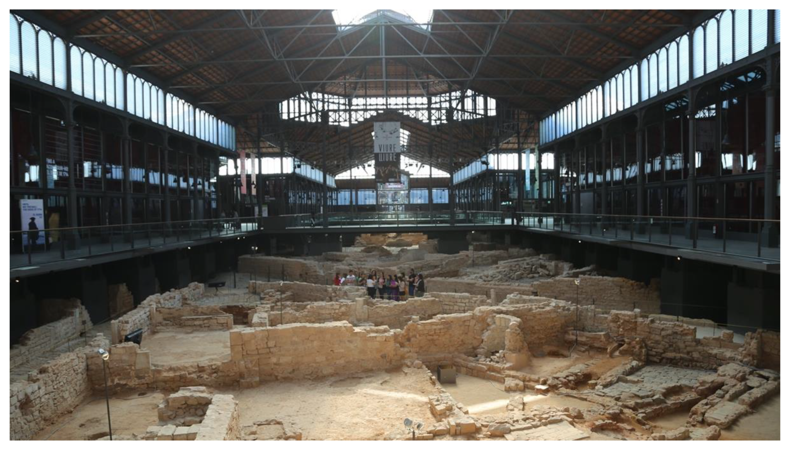
2.6. The Archaeological Site of “El Born” in Barcelona
Born of Barcelona is a unique archaeological site of about 8000 m
2 located in the old town of Barcelona [
64] in the basement of an old market of iron architecture. The Born neighborhood was fiercely bombed in 1713–1714 during the War of Spanish Succession [
65]. The sector was the scene of violent fighting that caused destruction. Later, just when the neighborhood was recovering from the disaster, in 1716, the Spanish military decided to demolish more than 800 houses to facilitate the construction of a powerful citadel that was to control the rebel city of Barcelona. The remains of the destroyed houses were buried under the glacis of the fortification [
66]. In 1869 the citadel was demolished and on what had been its grounds stood a large park, new buildings, and a spectacular market built with iron architecture, in the style of
Les Halles de Paris, the work of the architect Josep Fontseré. The market operated uninterruptedly until 1974 and was subsequently left unused. In 2001, a wide-ranging debate began on the future of the artifact, which was, in fact, a spectacular heritage item, a huge stand in the heart of the old town. There were many and diverse ideas to use the space of the Born, but as a previous step, the excavation of the subsoil proceeded. The archaeological intervention gave surprising results since the remains of the medieval and modern houses and streets appeared as they had remained after the demolition of 1716–1718. The combination of the spectacular ruins with the extraordinary space built by Fontseré generated a magical spectacle. After hard debates and demanding actions, the citizens of Barcelona demanded, and managed, that the ruins be preserved and that the Born became a cultural archaeological space. An extraordinary urban site of about 8000 m
2. [
67]. (
Figure 1,
Figure 2 and
Figure 3)
From 2013 DIDPATRI entered to work in a different museum and didactic projects in the Born. The third anniversary of the courageous resistance of Barcelona besieged by the Borbon troops was in 2014, and on the occasion of the anniversary several museum and didactic interventions were made, and the site was opened to schools [
68,
69].
For didactic purposes, it was decided to make a 3D survey of the archaeological site that approximated as it was in the early eighteenth century and contributed to the understanding of the mess of ruins of houses, streets, and channels. The survey should be based on scientific criteria and a realistic aesthetic that would help to inform, interpret, and understand and should be able to reapply to different face-to-face and virtual museum formats and, mainly, to didactic materials. The work was designed taking into account different criteria: starting from the archaeological plant, analyzing directly the structural, architectural evidence, consulting the historical documentation, and combining the 3D with 2D extensions.
The 3D survey was developed from the archaeological plant rigorously, without concessions to fantasy, and was limited to the exterior of buildings, courtyards, streets, and channels. Some of the archaeological evidence was especially taken into account: the textures of the building remains (stone walls, or masonry, or brick, as well as the batters that had survived), the presence of scrap yards, types of pavement in the streets, etc. One of the important problems was to define which houses should be covered with tile roofs, which were with flat tile roofs, very common in Barcelona. The houses with vertical storm pipes that were delivered to the street were covered with roofs and those that did not have them, with tile. It also took into account interior structural elements that had an impact on the exterior, such as the location of homes and chimneys. In addition, the pavements of the streets with paved areas and the areas of clay were faithfully replicated [
70].
The height of the houses was established taking into account the importance of the building, its typology, and the cases of similar constructions preserved in the same city. The Born area was an interclassist space in which medieval palaces, artisan homes, hostels, gambling houses, and commercial premises coexisted. The definition of heights and overtures was refined as much as possible thanks to the existing historical documentation. Barcelona has extraordinary notarial documentation, and the families that lived in the Born area were studied exhaustively by Alberto Garcia Espuche [
71]. The notarial inventories of post-mortem wills were a very important source of information since they not only gave an account of movable property and furniture but also established which plant or place of the building the various elements were located. Additionally, they often included location data of the house and its openings to the outside. These extraordinary documentary sources contributed to a credible image of the disappeared urban area. In turn, the iconographic documentation was also taken into account (a canvas by an anonymous author,
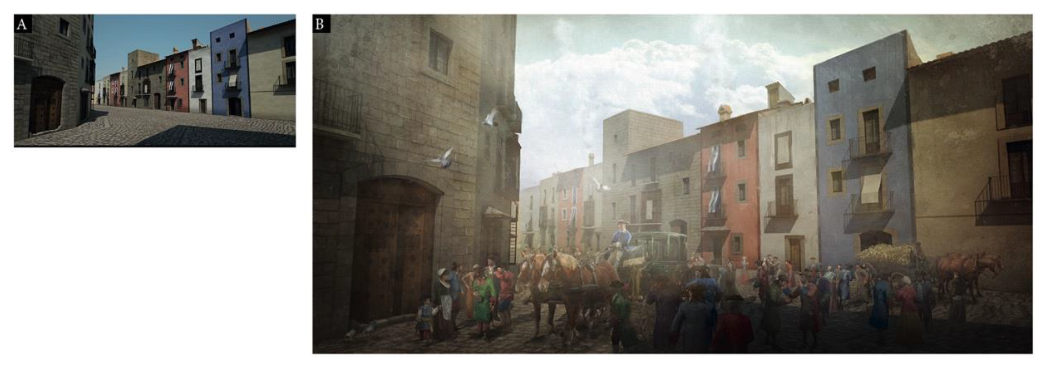
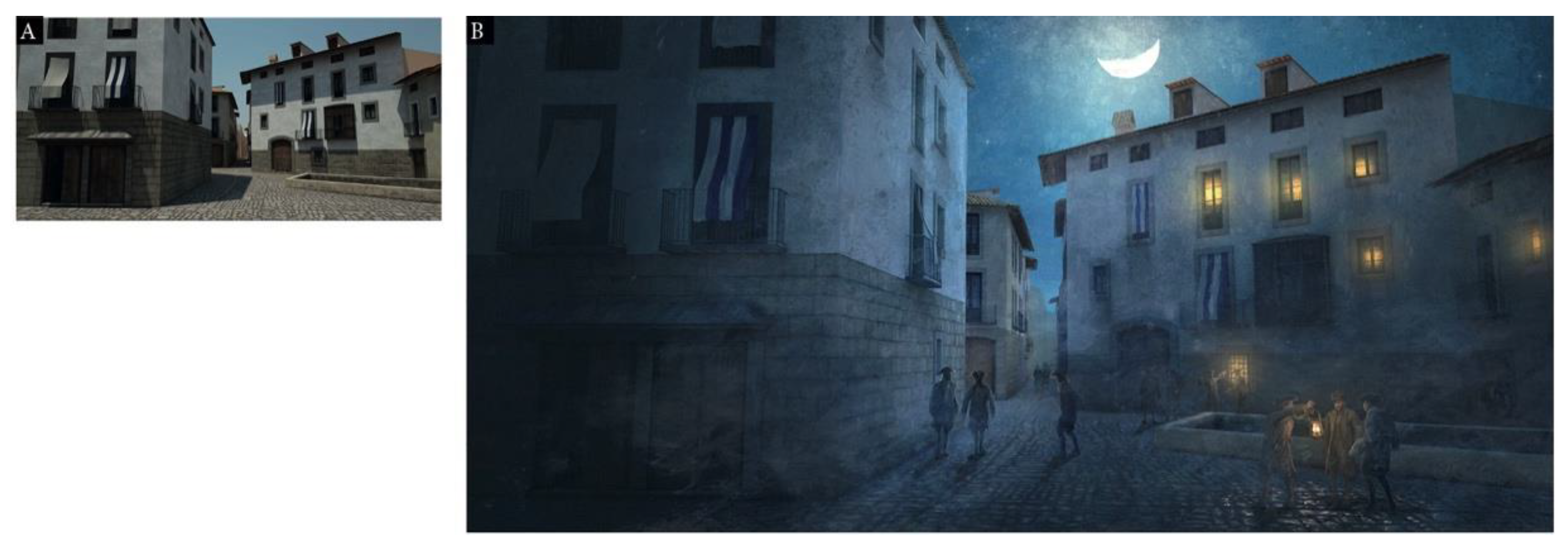
El Bornet, made at the end of the 18th century and showing an area that had once been spared the destruction) that maintained an aesthetic transferable to the entire Born district. The painting allowed us to see the heights of the artisans’ houses, the presence of balconies and windows, the lattices used in numerous windows, and the awnings in white and blue used to protect from the sun the doors of the facades, the balconies, and the windows.
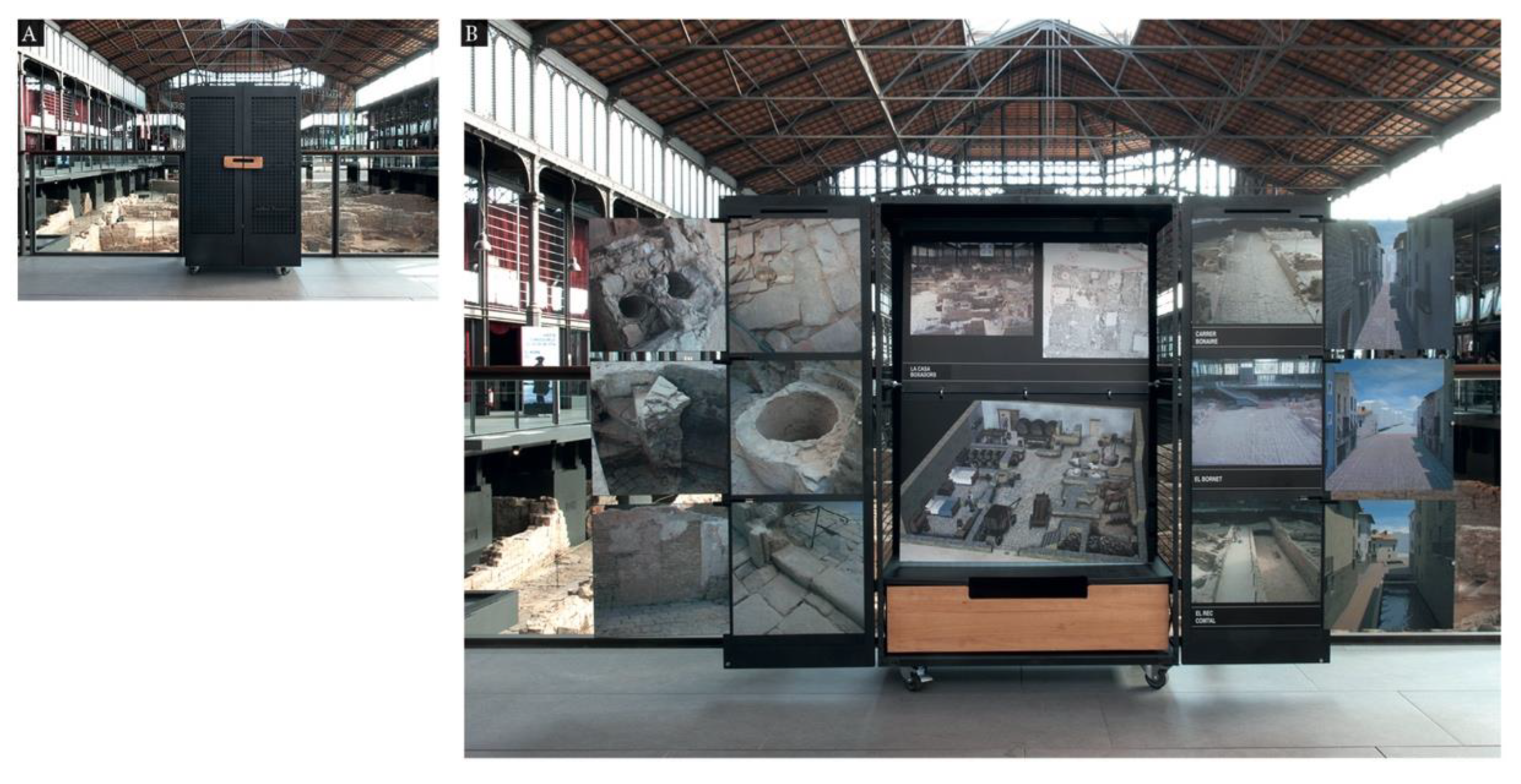
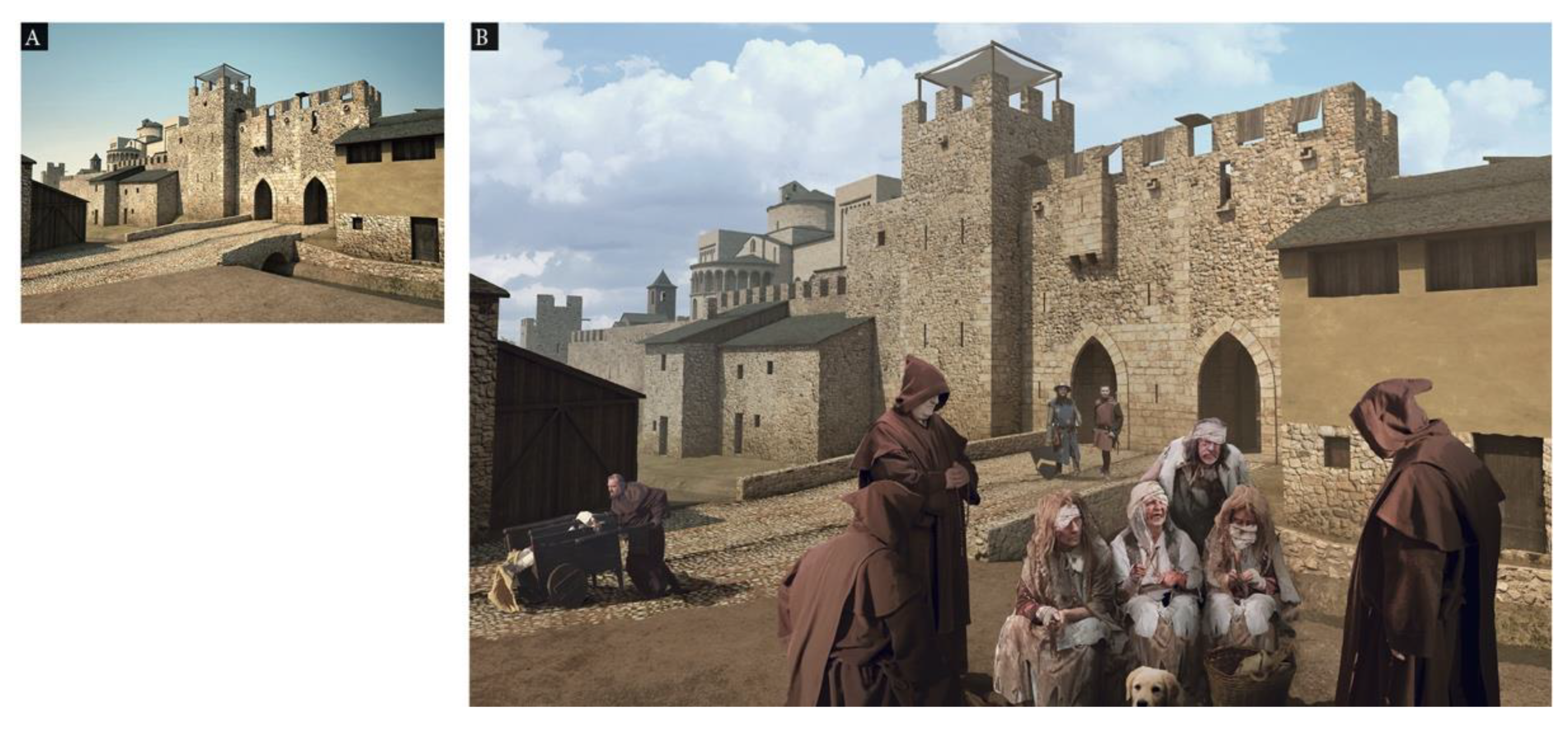
The urban 3D survey of the 8000 m2 of the Born was carried out by Josep Ramon Casals, under the direct direction of DIDPATRI researchers. Hyperrealistic images allowed animations in oblique aerial perspective and presentations from the most diverse points of view. These were used in the production of museography (audiovisual and virtual) and the edition of didactic materials. The material produced fulfilled its instructive function and also became an agent of sustainability since its possibilities of replication in panels, publications, videos, virtual environments, etc., were extraordinary.
It was considered from the outset that 3D should allow the incorporation of human, furniture, and environmental elements. The most interesting spaces were selected, and a 2D still image (from 3D) was obtained. The selected spaces were complemented by a matte painting by Guillem H. Pongiluppi, one of the illustrators integrated into the DIDPATRI research group.
The inclusion of people with realistic criteria presented difficulties since, in some places, the appearance of a crowd was necessary as they were noisy spaces. Computer-type human models were used. The result was uneven as they had an excessively rigid appearance. Finally, it was decided to use, preferably, images from re-enactment groups. On the other hand, the 2D images also reflected the atmosphere of a port city of the eighteenth century: smoke, dirt in the streets, shops, animals transiting, day views, and night views; in short, everything that characterized an active city. The set of hyperrealistic 3D, combined with the equally realistic matte painting 2D developments, provided a powerful didactic material that allowed understandable visions of the Born [
68]. Mobile didactic interpretation stations were carried out throughout the site, allowing, from different points of view, to compare the ruins with their reconstruction and hypothetical setting. (
Figure 4,
Figure 5,
Figure 6 and
Figure 7)
The evaluation of the material was made based on the qualitative evaluation of different types of experts (archaeologists, historians, professors, tourism technicians, heads of guides, etc.).
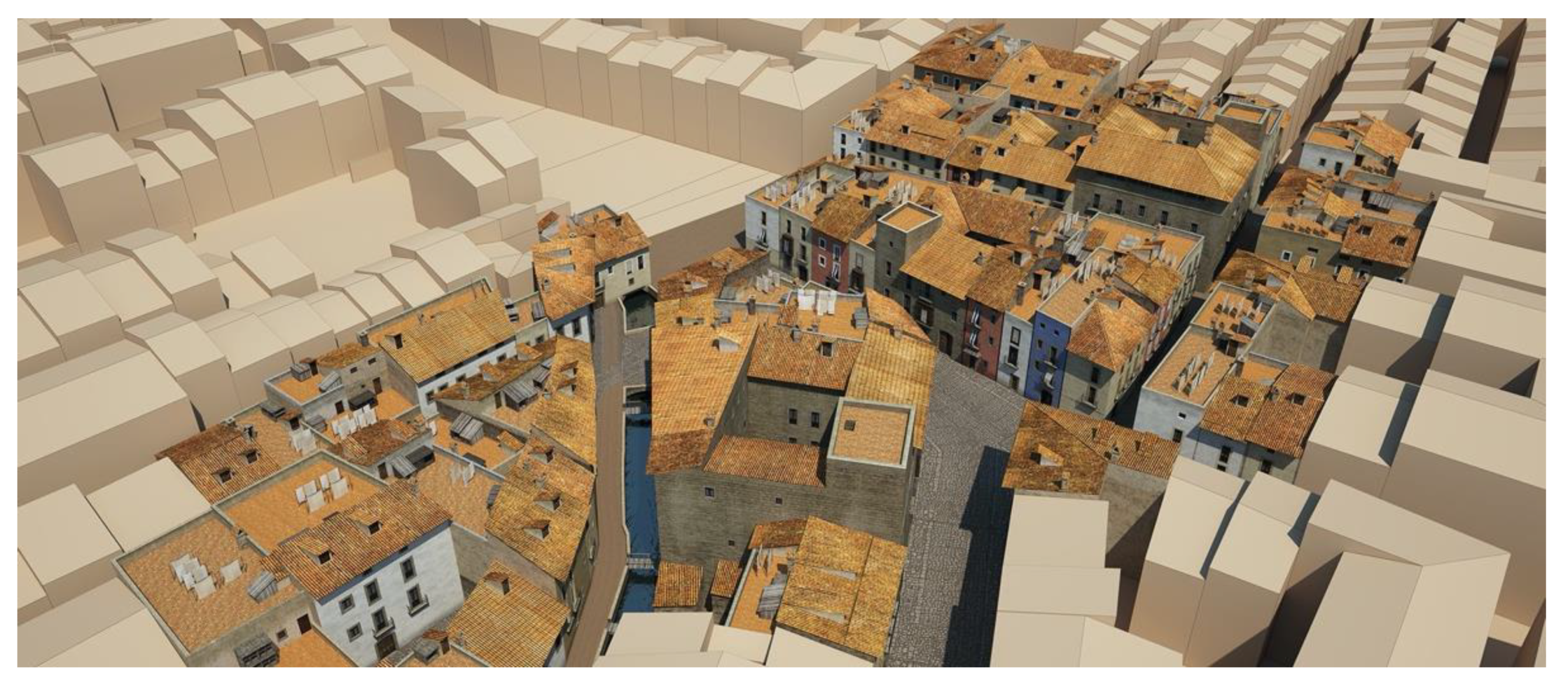
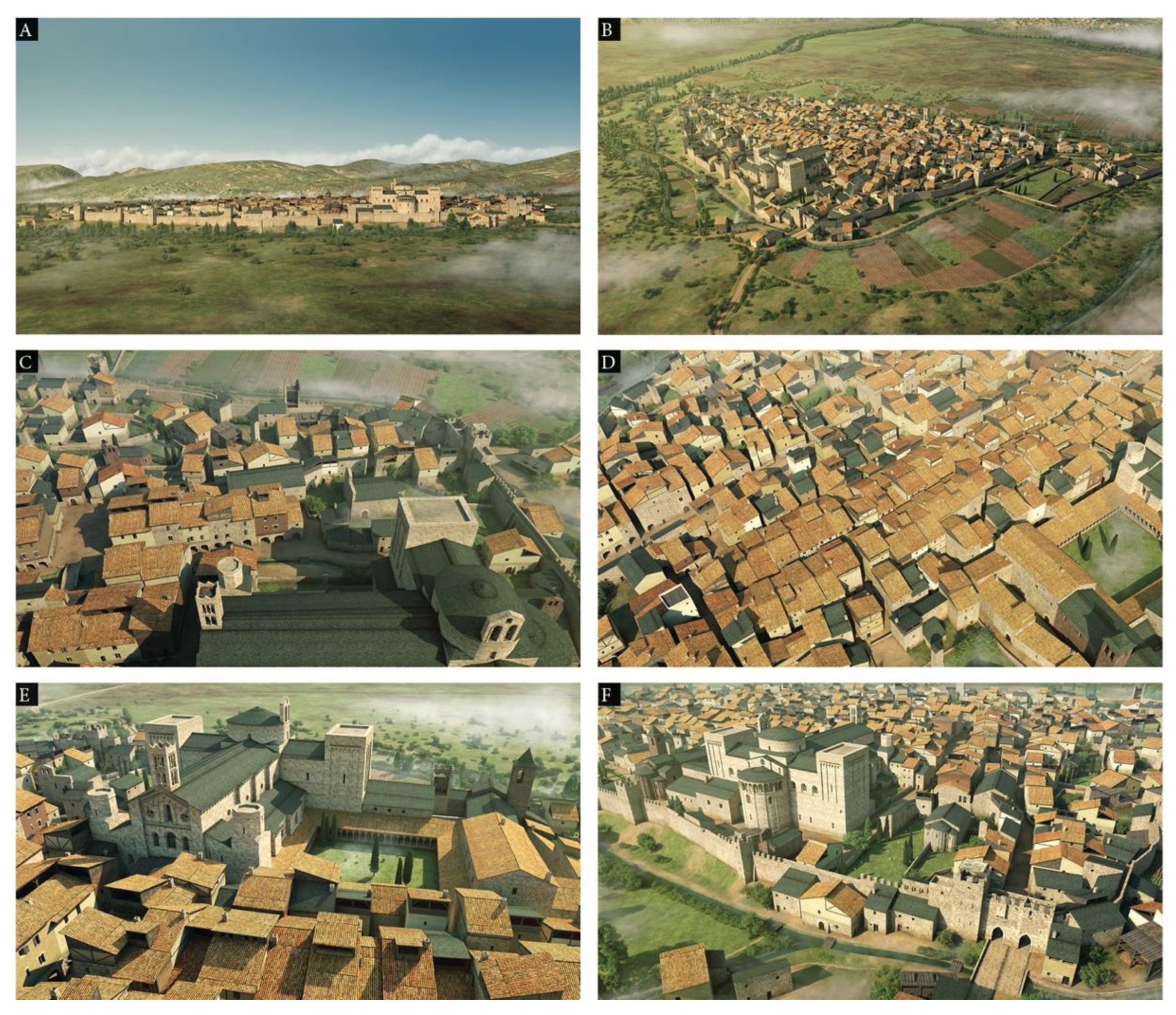
2.7. The Medieval City of la Seu d’Urgell
The second major experimental project on urban spaces, initiated in 2015 and developed in successive stages until 2020, focused on the recreation-reconstruction of the Pyrenean city of Seu d’Urgell (Lleida) during the 14th century. La Seu d’Urgell preserves, even today, a medieval old town that maintains certain integrity, and the virtual reconstruction should facilitate a greater understanding of the heritage elements vertebrated by the Romanesque cathedral of the city and integrated into a well-preserved urban grid [
72].
The big problem, which can be transposed to cases of assemblies with similar or superior dimensions, was the dimensions of the urban area to be represented, estimable in 1 km2. This is a measure that can be considered as a limit in paper format (DIN A3) or on-screen, retaining a sufficiently detailed and significant iconography of buildings, and with fully identifiable elements. For all this, the experience was interesting since we were in the limits, working a very singular urban set about its medieval heritage. In larger urban enclosures the overall view requires smaller scales and this implies the loss of precision concerning buildings and artifacts [
73]. In these cases, the approach to the global recreation of the city must be made necessarily by zones. The interest in working on the project was twofold: it reached the limit of a representable urban area, and, in turn, the experience could serve to present partial sectors of large urban areas [
74]. (
Figure 8)
In the case of la Seu d’Urgell, with much of the medieval urban fabric in operation, the intervention could be carried out with some certainty following the indications of local archaeologists and archivists. For the construction of the 3D, the plot plan was used; most houses responded to traditional medieval measures defined by the amplitude possibilities of the wooden beams. The types of urban houses in the Catalan Pyrenees had similar patterns, and hypotheses could be made with some certainty. On the other hand, the palaces, mills, convents, eras, walls, and singular buildings were sufficiently preserved or documented to venture their appearance in the fourteenth century. The main element of doubt was on the roofs since clay tiles and slate slabs were used in the houses. The issue was resolved with a random representation, giving roof tiles or slate, but with a higher proportion favorable to slate.
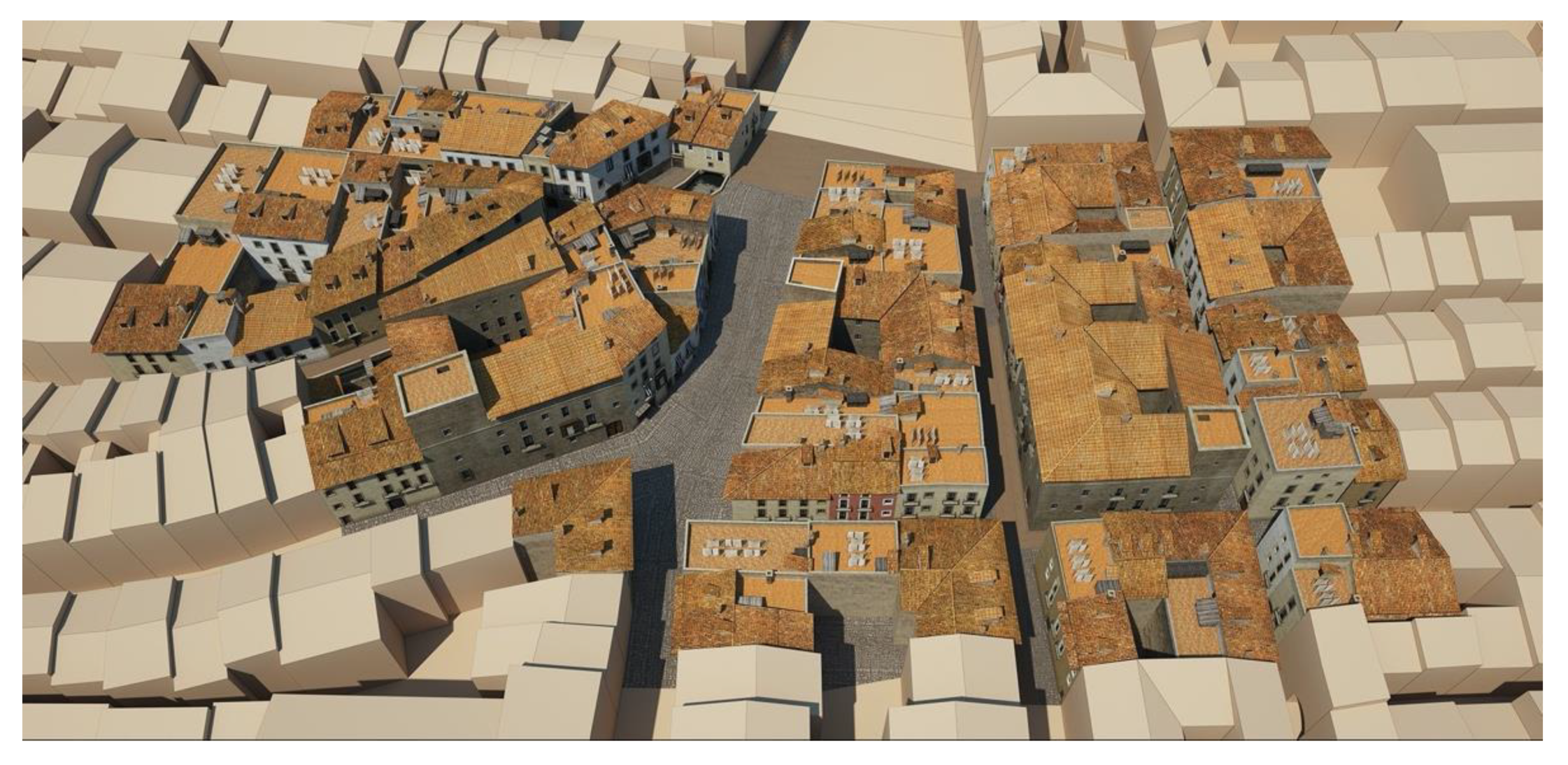
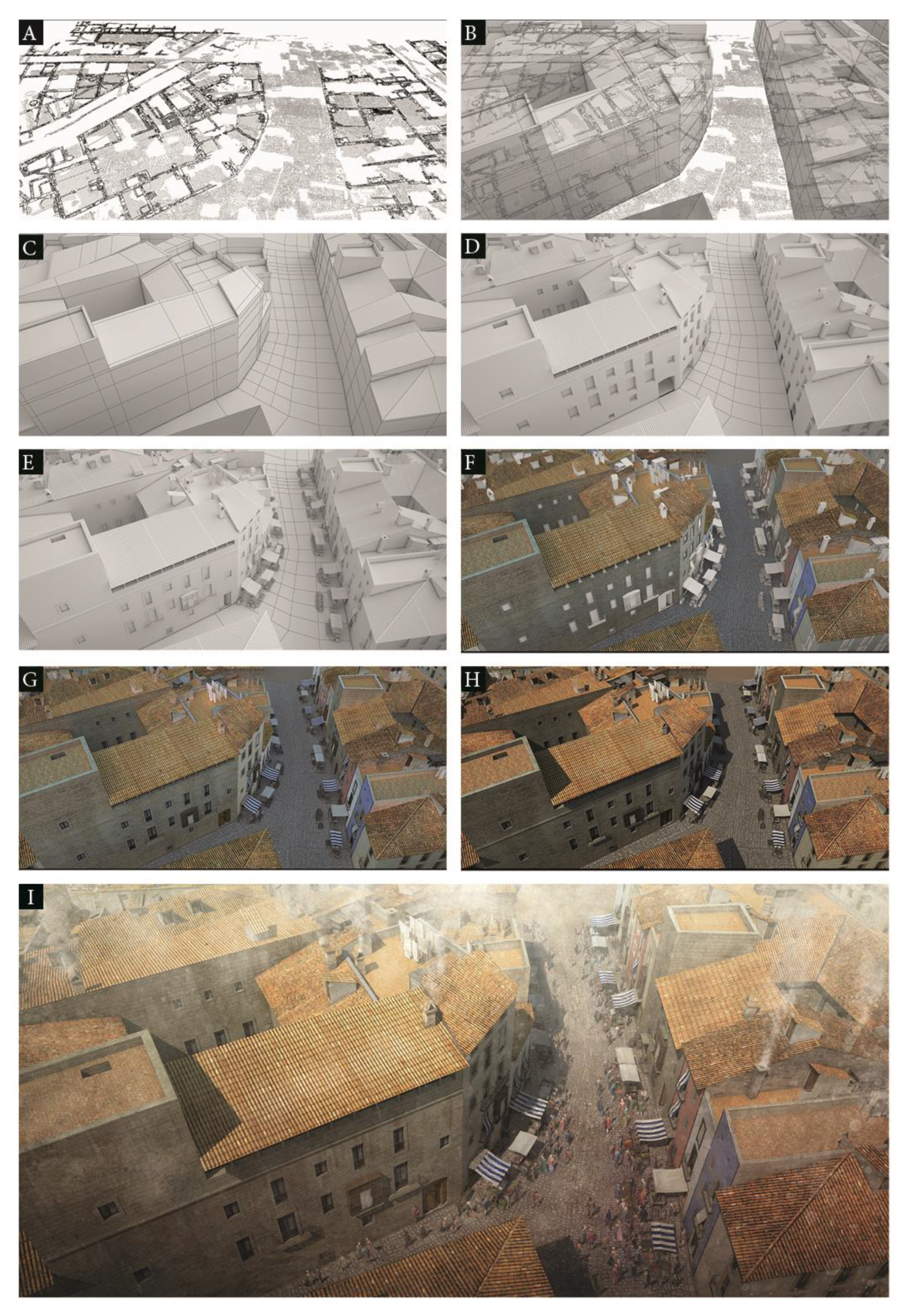
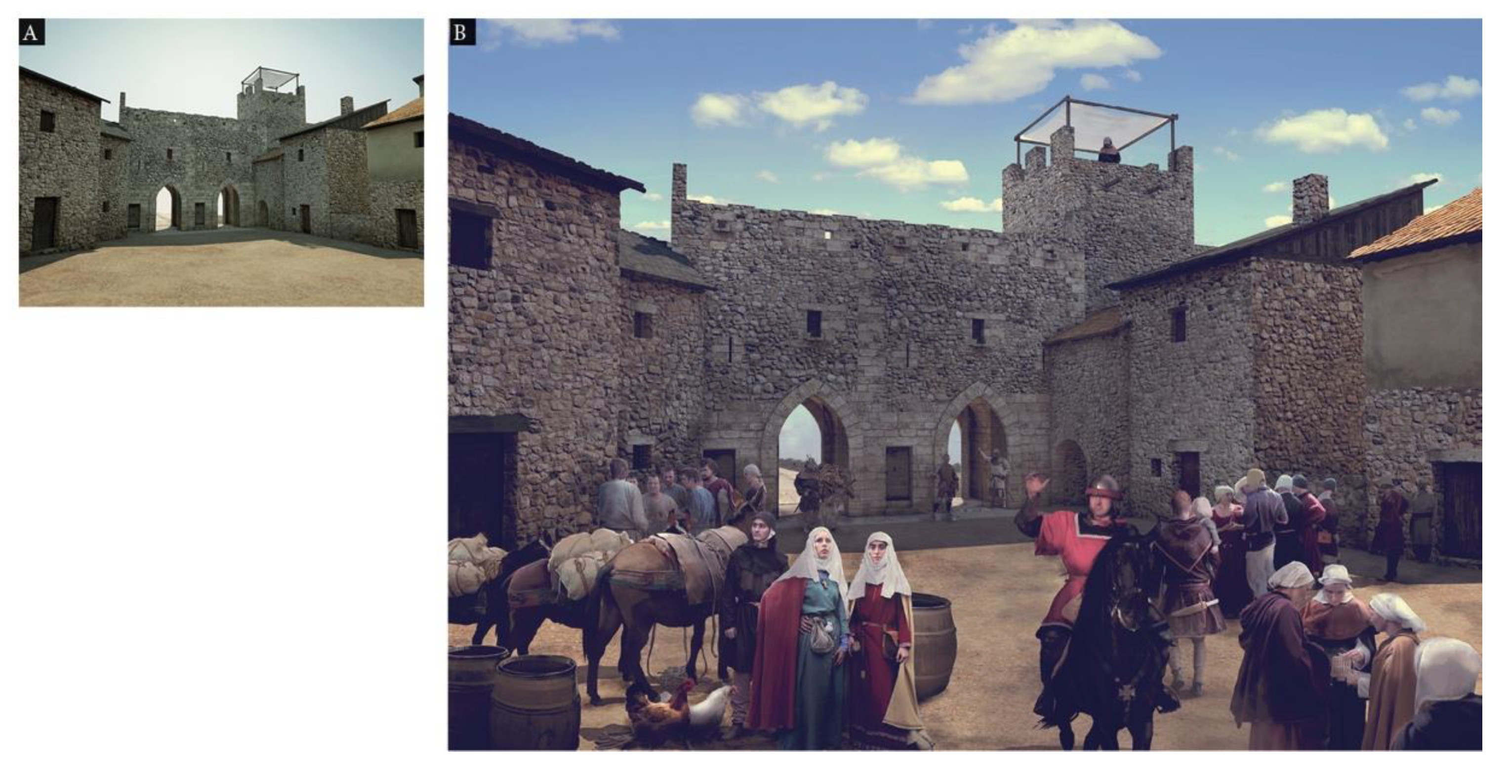
The incorporation of the city’s exterior landscape meant additional complexity. In the case of the recreation of the Born had not been a problem since the need to recreate the adjacent urban area was not considered and, on the other hand, more zenithal views were used. However, the fourteenth-century city was to show its suburbs and immediate landscape. These aspects could be resolved favorably. The 3D work was coordinated by DIDPATRI and executed by J.R. Casals. The 3D made it possible to visualize the appearance of the city from the most diverse points of view. On the other hand, the high resolution of the images allowed the precise vision of certain sectors, and this, as in the case of the Born, made it possible to approach a second phase using 2D.
From the 3D were selected the most significant spaces or of greater didactic interest (cathedral, the Jewish quarter, palaces, walls, etc.). The 2D images of these spaces were generated by selecting different points of view. Subsequently, the images were supplemented using the matte painting technique and using images from historical recreation activities as a priority. These illustrations, which involved the incorporation of environmental aspects, anthropic elements, and movable heritage, were made by F.X. Hernàndez. 2D replicated 3D images were also used to overlay kinetic elements from video recordings with the chroma key technique. (
Figure 9,
Figure 10 and
Figure 11)
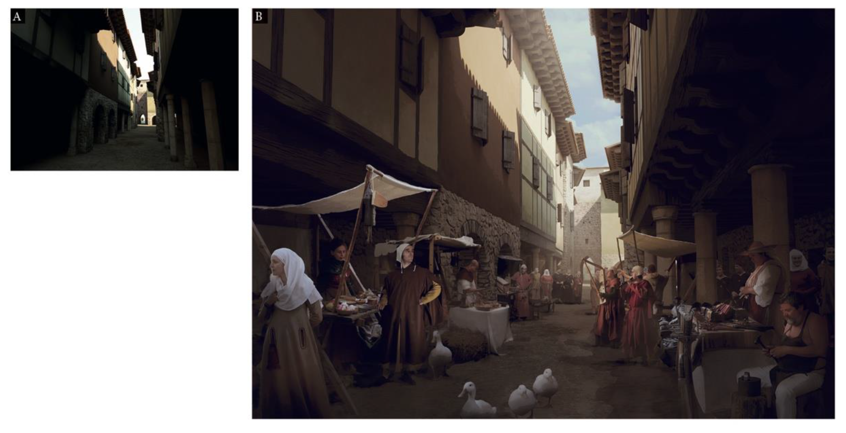
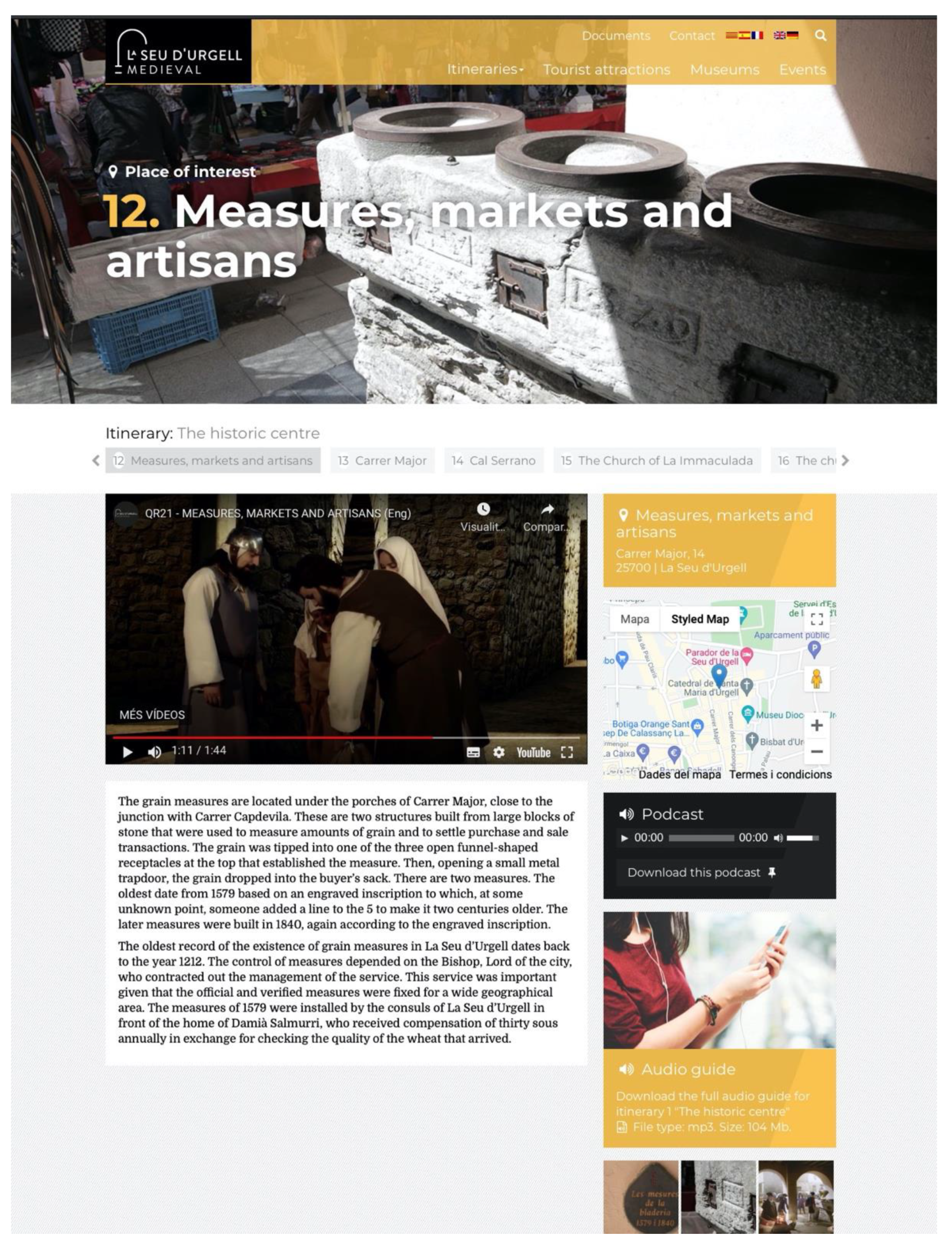
The 3D of the whole city became an authentic cultural, patrimonial, and tourist motor; it was used interchangeably in videos of promotion and explanation of the city, in diverse publications, didactic materials, and in fact, became the structural tool of the design of itineraries to know the city. A system of QR codes distributed in the most significant spaces allowed the reproduction of videos of short duration that, from 3D and 2D scenarios, and with the static or kinetic superposition of characters of the time, explained how the city and its inhabitants were during the medieval period. (
Figure 12 and
Figure 13).
3. Results
The different urban iconography projects in an instructive, civic and sustainable perspective have allowed generating interesting iconographic models in terms of knowledge and promotion of heritage. The projects developed from the urbanism of the Born site of Barcelona and the medieval urban complex of la Seu d’Urgell involved relevant transversal research.
Based on experience, it is possible to construct didactic iconographic models of urban spaces of the past, whatever their complexity, at a reasonable cost, through the use of software not excessively specialized. The realistic choice in iconography is the most understandable, and an understandable iconography, concerning urban spaces and their heritage, favors their valuation, preservation, and sustainability; factors that reinforce the civic dimension, education, and instruction, and constituting significant assets in a company.
The development of quality didactic iconographic models does not necessarily imply generating processes with a high economic cost. The constantly evolving market software and medium technical and professional expertise are sufficient to develop quality matte painting 3D models and illustrations. In any case, it is necessary to establish the criteria for action and the development of prototypes.
Digital iconographic models of urban spaces and heritage elements have a high capacity of replication from various media and with various functions: audiovisual, publications, museography, iconography, apps, virtual reality, augmented reality, etc. and have exceptional possibilities from so-called virtual museography. On the other hand, the digital database allows corrections to adapt to new knowledge, correct errors, or expand and modify information. This is a dynamic material capable of transformation and adaptation. Iconographic models can also be replicated to the most diverse functions: formal teaching—learning processes, cultural industries, cultural tourism, edutainment activities, etc.
The reasonable costs of urban didactic digital iconography, in terms of software, and the specialization in design, together with the possibilities of replication in different media and for different functions, its interest from the point of view of the public and its impact on greater knowledge and appreciation of the urban heritage. It gives didactic iconographic models an outstanding profile of sustainability since, in exchange for reasonable investments, very significant impact is achieved, to which must be added a long duration facilitated by the possibilities of change.
However, prototypes should be considered based on prescriptions supported by empirical experience. 3D prototypes/models developed in DIDPATRI research demonstrate that images of the past can be generated that go beyond simple architectural volumetry. Colors and textures can be included that make the spaces more understandable and must be considered from archaeological evidence, photogrammetry, laser scanner, historical documentation, or parallel cases [
74]. Movable and anthropic elements can also be included in 3D, but this implies more complex software, higher cost, and higher memory requirements when these elements must move in real-time. The experiences developed by DIDPATRI have focused and limited on the development of textured 3D urban spaces. Anthropic, furniture, or environmental elements have been added only in 2D developments and using either static or kinetic options. The optimal 2D developments, from the didactic point of view, are those that are posed with hyper-realistic criteria and show aspects of environments (smoke, waste, fauna, hours of the day,) as well as humans with congruent aspect depending on the space (artisans, combatants, vagrants, children), as well as flora and fauna (plants, gardens, and pets or not: dogs, cats, rats, seagulls, etc.).
The iconographic models generated could easily be evaluated qualitatively from questionnaires and interviews with heritage, education, tourism professionals, and policy and governance decision-makers. In the case of "Born" 24 technicians in heritage and tourism, 24 Primary and Secondary education teachers and 20 political leaders and governance technicians were consulted. In the case of La Seu d’Urgell, the consultations involved 20 experts in Heritage and Tourism, 20 teachers of Primary and Secondary education, and 12 political leaders and governance technicians. In a complementary way, historians and archaeologists were also consulted.
Perceptions of this type of material, and its possibilities, have been well considered. On the other hand, the materials have been well received by the market (cultural tourism, museography, cultural industries), which constitutes an explicit evaluation. Iconography has been successfully applied to very different products, on different media, and for different functions.
The instructive dimension of iconographic didactic models demands, moreover, rigor, graphic transposition of the elements generated by disciplinary research, congruence with historical and archaeological knowledge, prudence in the use of parallelisms, and the selection of the elements needed to make one space comprehensible and its functions.
4. Discussion
The generation of didactic images, sufficiently holistic, on urban spaces of another time and through time, allow a greater understanding of the city, its heritage, and its historical dynamics. This dynamic has an impact on the acquisition of greater opinion by citizens and contributes to a better, more balanced, and sustainable city [
14]. The knowledge of the past is a functional asset in that it allows the most diverse reapplications in daily life, optimizing the capacity of interpretation and decision of people regarding their living environments. However, these assertions could be considered unsubstantiated. It could be argued that, ultimately, the sustainability of a city, about the geographical and environmental environment, does not necessarily depend on the state of conservation of the heritage, nor the knowledge of the past. However, it is also true that our societies are historical in that they accumulate knowledge from knowledge and cosmovision’s generated in the past. History conditions the present and shapes diverse identities from the most diverse aspects of everyday life (beliefs, fears, customs, habits of health, fun, gastronomy, attitude to work, etc) [
75]. In this sense, analyzing and opting rationally in the present requires knowing the determinants of the past. On the other hand, heritage is made up of elements from the past that are part of our present and to which we give value. The perception and consideration of heritage are changing and depend on the axiological criteria and values of a given society at a given time. To put it another way, the past, history, and heritage, implicitly or explicitly, consciously or unconsciously, are part of our daily reality, and its consideration contributes to maintaining the fragile balance that human societies invariably present in a context of civilization.
However for a society to be aware of the values and assets (ideology and economic, empirical, and axiological) that heritage implies as a factor of sustainability, it is necessary to make this heritage known. In the case of cities, the spearhead of civilization, the knowledge of heritage is understood as heritage and requires an understanding of the urban environment, and its limits concerning the geographical space and its demographic structure. Explaining the city to citizens optimizes the action of citizens in the city, and prepares them to live in it. The debate focuses, in this sense, on how to better explain cities and their heritage and how emerging technologies contribute to this teaching-learning process [
76].
It is precisely in this context of general interest that the didactic iconographic models that show the city: its sectors, its heritage, or its evolutionary processes, simplify the abstraction prerequisites necessary to understand urban space, and this makes them instruments of interest. Iconographic models allow and accelerate the understanding of the city to people who may have limited or disparate preconceptions about it. In this sense, the school environment, with an important critical mass of people in the process of formation, becomes a clear target of actions and materials of this type. Additionally, for broad sectors of the population and for people who, coming from the most diverse places, have an interest or need to know a certain city.
The development of urban iconographic models on the other hand, and based mainly on empirical experience in the development and experimentation of prototypes, indicates that certain techniques (rather than technologies) and protocols of action favor the understanding.
5. Conclusions
The didactic iconography design of historical urban spaces requires considering various variables that, as they combine, can give rise to very different solutions [
74]. First, the scale and point of view must be considered. For broad views (i.e., neighborhoods, sectors of the city), oblique aerial points of view appear as more useful in that they surpass the abstraction of the top perpendicular views (very interesting on the other hand) and the reduction to contours that cartography implies. A building or space viewed from an oblique high point of view is understandable, and, in its representation, it is easy to identify its main features.
Therefore, the oblique air point of view is undoubtedly one of the functional options to approximate the description of a certain historical urban space. As far as scales are concerned, of course, significant scales should be used to identify buildings and urban spaces in some detail. This assessment of the oblique viewpoints is not, in any case, exclusive and unique since the use of ground-level viewpoints is very useful for contemplating and recreating the evolution of certain urban landscapes and allows a very direct comparison between present and past [
77,
78]. In this sense, we must bear in mind that oblique aerial visions and ground-level visions are complementary.
As far as the characteristics of the image are concerned, it should be borne in mind that iconographic representations need not necessarily be regarded as an initiative of artistic creation, although they may be. In this sense, it is necessary to prioritize the realistic or hyperrealistic options, since they are the ones that most accurately reflect a given reality at a given moment. This also means that, as far as possible, textures and colors should be used following the spaces represented at a given historical moment.
In this line of argument, it should be considered that urban space can only be conceived with functions: living and living space, productive space, leisure space, management space, transportation, etc. This means that a historical space cannot be fully understood without considering the functional and environmental elements (smoke, waste, hygiene, disposal, and scrapping of waste, energy, lighting, means of transport, etc.). The representation should also reflect the activities of production, management, and human relations in general (workshops, markets, public activities, etc.) [
79]. This implies that the human factor (which is ultimately the object and subject of the city) must be present. These elements of “environment” superimposed on the urban recreation of the spaces can be used mainly at nearby scales (large scale). It is obvious that, on distant scales, showing neighborhoods or global spaces of a city, the representation of human figures will lose significance.
It should also be noted that the iconographic representation of urban spaces also depends, on the technological resources existing at a given time and the techniques that enable them. The authors of the Renaissance, from drawings and prints, already generated models of cities and historical spaces, which from a conceptual point of view are similar to current representations. However, it is obvious that the new technologies CGI (Computed-Generated Imagery), in continuous evolution, facilitate the possibility of new iconographies [
80]. The emergence of 3D was very important, and the generation of new philosophies of iconographic representation such as matte painting and Conceptual Art has also involved new horizons.
The achievements achieved by large projects linked to computer games (with their complex engines) and movies; and about spatial representations and human life of the past are very relevant. Conversely, the resources invested in these star products imply very high production costs. However, it is possible, from the basic market software, to generate didactic iconography of the past at a reasonable and sustainable cost. This implies that if the techniques and technological resources present at each moment are correctly selected, comprehensible past iconographies of quality and reasonable costs can be generated. These digital iconographies can be transformed to meet specific demands and can be adapted to diverse media and functions (teaching, instruction, tourism, cultural industries, museography, etc.). In this sense they are sustainable from an economic point of view if costs and results are compared, and they also contribute to the sustainability of urban environments by influencing the formation of quality citizenship, which knows and affects the future of the city and support cultural industries and cultural tourism.


