Article

Evolution of Urban Construction Land Structure Based on Information Entropy and Shift-Share Model: An Empirical Study on Beijing-Tianjin-Hebei Urban Agglomeration in China

1
School of Public Administration and Policy, Renmin University of China, Beijing 100872, China
2
College of Agriculture, Yangzhou University, Yangzhou 225009, China
*
Author to whom correspondence should be addressed.
Sustainability 2022, 14(3), 1244; https://0-doi-org.brum.beds.ac.uk/10.3390/su14031244
Submission received: 25 December 2021 / Revised: 17 January 2022 / Accepted: 20 January 2022 / Published: 22 January 2022

Abstract

:
Urban agglomerations are important carriers of the current world economic development and economic center of gravity shift, while urban construction land structure reflects and influences the functions and development directions of urban agglomerations and cities within them. It is significant to study the characteristics of urban construction land structure in urban agglomerations. Based on information entropy model and shift-share model, this study discusses and analyzes the evolution characteristics and spatial allocation differences of urban construction land structure in Beijing-Tianjin-Hebei urban agglomeration, and simulates the spatial allocation differences with the help of GIS technology. The empirical research results show that from, 2006 to 2017, the overall structure of urban construction land in Beijing-Tianjin-Hebei urban agglomeration changes alternately between “orderly” and “disorderly”, and finally the overall development was slightly disordered. Furthermore, there are significant differences in the competitiveness of different types of land in different cities. Among them, green land, public facilities land, and road traffic land show obvious replenishment effect, which are mainly distributed in Handan-Zhangjiakou northwestern Hebei, Tianjin-Cangzhou in the eastern coast, Baoding-Xingtai in central and southern Hebei, while industrial land and storage land, which are mainly distributed in Beijing-Tangshan-Langfang around the capital and Shijiazhuang-Handan-Hengshui in central and southern Hebei, show obvious crowding-out effect. In addition, the temporal changes and spatial allocation differences of urban construction land structure are influenced by many factors, such as economic development, industrial structure, population size, etc. Therefore, it is suggested that the coordinated development of urban agglomerations should adhere to the principle of “differentiated development before coordinated development, local coordinated development before overall coordinated development”.

1. Introduction

In the context of globalization, countries around the world are becoming more and more closely connected. For example, the rapid and long-lasting spread of the coronavirus disease 2019 (COVID-19) around the world has had a huge negative impact on the economies of various countries around the world, making the world economic landscape increasingly complex. Therefore, developing the economy and enhancing international influence are the most important development goals for each country at present and even for a long time to come. In fact, urban agglomerations have become important carriers for countries to participate in international competition and shift the center of gravity of the world economy. In China, they are also the new growth pole of economic development and the main “battlefield” of “One Belt, One Road” construction [1,2]. Meanwhile, urban construction land is an essential carrier of cities and urban agglomerations, and its internal structural changes are a reflection of the “game equilibrium” between the internal elements of the urban land use system and the external environment, which directly affects the overall functions of cities and urban agglomerations [3]. Therefore, it is of great significance to study the change law of urban construction land structure to promote the coordinated and high-quality development of urban agglomerations, and thus enhance their comprehensive competitiveness.
Beijing-Tianjin-Hebei urban agglomeration is not only the political and cultural center of China, but also the third pole of China’s economic growth [4]. In the process of development, there are still many problems, such as overpopulation, unreasonable economic structure, uncoordinated regional development, serious pollution, and so on, which have seriously affected the level and quality of economic development of urban agglomerations [5,6]. Based on the above, this paper takes 13 cities in Beijing-Tianjin-Hebei urban agglomeration as examples, and comprehensively uses information entropy and shift-share analysis model to discuss and analyze the time series characteristics of urban construction land structure and the differences of its spatial allocation, in order to provide reference for understanding the change laws of urban construction land structure of Beijing-Tianjin-Hebei urban agglomeration and promoting the coordinated development and high-quality development of Beijing-Tianjin-Hebei urban agglomeration.
Based on previous relevant studies, this paper focuses on the following three issues: (1) what are the characteristics of the changing structure of urban construction land in the Beijing-Tianjin-Hebei urban agglomerations; (2) what are the characteristics of the differences in the spatial allocation of urban construction land structure in the Beijing-Tianjin-Hebei urban agglomeration; and (3) how to promote the coordinated and sustainable development of urban agglomerations. On this basis, we assume that the evolution law of urban construction land structure in the Beijing-Tianjin-Hebei urban agglomeration is consistent with the findings of other related studies, i.e., the larger the city size and the higher its economic and social development level, the more balanced and disorderly the overall urban construction land structure. In addition, the novelty of this paper is mainly in combining the traditional information entropy model with the offset-share model, and also to simulate the spatial configuration differences with the help of GIS technology, so that readers can more intuitively figure out the spatial and temporal evolution characteristics of the urban construction land structure in the Beijing-Tianjin-Hebei urban agglomeration. Finally, the research objectives and contributions of this paper are mainly to enrich the practical applications of the shift-share model in the field of land use and to further deepen the research related to the differences in the spatial allocation of urban construction land structure, so as to propose countermeasures and suggestions for the coordinated and sustainable development of the Beijing-Tianjin-Hebei urban agglomeration.

2. Literature Review

2.1. Analysis of Construction Land Structure Based on the Information Entropy Model

Some scholars used the information entropy model to quantitatively study the structural characteristics of construction land in different regional cities at home and abroad, different types of cities, different functional cities, and cities under different spatial scales, and then discussed and analyzed the corresponding results and influencing factors. In terms of different national cities, Gao et al. analyzed the dynamic changes of urban construction land structure in the Yangtze River Delta region of China with the help of the information entropy model and other methods, while He et al. discussed the land use structure (including construction land structure) in the Tampa Bay watershed of Florida, USA based on the information entropy model and other methods [7,8]. In terms of different types of cities, Nie et al. used the information entropy model to evaluate and analyze the structural characteristics of construction land and its variability in 238 cities classified into different types in China [9]. In terms of different functional cities, Lu et al. classified 261 cities in China according to their different functions, and then discussed and analyzed the structural characteristics of construction land in cities with different functions using the information entropy model [10]. In terms of cities at different spatial scales, Xu et al. evaluated and analyzed the construction land structure of the Liao Zhongnan urban agglomeration based on the information entropy model and other methods, while Zhang et al. discussed and analyzed the dynamic changes of urban construction land structure characteristics in Nanjing using the information entropy model and other methods [11,12].
In fact, although the information entropy model can describe the time-series change characteristics of urban construction land structure, it is only in terms of the general situation of construction land, and it does not reflect the evolution law of each category within the system; in particular, it does not reflect the difference of spatial allocation. Consequently, other scholars have tried many other methods to solve these two problems.

2.2. Analysis of Structural Characteristics of Various Types of Urban Construction Land

In order to explore the structural characteristics of each type of urban construction land, Guo et al. used data envelopment analysis [13], Lorentz curve [14], Gini coefficient [15], and other analysis methods [16,17,18] to simulate and analyze the characteristics and evolution patterns of each type of urban construction land structure in Haixi urban agglomeration, Guangdong-Hong Kong-Macao Greater Bay Area urban agglomeration, and various provinces in China, respectively. Through these methods, scholars have further explored the degree of balance in the allocation of each specific category of construction land based on the analysis of the overall structural characteristics of urban construction land. However, although data envelopment analysis, Lorenz curve, Gini coefficient, and other methods can further help us figure out the degree of equilibrium of each type of construction land, they still cannot reflect the speed of change of each type of urban construction land relative to the overall regional urban construction land in the process of economic and social development, especially the gap in spatial allocation. Therefore, other models and methods are needed for further in-depth study.

2.3. Analysis of Spatial Allocation Differences of Urban Construction Land Structure Based on the Shift-Share Model

A small number of scholars filled the research on the difference of spatial allocation of urban construction land structure by introducing the shift-share model [19,20]. Among them, Kuang et al. used the shift-share model to study and analyze the urban construction land structure of Wuhan urban agglomeration, and deeply explored the structural competition degree and regional competition degree of various types of urban construction land in Wuhan urban agglomeration during 2001–2011, and also simulated and evaluated the spatial allocation differences [3]. Furthermore, other scholars have also discussed and analyzed the structural competition degree and regional competition degree of urban construction land structures and their spatial allocation differences in the Liaozhongnan urban agglomeration [11], the Central Yunnan urban agglomeration [13,21], and the Shandong Peninsula urban agglomeration [22] by means of the offset-share model. There are still relatively few studies discussing the differences in the spatial allocation of urban construction land structure with the help of shift-share analysis, especially those taking urban agglomerations as research objects. Therefore, there is a need to further enrich the case studies of the shift-share model in the field of land use, and thus improve the inner evolution laws of the land use structure, especially the structural characteristics of urban construction land.

3. Materials and Methods

3.1. Materials

3.1.1. Study Area

Beijing-Tianjin-Hebei urban agglomeration is located at 113°27′~119°50′ E, 36°05′~42°40′ N (Figure 1), and the area of the region is about 216,000 square kilometers, accounting for 2.3% of the total land area of China. The landform in the region is complex and diverse, of which the mountainous area and the plain area account for 48.2% and 43.8% of the total area respectively, and the region is in a typical warm temperate continental monsoon climate [4,23]. In 2019, the GDP of Beijing-Tianjin-Hebei urban agglomeration was 8458 billion yuan (CNY), accounting for about 8.45% of the national GDP. The resident population is 113 million, accounting for 8.08% of the total population of China, and the urbanization rate is 66.7%.

3.1.2. Data Sources

The data of urban construction land in Beijing, Tianjin, and Hebei from 2006 to 2017 are all from China Urban Construction Statistical Yearbook. The standard used in the yearbook in 2011 and earlier was the Standard for Urban Land Classification and Planning of Construction Land (GB137-90); however, the standard used in 2012 and after was the Standard for Urban Land Classification and Planning of Construction Land (GB50137-2011). In order to unify the caliber, this paper draws on the previous research results and simplifies the urban construction land structure in Beijing, Tianjin, and Hebei into residential land, public facilities land, industrial land, storage land, road traffic land, municipal utilities land, and green land [11,24]. At the same time, for the missing data of individual years and individual types of land in Beijing and Tangshan, this paper interpolates the predicted values based on the law of changes in the scale of construction land, the average value of land in the previous and subsequent years, or the average annual growth rate of land from recent years. In addition, the economic and population data in this paper are obtained from China Statistical Yearbook, China Regional Economic Statistical Yearbook, Beijing Statistical Yearbook, Tianjin Statistical Yearbook, and Hebei Economic Yearbook, etc.

3.2. Methods

3.2.1. Information Entropy Model

Information entropy was originally proposed by the American mathematician Claude Elwood Shannon in 1948 with reference to the concept of thermodynamics [25], to describe the degree of missing information in a system or the uncertainty of a random event, which can be measured by the probability of occurrence of the information or random event, and the higher the probability, the smaller the uncertainty of the information or random event, and vice versa the larger the uncertainty. In a system, there is usually not only one kind of information or random event with uncertainty. If there are multiple independent information or random events in a system, then the average uncertainty of multiple information or random events can be used as the information entropy of the system as a whole. Therefore, the greater the uncertainty of the variables in the system, the greater the entropy, the higher the overall randomness of the system, the higher the information entropy of the system as a whole, and the more information is needed to understand the system itself, and vice versa. When it is used in the analysis of urban construction land structure, it can reflect the internal order and diversity of urban construction land system as a whole [9,11,19]. The expression is as follows:
H = l n P i
P i = S i / i = 1 n S i
where H is the information entropy and the unit is bit (Nat); its size reflects the types of urban construction land and the uniformity of various land areas. When each type of land area is equal, the entropy value is the highest, Hmax = lnn. Pi is the ratio of the area of each type of land, obviously P1 + P2 + P3 + ⋯ + Pi = 1. From the model, it can be seen that the more types of construction land, the greater the entropy value and the more disordered the system is.
To further reflect the gap between the real situation and the ideal state, based on the above formula, the equilibrium degree (J) and the dominance degree (I) are obtained:
J = H/Hmax
I = 1 − J
where the equilibrium degree J [ 0 , 1 ] reflects the difference between various types of urban construction land area. The higher the value, the smaller the difference in the area of various types of construction land, the higher the homogeneity and the more balanced the land use. The dominance degree I [ 0 , 1 ] reflects the dominant degree of one or several types of land. The higher the value, the more concentrated the types of construction land are.

3.2.2. Shift-Share Model

The shift-share model was first proposed by Creamer [26] and Knudsen [27], then summarized and gradually improved by Dunn [28] and others [29]. It is a more ideal tool for quantitative analysis of structural and regional economies and mainly used in regional economic development, market structure evolution, industrial structure optimization, and other fields. The shift-share model considers the economic development of the study area as a dynamic process, and its general idea is to take the economic development of the study area as a reference for the economic development of its sub-regions. In the analysis process, the development of each sub-region is compared with the development of the study area, and then the total economic volume of the sub-study area is decomposed into “the national share component” influenced by the overall economic development of the study area, “the industrial mix component” influenced by the economic structure, and “the regional shift component” influenced by the competitive relationship between the sub-study areas, so as to elucidate the reasons for the economic development or decline of the sub-study areas. In the analysis of urban construction land structure, the basic idea of the shift-share model is to compare the development of urban construction land in the reference region (usually the administrative region above the study area, etc.), and decompose the urban construction land in the study area (usually a sub-region of the reference region) into the national share component (NSij), the industrial mix component (IMij), and the regional shift component (RSij), which are used to respectively describe the “rationing effect” of urban construction land in the reference region on urban construction land in each study area, whether a certain type of urban construction land structure is at a growth advantage, and the competitive advantage of a certain type of urban construction land in the sub-region over other sub-regions. In addition, since the shift component plays a moderating role on the share volume, the ratio of the sum of the industrial mix component and the regional shift component to the share volume is usually used as the shift share ratio (SSRij) to reflect the moderating strength of the shift component on the share volume [11,20,30,31]. The equations for each variable are as follows:
N S i j = S i j 0   ×   ( S t S 0 ) / S 0
I M i j = S i j 0   ×   ( S j t S j 0 ) / S j 0   N S i j
R S i j = ( S i j t S i j 0 )   S i j 0   ×   ( S j t S j 0 ) / S j 0
SSRij = (IMij + RSij)/NSij
where S i j 0   denotes the area of a certain type of urban construction land in a certain city at the beginning time, and S i j t denotes the area of a certain type of urban construction land in a certain city at time t. S j 0 denotes the area of a certain type of construction land in the reference region at the beginning time, and S j t is the area of a certain type of construction land in the reference region at time t. S 0 denotes the total area in the reference region at the beginning time, and S t denotes the total area in the reference region at time t.

4. Results

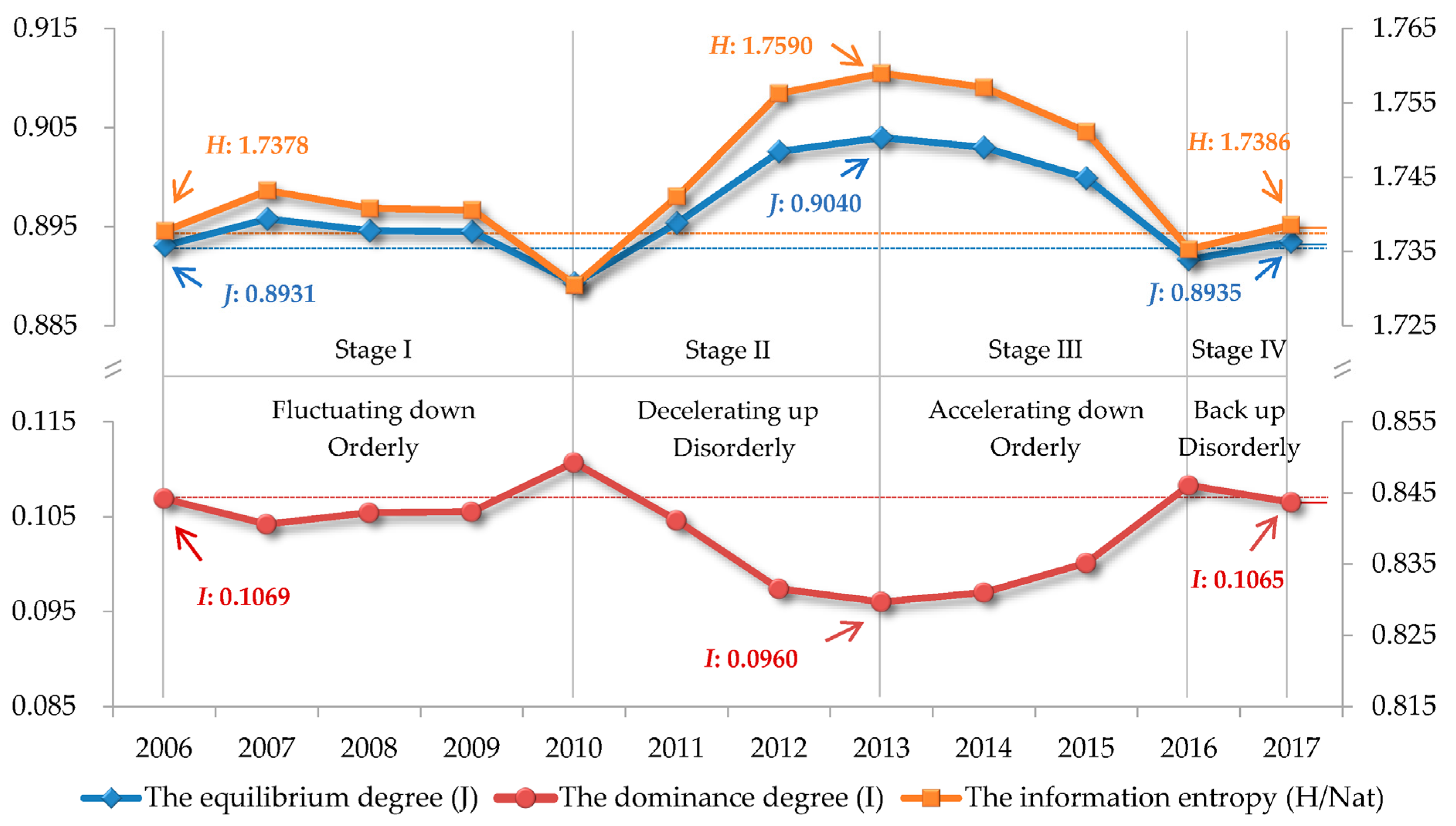
4.1. Characteristics of the Temporal Evolution of the Overall Structure of Urban Construction Land

Based on the statistics of the current situation of urban construction land structure in Beijing-Tianjin-Hebei urban agglomeration from 2006 to 2017 (Appendix A: Table A1), this paper evaluates the information entropy, equilibrium, and dominance of urban construction land structure, and then discusses the evolution law of urban construction land structure.
Generally speaking, from 2006 to 2017, the information entropy and the equilibrium degree of the urban construction land structure in Beijing-Tianjin-Hebei urban agglomeration show a change process of “fluctuating down-decelerating up-accelerating down-slowly rising back up“, while the dominance degree shows an opposite change process (Figure 2), which indicates that the evolution process of the urban construction land structure in Beijing-Tianjin-Hebei urban agglomeration is characterized by alternating changes of “orderly” and “disorderly”. Meanwhile, from 2006 to 2017, the information entropy and the equilibrium degree increase by 0.0008Nat and 0.0004 respectively, while the dominance degree decrease by 0.0004. It shows that the urban construction land structure of Beijing-Tianjin-Hebei urban agglomeration develops slightly out of order after fluctuation with the diversity and homogeneity of land structure increasing slightly, while the dominant role of dominant land types weakens slightly.
In terms of stages, the evolution process of urban construction land structure in Beijing, Tianjin, and Hebei urban agglomeration from 2006 to 2017 can be divided into four stages (Figure 2), as follows:
The first stage is from 2006 to 2010, which is a fluctuating orderly development stage. (1) Its characteristic is that the information entropy, equilibrium degree, and dominance degree of urban construction land structure change little. The land use structure is relatively stable, and the overall development is orderly. (2) At this stage (“The eleventh Five-Year Plan” stage), the Chinese government and the local governments of Beijing, Tianjin and Hebei require everyone to save resources, improve the efficiency of resource utilization and give priority to the development of transportation industry in the process of social and economic development. At the same time, in 2008, the “Notice of the State Council on Promoting Land Conservation and Intensive Land Use” requires local governments to strictly control the scale of urban construction land. As a result, the gap between different types of land use structures is slightly widened, and the dominant role of dominant types of land slightly strengthens. (3) The main manifestation is that the proportion of road traffic land (higher percentage) has further increased by 2.38%, making the gap between it and storage land (lower percentage), municipal utilities land (lower percentage), and green land (lower percentage) further widened.
The second stage is from 2010 to 2013, which is a stage of deceleration and disorderly development. (1) Its characteristics are that the information entropy and equilibrium degree of urban construction land structure decelerates and rises, while the dominance degree decelerates and declines. The land use structure slows down to disorderly development. (2) At this stage, China enters “The twelfth Five-Year Plan” stage, which proposes to accelerate the development of service industry and promote the transformation of economic growth to be driven by the synergy of primary, secondary, and tertiary industries, while making environmental protection effective. In addition, influenced by the guiding ideology of industrial structure upgrading and construction land saving and intensive use, the proportion of industrial land and road traffic land structure has decreased. As a result, the gap between different types of land use structures is reduced, and the dominant role of dominant types of land weakens. (3) The main manifestation is that the proportion of industrial land (higher percentage) and road traffic land (higher percentage) decreased by 2.66% and 1.48% respectively, while the proportion of green land (lower percentage), storage land (lower percentage), and municipal utilities land (lower proportion) increased by 1.08%, 0.82%, and 0.68% respectively, making the overall gap between different land types narrow.
The third stage is from 2013 to 2016, which is a stage of accelerating and orderly development. (1) Its characteristics are that the information entropy and equilibrium degree of urban construction land structure accelerate to decline, and the dominance degree accelerates to rise. The land use structure is accelerating toward orderly development. (2) This is the transition period from “the twelfth Five-Year Plan” to “the thirteenth Five-Year Plan”, and after 2016 (the thirteenth Five-Year Plan), China further deepened the reform of economic system, proposing to make the market play a decisive role in resource allocation. Furthermore, after 2014, China also actively promoted the Beijing-Tianjin-Hebei cooperative development strategy, and clarified the different functions and development directions of each city in the Beijing-Tianjin-Hebei urban agglomeration. As a result, the enhanced role of the market in resource allocation and the different development orientation of the Beijing-Tianjin-Hebei urban agglomeration have led to the widening of the gap between land types and the strengthening of the dominant role of dominant land types. (3) The main manifestation is that the proportion of the types of land with a higher percentage has further increased, especially the proportion of public facilities land has increased by 2.24%, while the proportion of the types of land with a lower percentage has further decreased, in particular the proportion of green land has decreased by 1.83%.
The fourth stage is from 2016 to 2017, which is a stage of disorderly development trend. (1) Its characteristic is that the information entropy and equilibrium degree of urban construction land structure pick up slightly, and the dominance degree drops slightly. The land use structure began to become disorderly. (2) This is the initial stage of China’s “the thirteenth Five-Year Plan”, in which the market’s role in resource allocation is enhanced while the government is actively promoting and implementing industrial structure upgrading, construction land saving and intensive use, and ecological environmental protection. As a result, the gap between land types began to narrow, and the dominant role of dominant types of land began to weaken. (3) The main manifestation is that the proportion of land with a higher percentage decreases, in particular the proportion of industrial land decreases by 1.09%, while the proportion of land with a lower percentage increases, in particular the proportion of green land increases by 2.05%.

4.2. Characteristics of Specific Structural Evolution of Urban Construction Land

Based on the analysis of the overall structure orderliness of urban construction land in Beijing-Tianjin-Hebei urban agglomeration, the evolution characteristics of the specific structure of urban construction land are explored with the help of shift-share model. From 2006 to 2017, the total growth rate of urban construction land was 44.19%. If the urban construction land in each city grows at this rate, the national share component (NSij) can be obtained, that is, the “rationing effect” of urban construction land on each city. However, the obtained national share component (NSij) of urban construction land in each city is not completely matched with the actual demand, and it needs to be adjusted by the industrial mix component (IMij) and the regional shift component (RSij), that is, the “competition” of different land types and different regions adjusts the national share component [32].

4.2.1. Analysis of the Industrial Mix Component (IMij)

From 2006 to 2017, the change characteristics of the industrial mix component of urban construction land in each city were generally similar.
First of all, the industrial mix component of residential land, public facilities land, road traffic land, and green land in each city were positive (Table 1), which is a growth structure, indicating that its growth rate is higher than the overall growth rate of urban construction land in Beijing-Tianjin-Hebei urban agglomeration, and it is the driving force to promote the overall scale expansion of urban construction land [19]. Specifically, the area (shift component) of newly added urban construction land absorbed by the growth structure from the decline structure is 273.97 km2 in total. Among them, public facilities land, road traffic land, and green land account for relatively high proportion of 32.28%, 30.97%, and 29.66% respectively, and each of these types of urban construction land absorbs more than 80 km2 of new land area, showing that the main types of land that drive the expansion of urban construction land in Beijing-Tianjin-Hebei urban agglomeration are public facilities land, road traffic land, and green land. This is mainly related to the adjustment of Beijing-Tianjin-Hebei regional development policy and the slowdown of population growth and urbanization [33].
Secondly, the industrial mix component of industrial land, storage land, and municipal public facilities land in each city are negative (Table 1), which is a declining structure, indicating that its growth rate is lower than the overall growth rate of urban construction land in Beijing-Tianjin-Hebei urban agglomeration and it plays a buffer role in the overall scale expansion of urban construction land. Specifically, the declining structure supplies the newly added construction land area (shift component) for the growing structure, totaling 273.97 km2. Among them, the contribution rate of industrial land is the largest, reaching 82.84%, with a supply area of 226.96 km2, showing that the economic restructuring of Beijing-Tianjin-Hebei urban agglomeration focuses on the transformation and upgrading of industrial structure, which is mainly manifested in the transformation of industry to service industry [34].

4.2.2. Analysis of the Regional Shift Component (RSij)

Based on the analysis of the industrial mix component characteristics, the regional shift component of urban construction land in Beijing-Tianjin-Hebei urban agglomeration is systematically clustered with SPSS20 [3], and ArcGIS10.2 is used to simulate the spatial allocation of local regional shift component (Figure 3), thus further discussing the regional competitive advantage of urban construction land.
According to whether the regional shift component is positive or negative and the magnitude of the regional shift component (i.e., the magnitude of the absolute value of the regional shift component), the cities in Beijing-Tianjin-Hebei urban agglomeration can be divided into five categories.
Class I is Beijing, and its newly added urban construction land is in a “controlled” competitive disadvantage position. As the capital municipality directly under the Central Government, the national central city, and the core of the coordinated development of Beijing-Tianjin-Hebei urban agglomeration, Beijing has absolute advantages in terms of economic volume and population size. However, after rapid expansion and population gathering, a series of “metropolitan malaise”, such as traffic congestion, environmental pollution, and insufficient carrying capacity of resources and environment, have been triggered [35]. Therefore, the “Circular of the State Council on Promoting Economical and Intensive Land Use” in 2008 and the “Beijing Land Use Master Plan (2006~2020)” in 2009 put forward the idea and requirements of “economical and intensive land use”. After that, in 2013, General Secretary Xi put forward the idea of coordinated development of Beijing-Tianjin-Hebei after investigation. Then, in 2015, the “Outline of Beijing-Tianjin-Hebei Collaborative Development Plan” was reviewed and approved, which made clear the function and orientation of Beijing’s capital, and proposed that Beijing’s non-capital function should be relieved in an orderly manner through policies and measures such as “Control new land and unclog the stock of land”, so as to alleviate the problem of “metropolitan malaise” in Beijing. As can be seen from Figure 3, except for the regional shift component of storage land (0.75 km2), which is positive, all other values are negative, and the degree of negative shift component in Beijing is much higher than that of other cities, indicating that Beijing has been controlling the scale of urban construction land more and more strictly, and thus the new urban construction land is in a “controlled” competitive disadvantage. It also indicates that the overall effect of relieving the problem of “big city disease” in Beijing by decongesting non-capital functions is remarkable.
Class II is Tianjin, and its newly added urban construction land is in an “accelerated” competitive advantage position. As a municipality directly under the Central Government, a national central city, the first batch of coastal open cities and the main engine for the coordinated development of Beijing-Tianjin-Hebei urban agglomeration, Tianjin has significant advantages in economic volume and population density. Its economic development has entered a new stage since 2005 [36], and the output value of the secondary industry led by industry began to exceed that of Beijing, and by 2014, the growth rate of the output value of the secondary industry was generally higher than that of Beijing. At the same time, from 2008 to 2016, the output growth rate of Tianjin’s tertiary industry also exceeded that of Beijing. Behind the rapid economic growth is the increase of input of production factors. As a city carrier and an important production factor, urban construction land is bound to expand rapidly with the economic development. It can be seen from Figure 3, except for the negative regional shift component for municipal utilities land (−3.45 km2), the regional shift component for all other types of land in Tianjin is positive, and the degree of positive shift component is significantly higher than the degree of positive shift component in other cities, indicating that the scale of urban construction land in Tianjin is expanding faster and Tianjin is in an “accelerated” competitive position in terms of new urban construction land.
Class III is Shijiazhuang, Handan, Tangshan, Zhangjiakou, and the newly added urban construction land is in a competitive disadvantage position of “industrial upgrading”. Among them, Shijiazhuang (the capital of Hebei Province), Handan, and Tangshan, as the central cities of Beijing-Tianjin-Hebei urban agglomeration, have relatively high economic development level, relatively large population, and relatively high comprehensive strength of cities. In the process of urban development, on the one hand, it is influenced by the siphoning effect of Beijing and Tianjin, especially the former, on talents and resources; on the other hand, it is influenced by the economic restructuring, industrial transformation, and upgrading in the macro context of the “Belt and Road” strategy, land conservation and intensive use, supply-side structural reform, regional collaborative development and ecological environmental protection, etc. The three cities continue to deepen economic restructuring, accelerate the transformation of the economic growth mode, focus on accelerating the transformation and upgrading of traditional industries, and improve the scale and quality of ecological land, thus the expansion of construction land in each city is relatively slow. As can be seen in Figure 3, Shijiazhuang, Handan, and Tangshan have generally negative values for urban construction land, with the exception of positive values for municipal utilities land and green land, and the degree of negative deviation is high, especially for industrial land, indicating that the new urban construction land in the three cities is in an overall “industrial upgrading” competitive disadvantage position. Meanwhile, Zhangjiakou, as a regional node city of Beijing-Tianjin-Hebei urban agglomeration, has a relative disadvantage in terms of its level of economic development and population size, but its ecosystem is relatively intact, its resources are relatively adequate, its environmental quality is high, and its cultural tourism industry has obvious advantages. After deciding to jointly organize the 2022 Winter Olympics with Beijing in 2015, Zhangjiakou actively improved the infrastructure construction such as the transportation network, carried out the construction of public facilities such as snow project sites, improved the ecological environment protection, and promoted the development of green industry. It can be seen from Figure 3 that the regional shift component of road traffic land, public facilities land, municipal utilities land, and green land in Zhangjiakou are positive, while the competitive shift of industrial land, residential land, and storage land are negative, which indicates that the main categories related to the preparation of the Winter Olympics in Zhangjiakou’s newly-added urban construction land are in a competitive advantage position, while other categories are in a competitive disadvantage position. As a result, the overall situation is characterized by an “industrial upgrading” competitive disadvantage, dominated by a negative shift towards industrial land.
Class IV is Baoding, and its newly added urban construction land is in a competitive advantage position of “development promotion”. Baoding is also one of the regional central cities in Beijing-Tianjin-Hebei urban agglomeration, with a relatively high level of economic development and the highest population in the province. Baoding, as one of the cities in the central core function area of the Beijing-Tianjin-Hebei synergy development, should focus on relieving the functions nonessential to Beijing’s capital role, comprehensively developing emerging technology industries, modern service industries, and advanced manufacturing industries, and actively promoting the coordinated development of Beijing-Tianjin-Baoding area. As can be observed from Figure 3, all types of urban construction land in Baoding have positive regional shift component, indicating that Baoding’s new urban construction land is in an overall “development promotion” competitive position.
Class V is Xingtai, Chengde, Cangzhou, Qinhuangdao, Langfang, and Hengshui, whose newly added urban construction land is in an “underdeveloped” competitive disadvantage position. As regional nodal cities in Beijing, Tianjin, and Hebei, these cities are relatively weak in their own development capacity and are also weakly driven by Beijing and Tianjin, resulting in low levels of economic output, especially in secondary and tertiary production, and relatively small population sizes. As can be seen from Figure 3, their regional shift components are small, and their overall color is relatively light compared to Beijing, Tianjin, Tangshan, Baoding, etc., indicating that their new urban construction land is at a passive competitive disadvantage due to their own limited development.

4.2.3. Analysis of Shift Share Ratio (SSRij)

Based on the analysis of the influence of the industrial mix component and regional shift component on share, this paper further discusses the adjustment of share by their joint action, and then grasps the replenishment effect (or crowding-out effect) of overall shift component on the national share component (NSij) as a whole.
In terms of land use types (Table 2), the shift share ratio of industrial land and storage land in each city is mostly negative, indicating that the crowding-out effect of shift component is significant, and the overall land structure shows a rapid contraction trend. The shift share ratio of municipal utility land in Beijing-Tianjin-Hebei urban agglomeration has both positive and negative values, but in terms of the strength of regulation (the size of the ratio), the replenishment effect is more significant than the crowding-out effect, thus this type of land shows an overall trend of expansion. The shift share ratios of other types of land are mostly positive, with a significant replenishment effect of the shift component and a rapid expansion in the overall structure of land types. Among them, the replenishment effect of the greenfield land shift component is the most obvious, with all positive values and significantly higher ratios, except for Beijing (−0.330), Langfang (−0.147), and Hengshui (−0.065) where the shift share ratio is negative.
From the perspective of spatial distribution (Figure 4), in terms of individual cities, cities with a strong replenishment effect include Tianjin, Chengde, Baoding, Xingtai, Zhangjiakou, etc., where the overall expansion trend of construction land is relatively rapid. The cities with strong crowding-out effect mainly include Beijing, Shijiazhuang, Tangshan, Langfang, Hengshui, and so on, and the overall expansion trend of urban construction land is slow. As far as regional linkage is concerned, the replenishment effect is mainly distributed in Chengde-Zhangjiakou in the ecological conservation area of northwest Hebei Province, Tianjin-Cangzhou in the eastern coastal area, Baoding-Xingtai in the central and southern Hebei Province, etc., and the crowding-out effect is mainly distributed in Beijing-Tangshan-Langfang in the capital and its vicinity, Shijiazhuang-Handan-Hengshui in the central and southern Hebei Province, etc.

5. Discussion

Usually, the city scale and development level are positively correlated with the information entropy of construction land structure [19], that is, the larger the city and the higher its development level, the higher the information entropy of its construction land structure, and the more balanced and disorderly the overall structure. However, in this paper, the information entropy, equilibrium degree, and orderliness of urban construction land structure in Beijing-Tianjin-Hebei does not show the process of gradual improvement with the expansion of urban scale and the improvement of development level. This is mainly related to the changes in focus of economic and social development in the country and the region from “the eleventh Five-Year Plan” to “the thirteenth Five-Year Plan”, as well as its related policy adjustments. Taking the result of information entropy as an example, the essence of information entropy change of land use system is the process of “game” between positive and negative entropy flows, and the orderly development of the system requires the input of negative entropy flows [19,37]. From 2006 to 2017, with the economic development and population increase as well as the ideological requirement of “saving and intensive land use”, the proportion of residential land, public facilities land and road traffic land have increased, while the proportion of municipal utilities land and storage land has decreased. These changes input negative entropy flow to the urban construction land system of the Beijing-Tianjin-Hebei urban agglomeration. Meanwhile, due to the upgrading of industrial structure and the ideological requirement of ecological civilization construction in the Beijing-Tianjin-Hebei urban agglomeration, the proportion of industrial land has decreased significantly, while the proportion of green land has increased. These changes inject positive entropy flow into the urban construction land system of the Beijing-Tianjin-Hebei urban agglomeration. Therefore, the changes in the strength of positive and negative entropy flows and their interactions make the overall structural orderliness of the urban construction land system show fluctuations.

6. Conclusions

This study evaluated and analyzed the evolution of urban construction land structure in the Beijing-Tianjin-Hebei urban agglomeration from 2006 to 2017. The purpose of this work was to enrich the practical application of the shift-share model in the field of land use, and further deepen the research related to the differences in the spatial allocation of urban construction land structure. The results show that, influenced by national and regional socio-economic development and related policy adjustments, the information entropy, the equilibrium degree, and the dominance degree of the urban construction land structure in Beijing-Tianjin-Hebei are characterized by fluctuating changes. Specifically, they can be divided into four stages, which are “fluctuating down”, “decelerating up”, “accelerating down”, and “slowly rising back up”. After fluctuating changes, the urban construction land structure slightly developed toward disorder; the diversity and homogeneity of the land structure slightly increased; and the dominant role of dominant land types weakened slightly. In addition, in terms of land types, residential land, public facilities land, road traffic land, and green land are growth structures, with public facilities land, road traffic land, and green space being the main drivers of the expansion of urban construction land in Beijing-Tianjin-Hebei urban agglomeration. Industrial land, storage land, and municipal utilities land are declining structures, which play a buffering role in the expansion of urban construction land in Beijing-Tianjin-Hebei urban agglomeration. In terms of spatial allocation, the significant replenishment effect is in green land, public facilities land, and road traffic land, which are mainly located in Handan-Zhangjiakou in northwest Hebei, Tianjin-Cangzhou in the east coast and Baoding-Xingtai in south-central Hebei. However, the significant crowding-out effect is in industrial land and storage land, which are mainly located in Beijing-Tangshan-Langfang in the capital and its vicinity, and Shijiazhuang-Handan-Hengshui in south-central Hebei. On the whole, the differences between urban construction land types and different spatial allocations in Beijing-Tianjin-Hebei urban agglomeration are the result of a combination of factors such as the level of regional economic development, population size, strategic positioning, etc.
Based on the analysis of the temporal changes in the structure of urban construction land and the differences in its spatial allocation, we can observe that the development of each city in Beijing-Tianjin-Hebei urban agglomeration varies significantly due to its own resource and environmental conditions and development positioning, etc. Thus, in order to further promote the coordinated and high-quality development of the urban agglomerations, we suggest that the synergistic development of urban agglomeration should adhere to the development principle of “differentiated development before coordinated development, local coordinated development before overall coordinated development ”. In other words, the development of each city should first be promoted through differentiated policies according to the actual situation of each city, especially focusing on the driving effect of core cities on other cities, thereby narrowing the gap between cities. In addition, priority should be given to promoting synergistic development in some sectors, such as transportation, public services, ecological and environmental management, etc., and then gradually achieve overall synergistic development. Finally, limited by the title and the volume of the research, this paper mainly explains the characteristics of the evolution of the urban construction land structure and the related influencing factors. In future research, we will further discuss how to promote the coordinated development of urban agglomerations by adjusting the structure of urban construction land.

Author Contributions

Conceptualization, L.D.; methodology, L.D.; software, L.D.; validation, L.D.; formal analysis, L.D.; investigation, L.D.; resources, L.D.; data curation, L.D.; writing—original draft preparation, L.D.; writing—review and editing, X.L.; visualization, L.D.; supervision, X.L.; funding acquisition, L.D. All authors have read and agreed to the published version of the manuscript.

Funding

This research was funded by the Major Project of the National Social Science Foundation of China, grant number 21&ZD121; the National Natural Science Foundation of China, grant number 72134008; the National Natural Science Foundation of China, grant number 71661137009; the Fundamental Research Funds for the Central Universities, and the Research Funds of Renmin University of China, grant number 19XNH025.

Institutional Review Board Statement

Not applicable.

Informed Consent Statement

Not applicable.

Data Availability Statement

Not applicable.

Conflicts of Interest

The authors declare no conflict of interest.

Appendix A

Table A1. Characteristic parameters of urban construction land structure.
Urban Construction Land Structure/%The Information Entropy
(H/Nat)
The Equilibrium Degree
(J)
The Dominance Degree
(I)
Residential LandPublic Facilities LandIndustrial LandStorage LandRoad Traffic LandMunicipal Utilities LandGreen Land
200630.8114.8922.494.3314.243.349.891.73780.89310.1069
200730.8514.8322.224.5214.203.499.901.74320.89580.1042
200830.4114.7322.344.2814.793.2610.201.74080.89460.1054
200930.4014.4522.014.1715.403.2110.371.74060.89450.1055
201030.4014.3321.593.4116.623.1610.481.73050.88930.1107
201130.0613.9820.804.2017.302.9210.741.74240.89540.1046
201230.7316.2919.123.9114.633.8511.471.75630.90260.0974
201331.0715.2318.934.2315.143.8411.561.75900.90400.0960
201430.8217.4017.354.5816.223.5510.081.75710.90300.0970
201530.6317.2718.164.2116.293.489.961.75110.89990.1001
201631.3517.4718.514.1515.842.959.731.73530.89170.1083
201731.2516.8717.423.8516.052.7711.781.73860.89350.1065

References

  1. Fang, C.L.; Wang, Z.B.; Ma, H.T. The theoretical cognition of the development law of China’s urban agglomeration and academic contribution. Acta Geogr. Sin. 2018, 73, 651–665. [Google Scholar] [CrossRef]
  2. Yao, S.M.; Xu, L.T.; Zheng, T.; Ma, L.Y. The mechanisms and new principles of rapid growth of Chinese urban agglomerations: A case study of the Yangtze River Delta Urban Agglomeration. Hum. Geogr. 2020, 35, 11–18. [Google Scholar] [CrossRef]
  3. Kuang, B.; Lu, X.H.; Zhou, M.; Han, J. Spatio-temporal features of urban land structure change in Wuhan City Group and underlying causes. Econ. Geogr. 2016, 36, 71–78. [Google Scholar] [CrossRef]
  4. Yu, X.; Lv, C.Y.; Guo, X.D.; Zhang, Z.J.; Li, S.C.; Hao, J.K. Assessment on the status of land ecosystem in Beijing-Tianjin-Hebei region. China Land Sci. 2018, 32, 89–96. [Google Scholar] [CrossRef]
  5. Li, X.G.; Wang, S.J.; Sun, Y. The dynamic effect and coupling coordination of land carrying capacity and economic development—An empirical study based on Beijing-Tianjin-Hebei Urban Agglomeration. Econ. Theory Bus. Manag. 2018, 336, 98–109. [Google Scholar] [CrossRef]
  6. Yang, K.C.; Bi, R.C.; Sun, R.H.; Chen, L.D. The spatio-temporal changes of urbanization in Beijing-Tianjin-Hebei region in northern China. Acta Ecol. Sin. 2017, 37, 3998–4007. [Google Scholar] [CrossRef] [Green Version]
  7. Gao, J.L.; Chen, W. Dynamic evolution and its driving mechanism of urban land use restructuring within the transition context: Case study of 51 sample cities in the Yangtze River Delta. Resour. Environ. Yangtze Basin 2017, 26, 540–551. [Google Scholar] [CrossRef]
  8. He, G.L.; Li, J.L.; Liu, Y.C.; Shi, X.L.; Ma, J.W.; Pu, R.L.; Guo, Q.D.; Feng, B.X.; Huang, R.P. Spatio-temporal analysis of land development and utilization intensity in Tampa Bay Watershed from 1985 to 2015. J. Nat. Resour. 2019, 34, 66–79. [Google Scholar] [CrossRef]
  9. Nie, L.; Guo, Z.X. Study on the characteristics of construction land use structure of different types of cities. Inq. Into Econ. Issues 2019, 40, 59–66. [Google Scholar]
  10. Lu, C.Y.; Gao, C.Q.; Yang, Q.Y.; Wen, F. Analysis of the driving factors of urban land use structure in different function cities. Areal Res. Dev. 2012, 31, 120–125. [Google Scholar] [CrossRef]
  11. Xu, Y.L.; Lei, G.P. Study on evolution of urban land structure in Liaozhongnan City Groups. Econ. Geogr. 2018, 38, 69–77. [Google Scholar] [CrossRef]
  12. Zhang, X.R.; Yao, Y.F.; Kong, S.J.; Yan, J.Y. The analysis on urban costruction land change and driving forces in Nanjing from 2000 to 2014. Resour. Environ. Yangtze Basin 2017, 26, 552–562. [Google Scholar] [CrossRef]
  13. Guo, S.H. Urban land use structure and land use efficiency in Hercynian Urban Agglomeration. Econ. Geogr. 2017, 37, 170–175. [Google Scholar] [CrossRef]
  14. Chen, Z.X.; Wu, Z.B. Land use structure and land use efficiency evaluation on Guangdong Hong-kong Macao Greater Bay Area Urban Agglomeration. Urban Probl. 2019, 38, 29–35. [Google Scholar] [CrossRef]
  15. Lu, X.H.; Ge, K.; Ke, S.G. Research on space-time evolution features and mechanism of China’ urban construction land structure. Inq. Econ. Issues 2018, 39, 25–32. [Google Scholar]
  16. Masini, E.; Barbati, A.; Bencardino, M.; Carlucci, M.; Salvati, L. Pathsto change: Bio-economic factors, geographical gradients and the land-use structure of Italy. Environ. Manag. 2018, 61, 116–131. [Google Scholar] [CrossRef] [PubMed]
  17. Arowolo, A.O.; Deng, X.Z. Land use/land cover change and statistical modelling of cultivated land change drivers in Nigeria. Reg. Environ. Chang. 2018, 18, 247–259. [Google Scholar] [CrossRef]
  18. Bhagawat, R.; Zhang, L.; Hamidreza, K.; Wang, N.; Lin, Y. Monitoring and modeling of spatiotemporal urban expansion and land-use/land-cover change using integrated markov chain cellular automata model. ISPRS Int. J. Geo-Inf. 2017, 6, 288. [Google Scholar] [CrossRef] [Green Version]
  19. Xie, T.; Wu, W.; Gao, X.S.; Deng, L.J.; Liu, A.N.; Li, Q.Q.; Wu, M. Changes in construction land structure for Chengdu based on an information entropy model and shift-share model. Resour. Sci. 2014, 36, 722–730. [Google Scholar]
  20. Fu, F.; Zhang, Z.Y.; Zhang, S.B. Analysis on structural evolution of construction land based on shift-share model—A case of Yantai. J. Eng. Manag. 2018, 32, 59–63. [Google Scholar] [CrossRef]
  21. Peng, L.; Uang, Y.Z.; Peng, Q.Z.; Tang, L.; Chen, X.Z. Characteristics of Urban Land Use Structure Change in Central Yunnan Urban Agglomeration Based on Shift-Share Analysis Model. Land Resour. Inf. 2019, 20, 40–46. [Google Scholar]
  22. Li, M.; Wang, C.X.; Ji, Y.; Li, Y.N. Spatio-temporal characteristics and changing mechanism of construction land structure in Shandong Peninsula Urban Agglomerations. World Reg. Stud. 2018, 27, 108–117. [Google Scholar] [CrossRef]
  23. Li, Y.H.; Yan, J.Y.; Song, C.Y.; Liu, Y.S. Rural evolution differentiation in Beijing-Tianjin-Hebei Region. Econ. Geogr. 2020, 40, 160–167. [Google Scholar] [CrossRef]
  24. Deng, K.L. Study on the Influence of Urban Construction Land Structure on Land Use Efficiency in Sichuan Province. Master’s Thesis, Sichuan Normal University, Sichuan, China, 2019. [Google Scholar]
  25. Shannon, C.E. A mathematical theory of communication. Bell Syst. Tech. J. 1948, 27, 379–423. [Google Scholar] [CrossRef] [Green Version]
  26. Creamer, D. Shifts of Manufacturing Industries, in Industrial Location and National Resources; Government Printing Office: Washington, DC, USA, 1943. [Google Scholar]
  27. Knudsen, D.C. Shift-share analysis: Further examination of models for the description of economic change. Socio-Econ. Plan. Sci. 2000, 34, 177–198. [Google Scholar] [CrossRef]
  28. Dunn, E.S. A statistical and analytical technique for regional analysis. Pap. Reg. Sci. 1960, 6, 97–112. [Google Scholar] [CrossRef]
  29. Esteban, J. Regional convergence in Europe and the industry mix: A shift-share analysis. Reg. Sci. Urban Econ. 2000, 30, 353–364. [Google Scholar] [CrossRef] [Green Version]
  30. Mo, S.W.; Lee, K.B.; Lee, Y.J.; Park, H.G. Analysis of import changes through shift-share, location quotient and BCG techniques: Gwangyang Port in Asia. Asian J. Shipp. Logist. 2020, 36, 145–156. [Google Scholar] [CrossRef]
  31. Oyewole, P. Regional competition in the international market for services: A shift-share analysis. J. Glob. Mark. 2016, 29, 3–14. [Google Scholar] [CrossRef]
  32. Zhang, H.Y.; Liu, W.D.; Shi, Q.Y. Research on regional structural changes and spatial distribution of construction land based on shift-share analysis. China Land Sci. 2010, 24, 63–68. [Google Scholar] [CrossRef]
  33. Zhu, G.M. Research on Land Use Structure Change and Optimization in Changchun. Ph.D. Dissertation, Northeast Normal University, Changchun, China, 2012. [Google Scholar]
  34. Jin, B. Transformation and upgrading of China’s industry. China Ind. Econ. 2011, 28, 5–14. [Google Scholar] [CrossRef]
  35. Wu, J.Z.; Zhan, S.Z. The path and countermeasure of big city disease and Beijing non capital function. Reform Econ. Syst. 2018, 36, 38–44. [Google Scholar]
  36. Meng, G.W.; Wang, C.Z.; Lu, X.N.; Wang, H.M. The shift route and future expectations of economic development center of gravity in Tianjin. Econ. Geogr. 2017, 37, 87–93. [Google Scholar] [CrossRef]
  37. Lin, Z.M.; Xia, B.; Dong, W.J. Analysis on temporal-spatial changes of land-use structure in Guangdong Province based on information entropy. Trop. Geogr. 2011, 31, 266–271. [Google Scholar] [CrossRef]
Figure 1. Location and land type (2018) of the study area.
Sustainability 14 01244 g001
Figure 2. The fluctuating process of the orderliness of the urban construction land structure.
Sustainability 14 01244 g002
Figure 3. Spatial allocation of competitive shift component in urban construction land.
Sustainability 14 01244 g003
Figure 4. Spatial distribution of the replenishment effect of urban construction land shift. ( Sustainability 14 01244 i001 represents replenishment effect; Sustainability 14 01244 i002 represents crowding out effect).
Sustainability 14 01244 g004aSustainability 14 01244 g004b
Table 1. The industrial mix component of construction land (unit: km2).
Name of CitiesResidential LandPublic Facilities LandIndustrial LandStorage LandRoad Traffic LandMunicipal Utilities LandGreen Land
Beijing7.3843.13−91.71−6.2931.46−9.2433.15
Tianjin3.4212.86−38.71−5.0111.90−5.0315.78
Shijiazhuang1.447.65−15.14−1.816.52−2.768.69
Tangshan1.584.74−23.03−1.445.42−1.474.50
Qinhuangdao0.363.08−4.76−0.762.94−0.751.78
Handan1.185.35−14.56−1.425.43−1.612.57
Xingtai0.361.85−5.46−0.632.00−0.610.72
Baoding1.193.84−9.58−0.684.26−1.082.98
Zhangjiakou0.450.66−6.86−0.921.98−0.341.39
Chengde0.211.07−2.13−0.161.14−0.221.86
Cangzhou0.882.01−7.49−1.223.34−0.753.34
Langfang0.611.32−3.82−0.662.70−0.924.07
Hengshui0.350.89−3.72−0.422.17−0.794.00
Total19.4188.44−226.96−21.4281.27−25.5984.85
Table 2. Urban construction land shift share ratio.
Name of CitiesResidential LandPublic Facilities LandIndustrial LandStorage LandRoad Traffic LandMunicipal Utilities LandGreen Land
Beijing−0.193−0.050−0.353−0.0970.100−0.413−0.330
Tianjin0.1420.5940.4120.3260.443−0.2880.274
Shijiazhuang0.135−0.132−0.650−0.5670.097−0.0240.219
Tangshan−0.097−0.053−0.505−0.5770.0370.1031.596
Qinhuangdao0.533−0.086−0.302−0.324−0.0350.0851.797
Handan−0.0510.006−0.5880.216−0.539−0.0180.355
Xingtai1.0200.4560.021−0.4700.321−0.0112.106
Baoding0.3530.5020.5720.1160.3700.4140.741
Zhangjiakou−0.1961.806−0.725−0.6450.3490.9252.335
Chengde0.9630.7340.4430.7440.5591.1420.298
Cangzhou0.1840.763−0.187−0.4780.3130.5070.903
Langfang−0.2130.512−0.444−0.305−0.067−0.137−0.147
Hengshui0.2930.895−0.474−0.277−0.116−0.621−0.065
Publisher’s Note: MDPI stays neutral with regard to jurisdictional claims in published maps and institutional affiliations.

