
The Spatial Perception and Spatial Feature of Rural Cultural Landscape in the Context of Rural Tourism


1
School of Mechanics, Civil Engineering and Architecture, Northwestern Polytechnical University, Xi’an 710129, China
2
College of Software, Taiyuan University of Technology, Taiyuan 030600, China
3
Institute of Geographical Sciences and Natural Resources Research, Chinese Academy of Sciences, Beijing 100101, China
*
Author to whom correspondence should be addressed.
Sustainability 2022, 14(7), 4370; https://0-doi-org.brum.beds.ac.uk/10.3390/su14074370
Submission received: 3 March 2022
/
Revised: 1 April 2022
/
Accepted: 4 April 2022
/
Published: 6 April 2022
Abstract
:The development of rural tourism in the greater Xi’an area is in full swing, which is an important indicator for the implementation of rural revitalization. However, there are certain realistic challenges such as the lack of rural culture, the destruction of cultural context, and the loss of “rurality” of tourist areas. It is of vital significance to explore, integrate and revive the rural culture by advancing the rural cultural landscape based on the concept of cultural landscape in human geography. The specific categories of the rural cultural landscape were divided into three perspectives of agricultural production, famers’ lifestyle, and countryside ecology. Spatial reflections of various rural cultural landscapes were carried out based on pluralistic new data. The spatial characteristics of cultural landscapes were studied by using kernel density analysis and creating Thiessen polygons analysis and interpolation in ArcGIS spatial analysis, in order to show the spatial patterns of the special rural cultural areas and the cultural landscapes in greater Xi’an. Above all, our study inventoried and mapped the rural cultural landscapes in the context of rural tourism, identified spatial features of rural cultural landscape and rural tourism, and we proposed solutions that promote the cultural quality of rural tourism which are of vital significance in reviving rural culture.
1. Introduction
Considering the impact of urbanization on rural society, the growth of rural tourism plays a significant role in socio-economic progress and the regeneration of rural areas [1,2]. However, at the same time, rural tourism destinations have been affected widely by the wave of modernization [3] and homogenization, and the shallow and vulgar development of rural tourism damages, even devastates, the traditional rural culture, causing the loss of “rurality”, which is the soul of rural tourism [4,5]. This creates a vicious circle. There has been a lack of spatial perception of rural tourism and rural culture, especially in developing countries, which has been detrimental to cultural preservation and economic development [6,7].
Cultural landscape is a combination of social and cultural characteristics which incarnated in physical shapes and forms of locality [8,9,10,11,12]. World Heritage Convention (UNESCO, 1972) defines it as the “combined works of nature and of man”. In rural areas, cultural landscapes are focal points for the production and consumption of the “natural” rural idyll [13]. Actually, the meanings and concepts of rural, culture, and tourism are multidimensional and interrelated [1], and the cultural landscape exists as a complex in rural areas. The rural regional culture with national, historical, and regional characteristics is the essential attribute of rural tourism [14]. It is necessary to pay attention to the deeper understanding of traditional rural regional culture [15]. The picturesque scenery, lovely folks and unadorned feelings from the soil deeply attract modern people who have lived in the city for a long time and bring people rich spiritual enjoyment.
Due to technical limitations, the research of cultural landscape has a trade-off between spatial resolution in a large-scale area. As Bachi, Ribeiro, Hermes, and Saadi [16] said, the mapping and modeling of non-material benefits such as scenic beauty, heritage, leisure and its associated subjective dimensions raise numerous challenges. The related research of cultural landscape identifies the landscape mainly by conventional and limited geotagged data, such as land-use data [17,18], questionnaire [16], and official statistical spatial data [9,11,19]. The identification and delineation of cultural landscape often emphasizes the tangible part, but often neglects the intangible and non-material part, which is the core of cultural landscape.
MacDonald and Jolliffe [1] defined the cultural rural tourism product as a combination of natural and historical landscape resources, such as traditions, heritage, arts, lifestyles, places, and values. On the basis of his predecessors, Włodarczyk-Marciniak et al. [20] delineated the types of rural cultural landscapes. Obviously, they obtained similar results for their different type classification. Ringer [3] has said that it is encouraging to see research in which theories and ideas from cultural geography are discussed within the context of tourism. Classifying the cultural landscape was the first and most critical task of this study and provided an important foundation for the research that followed. Considering the rural tourism context, this study divided the rural cultural landscape as follows (see Table 1).
Agricultural productive landscape: The Chinese sociologist Hsiao-Tung Fei believed that farming as a way of livelihood of people in the rural land makes soil a part of their beliefs and symbolism [21]. Agricultural production has developed for thousands of years, with its process and outcome having become an important cultural landscape. Large-scale agriculture, including agriculture, forestry, animal husbandry, and fisheries, corresponds to the ecological system and landscape of the whole ecosystem including “mountains, rivers, forests, farmlands, lakes and grasslands”. It can be seen that production activities and landscape systems are corresponding closely.
Based on the characteristics of production activities and ecological nature, the agricultural productive landscape is divided into forest, husbandry, and fishery landscape, agricultural product landscape, and agricultural productive activity landscape. China has a wide range of climate types and complex topographical conditions. The wheat fields in the north, the paddy fields in the south, the terraced fields in the mountains, and the salt fields near the sea are the integration of human activities with natural ecosystems. This kind of landscape is the intersection of time and space, from both static and dynamic views. The change of seasons leads to different colors of different crops. The scene of field work is a dynamic picture of life. The seasons, calendars, and solar terms produced by production are the embodiment of the wisdom of the ancients which has educational significance.
Rural ecological landscape: China has long been an agricultural society; this selfsufficient economic system has given the villages a certain developmental stability [21]. Production has always been closely related to the natural ecological environment, and the spatial structure of the rural settlement and the vernacular architecture are ecological, which is different from modern architecture and community. The rural area is the carrier of the colorful traditional rural culture in the space. The rural area nurtures, accommodates, and shows distinct regional culture. Especially for traditional settlements and ancient buildings, they are important rural public spaces and vital components of regional identification, as well as key rural tourism resources.
Farmer creative landscape: Cultural landscapes are composed of tangible material landscapes and non-material intangible landscapes. The farmer creative landscape is an activity in the spiritual field that exists in non-material form [11]. It is rooted in the basic cultural events of human social life. These cultural landscapes created by the working people include folk custom, the traditions and stories, performances and festivals, and artworks. This type of cultural landscape is often carried by the common cultural memory of the region, country, ethnicity, clan, or ordinary people, as a force of cohesiveness and creativity. However, this memory will easily be forgotten due to the obstruction of time and space. Compared with the tangible cultural landscape, this cultural landscape has obvious vulnerability. The relatively enclosed space of the countryside makes it possible to maintain its internal stability and not be easily affected, but at the same time hinders its dissemination and thus deepens its vulnerability.
In summary, based on the classic theories of cultural geography, this study focused on the practical issue of rural tourism. This study established a framework which involved the paradigm of cultural landscape including conception, identification, and analysis to improve rural tourism quality, protect rural cultural context, and to realize a change of landscape from “invisible” to “spatial”. Relying on the identification of cultural landscapes, we explored the spatial characteristics of rural cultural landscapes and the spatial relationships between cultural landscapes and rural tourist destinations, and provided a strategic basis for subsequent research on rural tourism development.
2. Materials and Methods
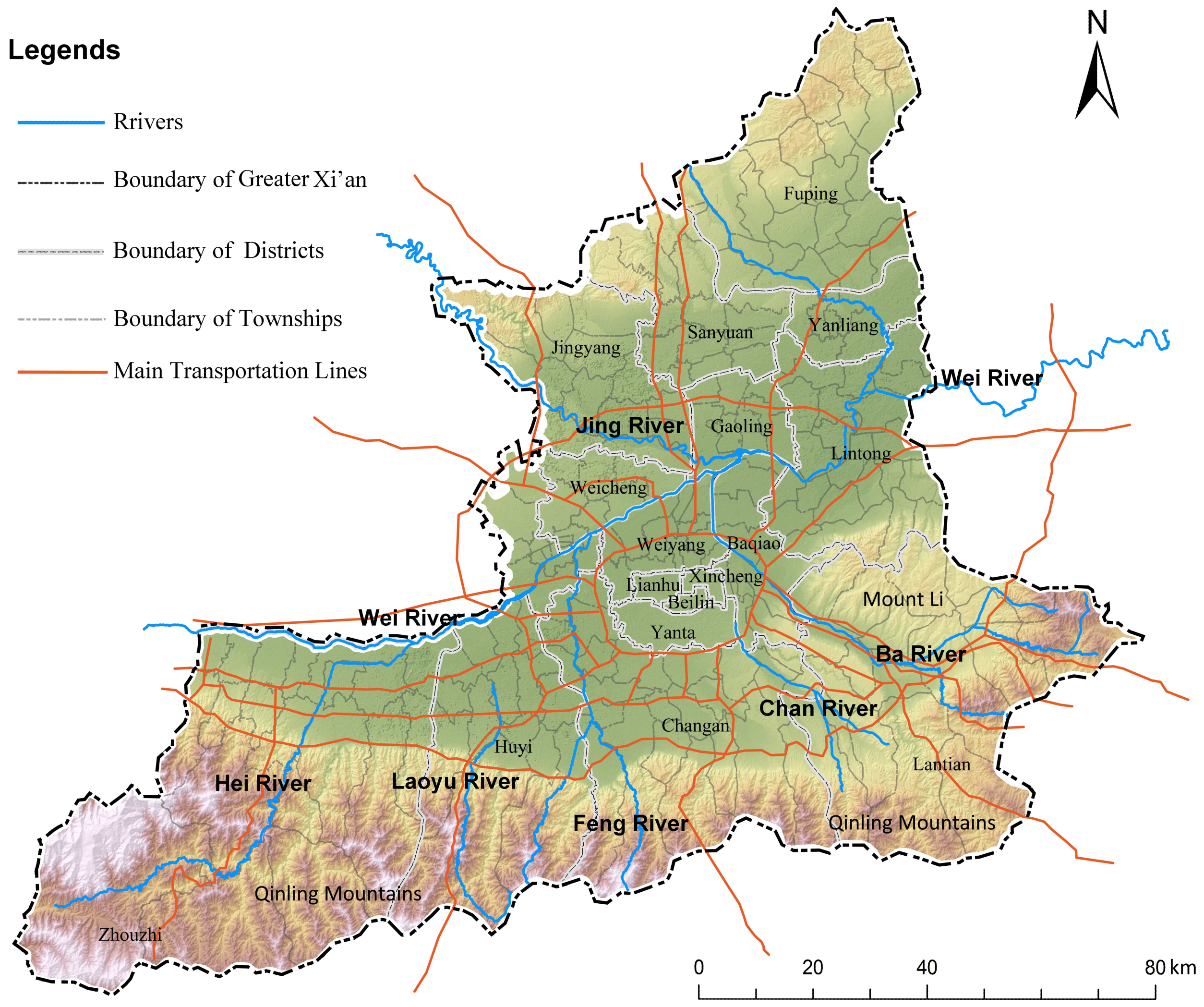
The greater Xi’an metropolitan area is located in the heart of China, with Xi’an, the starting point of the Belt and Road, as its core city, and the surrounding districts and counties of Xianyang city and Weinan city. The greater Xi’an area includes the 11 districts and counties of Xi’an city, Sanyuan County, Jingyang County, Weicheng District, Qindu District of Xianyang City, and Fuping County of Weinan City, adding up to 244 townships and subdistricts (see Figure 1). There is a total of 13.3 million km2 of land and 11.2 million people. The agricultural development in this area has a long history, and the development of modern urban agriculture is becoming more and more mature. It also has rich historical and cultural resources and natural landscape resources.
Rural cultural landscape is the concentrated embodiment of local conditions and customs which attached to the natural scenery, and the carrier of regional culture. Exploiting rural cultural landscape and realizing the renaissance of rural culture are important paths for the sustainable, high-quality, and value-added development of rural tourism. The greater Xi’an area is located at the south foot of the Qinling Mountains, with Wei river running through it. There are Ba, Chan, Jing, Feng, Lao, Ju, Gao, and other rivers flowing past, while it also includes diverse landforms like high and low mountains, valleys, plains, and Loess Plateau hilly ground terrain.
Mining different types of tourism-related big data to extract useful information is prevalent and promising for tourism research [22,23,24]. Big data as an emerging paradigm that is reshaping the theory and practice of tourism research can be assumed to be the basis for improving the quality of research outcomes as well as enhancing the tourism development of products and services [25,26,27]. Big data with geographic location information, such as consumer review website data and points of interest (POI) data, has emerged as a major data source in the tourism industry [28,29]. Due to the data availability, this paper mapped and delineated rural cultural landscape and rural tourism by using the big data from the social media platform of Dianping.com (accessed on 30 November 2019), Baidu map POI (accessed on 30 November 2019), and other geotagged website data through the support of the platform of geographic information system (GIS).
The research data used in this paper mainly included Baidu POI (points of interest), the Dianping comment webpage data, other webpage data, and basic geographical data. Baidu map web service API provides developers with http/https interface to retrieve search data in json or xml format. We used the multiscene point of interest (POI) search function provided by the Baidu Place API service to obtain almost 3000 pieces of data. Dianping.com is an ecommerce network connecting online and offline, covering nearly 200 categories in 2800 cities and counties across China. We obtained 2285 pieces of data covering cultural tourism related categories, all of which contained attribute data. Other webpage data came from the China Geographical Identification Network (www.cgi.gov.cn, accessed on 29 November 2019), the Shaanxi Provincial Intangible Cultural Heritage Database (www.sxlib.org.cn, accessed on 2 December 2019), as well as other government administration websites.
The geographic information about the study area, such as the administrative district, rivers, and traffic lines was derived from OSM open source data (www.openstreetmap.org, accessed on 10 November 2019). The township street point data was derived from the sixth National Census Data of China. The topographic map based on the DEM digital elevation data was downloaded from the geospatial data cloud (www.gscloud.cn, accessed on 1 July 2019).
Culture is spatial. Mining different types of tourism-related emerging data to extract useful information was our study’s main topic. This study established a framework which involved the paradigm of rural cultural landscape including conception, identification, and analysis to realize a change of landscape from “invisible” to “spatial”. Cultural structure, system, and integration research are inseparable from the cultural spatial pattern. Cultural spatialization processes were the focus of this paper and are also an important innovation point. The related research on cultural landscape mostly kept to the level of “cultural symbolization”. The field of spatialization of cultural landscapes tends to be more abstract, and it is difficult to lower it to the level of townships. The following spatial granularity of representations caused the study of the spatial pattern of cultural landscapes to lack certain practical guidance.
The mapping of the cultural landscape was based on the spatialization of a large number of representative individual data points. The spatial recognition, expression, and feature research of the rural cultural landscape was realized by means of network big data containing spatial coordinates, including web data crawling and Baidu POI data and GIS platform and so on.
3. Mapping and Analysis
The meanings and concepts of rural, culture, and tourism are multidimensional and interrelated [1], and the rural tourism destinations are a matrix of rural cultural landscapes. On the basis of this, rural tourism destinations in Greater Xi’an are identified.
3.1. The Mapping of Rural Tourism
A total of 1980 data on rural tourism from points of interest and public comment network were obtained (up to 2019). As shown in Figure 2a, kernel density analysis in GIS platform was used to explore its spatial layout characteristics. Kernel function was applied to generate a continuous surface from discrete points, so as to calculate the data aggregation of the whole region. This paper attempted to obtain the planar distribution through the discrete point data. Kernel density analysis satisfied the requirement of this study due to the fact that the closer the tourism points are, the stronger the impact of industry radiation will show. In Figure 2b, the kernel density diagram generated by 1980 points is shown with a pixel size of 500 m and a bandwidth 10 km. The density value results were divided into nine categories by using the quantile statistics.
According to the kernel density map analysis, the spatial pattern of rural tourism destinations in greater Xi’an could be divided into three zones: agglomeration zone, diffusion zone, and discrete distribution zone. The agglomeration zone mainly includes the Huyi Disrict and Chang’an District in the northern foot of the Qinling Mountains. Along the Laoyu river, Feng river, and Taipingyu river is a highlight like a ray, and the strong agglomeration appears in Lingtong county and the Bailu tableland. The Qinling Mountains are a repository of natural and cultural resources, along which the urban agriculture, especially the themed agriculture and leisure agriculture, develop well. Based on these, the agglomeration zone is the most mature and large-scale rural tourism destination in the greater Xi’an region. The diffusion zone in the middle mainly extends along the Wei river, with tourism destinations in average distribution. Only in the north side of the urbanization area, close to the source of tourists, a small-scale agglomeration was formed by the radiation diffusion of the agglomeration zone. The discrete distribution zone is located in the middle and outer suburbs, with its distribution of tourism destinations being discrete and uneven. Some blind spots exist, making it difficult to form a scale. Poles were formed along important roads or in the intersection zone, mostly for the areas where there are only one or a few high-quality tourism destinations, such as Gaoling agricultural park.
3.2. The Mapping of Rural Cultural Landscape
Culture is spatial. Cultural structure, system, and integration research are inseparable from the cultural spatial pattern. Cultural spatialization processes were the focus of this paper and are also an important innovation point. The related research on cultural landscapes mostly kept to the level of “cultural symbolization”. The field of spatialization of cultural landscapes tends to be more abstract, and it is difficult to lower it to the level of townships. The following spatial granularity of representations caused the study of the spatial pattern of cultural landscapes to lack certain practical guidance.
The mapping of cultural landscape was based on the spatialization of a large number of representative individual data points. The spatial recognition, expression, and feature research of rural cultural landscape was realized by means of network big data containing spatial coordinates, including web data crawling and Baidu POI data and GIS platform and so on.
3.2.1. Agricultural Productive Cultural Landscape
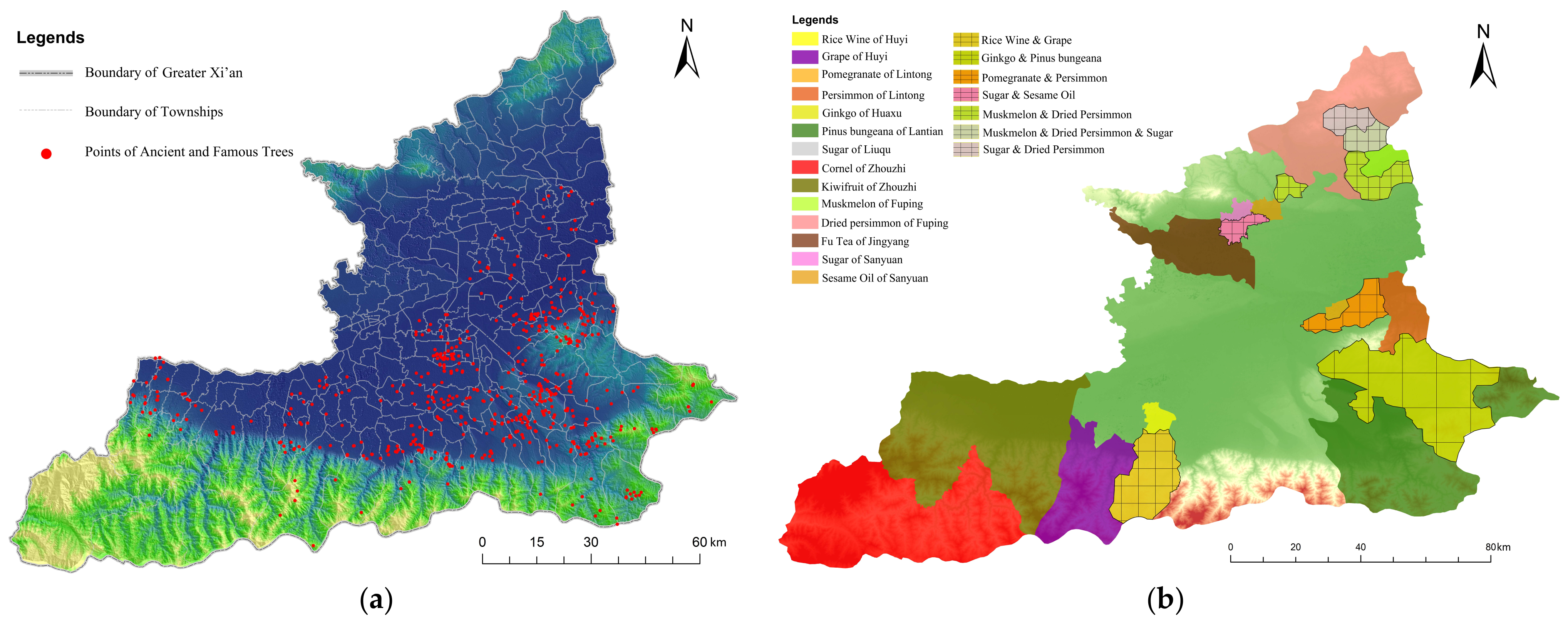
Based on the previous classification of rural cultural landscape, according to the natural environment features of the study area, two representative data of the ancient and famous trees and the geographical indication products were selected for spatial recognition of agricultural productive landscapes. The ancient and famous trees mainly demonstrated the forests, grazing, and fishing landscape in the greater Xi’an area, and the geographical indication products were the concentrated reflection of regional agricultural products and activities. Through a data crawling and cleaning process of these two data sets, the spatial expression of this type of cultural landscape was realized. According to China Protected Geographical Indication Products (www.cgi.gov.cn, accessed on 29 November 2019), there are 15 geographical indication agricultural products located in the greater Xi’an area (up to 2019). The ancient and famous trees data originated from Protection of The Ancient and Famous Trees of Xi’an, the official website of the Shaanxi Provincial Natural Resources Department (http://zrzyt.shaanxi.gov.cn/, accessed on 27 November 2019) and the official website of the Xi’an Natural Resources and Planning Bureau (http://zygh.xa.gov.cn/ptl/index.html, accessed on 27 November 2019).
Ancient and famous trees are important forestry resources. After a large area of forest disappeared and moved backward, Shaanxi Province preserved many tree monologues. The ancient and famous trees are not only historical witnesses of natural changes and successions, but also important social and cultural landscapes. They have unique ornamental aesthetic values and are often endowed with various anecdotes and historical memories to show their vitality and local customs. As an important agricultural productive cultural landscape, the ancient and famous trees which consist of aesthetic interest and historical cultural tastes, formed a unique “tree culture”. Through webpage data crawling, a total of 1027 data points of the ancient and famous trees were obtained, and the distribution of the 914 points remaining after data cleaning is shown in Figure 3a.
Geographical indication products are formed by both the local characteristic natural conditions and the typical humanistic environment. They are the embodiment of regional comparative advantage resources and the agricultural primary and processed products which match the actual productivity. Different types of crops and products have distinct colors and morphological characteristics, that is, orchards, woodland gardens, workshops, etc., all have easily recognizable landscape differences and characteristics. The geographical indications are specialized regional production brands certified by professional institutions and the most intuitive and representative reflection of the agricultural productive cultural landscape. Like social culture and technology culture, the “livelihood culture” represented by the agricultural productive process and its products is an important type of regional culture. The greater Xi’an area has a long history of farming production and processing. These agricultural products occupy different spatial areas and have obvious diversity characteristics, as shown in Figure 3b.
3.2.2. Rural Ecological Landscape
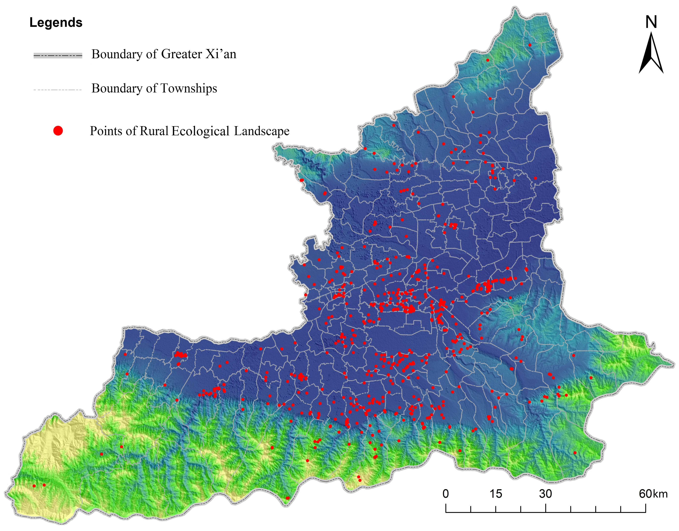
Rural ecological landscape is composed of various unique places which are an important embodiment of rural tangible culture and “rurality” such as settlement landscape, architectural landscape, and human relics. This type of cultural landscape contains more specific content. Furthermore, the POI (points of interest) from the ‘Web Service API’ interface of Baidu Map Open Platform (http://lbsyun.baidu.com/, accessed on 30 November 2019) and Dianping web data can be obtained according to the classification of the previous article. After filtering out duplicate, redundant, invalid, spatial mismatch, and other data, 2440 pieces of original data diminished to a total of 702 valid data points, and their specific distribution is shown in Figure 4.
We used the GIS platform to analyze the data points by kernel density analysis. Setting the pixel size to 450 m and the bandwidth to 10 km to realize the spatial expression of the rural ecological landscape of greater Xi’an and to explore its regional spatial characteristics. The rural ecological landscape in the greater Xi’an area has three types of landscape culture areas with strong specialization from north to south: sites and relics culture areas on the northern Wei River; Zhou, Qin, Han, and Tang dynasties culture areas; and the religious and traditional settlement culture areas in the northern Qinling Mountains.
3.2.3. Farmer Creative Landscape
Farmer creative landscape is a cultural type with strong vitality, regional embeddedness, and rich expressiveness. It belongs to intangible and immaterial culture. Represented by folk customs and folk skills, this landscape type is an important expression of the Chinese traditional agricultural civilization of local and regional cultural characteristics, reflecting the wisdom, innovation, and character of the laboring people. The protection, communication, and inheritance of traditional rural culture are being impacted and interfered with by marketization and excessive commercialization. It intuitively reflects the structural change of the cultural landscape. Hence, it is of great significance for the revival of rural culture to explore the spatial characteristics of this landscape and seize the landscape context.
This paper took a total of 148 intangible cultural heritages at provincial and national levels in greater Xi’an as data (up to 2019), and carried out the spatial expression data by GIS spatial analysis module. Different from the material cultural landscape, the intangible cultural landscape is not restricted to a fixed space or site, but is an important aspect of regional vitality space. On account of geographical isolation, restrictions on the level of socio-economic and historical development, poor information exchange, and other factors, the same cultural landscape type has a strong identity and dissemination degree in a relatively small range. This scope is roughly the spatial scale of the township level, while in the district or county level or larger scale, the sense of identity rapidly decreases, and there are obvious cultural grade differences. It can be summarized as the spatial characteristics of “small similarities but large differences”. From this, spatial interpolation analysis of GIS platform was implemented to realize the transformation from discrete points with spatial attributes to continuous planar data layers, as shown later.
4. Results
Cultural spatialization processes were the focus of this paper and are also an important innovation point. The related research on cultural landscape mostly kept ti the level of “cultural symbolization”. Based on the spatialization by means of a variety of spatial analysis methods, our results of mapping the spatial characteristics of cultural landscape realized the change from “invisible” to “spatial”.
4.1. The Feature Research of Agricultural Productive Cultural Landscape
The Thiessen polygons is one of the models for establishing an aggregated region. It prefers that each polygon contains only one data point, and any position in the polygon is closer to its associated point than the point of any other polygon. Therefore, the smaller the polygon area is, the larger the data point aggregation degree will be. When constructing the Thiessen polygons of the ancient and famous trees data points, we selected a geometric area of less than 10 square kilometers which was the ancient and famous trees landscape cluster area.
As shown in Figure 5, the landscape of agricultural productive products and production activities is mainly distributed in the outer areas of greater Xi’an, including Fuping, Jingyang, and Sanyuan County located in the north, Zhouzhi and Huyi County located in the southwest, and Lintong and Lantian County located in the southeast. The “curve”, from Mount Li to the northern part of the Qinling Zhongnan Mountain, is the main gathering area of the ancient and famous trees cultural landscapes. As shown in Figure 5, the range of Cuifeng Town, Qinghua Town, and Louguan Town of Zhouzhi County, and Jiangcun Town and Pangguang Town of Huyi District formed the small-scale gathering area. The high and large-scale concentration areas appeared in the range of Chang’an, northwestern Lantian County, and southern Lintong County. Together, they formed a ‘core cultural origin’ of greater Xi’an.
The agricultural productive cultural landscape of the greater Xi’an area has obvious regional space aggregation, where the regional culture is highly integrated. There are three landscape cultural areas independent of each other: cultural zone of production techniques in the north with Fuping, Sanyuan, and Jingyang County as the source, the flower and fruit cultural area in the southwest with Zhouzhi and Huyi County as the source, and the forest and fruit culture area in the southeast with Chang’an, Lantian, and Lintong County as the core. The landscapes within these three types of cultural districts have a higher degree of homogenization and a lower level of richness and diversity.
Fuping, Sanyuan, and Jingyang County are located in the Guanzhong Plain, north of the Wei River, in which the plains and loess terraces are developed. The agricultural production has a long history, and the farming civilization is resplendent there. Based on traditional food crops and economic crop cultivation, the local people have exerted their strong agricultural productive creativity. This region produces Jing-wei Fu tea, pure sesame oil, and Qiongguo sugar famous throughout the country, and the cultural landscape of the region reflects the heavy production technology culture, as well as the atmosphere of the people. Zhouzhi and Huyi County are located at the northern end of the Qinling Mountains. The unique natural conditions allow for a high quality in the seedling flowers and kiwifruit, grapes, and other fruits of the area. The special cultural landscape of looming flowers and prosperous fruit provides people with a comprehensive display by their form, color, smell, and taste. Chang’an and Lantian County are located at the northern foot of the Qinling Mountains, and the Lintong County is located to the north of Mount Li, which is the brand of the Qinling Mountain. Forestry culture is the theme of this region. The ancient trees of hundreds of years share stories, and the combination of persimmon, pomegranate, Pinus bungeana, and ginkgo tree colors together formed the cultural connotation with historical, economic, and aesthetic values.
4.2. The Feature Research of Rural Ecological Landscape
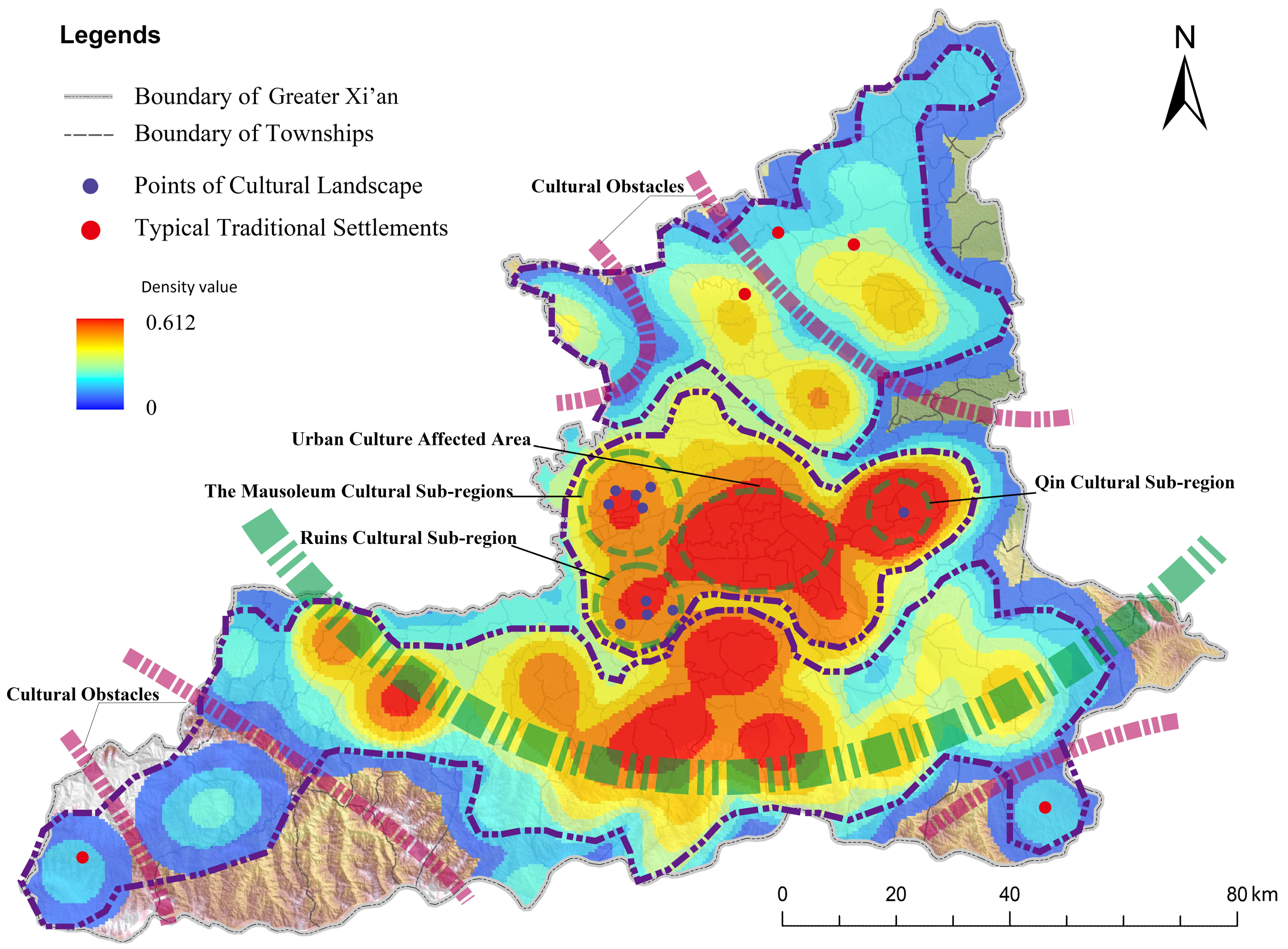
Our mapping research demonstrated that the rural ecological landscape in the greater Xi’an area has three types of landscape culture areas with strong specialization from north to south: sites and relics culture areas on the northern Wei River; Zhou, Qin, Han, and Tang dynasties culture areas; and the religious and traditional settlement culture areas in the northern Qinling Mountains.
The sites and relics cultural areas are located on the northern part of the Wei River, with Fuping and Sanyuan County as the cultural origin. In this area, several relics and mausoleum architectures such as Tang Xianling, Tang Duanling, and Panlongwan sites have been collected. Compared with the two types of cultural districts in the central and southern parts of greater Xi’an, it is scattered, lacking a cultural core area with large spatial scale and influence. The remains of the ruins and the landscape of the mausoleum have been damaged throughout history, and there are inherent defects such as incomplete landscapes and no obvious cultural genes. These lead to the spatial characteristics of the cultural landscape becoming isolated and fragmented. There are more obvious cultural obstacles in this area, which creates cultural space isolation and cuts off cultural exchanges, making the integration and diffusion of the regional culture difficult and leading to a more fragile culture.
The Zhou, Qin, Han, and Tang dynasties cultural areas are in the central hinterland of the greater Xi’an area that gathers important historical relics and cultural imprints of the Zhou, Qin, Han, and Tang Dynasties. This area is not only an important cultural core area of greater Xi’an, but also a central area of Chinese civilization and culture. It has a rich cultural heritage and historical accumulation. Based on the specific analysis of the cultural landscape points, this cultural area contains three typical cultural landscape sub-regions, which are the ruins cultural subregion and the mausoleum cultural subregion in the west, the Qin cultural subregion in the east, and urban culture affected area in the middle.
The mausoleum cultural subregions are in and around Zhouling subdistrict, Weicheng District, and Xianyang City. From top to bottom and left to right, there is the Kangling, Yanling, Yilingr, Zhouling, and Baiqi tombs. The ruins cultural subregion is in the vicinity of the Doumen and Sanqiao subdistricts in the Chang’an District. From top to bottom and left to right are the Fenggao Site, Kunming Pool Site, A fang Palace Site, and Taiye Pool Site. The Qin culture subregion spread around the Mausoleum of the Qin Shi Huang. These three types of cultural landscapes have high landscape quality, are high clustering and thematic, have an obvious radiation diffusion effect, and scale corresponding to tourism projects. The central urban culture affected subregion has a high level of urbanization with partly or completely urbanized areas which are affected by urban culture and excessive commercialization. It can be seen from the specific landscape points of the spatial pattern map (Figure 6) that a large number of assimilated and simplified commercial development projects are carried out around traditional cultural landscapes, resulting in a decrease in the level of their value.
The religious and traditional settlement culture areas in the northern Qinling Mountains distributed in the Lantian, Zhouzhi, Chang’an, and Huyi counties of Xi’an, according to the trend of the Qinling Mountains, form a core area of cultural landscape and cultural origin in the form of an “Arc”. The area contains many buildings and places of high quality and historical significance in Buddhism and Taoism, in which six of the eight major birthplaces of Buddhism are located. They are preserved in the Houzhenzi Town of Zhouzhi County, Bailu tableland, Lantian County, and other traditional settlements with spatial structure and overall appearance, as shown in Figure 6.
The traditional settlement landscape is a holistic and concentrated reflection of traditional culture and historical features which has a distinct regional character. The traditional Chinese village catalogue full of famous Chinese towns and villages in history and culture that are typical traditional settlements selected and verified by the authoritative department. As of January 2019, the five villages in greater Xi’an which were selected for the above list are old county town village in Zhouzhi County, Shichuangou Village in Lantian County, Baishe Village and Dongli Village in Sanyuan County, and Lianhu Village in Fuping County. Analysis of the spatial characteristics of typical traditional village landscapes revealed that the traditional settlement landscapes tend to be spatially marginalized. Furthermore, there are obvious cultural barriers between cultural core areas. It reflected that the protection of these landscapes tends to be isolated protection while neglecting the overall protection of the spatial network [7]. It results in the spatial characteristics of the cultural landscape to be “fragmented” and “insularized”.
4.3. The Feature Research of Farmer Creative Landscape
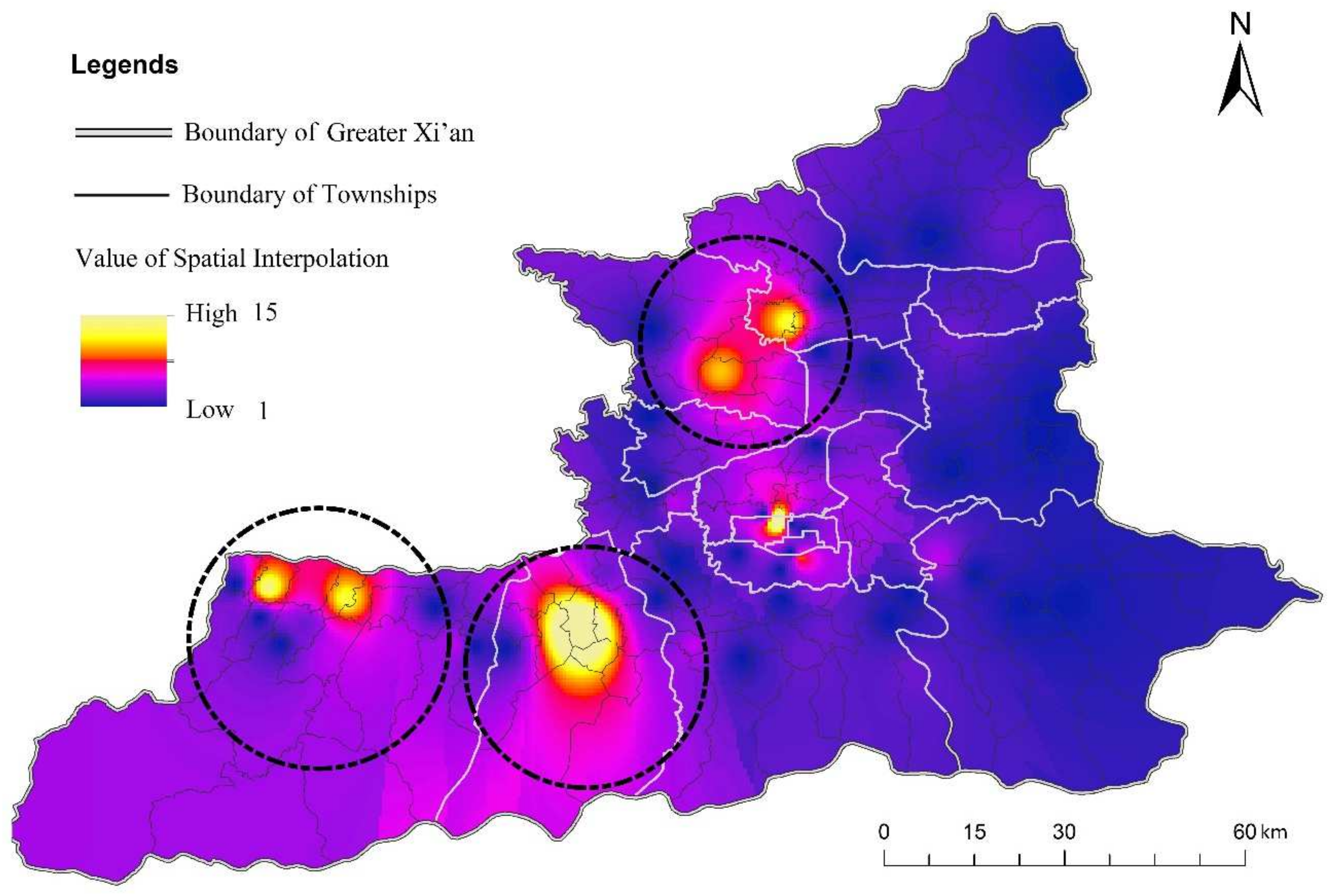
Based on what is known in the previous section, famer creative landscape has its own spatial characteristics of “small similarities but large differences”. From this, for each cultural landscape data point, we delineated the spatial subordination relationship at the township level and provided the appropriate spatial attributes. Then, the spatial interpolation analysis of GIS platform was implemented to realize the transformation from discrete points with spatial attributes to continuous planar data layers. The inverse distance weight interpolation method in GIS spatial interpolation satisfied the requirement of the “small similarities but large differences”. The spatial range adjacent to villages and towns with statistics point was greatly affected and formed a continuous data surface. While the farther range had a smaller impact, and the surface of the form was more smooth and obscure. Thus, an intuitive and reasonable spatial distribution of farmer ecological cultural landscape was obtained, as shown in Figure 7.
In this figure, color difference degree (also known as local surface fineness) expressed the degree of relative convergence of the data points. The high-value aggregation area is depicted by the form of dull colored surroundings serving as a foil to a high brightness area.
Except for the high-value aggregation present in completely urbanized areas, it was easily found that there are four high-value aggregation areas, and the space characteristics of farmer creative landscape in greater Xi’an can be expressed through the picture shown above.
There is a popular saying in Shaanxi, “Zhouzhi County is like gold, Huyi District is like silver, Jingsanyuan is like cabbage heart”. It vividly describes the unique natural and geographical conditions of Zhouzhi County, Huyi District, Jingyang County, and Sanyuan County in the Guanzhong Plain of the Shaanxi Province and the resplendent traditional farming civilization. The research results of this paper were in good agreement with the scenes described in this proverb. On the basis of the actual research and data analysis, the farmer creative landscape can be divided into three main important cultural core areas: Jingsanyuan vitality area, Huyi vitality area, and Zhouzhi vitality area.
Farmer creative landscape is a vivid display of the integration of traditional Chinese agricultural civilization and local cultural characteristics. It is also an important approach to understanding the wisdom, innovation, and character of the laboring people in various regions. In the process of multicultural conflict and integration, it is an important method to promote the cultural selfconfidence of China by protecting regional characteristic culture and developing distinctive farmers’ cultural tourism resource-intensive industries. It could be an important media on the development of the cultural tourism industry in today’s society.
4.4. Solutions That Promote the Cultural Quality of Rural Tourism
Fatimah evaluated the impacts of rural tourism activities on cultural landscape sustainability and the landscape changes and transformation were known and clarified [30]. Significantly, five types of changes were found: addition, continue, customize, transform, and repair. Meanwhile, uncontrolled tourism development should be cautious.
- (1)
- Rural tourism prefers rural ecological cultural landscape.
It was found that the agglomeration zone of rural tourism in greater Xi’an is mainly located in the comprehensive spatial area of agriculture, farmer, and countryside landscape. Landscape diversity is of great significance to the development of rural tourism. The central diffusion zone of rural tourism in the middle almost overlaps with the rural cultural landscape, and they are highly dependent. The most attractive landscape resources for the development of rural tourism are these traditional rural settlements, traditional buildings, ruins and farmland, gardens, etc. Development of rural tourism is conducive to the protection of such landscape resources and the export of local culture.
- (2)
- Cultural landscape synthesis is the potential development area of rural tourism, which plays an important role in promoting the cultivation of new rural tourism highlands.
The west of Jingsanyuan and Zhouzhi County is a complex space of farmer culture and agricultural culture landscape, and also has the “beauty” of agricultural culture landscape and the “spirit” of farmer culture landscape. The diversity of the landscape shows a strong cultural charm, and it is a potential area for the development of rural tourism. However, it is far from the source of tourists, and is affected by the solidification of the current rural tourism development mode, the tourism industry is developing slowly for the time being. Henceforth, the above-mentioned areas should explore new tourism modes according to their own advantages of cultural landscape combination, so as to form a new highland of rural tourism and promote a new situation of tripartite confrontation of rural tourism in the greater Xi’an region.
- (3)
- Agricultural productive landscape in rural tourism region tends to be fragmented.
Agricultural productive landscape in the agglomeration area of rural tourism is mainly dominated by scattered ancient and rare trees of cultural landscape classification, while agricultural activities appear with spatial fragmentation and spatial blind areas of “agricultural landscape missing island”. With the rapid development of rural tourism, land-use mode and rural spatial structure have changed a lot, as well as the evolution of the cultural landscape spatial pattern. Hereon the agricultural landscape at the northern foot of the Qinling Mountains has been hit to the hardest degree, with its landscape pattern continuity obviously destroyed.
- (4)
- The development of rural tourism lacks excavation, refinement, and display of regional spatial thematic culture.
The analysis results above showed that the rural cultural landscape of greater Xi’an contains many regional thematic cultural areas with obvious spatial characteristics, which are the core source of traditional rural culture. Its cultural characteristics should be refined and displayed in the regional space. However, according to actual investigation and interview, it was found that the rural tourism industry in greater Xi’an lacks respect for the traditional rural culture and continues the excavation and sublimation of special rural culture sources. This is one of the reasons for the problems of rural tourism homogenization, its low grade, and the gradual loss of “rurality”.
5. Discussion
5.1. Theoretical Contributions
Ringer (2013) said that it is encouraging to see research in which the theories and ideas from cultural geography are discussed within the context of tourism. Initially, we worked on exploring, integrating, and reviving rural culture. It is already known through previous research that the meanings and concepts of rural, culture, and tourism are multidimensional and interrelated, and the cultural landscape exists as a complex in rural areas. In terms of concepts and meanings, figuring out what the rural cultural landscape is and what it contains is an important and difficult issue.
At this point, the main task and achievement of this paper was to classify the rural cultural landscape into three types, and they are agricultural productive landscape, rural ecological landscape, and farmer creative landscape. On the basis of this, we then inventoried and mapped the quality, quantity, and geographic distribution of rural cultural landscapes in the context of rural tourism and, subsequently, identified spatial structural features between cultural landscapes and rural tourism, and then finally proposed solutions that promote the cultural quality of rural tourism and the cultural revitalization of rural areas.
5.2. Practical Contributions
Culture landscapes are composed of tangible material landscapes and non-material intangible landscapes. Culture is spatial but non-material intangible landscapes are invisible. The identification and delineation of cultural landscape often emphasized the tangible part but neglected the intangible and non-material part, which is the core of a cultural landscape. Therefore, the mapping and modeling of non-material benefits such as scenic beauty, heritage, leisure and its associated subjective dimensions raised numerous challenges.
Mining different types of tourism-related emerging data to extract useful information was our study’s main topic. This study established a framework which involved the paradigm of rural cultural landscape including conception, identification, and analysis to realize a change of landscape from “invisible” to “spatial”. Spatialization processes were the focus of this paper and are also an important innovation point. The related research on cultural landscape mostly kept to the level of “cultural symbolization”.
Due to technical limitations, the research of cultural landscape has a trade-off between spatial resolution in a large-scale area. Specifically, there has been a lack of spatial perception of rural tourism and rural culture, especially in developing countries, which has been detrimental to cultural preservation and economic development. The field of spatialization of cultural landscapes tends to be more abstract, and it is difficult to lower it to the level of townships. The following spatial granularity of representations causes the study of the spatial pattern of cultural landscapes to lack a certain practical guidance.
In our research, the mapping of the cultural landscape was based on the spatialization of a large number of representative individual data points. The spatial recognition, expression, and feature research of rural cultural landscape was realized by means of network big data containing spatial coordinates, including web data crawling and Baidu POI data and GIS platform and so on.
5.3. Limitations
The present study also has several limitations. Due to the inaccessibility and lack of manpower for rural research, we found in our follow-up study that spatialization of cultural landscapes requires extensive data, constantly updated technology, and field research to support. Rural cultural landscape has a wide range of contents, in our subsequent research, we will continue to strengthen our attention to the rural area and culture, as well as our understanding of space.
6. Conclusions
Based on the research results of human geography, landscape planning, and architecture, this paper focused on rural cultural landscape, subdividing rural cultural landscape into agricultural productive landscape, rural ecological landscape, and farmer creative landscape. Culture is an abstract spatial form and differs from it. We implemented multiple new data and GIS spatial analysis technology for different types of rural cultural landscape. Additionally, we used spatial recognition and spatial characteristic analysis, making clear spatial pattern characteristics of cultural landscape, dividing different culture zonings, and presenting the spatial differentiation and geographical features of the cultural landscape. These frameworks all provide a research basis on the process of demonstration, integration, and reconstruction of rural culture. As a consequence, this paper analyzed the relationship between rural tourism and cultural landscape from different perspectives of promotion and suppression and provides some advice to the strategic basis for rural tourism development.
Author Contributions
Data curation, B.F.; Formal analysis, T.S.; Funding acquisition, W.Y.; Investigation, J.L.; Project administration, W.Y.; Writing–review and editing, J.T. All authors have read and agreed to the published version of the manuscript.
Funding
This research was funded by the National Science Basic Research Plan in Shaanxi Province (Grant No. 2021JM-066) and the Fundamental Research Fund for the Central Universities (Grant No. G2015KY0007).
Acknowledgments
We acknowledge financial supports from the National Science Basic Research Plan in Shaanxi Province (Grants No. 2021JM-066) and the Fundamental Research Funds for the Central Universities (Grants No. G2015KY0007).
Conflicts of Interest
The authors declare no conflict of interest.
References
- MacDonald, R.; Jolliffe, L. Cultural rural tourism: Evidence from Canada. Ann. Tour. Res. 2003, 30, 307–322. [Google Scholar] [CrossRef]
- Sharpley, R.; Sharpley, J. Rural Tourism. An Introduction; International Thomson Business Press: London, UK, 1997. [Google Scholar]
- Ringer, G. Destinations: Cultural Landscapes of Tourism. Destin. Cult. Landsc. Tour. 2013, 4, 1–196. [Google Scholar] [CrossRef]
- Huang, Z.F.; Lu, L.; Su, Q.; Zhang, J.H.; Sun, J.X.; Wan, X.C.; Jin, C. Research and development of rural tourism under the background of new urbanization: Theoretical reflection and breakthrough of predicament. Geogr. Res. 2015, 34, 1409–1421. [Google Scholar] [CrossRef]
- Zheng, C.Q.; Luo, P.P.; Wu, S.Y. Dilemma and solution of rural culture preservation and development in the process of urbanization. West Forum 2008, 3, 27–29. [Google Scholar]
- Sai, J.T. Cultural Materials and Its Expression in Rural Tourism; Beijing Forestry University: Beijing, China, 2005. [Google Scholar]
- Wang, Y.C.; Patrick, M.; Brian, K. The Traditionality Evaluation of Culture Landscape Space and Its Holistic Conservation Pattern: A Case Study of Qiandeng-Zhangpu Region in Jiangsu Province. Acta Geogr. Sin. 2011, 66, 525–534. [Google Scholar] [CrossRef]
- Hernik, J.; Gawroński, K.; Dixon-Gough, R. Social and economic conflicts between cultural landscapes and rural communities in the English and Polish systems. Land Use Policy 2013, 30, 800–813. [Google Scholar] [CrossRef]
- Nunta, J.; Sahachaisaeree, N. Cultural Landscape, Urban Settlement and Dweller’s Perception: A Case Study of a Vernacular Village in Northern Thailand. Procedia-Soc. Behav. Sci. 2012, 42, 153–158. [Google Scholar] [CrossRef] [Green Version]
- Tieskens, K.F.; Schulp, C.J.E.; Levers, C.; Lieskovský, J.; Kuemmerle, T.; Plieninger, T.; Verburg, P.H. Characterizing European cultural landscapes: Accounting for structure, management intensity and value of agricultural and forest landscapes. Land Use Policy 2017, 62, 29–39. [Google Scholar] [CrossRef] [Green Version]
- Vlami, V.; Kokkoris, I.P.; Zogaris, S.; Cartalis, C.; Kehayias, G.; Dimopoulos, P. Cultural landscapes and attributes of “culturalness” in protected areas: An exploratory assessment in Greece. Sci. Total Environ. 2017, 595, 229–243. [Google Scholar] [CrossRef]
- Zhou, T.; Koomen, E.; van Leeuwen, E.S. Residents’ preferences for cultural services of the landscape along the urban–rural gradient. Urban For. Urban Green. 2018, 29, 131–141. [Google Scholar] [CrossRef]
- Daugstad, K. Negotiating landscape in rural tourism. Ann. Tour. Res. 2008, 35, 402–426. [Google Scholar] [CrossRef]
- Sun, Y.H.; Chen, T.; Wang, Y.C. Progress and Prospects in Research of the Traditional Rural Cultural Landscape. Prog. Geogr. 2008, 6, 90–96. [Google Scholar] [CrossRef]
- Huang, Z.F.; Huang, R.L. Research progress on rural culture in the context of rapid urbanization and tourism development: Academic debate and future research prospects. Geogr. Res. 2018, 37, 233–249. [Google Scholar] [CrossRef]
- Bachi, L.; Ribeiro, S.C.; Hermes, J.; Saadi, A. Cultural Ecosystem Services (CES) in landscapes with a tourist vocation: Mapping and modeling the physical landscape components that bring benefits to people in a mountain tourist destination in southeastern Brazil. Tour. Manag. 2020, 77, 104017. [Google Scholar] [CrossRef]
- Rescia, A.J.; Willaarts, B.A.; Schmitz, M.F.; Aguilera, P.A. Changes in land uses and management in two Nature Reserves in Spain: Evaluating the social-ecological resilience of cultural landscapes. Landsc. Urban Plan. 2010, 98, 26–35. [Google Scholar] [CrossRef]
- Carl, S. The Morphology of Landscape. Univ. Calif. Publ. Geogr. 1925, 2, 19–54. [Google Scholar]
- Chen, Y.J. Character Assessment and Planning of Rural Landscape; Tsinghua University: Beijing, China, 2012. [Google Scholar]
- Włodarczyk-Marciniak, R.; Frankiewicz, P.; Krauze, K. Socio-cultural valuation of Polish agricultural landscape components by farmers and its consequences. J. Rural. Stud. 2020, 74, 190–200. [Google Scholar] [CrossRef]
- Hsiao-Tung, F.; Chih-i, C. Earthbound China; Routledge: London, UK, 1998. [Google Scholar]
- Li, J.; Xu, L.; Tang, L.; Wang, S.; Li, L. Big data in tourism research: A literature review. Tour. Manag. 2018, 68, 301–323. [Google Scholar] [CrossRef]
- Lu, B.Y.; Wei, J.F.; Ming, Q.Z.; Guo, X.Y.; Liu, A.L. Research Progress of Tourism Big Data Application in China Based on Knowledge Map. Econ. Geogr. 2022, 42, 230–240. [Google Scholar] [CrossRef]
- Wang, L.J.; Zeng, G.J.; Bi, D.D. Spatial spillover effects of ICT on tourism industry growth. Acta Geogr. Sin. 2019, 74, 366–378. [Google Scholar] [CrossRef]
- Ardito, L.; Cerchione, R.; Del Vecchio, P.; Raguseo, E. Big data in smart tourism: Challenges, issues and opportunities. Curr. Issues Tour. 2019, 22, 1805–1809. [Google Scholar] [CrossRef] [Green Version]
- Ioanna, B.; Panagiota, D. The Influence of Tourist Trends of Youth Tourism through Social Media (SM) & Information and Communication Technologies (ICTs). Procedia-Soc. Behav. Sci. 2013, 73, 652–660. [Google Scholar] [CrossRef] [Green Version]
- Zhai, S.; Xu, X.; Yang, L.; Zhou, M.; Zhang, L.; Qiu, B. Mapping the popularity of urban restaurants using social media data. Appl. Geogr. 2015, 63, 113–120. [Google Scholar] [CrossRef]
- Yang, Y.; Liu, J.F. Several problems in the research and application of big data tourism. Tour. Trib. 2017, 32, 3–4. [Google Scholar]
- Wang, X.Y.; Cao, C.C. Domestic Tourist Market Structure and Spatial-temporal Characteristics of Tourism Flow in Qingdao City Based on Online Travel Notes. Sci. Geogr. Sin. 2019, 39, 1919–1928. [Google Scholar] [CrossRef]
- Fatimah, T. The Impacts of Rural Tourism Initiatives on Cultural Landscape Sustainability in Borobudur Area. Procedia Environ. Sci. 2015, 28, 567–577. [Google Scholar] [CrossRef] [Green Version]
Figure 1.
The greater Xi’an metropolitan area by its administrative and geographic characteristics.

Figure 2.
The POI of rural tourism (a) and the kernel density analysis of tourism points in GIS (b).
Figure 2.
The POI of rural tourism (a) and the kernel density analysis of tourism points in GIS (b).

Figure 3.
The points of ancient and famous trees (a) and the distribution of the geographical indication products (b).
Figure 3.
The points of ancient and famous trees (a) and the distribution of the geographical indication products (b).

Figure 4.
The distribution of rural ecological landscape points.

Figure 5.
Landscape of agricultural productive products and production activities.

Figure 6.
The spatial pattern of rural ecological landscape.

Figure 7.
Spatial pattern of farmer creative landscape.


Table 1.
Classification of rural cultural landscape by typologies (source: author).
| Landscape Type | Subcategory | Specific Contents |
|---|---|---|
| Agricultural productive landscape | Forest, husbandry, fishing landscape | Famous ancient trees, pastures, fishponds, etc. (varies by region) |
| Agricultural product | Agricultural primary products | |
| Agricultural processing products | ||
| Agricultural productive activity | Farming activities | |
| Agricultural productive technology | ||
| Rural ecological landscape | Traditional building and structure | Vernacular architecture |
| Religious building and site | ||
| Mausoleum building and site | ||
| Traditional municipal construction | ||
| Traditional, characteristic settlement | Traditional village | |
| Ethnic village | ||
| Characteristic industry town | ||
| Featured resources village | ||
| Ruins of the site | Archeological site | |
| Historic relic | ||
| Farmer creative landscape | Oral tradition | Language |
| Folk legend | ||
| Folk festival performance activity | Folk performing arts | |
| Folk activities | ||
| Folk festival | ||
| Folk knowledge and skill | Folk craft skills | |
| Folk traditional knowledge and practice |
Publisher’s Note: MDPI stays neutral with regard to jurisdictional claims in published maps and institutional affiliations. |
© 2022 by the authors. Licensee MDPI, Basel, Switzerland. This article is an open access article distributed under the terms and conditions of the Creative Commons Attribution (CC BY) license (https://creativecommons.org/licenses/by/4.0/).
Share and Cite
MDPI and ACS Style
Yang, W.; Fan, B.; Tan, J.; Lin, J.; Shao, T. The Spatial Perception and Spatial Feature of Rural Cultural Landscape in the Context of Rural Tourism. Sustainability 2022, 14, 4370. https://0-doi-org.brum.beds.ac.uk/10.3390/su14074370
AMA Style
Yang W, Fan B, Tan J, Lin J, Shao T. The Spatial Perception and Spatial Feature of Rural Cultural Landscape in the Context of Rural Tourism. Sustainability. 2022; 14(7):4370. https://0-doi-org.brum.beds.ac.uk/10.3390/su14074370
Chicago/Turabian StyleYang, Weili, Bing Fan, Jingbo Tan, Jing Lin, and Teng Shao. 2022. "The Spatial Perception and Spatial Feature of Rural Cultural Landscape in the Context of Rural Tourism" Sustainability 14, no. 7: 4370. https://0-doi-org.brum.beds.ac.uk/10.3390/su14074370
Note that from the first issue of 2016, this journal uses article numbers instead of page numbers. See further details here.