
Coevolution between Terraced Landscapes and Rural Communities: An Integrated Approach Using Expert-Based Assessment and Evaluation of Winegrowers’ Perceptions (Northwest Piedmont, Italy)


Abstract
:1. Introduction
1.1. Terraced Landscapes and Rural Communities
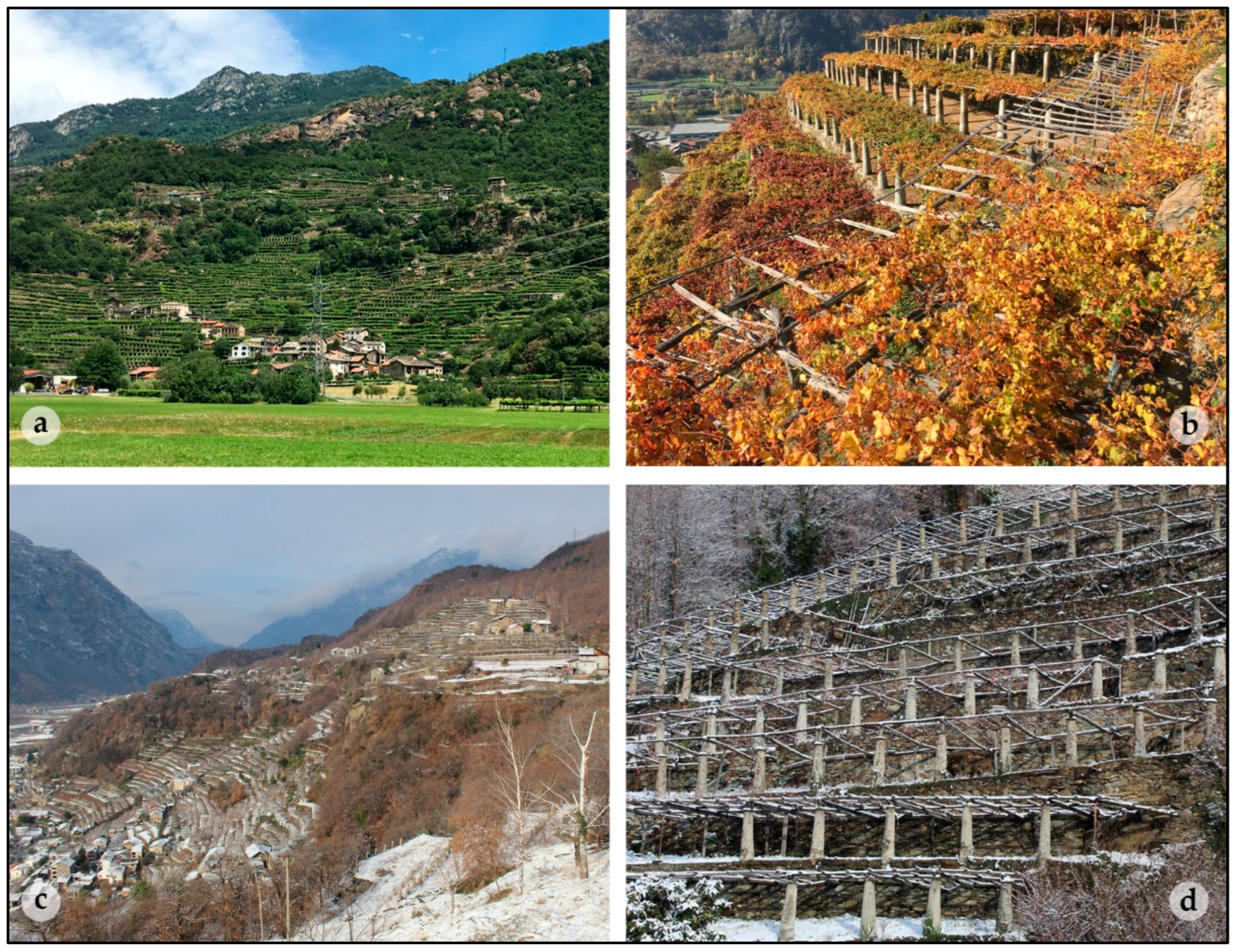
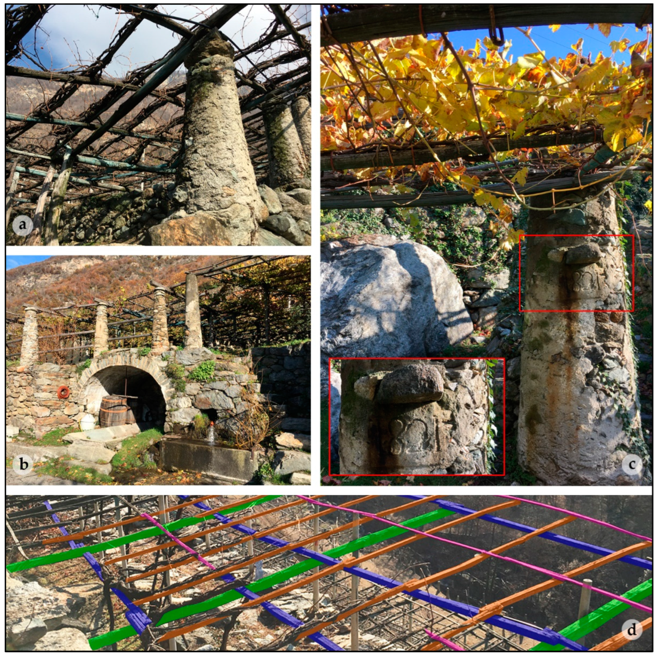
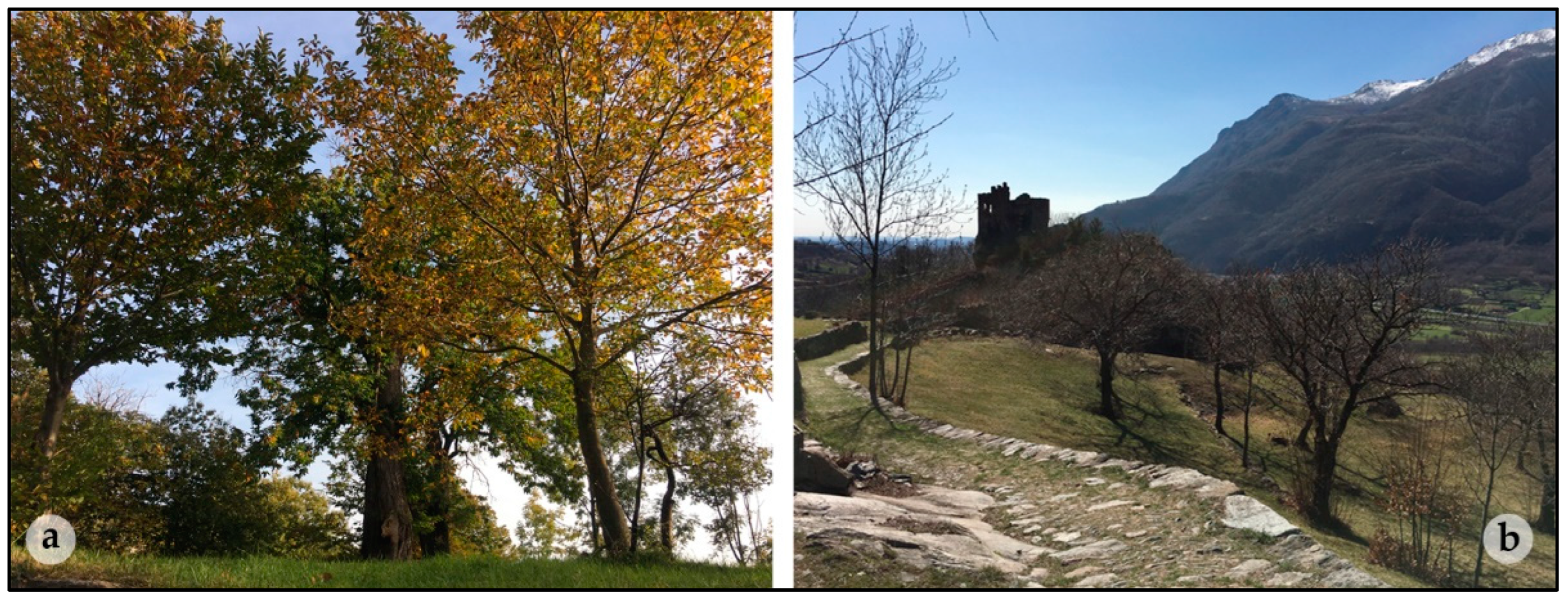
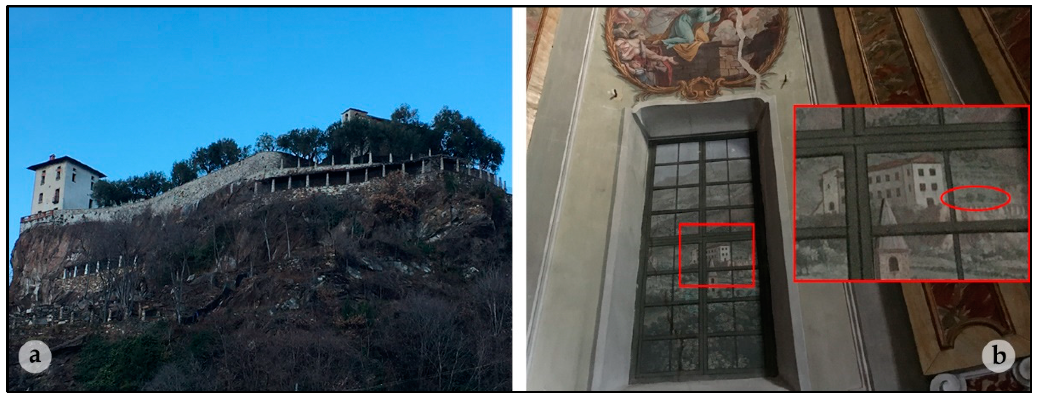
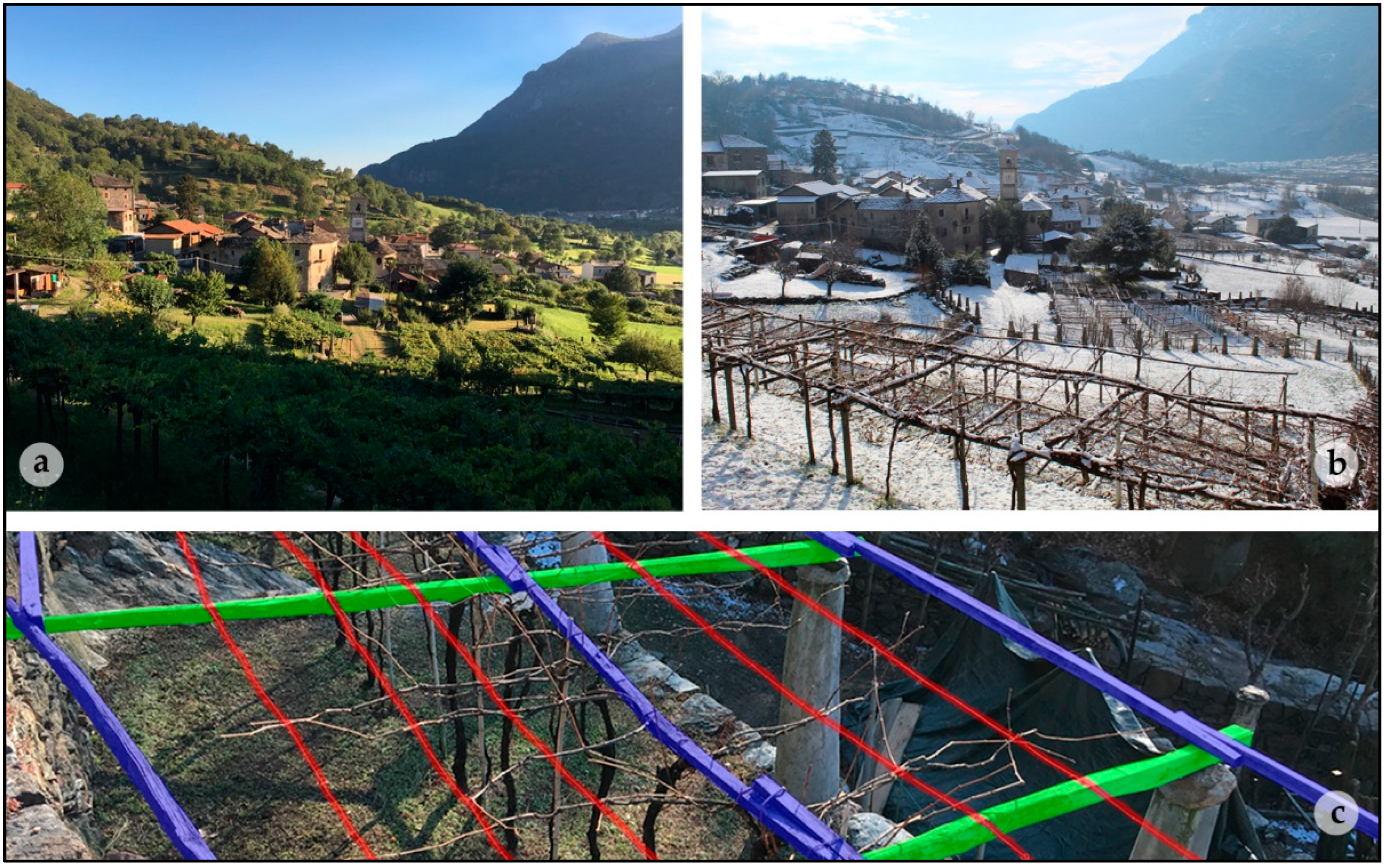
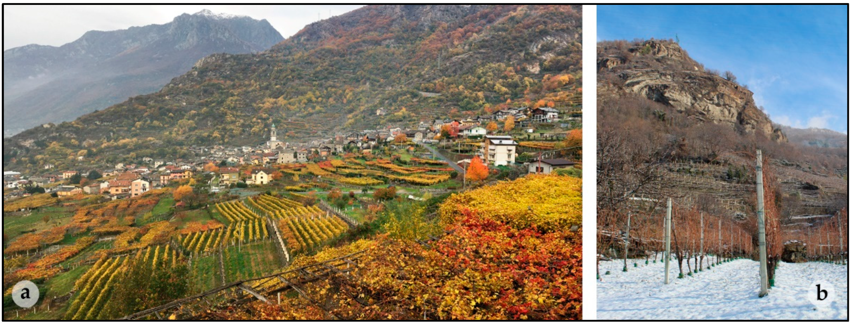
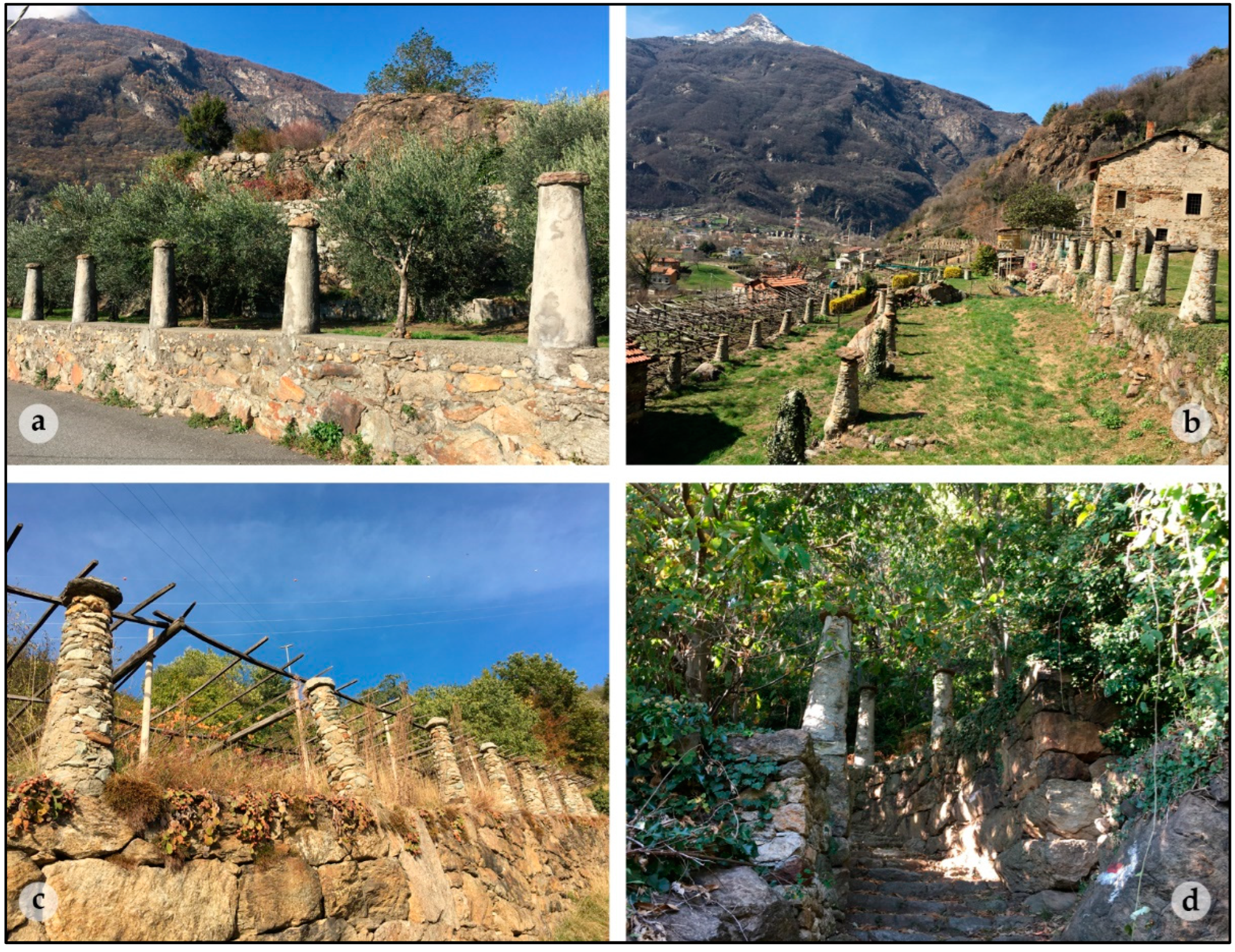
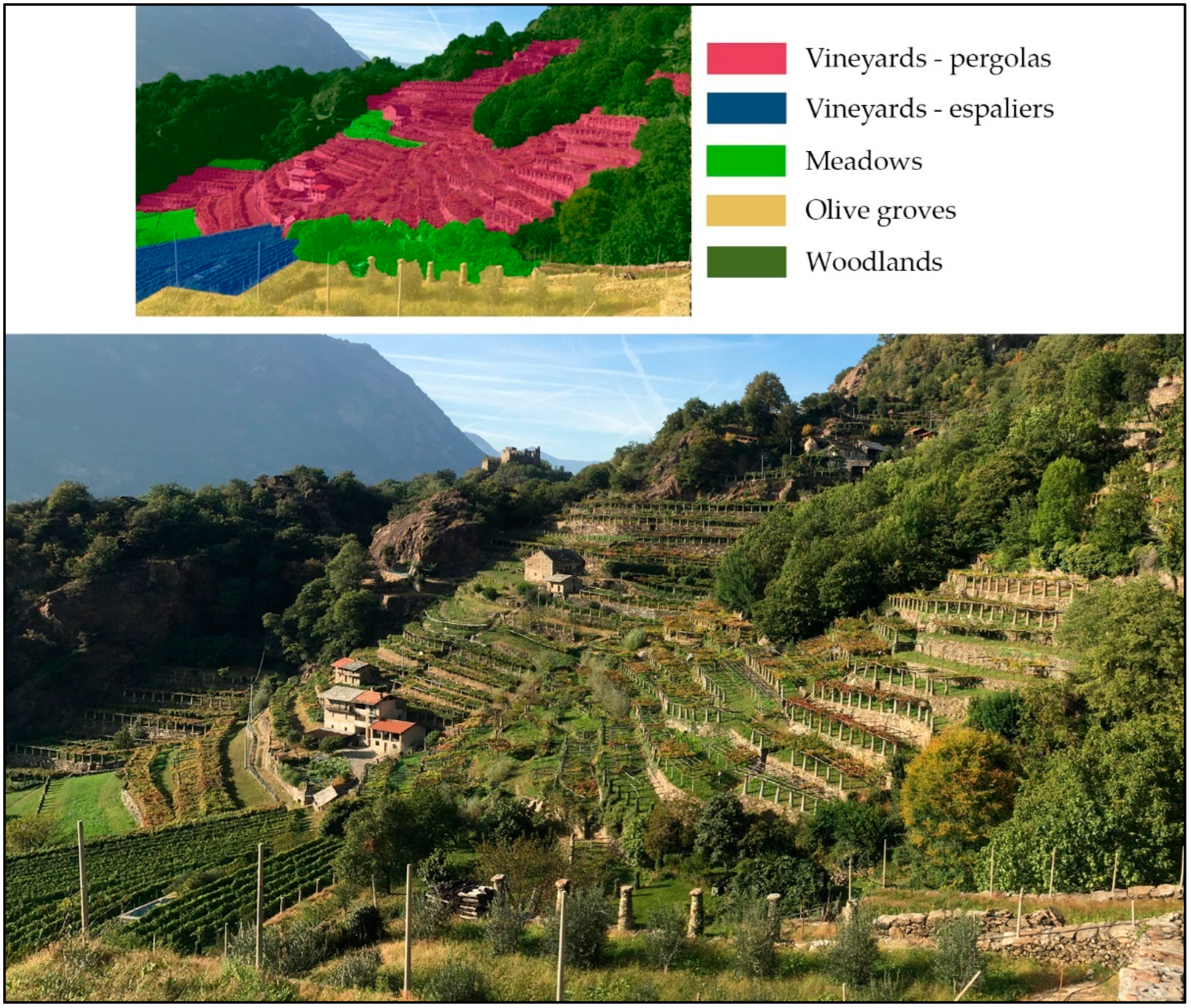
1.2. Case Study Area
2. Materials and Methods
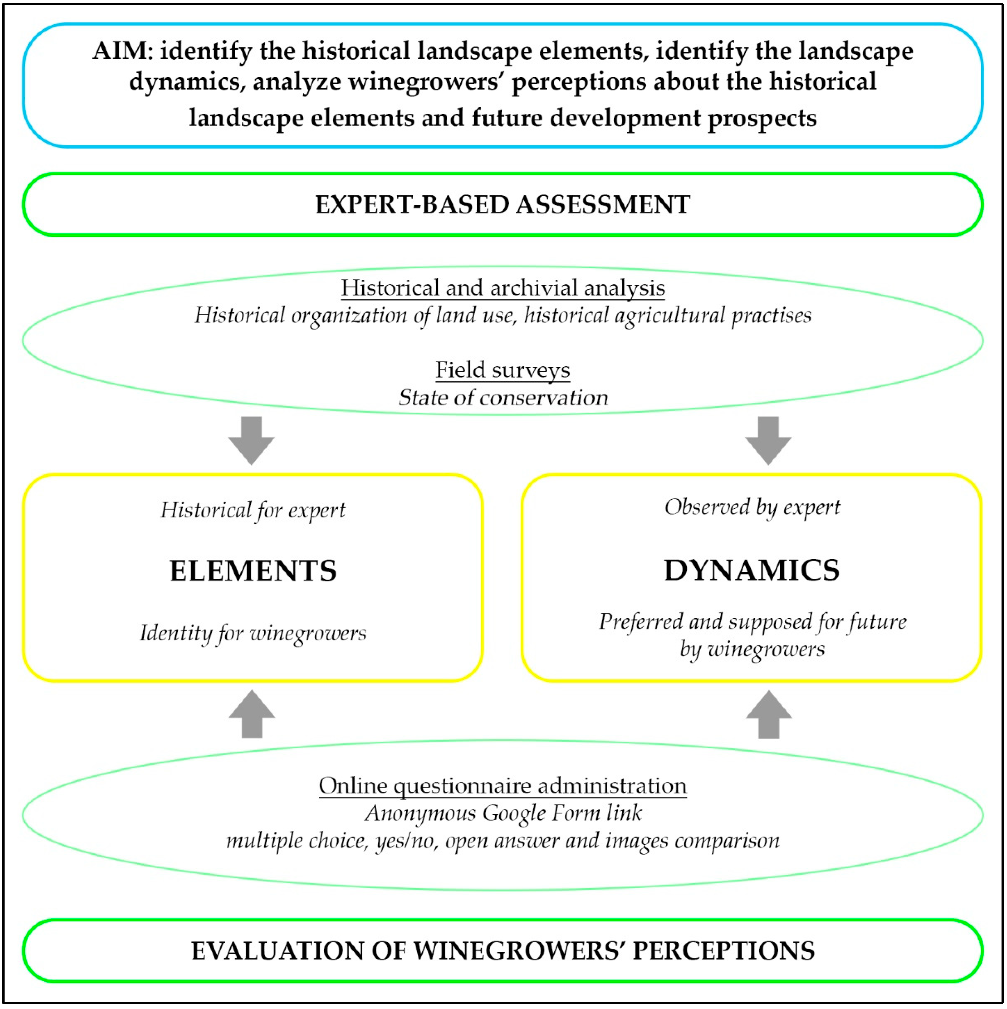
2.1. Methodological Framework
2.2. Expert-Based Assessment
2.3. Evaluation of Winegrowers’ Perceptions
- I.
- General information (questions 1–7).
- II.
- Farm characteristics (questions 8–20).
- III.
- Product characteristics (questions 21–23).
- IV.
- Landscape perception (questions 24–31).
- V.
- Future development prospects (questions 32–34).
3. Results
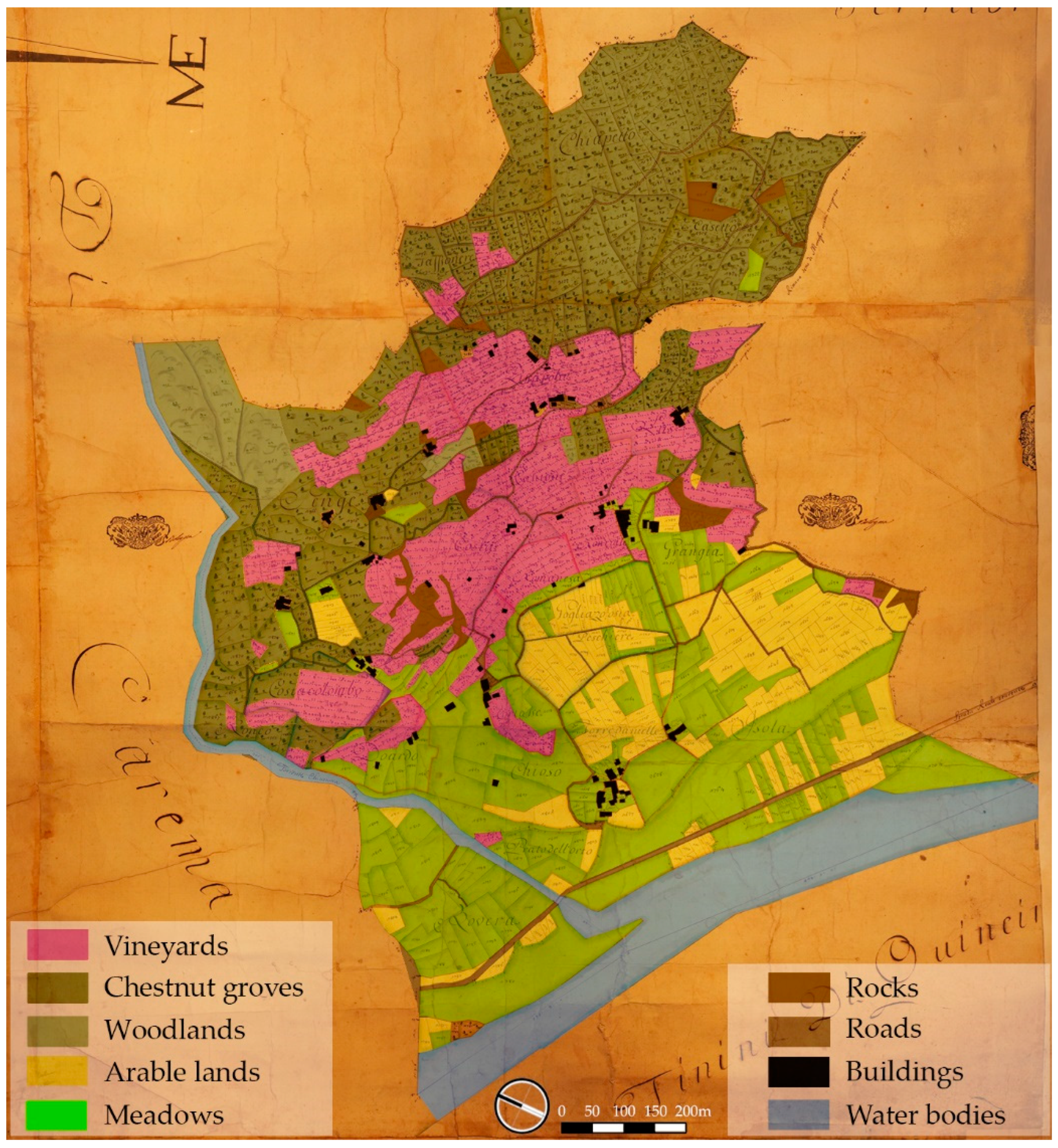
3.1. Expert-Based Assessment
3.2. Evaluation of Winegrowers’ Perceptions
4. Discussion
5. Conclusions
Author Contributions
Funding
Institutional Review Board Statement
Informed Consent Statement
Data Availability Statement
Acknowledgments
Conflicts of Interest
References
- Pereira, E.; Queiroz, C.; Pereira, H.M.; Vicente, L. Ecosystem services and human well-being: A participatory study in a mountain community in Portugal. Ecol. Soc. 2005, 10, 14. [Google Scholar] [CrossRef]
- Brunori, E.; Salvati, L.; Antogiovanni, A.; Biasi, R. Worrying about ‘vertical landscapes’: Terraced olive groves and ecosystem services in marginal land in central Italy. Sustainability 2018, 10, 1164. [Google Scholar] [CrossRef] [Green Version]
- Ghersi, A.; Ghiglione, G. Paesaggi Terrazzati. I Muretti a Secco Nella Tradizione Rurale Ligure; Edizioni Il Pivere: Gavi, Italy, 2012; pp. 68–81. ISBN 978-88-96348-086. [Google Scholar]
- de Madariaga, C.J. Dry stone constructions–intangible cultural heritage and sustainable environment. J. Cult. Herit. Manag. Sustain. Dev. 2021, 11, 614–626. [Google Scholar] [CrossRef]
- Stanchi, S.; Freppaz, M.; Agnelli, A.; Reinsch, T.; Zanini, E. Properties, best management practices and conservation of terraced soils in Southern Europe (from Mediterranean areas to the Alps): A review. Quat. Int. 2012, 265, 90–100. [Google Scholar] [CrossRef] [Green Version]
- Freppaz, M.; Agnelli, A.; Drusi, B.; Stanchi, S.; Galliani, C.; Revel Chion, V.; Zanini, E. Soil Quality and Fertility: Studies in the Valle d’Aosta; Marsilio Editori: Venezia, Italy, 2008; pp. 37–39. [Google Scholar]
- Pijl, A.; Wang, W.; Straffelini, E.; Tarolli, P. Soil and water conservation in terraced and non-terraced cultivations: An extensive comparison of 50 vineyards. Land Degrad. Dev. 2022, 33, 596–610. [Google Scholar] [CrossRef]
- Meliho, M.; Khattabi, A.; Nouira, A.; Orlando, C.A. Role of Agricultural Terraces in Flood and Soil Erosion Risks Control in the High Atlas Mountains of Morocco. Earth 2021, 2, 746–763. [Google Scholar] [CrossRef]
- Chen, D.; Wei, W.; Chen, L. Effects of terracing practices on water erosion control in China: A meta-analysis. Earth-Sci. Rev. 2017, 173, 109–121. [Google Scholar] [CrossRef]
- Arnaez, J.; Lasanta, T.; Errea, M.; Ortigosa, L. Land abandonment, landscape evolution, and soil erosion in a Spanish Mediterranean mountain region: The case of Camero Viejo. Land Degrad. Dev. 2011, 22, 537–550. [Google Scholar] [CrossRef]
- Corinto, G.L.; Pioletti, A.M. Viticulture and Landscape in the Italian Northwestern Alpine Region. Geogr. Noteb. 2019, 2, 53–67. [Google Scholar] [CrossRef] [Green Version]
- Italian Ministry of Agricultural, Food and Forestry Policies—Decree nr. 6899—30 June 2020. Available online: https://www.politicheagricole.it/flex/cm/pages/ServeBLOB.php/L/IT/IDPagina/15621 (accessed on 22 March 2022).
- Benayas, J.R.; Martins, A.; Nicolau, J.M.; Schulz, J.J. Abandonment of agricultural land: An overview of drivers and consequences. CAB Rev. Perspect. Agric. Vet. Sci. Nutr. Nat. Resour. 2007, 2, 1–14. [Google Scholar] [CrossRef] [Green Version]
- Tarolli, P.; Preti, F.; Romano, N. Terraced landscapes: From an old best practice to a potential hazard for soil degradation due to land abandonment. Anthropocene 2014, 6, 10–25. [Google Scholar] [CrossRef]
- Agnoletti, M.; Errico, A.; Santoro, A.; Dani, A.; Preti, F. Terraced landscapes and hydrogeological risk. Effects of land abandonment in Cinque Terre (Italy) during severe rainfall events. Sustainability 2019, 11, 235. [Google Scholar] [CrossRef] [Green Version]
- Modica, G.; Praticò, S.; Di Fazio, S. Abandonment of traditional terraced landscape: A change detection approach (a case study in Costa Viola, Calabria, Italy). Land Degrad. Dev. 2017, 28, 2608–2622. [Google Scholar] [CrossRef]
- Gravagnuolo, A.; Varotto, M. Terraced Landscapes Regeneration in the Perspective of the Circular Economy. Sustainability 2021, 13, 4347. [Google Scholar] [CrossRef]
- Tarolli, P.; Straffelini, E. Agriculture in hilly and mountainous landscapes: Threats, monitoring and sustainable management. Geogr. Sustain. 2020, 1, 70–76. [Google Scholar] [CrossRef]
- Scheurer, T.; Agnoletti, M.; Bürgi, M.; Hribar, M.Š.; Urbanc, M. Exploring alpine landscapes as potential sites of the Globally Important Agricultural Heritage Systems (GIAHS) Programme. Mt. Res. Dev. 2018, 38, 172–174. [Google Scholar] [CrossRef] [Green Version]
- Globally Important Agricultural Heritage Systems. Available online: https://www.fao.org/giahs/giahsaroundtheworld/en/ (accessed on 25 March 2022).
- Blondel, J. The ‘design’of Mediterranean landscapes: A millennial story of humans and ecological systems during the historic period. Hum. Ecol. 2006, 34, 713–729. [Google Scholar] [CrossRef]
- Qiu, Z.; Chen, B.; Takemoto, K. Conservation of terraced paddy fields engaged with multiple stakeholders: The case of the Noto GIAHS site in Japan. Paddy Water Environ. 2014, 12, 275–283. [Google Scholar] [CrossRef]
- Yang, L.; Liu, M.; Lun, F.; Min, Q.; Zhang, C.; Li, H. Livelihood assets and strategies among rural households: Comparative analysis of rice and dryland terrace systems in China. Sustainability 2018, 10, 2525. [Google Scholar] [CrossRef] [Green Version]
- Nan, M.; Lun, Y.; Qingwen, M.; Keyu, B.; Wenhua, L. The significance of traditional culture for agricultural biodiversity—Experiences from GIAHS. J. Resour. Ecol. 2021, 12, 453–461. [Google Scholar] [CrossRef]
- Zhang, Y.; Min, Q.; Zhang, C.; He, L.; Zhang, S.; Yang, L.; Tian, M.; Xiong, Y. Traditional culture as an important power for maintaining agricultural landscapes in cultural heritage sites: A case study of the Hani terraces. J. Cult. Herit. 2017, 25, 170–179. [Google Scholar] [CrossRef]
- Fusco Girard, L.; Gravagnuolo, A.; Rosa, F.D. The Multidimensional Benefits of Terraced Landscape Regeneration: An Economic Perspective and Beyond. In World Terraced Landscapes: History, Environment, Quality of Life; Springer: Berlin/Heidelberg, Germany, 2019; pp. 273–293. [Google Scholar]
- Zoumides, C.; Bruggeman, A.; Giannakis, E.; Camera, C.; Djuma, H.; Eliades, M.; Charalambous, K. Community-based rehabilitation of mountain terraces in Cyprus. Land Degrad. Dev. 2017, 28, 95–105. [Google Scholar] [CrossRef]
- Špulerová, J.; Dobrovodská, M.; Lieskovský, J.; Bača, A.; Halabuk, A.; Kohút, F.; Mojses, M.; Kenderessy, P.; Piscová, V.; Barančok, P. Inventory and classification of historical structures of the agricultural landscape in Slovakia. Ekológia 2011, 30, 157–170. [Google Scholar] [CrossRef]
- Agnoletti, M.; Santoro, A. The Italian National Register of Historical Rural Landscapes. In Cultural Heritage—Possibilities for Land-Centered Societal Development; Springer: Berlin/Heidelberg, Germany, 2022; pp. 15–34. [Google Scholar]
- Rete Rurale Nazionale—National Register of Historical Rural Landscapes. Available online: https://www.reterurale.it/registropaesaggi (accessed on 22 March 2022).
- Bastian, O.; Walz, U.; Decker, A. Historical landscape elements: Part of our cultural heritage—A methodological study from Saxony. In The Carpathians: Integrating Nature and Society towards Sustainability; Springer: Berlin/Heidelberg, Germany, 2013; pp. 441–459. [Google Scholar]
- Capolupo, A.; Kooistra, L.; Boccia, L. A novel approach for detecting agricultural terraced landscapes from historical and contemporaneous photogrammetric aerial photos. Int. J. Appl. Earth Obs. Geoinf. 2018, 73, 800–810. [Google Scholar] [CrossRef]
- Mojses, M.; Petrovič, F. Land use changes of historical structures in the agricultural landscape at the local level—Hriňová case study. Ekológia 2013, 32, 1–12. [Google Scholar] [CrossRef] [Green Version]
- Heider, K.; Rodriguez Lopez, J.M.; Balbo, A.L.; Scheffran, J. The state of agricultural landscapes in the Mediterranean: Smallholder agriculture and land abandonment in terraced landscapes of the Ricote Valley, southeast Spain. Reg. Environ. Chang. 2021, 21, 23. [Google Scholar] [CrossRef]
- Gullino, P.; Larcher, F. Integrity in UNESCO World Heritage Sites. A comparative study for rural landscapes. J. Cult. Herit. 2013, 14, 389–395. [Google Scholar] [CrossRef]
- Zhu, G.; Li, X.; Zhang, Y. Multi-Stakeholder Involvement Mechanism in Tourism Management for Maintaining Terraced Landscape in Important Agricultural Heritage Systems (IAHS) Sites: A Case Study of Dazhai Village in Longji Terraces, China. Land 2021, 10, 1146. [Google Scholar] [CrossRef]
- Zhang, Y.; Min, Q.; Li, H.; He, L.; Zhang, C.; Yang, L. A conservation approach of globally important agricultural heritage systems (GIAHS): Improving traditional agricultural patterns and promoting scale-production. Sustainability 2017, 9, 295. [Google Scholar] [CrossRef] [Green Version]
- Gullino, P.; Devecchi, M.; Larcher, F. How can different stakeholders contribute to rural landscape planning policy? The case study of Pralormo municipality (Italy). J. Rural Stud. 2018, 57, 99–109. [Google Scholar] [CrossRef]
- Cicinelli, E.; Caneva, G.; Savo, V. A review on management strategies of the terraced agricultural systems and conservation actions to maintain cultural landscapes around the Mediterranean Area. Sustainability 2021, 13, 4475. [Google Scholar] [CrossRef]
- Gianotti, F.; Forno, M.G.; Ajassa, R.; Cámara, F.; Costa, E.; Ferrando, S.; Giardino, M.; Lucchesi, S.; Motta, L.; Motta, M. The Ivrea Morainic Amphitheatre as a well preserved record of the Quaternary climate variability (PROGEO-Piemonte Project, NW Italy). In Engineering Geology for Society and Territory; Springer: Berlin/Heidelberg, Germany, 2015; Volume 8, pp. 235–238. [Google Scholar]
- Piedmont’s Regional Landscape Plan. Available online: https://www.regione.piemonte.it/web/temi/ambiente-territorio/paesaggio/piano-paesaggistico-regionale-ppr (accessed on 10 March 2022).
- UNESCO—Intangible Cultural Heritage. Available online: https://ich.unesco.org/en/RL/art-of-dry-stone-walling-knowledge-and-techniques-01393 (accessed on 10 March 2022).
- Istituto Nazionale di Statistica—ISTAT. Available online: https://www.istat.it (accessed on 10 May 2022).
- Borri, I.; Trione, S. L’Agricoltura nel Piemonte in Cifre 2021. Consiglio per la Ricerca in Agricoltura e l’Analisi Dell’economia Agraria—CREA, 2021; ISBN 9788833851211. Available online: https://www.crea.gov.it/documents/68457/0/PIEMONTE_cifre_21_DEF_WEB.pdf/2d0be4e2-0a46-0edd-f6ce-7c6a16e20e94?t=1620376477347 (accessed on 12 March 2022).
- Data Warehouse and Open Data Piedmont Region. Available online: https://servizi.regione.piemonte.it/catalogo/anagrafe-agricola-data-warehouse (accessed on 12 March 2022).
- Scazzosi, L. Reading and assessing the landscape as cultural and historical heritage. Landsc. Res. 2004, 29, 335–355. [Google Scholar] [CrossRef]
- Council of Europe Landscape Convention. Available online: https://www.coe.int/en/web/landscape (accessed on 22 March 2022).
- Antrop, M.; Rogge, E. Evaluation of the process of integration in a transdisciplinary landscape study in the Pajottenland (Flanders, Belgium). Landsc. Urban Plan. 2006, 77, 382–392. [Google Scholar] [CrossRef]
- Butler, A.; Berglund, U. Landscape character assessment as an approach to understanding public interests within the European landscape convention. Landsc. Res. 2014, 39, 219–236. [Google Scholar] [CrossRef] [Green Version]
- Slámová, M.; Jančura, P.; Daniš, D. Methods of historical landscape structures identification and implementation into landscape studies. Ekológia 2013, 32, 267–276. [Google Scholar] [CrossRef] [Green Version]
- Supuka, J.; Verešová, M.; Šinka, K. Development of vineyards landscape structure with regard to historical and cultural values. Ekológia 2011, 30, 229–238. [Google Scholar] [CrossRef]
- Femenia-Ribera, C.; Mora-Navarro, G.; Pérez, L.J.S. Evaluating the use of old cadastral maps. Land Use Policy 2022, 114, 105984. [Google Scholar] [CrossRef]
- Bayr, U. Quantifying historical landscape change with repeat photography: An accuracy assessment of geospatial data obtained through monoplotting. Int. J. Geogr. Inf. Sci. 2021, 35, 2026–2046. [Google Scholar] [CrossRef]
- Tesfamariam, Z.; Nyssen, J.; Poesen, J.; Ghebreyohannes, T.; Tafere, K.; Zenebe, A.; Deckers, S.; Van Eetvelde, V. Landscape research in Ethiopia: Misunderstood or lost synergy? Rangel. J. 2019, 41, 109–124. [Google Scholar] [CrossRef]
- Arnés García, M.; Yagüe, J.L.; de Nicolás, V.L.; Díaz-Puente, J.M. Characterization of globally important agricultural heritage systems (GIAHS) in Europe. Sustainability 2020, 12, 1611. [Google Scholar] [CrossRef] [Green Version]
- Fuller, A.M.; Min, Q.; Jiao, W.; Bai, Y. Globally Important Agricultural Heritage Systems (GIAHS) of China: The challenge of complexity in research. Ecosyst. Health Sustain. 2015, 1, 1–10. [Google Scholar] [CrossRef]
- Stabbetorp, O.E.; Sollund, M.-L.B.; Brendalsmo, J.; Norderhaug, A. Layers of the past: A theory and method for historical landscape analysis. Landsc. Res. 2007, 32, 463–479. [Google Scholar] [CrossRef]
- Roth, M. Validating the use of Internet survey techniques in visual landscape assessment—An empirical study from Germany. Landsc. Urban Plan. 2006, 78, 179–192. [Google Scholar] [CrossRef]
- Larcher, F.; Pomatto, E.; Battisti, L.; Gullino, P.; Devecchi, M. Perceptions of urban green areas during the social distancing period for COVID-19 containment in Italy. Horticulturae 2021, 7, 55. [Google Scholar] [CrossRef]
- Santoro, A.; Venturi, M.; Agnoletti, M. Landscape perception and public participation for the conservation and valorization of cultural landscapes: The case of the Cinque Terre and Porto Venere UNESCO site. Land 2021, 10, 93. [Google Scholar] [CrossRef]
- Tempesta, T. The perception of agrarian historical landscapes: A study of the Veneto plain in Italy. Landsc. Urban Plan. 2010, 97, 258–272. [Google Scholar] [CrossRef]
- Nederhof, A.J. Methods of coping with social desirability bias: A review. Eur. J. Soc. Psychol. 1985, 15, 263–280. [Google Scholar] [CrossRef]
- Barsimi, M. Carema Terra di Vino e di Emozioni; Hever Edizioni: Ivrea, Italy, 2013; ISBN 88-96308-21-9. [Google Scholar]
- Bonardi, L.; Varotto, M. Paesaggi Terrazzati d’Italia. Eredità Storiche e Nuove Prospettive; FrancoAngeli: Milano, Italy, 2016; ISBN 978-88-917-4343-5. [Google Scholar]
- Aimar, F.; Gullino, P.; Devecchi, M. Towards reconstructing rural landscapes: A case study of Italian Mongardino. J. Rural Stud. 2021, 88, 446–461. [Google Scholar] [CrossRef]
- Mazzarino, S. Il mercato dei vini da uve “Nebbiolo”. In Quaderni di Scienze Viticole ed Enologiche Dell’università di Torino; University of Turin: Torino, Italy, 2006; Volume 28, pp. 207–222. [Google Scholar]
- Forconi, V.; Guidi, S.; Bianco, P.M. Frutti Dimenticati e Biodiversità Recuperata. Il Germoplasma Frutticolo e Viticolo delle Agricolture Tradizionali Italiane. Casi Studio: Piemonte e Sardegna; ISPRA: Roma, Italy, 2015; Volume 7, pp. 59–60. ISBN 978-88-448-0708-5. [Google Scholar]
- Sakellariou, M.; Psiloglou, B.E.; Giannakopoulos, C.; Mylona, P.V. Integration of Abandoned Lands in Sustainable Agriculture: The Case of Terraced Landscape Re-Cultivation in Mediterranean Island Conditions. Land 2021, 10, 457. [Google Scholar] [CrossRef]
- Estacio, I.; Basu, M.; Sianipar, C.P.; Onitsuka, K.; Hoshino, S. Dynamics of land cover transitions and agricultural abandonment in a mountainous agricultural landscape: Case of Ifugao rice terraces, Philippines. Landsc. Urban Plan. 2022, 222, 104394. [Google Scholar] [CrossRef]
- Tortora, A.; Statuto, D.; Picuno, P. Rural landscape planning through spatial modelling and image processing of historical maps. Land Use Policy 2015, 42, 71–82. [Google Scholar] [CrossRef]
- Petanidou, T.; Kizos, T.; Soulakellis, N. Socioeconomic dimensions of changes in the agricultural landscape of the Mediterranean basin: A case study of the abandonment of cultivation terraces on Nisyros Island, Greece. Environ. Manag. 2008, 41, 250–266. [Google Scholar] [CrossRef] [PubMed]
- Borrello, M.; Cecchini, L.; Vecchio, R.; Caracciolo, F.; Cembalo, L.; Torquati, B. Agricultural landscape certification as a market-driven tool to reward the provisioning of cultural ecosystem services. Ecol. Econ. 2022, 193, 107286. [Google Scholar] [CrossRef]
- Gao, X.; Roder, G.; Jiao, Y.; Ding, Y.; Liu, Z.; Tarolli, P. Farmers’ landslide risk perceptions and willingness for restoration and conservation of world heritage site of Honghe Hani Rice Terraces, China. Landslides 2020, 17, 1915–1924. [Google Scholar] [CrossRef] [Green Version]
- Hara, Y.; Oki, S.; Uchiyama, Y.; Ito, K.; Tani, Y.; Naito, A.; Sampei, Y. Plant Diversity in the Dynamic Mosaic Landscape of an Agricultural Heritage System: The Minabe-Tanabe Ume System. Land 2021, 10, 559. [Google Scholar] [CrossRef]
- Veldhuizen, L.J.; Giller, K.E.; Oosterveer, P.; Brouwer, I.D.; Janssen, S.; van Zanten, H.H.; Slingerland, M. The Missing Middle: Connected action on agriculture and nutrition across global, national and local levels to achieve Sustainable Development Goal 2. Glob. Food Secur. 2020, 24, 100336. [Google Scholar] [CrossRef]
- Agenda 2030—United Nations Regional Information Centre. Available online: https://unric.org/it/agenda-2030/ (accessed on 10 March 2022).


| Inhabitants (no.) | Aging Index (no. of Inhabitants >64 Years Old Per 100 Inhabitants <15 Years Old) | Housing Density (Inhabitants/km2) | |
|---|---|---|---|
| Borgofranco di Ivrea | 3590 | 234 | 267 |
| Carema | 739 | 233 | 72 |
| Nomaglio | 291 | 273 | 95 |
| Settimo Vittone | 1513 | 245 | 65 |
| Piedmont region | 4,274,945 | 215 | 168 |
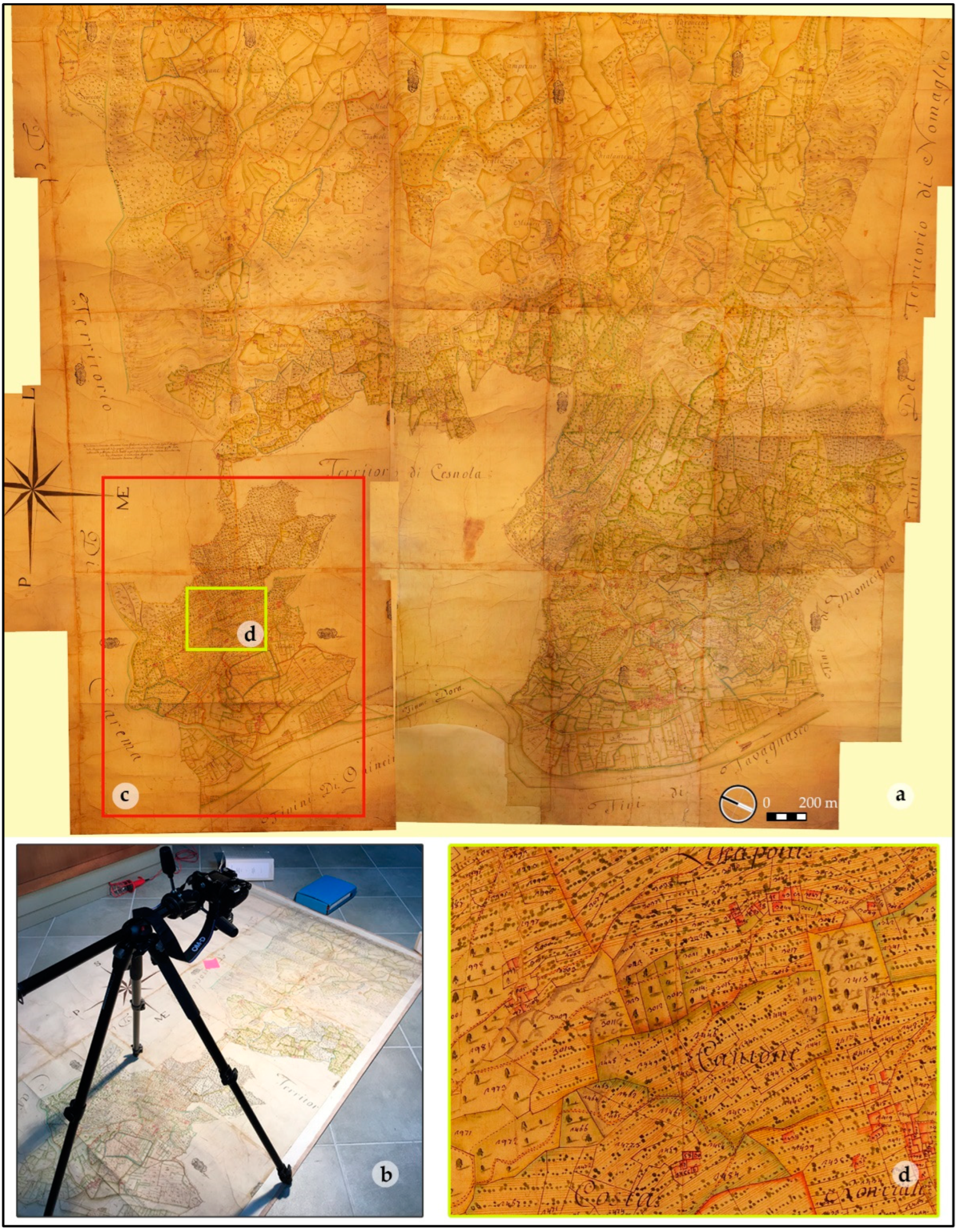
| Archive Name and Location | Year | Original Name | Documentation |
|---|---|---|---|
| Historical archive of Carema municipality | 1651 | Lettere per Inibizione delle Vendemmie Istanti li Agenti della Comunità di Carema | Written letter |
| Historical archive of Carema municipality | 1749 | Cattastro della Molto Magnifica Comunità di Carema Provincia di Ivrea | Cadastral map |
| Historical archive of Settimo Vittone municipality | 1789 | Catastro della Molto Magnifica Comunità di Settovittone | Cadastral map of Savoy family |
| Historical archive of Carema municipality | 1802 | Libro Campagnolo Figurato di Tutto il Territorio di Carema | Cadastral map |
| Historical archive of Carema municipality | 1802 | Catasto del Commune di Carema | Cadastral map |
| Costantino Nigra Civic Library of Ivrea | 1833 | Saggio intorno alle viti ed ai vini della Provincia d’Ivrea e della Valle d’Aosta del Medico Lorenzo Francesco Gatta | Monograph |
| Costantino Nigra Civic Library of Ivrea | 1910 | I Vigneti ed il Vino di Carema. Indagini e Considerazioni del Direttore Prof. Dott. G. Chiej-Gamacchio | Monograph |
| Costantino Nigra Civic Library of Ivrea | 1986 | I Balmetti di Borgofranco di Ivrea | Monograph |
| Questions | Answer Choices |
|---|---|
| I. General Information | |
| 1. Do you manage terraced vineyards? | Yes, professional activity; yes, non-professional activity; no |
| 2. Age | (Years) |
| 3. Sex (not mandatory) | Male, female |
| 4. Education | Primary school, secondary school, high school, university degree |
| 5. Among your family, is there anyone who wants to continue the viticultural activity? | Yes, no, do not know |
| 6. Do you think you have a role in maintaining the terraced landscape? | Yes, no |
| 7. What are the identity elements in the landscape? | (Open) |
| II. Farm’s characteristics | |
| 8. How many family members besides you work on the farm? | (Number) |
| 9. Do you have permanent and/or seasonal employees? | (Number) |
| 10. Are all the vineyards merged? | Yes, no |
| 11. Age of oldest vineyards | (Number of years) |
| 12. Age of youngest vineyards | (Number of years) |
| 13. Total surface area of terraced vineyards | (m2) |
| 14. Which vine varieties are present? | Nebbiolo Picotendro, Nebbiolo Prugnet, other Nebbiolo, Barbera, Freisa, Bonarda, Neretto, Croatina, Erbaluce, Chardonnay, other |
| 15. What is the main vine-breeding system? | Traditional high pergola (warp with wooden poles), modified high pergola; espalier, other |
| 16. Are stone columns (pilun) present? | Yes, no |
| 17. In addition to terraced vineyards, do you have any of the following categories? | Meadow/pasture, arable land and cereals, olive groves, chestnut groves, sheep and goats, bovines, no, other |
| 18. What is the state of conservation of dry stone walls? | Intact, partially damaged, completely damaged |
| 19. What type of agriculture do you practice? | Conventional, integrated, biological, other |
| 20. Do you have problems managing terraced vineyards? If so, which ones? | (Open) |
| III. Product characteristics | |
| 21. Do you produce DOC wines? | (List of DOC wines produced in the area), do not produce DOC wines, give grapes to other cellars |
| 22. What are the distribution channels for produced wine? | Direct sale on the farm, hotels/restaurants/cafes, big organized distribution (supermarkets), solidarity buying groups, online, give grapes to other cellars, not sold (family use), other |
| 23. In which geographical area is the wine produced sold? | Piedmont/Aosta Valley, Northern Italy, Central and/or Southern Italy, Europe, non-EU countries, give grapes to other cellars, not sold (family use) |
| IV. Landscape perception | |
| 24. Do you think the terraced landscape should be considered an added value to the wine produced there? | Yes, no |
| 25. Do you think the terraced landscape could also be of interest from a tourist point of view? | Yes, no |
| 26. Do you think dry stone walls are identity elements of the landscape? | Yes, no |
| 27. Do you think stone columns (pilun) are identity elements of the landscape? | Yes, no |
| 28. Do you think the pergola vine-breeding technique is an identity element of the landscape? | Yes, no |
| 29. Do you think espalier vine-breeding technique is an identity element of the landscape? | Yes, no |
| 30. Do you think vines are an identity element of the landscape? | Yes, no |
| 31. Do you think olive groves are an identity element of the landscape? | Yes, no |
| V. Future development prospects | |
| 32. Which future do you think is more possible for your terraced vineyards? | They will continue to be managed in the traditional way (pergola), the traditional vine-breeding technique will be modified (espalier), they will be converted to other crops (olive groves), they will no longer be cultivated but will be managed (mowed), they will be completely abandoned and invaded by woods |
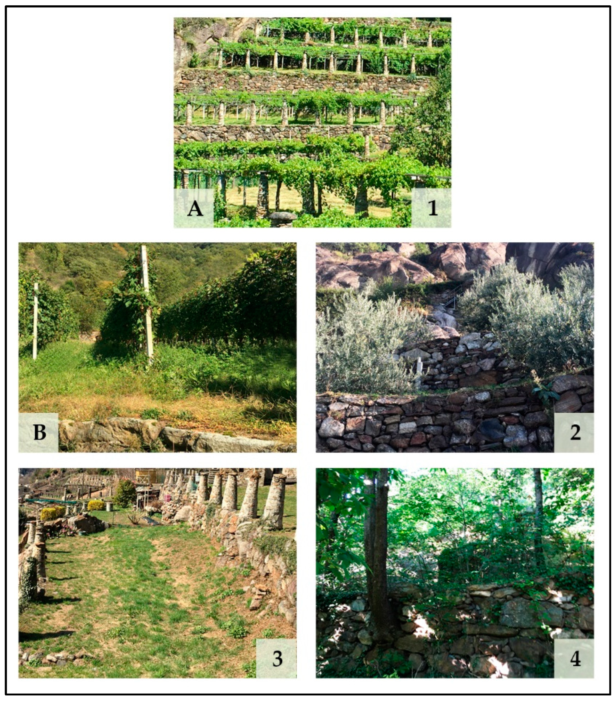
| 33. Between the two future prospects proposed in the following pairs of images, which do you like more? (indicate an answer for each pair) | A-B; 1-2; 1-3; 1-4; 2-3; 2-4; 3-4 * |
| 34. Between the two future prospects proposed in the following pairs of images, which do you think is more likely in the future? (indicate an answer for each pair) | A-B; 1-2; 1-3; 1-4; 2-3; 2-4; 3-4 * |
| Age Range (2) (%) | Sex (3) (%) | Education (4) (%) | |||||||
|---|---|---|---|---|---|---|---|---|---|
| 18–30 | 31–45 | 46–60 | >60 | M | F | Primary School | Secondary School | High School | University Degree |
| 6 | 31 | 22 | 41 | 85.7 | 14.3 | 4 | 33 | 43 | 20 |
| How Many Family Members Besides You Work on the Farm? (8) (%) | Do you Have Permanent and/or Seasonal Employees? (9) (%) | |
|---|---|---|
| 0 | 49 | 89.8 |
| 1 | 26.53 | 8.16 |
| 2 | 12.24 | - |
| 3 | 10.2 | 2.04 |
| 4 | 2.04 | - |
| Do you Have Problems Managing Terraced Vineyards? If So, Which Ones? | |
|---|---|
| Reported Problem | Number of Citations |
| Terraces management | 12 |
| Accessibility | 11 |
| Poor mechanization | 7 |
| Difficulty with management | 5 |
| Water availability | 5 |
| Proximity to uncultivated lands | 2 |
| Too much time | 2 |
| Land pulverization | 2 |
| Management costs | 2 |
| Too much time for pergola management | 1 |
| Pilun management | 1 |
| What Are the Identity Elements in the Landscape? | |||
|---|---|---|---|
| Reported Element | Number of Citations | Reported Element | Number of Citations |
| Terraces | 31 | Pastures | 1 |
| Vineyards/viticulture | 19 | Woodlands | 1 |
| Pilun | 14 | Mixed agriculture | 1 |
| Pergolas | 13 | Uniqueness | 1 |
| Dry stone walls | 7 | Rocks | 1 |
| Chestnut groves | 6 | Fragility of terraces | 1 |
| Olive groves | 6 | Cows | 1 |
| Nebbiolo | 2 | Restaurants | 1 |
| Mule tracks | 2 | Cheeses | 1 |
| Architecture | 2 | Mountains | 1 |
| Meadows | 1 | People | 1 |
| Do You Think These Are Identity Elements of the Landscape? | ||
|---|---|---|
| Proposed Element | Yes (%) | No (%) |
| Dry stone walls (26) | 100 | 0 |
| Stone columns (pilun) (27) | 98 | 2 |
| Pergola vine-breeding technique (28) | 100 | 0 |
| Espalier vine-breeding technique (29) | 14.3 | 85.7 |
| Vines (30) | 98 | 2 |
| Olive groves (31) | 32.7 | 67.3 |
| Between the Two Future Prospects Proposed in the Following Pairs of images, Which Do You Like More? (Indicate an Answer for Each Pair) (%) | |||||
|---|---|---|---|---|---|
| A | B | 1 | 2 | 3 | 4 |
| 95.9 | 4.1 | - | - | - | - |
| - | - | 93.9 | 6.1 | - | - |
| - | - | 98 | - | 2 | - |
| - | - | 98 | - | - | 2 |
| - | - | - | 63.3 | 36.7 | - |
| - | - | - | 89.8 | - | 10.2 |
| - | - | - | - | 89.8 | 10.2 |
| Between the Two Future Prospects Proposed in the Following Pairs of Images, Which Do You Think Is More Likely in the Future? (Indicate an Answer for Each Pair) (%) | |||||
|---|---|---|---|---|---|
| A | B | 1 | 2 | 3 | 4 |
| 57.1 | 42.9 | - | - | - | - |
| - | - | 75.5 | 24.5 | - | - |
| - | - | 69.4 | - | 30.6 | - |
| - | - | 75.5 | - | - | 24.5 |
| - | - | - | 55.1 | 44.9 | - |
| - | - | - | 63.3 | - | 36.7 |
| - | - | - | - | 75.5 | 24.5 |
Publisher’s Note: MDPI stays neutral with regard to jurisdictional claims in published maps and institutional affiliations. |
© 2022 by the authors. Licensee MDPI, Basel, Switzerland. This article is an open access article distributed under the terms and conditions of the Creative Commons Attribution (CC BY) license (https://creativecommons.org/licenses/by/4.0/).
Share and Cite
Pomatto, E.; Devecchi, M.; Larcher, F. Coevolution between Terraced Landscapes and Rural Communities: An Integrated Approach Using Expert-Based Assessment and Evaluation of Winegrowers’ Perceptions (Northwest Piedmont, Italy). Sustainability 2022, 14, 8624. https://0-doi-org.brum.beds.ac.uk/10.3390/su14148624
Pomatto E, Devecchi M, Larcher F. Coevolution between Terraced Landscapes and Rural Communities: An Integrated Approach Using Expert-Based Assessment and Evaluation of Winegrowers’ Perceptions (Northwest Piedmont, Italy). Sustainability. 2022; 14(14):8624. https://0-doi-org.brum.beds.ac.uk/10.3390/su14148624
Chicago/Turabian StylePomatto, Enrico, Marco Devecchi, and Federica Larcher. 2022. "Coevolution between Terraced Landscapes and Rural Communities: An Integrated Approach Using Expert-Based Assessment and Evaluation of Winegrowers’ Perceptions (Northwest Piedmont, Italy)" Sustainability 14, no. 14: 8624. https://0-doi-org.brum.beds.ac.uk/10.3390/su14148624