Article

Conservation and Management of Agricultural Landscapes through Expert-Supported Participatory Processes: The “Declarations of Public Interest” in an Italian Province

1
Department of Architecture and Engineering, Faculty of Architecture and Design, Polis University, 12 Rruga Bylis, 1051 Tirana, Albania
2
Cavagnino Studio, Via Serafino Grassi 33, 14100 Asti, Italy
3
Department of Agricultural, Forest and Food Sciences, University of Turin, 2 Largo Paolo Braccini, 10095 Grugliasco, Italy
*
Author to whom correspondence should be addressed.
Sustainability 2022, 14(14), 8843; https://0-doi-org.brum.beds.ac.uk/10.3390/su14148843
Submission received: 19 June 2022 / Revised: 7 July 2022 / Accepted: 13 July 2022 / Published: 19 July 2022
(This article belongs to the Special Issue Sustainable Rural Landscape: Study, Planning, and Design)

Abstract

:
The adoption of the European Landscape Convention by the member states of the Council of Europe emphasized the importance of raising awareness of, promoting and educating local communities in, and fostering the activism of all European citizens in the process of transforming the European landscape. The work carried out by the Landscape Observatory for Montferrat and Astigiano was to raise awareness in local communities regarding landscape protection processes that those communities could steer, as required by the Code of the Cultural and Landscape Heritage of the Italian State (2004). Consequently, for the first time, a participatory model was established in the province of Asti and the Piedmont region in Italy to support the community-driven requests for a special protection decree for some targeted areas. In this paper, the process and novel multisource methodology used for the two pilot cases are reported, where the landscape values to be protected were identified through local community involvement. Supported by the Landscape Observatory and experts, the broad participation allowed their recognition of Public Interest. These recognitions are relevant because they rely on a shared perspective of populations for the self-management of their landscapes. They represent an operational model for other local communities in the Council of Europe countries.

1. Introduction

Participatory management approaches can be conceived as in flux, constantly being redefined as they integrate bottom-up contributions into a top-down and multilevel institutional framework. Greater community involvement in the management process [1] is essential for building effective resilience of territories, and this involvement should include place-based and specific approaches. The International Centre for the Study of the Preservation and Restoration of Cultural Property and the International Council on Monuments and Sites mentioned concepts such as people-centred approaches and living heritage [2,3] as core components of the comanagement and conservation of cultural heritage.
Although the role of communities and stakeholders has been discussed fairly often in the literature on UNESCO cultural landscapes and related community enhancement practices [4,5,6], the contribution of Declarations of Public Interest in the preservation management of the Italian landscape has been poorly addressed within the participation framework. Indeed, a survey carried out in Elsevier’s ScienceDirect in July 2021 did not find any matches in the fields of “Agricultural and Biological Sciences” or “Environmental Science”. Similarly, no results were found in the Taylor and Francis Online search engine in the search areas of “Geography” and “Museum and Heritage Studies” and the subcategory of the latter “Heritage Management and Conservation”. The Wiley Online Library seemed to confirm this research gap, as revealed by searches under the subjects “Environmental Studies” and “Geography”. Finally, the MDPI database showed no matches in articles from any MDPI-published journals, even failing to specify subjects and article types over a range from 1996 to 2021.
It has emerged, therefore, that many of these protection initiatives are top-down and/or expert led. Legislative Decree 3 April 2006, No. 152 assigned the regions, or the territorial bodies delegated by them, the technical–administrative fulfilments for the reclamation of contaminated sites (Sites of Regional Importance, or SIRs). Therefore, the perimeter of the mentioned sites of natural interest at the local level in the Piedmont region was proposed by the Piedmont region, for instance.
Similarly, Special Areas of Conservation (SACs) are protected areas in the traditional sense that were created with the 92/43 “Habitat” directive, implemented by Presidential Decree No. 357/97 and subsequently No. 120/03. Within six years, SCIs become SACs through designation by the Member States by virtue of a legal act. SPAs, on the other hand, are not protected areas in the traditional sense but are regulated by E.U. Directive 79/409 “Birds”, transposed into Italy by hunting law No. 157/92.
Finally, “… in Italy the first national parks were established during the twenty years of the Fascist regime, with little respect for the will of the people, reflecting the dirigisme of the time; and it should be noted, however, that top-down methods have been adopted even recently for the extensions of some of the existing national parks” [7].
In this context, only the designation of the mentioned World Heritage Site seems to be required by the communities as part of the bottom-up approach within the traditional top-down framework supported by expert assistance. Consequently, it is necessary to examine more closely bottom-up approaches to the conservation of natural areas, including Declarations of Public Interest.
In Piedmont, Italy, traditional conservation and management landscape models, including Sites of Regional Importance, Sites of Community Importance (i.e., Special Protection Areas and Special Areas of Conservation as parts of the European Union’s Natura 2000 Network), and nature parks and preserves, are related to their features. Moreover, Piedmont counts seven Wine Routes, which were established by a National Law (1999) and are regulated by Regional Laws (1999, 2008) and a Regional Government Decree (2021). Each of these protected areas of natural and palaeontological interest, with their specific degrees of cogency and protection, is state or region led and top-down. An intermediate level is represented by the recognition of eight Historic Rural Landscapes by the Ministry of Agriculture, Food, and Forestry in the Piedmont region. These are listed in the National Register of Rural Landscapes of Historical Interest, Agricultural Practices, and Traditional Knowledge, for which the rules for application can be consulted on the ministerial website. Successful recognition then allows the property to be nominated for FAO GIAS recognition. These processes are expert led or initiated based on decisions by municipal or regional stakeholders. Lastly, bottom-up initiatives within the top-down framework include one Food District (regulated by a Regional Law in 2019 and a Regional Council Resolution in 2020) and the PGI and Municipal Denomination (De.Co.) recognitions of particular crops (such as the lemon peach in the municipality of Asti, Piedmont).
Therefore, this article aimed to contribute to filling a gap in this research by presenting the possibility of a broader understanding of the participatory process in the integrated landscape management approach through the proactive contribution of the community in Italy. It sought to contribute to the international debate on the topic of self-mobilisation concerning lived landscape democracy in Europe [8], self- and codetermination in democracy related to landscape transformation [9,10], and how widening participation yields robust solutions [11]. A new methodological framework was purposely designed by experts with the support of the local Landscape Observatory and used to achieve these declarations in the province of Asti, Piedmont, Italy. The process and the related methodology used to prepare the application for these recognitions are reported in this paper for the first time. To this end, the study focused on two case studies to highlight their scope, procedural steps, and varying applicability depending on the context and heritage assets.

Research Aims

Declarations of Public Interest are the most relevant tool allowed by the Italian State in terms of community inclusion and collaborative management with regard to landscape management decision making. As they were novel once allowed in 2004, it was necessary to develop a methodology that could establish the stages of the process and permit other scholars to trigger similar initiatives at the international level.
Consequently, the purpose of this research was to respond to the need for greater inclusion of communities and their members in landscape asset stewardship. To that end, the authors propose an innovative model established in the province of Asti, Piedmont, Italy to preserve some landscape features over time thanks to Declarations of Public Interest. The relevance and innovativeness of this model lie in offering a procedure capable of channelling the spontaneous and collective will of a community to decide the asset to be protected without suggestions or a priori top-down decisions. Experts facilitate this process by drafting the necessary documentation and debating each procedural stage in open public assemblies and with local and regional authorities without directing the process. Therefore, their role is to accompany rather than guide the process.
With these aims, the paper demonstrated the effectiveness of the community-driven process for nominating specific landscapes for recognition of public interest and the contribution of the Landscape Observatory and experts in supporting and encouraging it. The authors propose an integrated methodology and scheme to support preliminary analyses for the application file using a qualitative approach through procedural steps.
Two case studies, of the municipalities of Isola Villa and Montafia (province of Asti, Piedmont, northwest Italy), are discussed in detail to make the process and methodology more understandable.
Moreover, within the scope of reinforcing the relevance of communities as attributes of the landscape, the role of public participation and community engagement in landscape decisions is debated, and different procedures regarding Declarations of Public Interest in other Italian regions are compared.

2. Materials and Methods

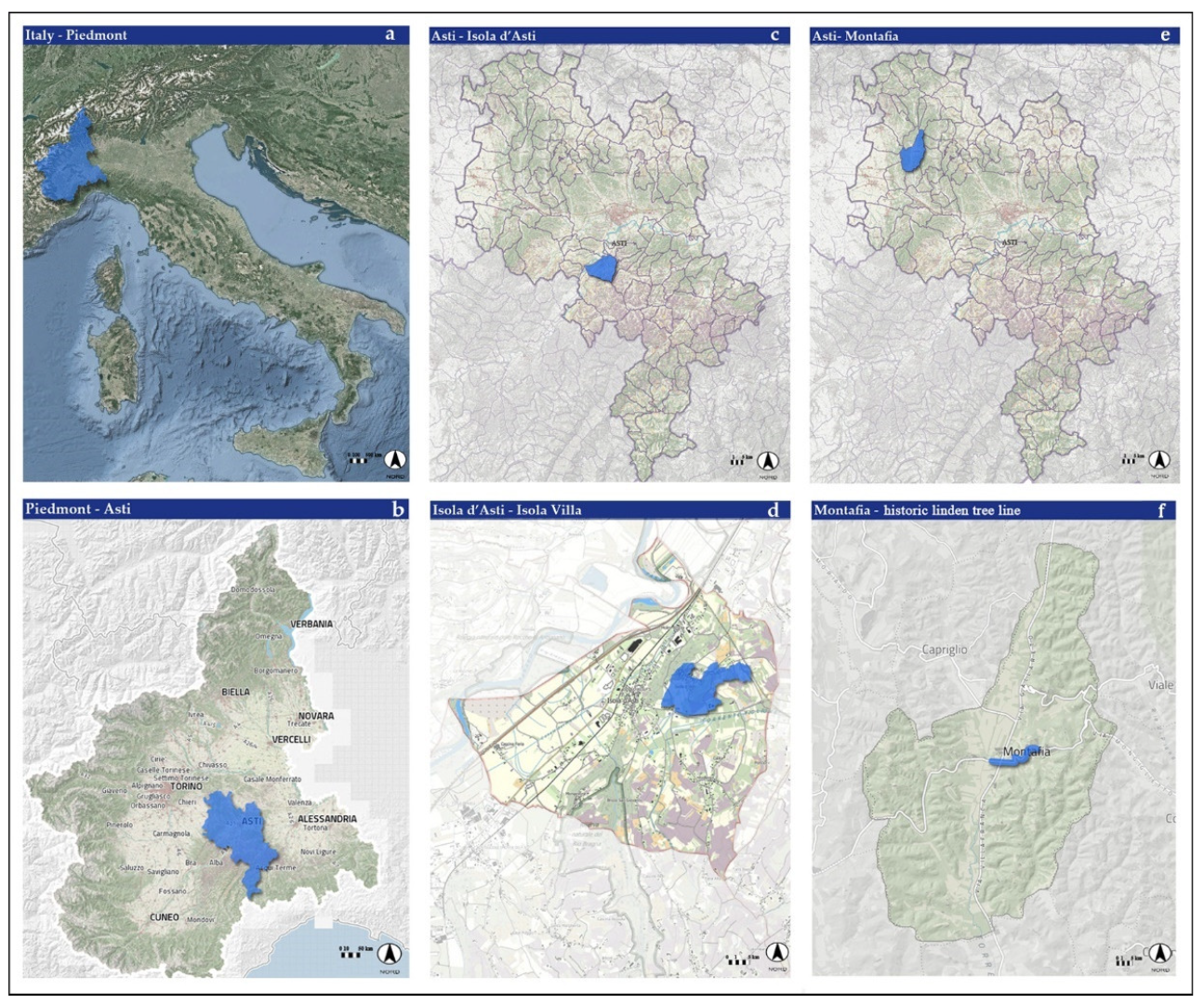
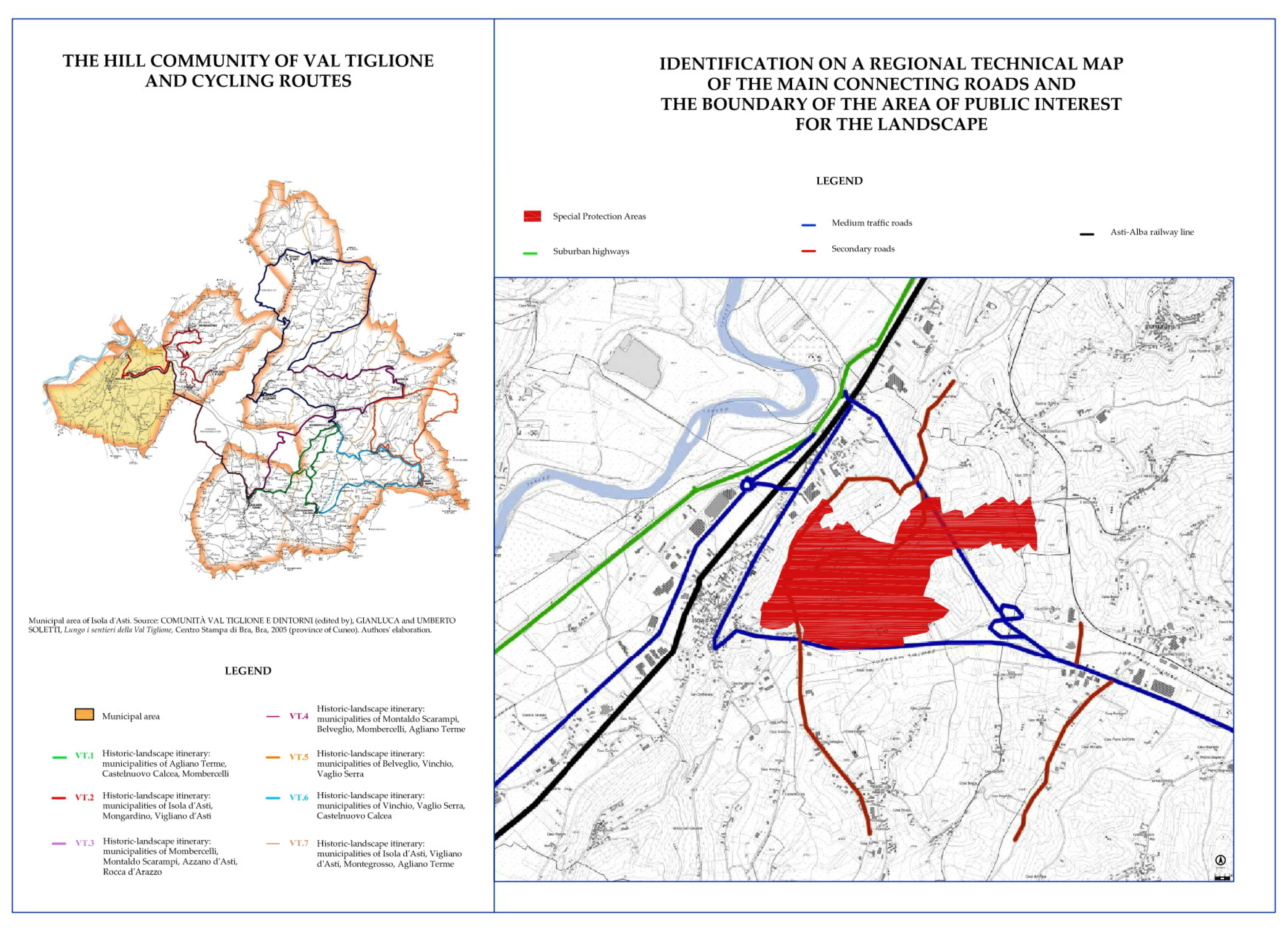
2.1. The Study Areas

The province of Asti (GPS coordinates: 44°54′2.8794″ N, 8°12′23.04″ E) is composed of 118 municipalities and has several remarkable natural features and elements (e.g., fluvial and lacustrine environments, hills and ravines, wooded areas), recognized by the multilevel governance of land use.
These natural features and elements are listed below:
  • 1 Site of Regional Importance (the acronym of which is SIR in Italian) [12];
  • 6 Sites of Community Importance (SCIs), including 1 Special Protection Area (SPA) and 5 Special Areas of Conservation (SACs); these are included in the European Union’s Natura 2000 Network [13];
  • 1 nature park and 6 nature preserves;
  • 32 out of 72 municipalities making up the buffer zone of the UNESCO site named the “Vineyard Landscape of Piedmont: Langhe-Roero and Monferrato” [14] are in the province of Asti and lie within its buffer zone A [14];
  • 9 out of 29 municipalities composing the serial property of the aforementioned World Heritage Site are located in the same province and fall under the Components “Nizza Monferrato and Barbera” (1390rev-004) [14] and “Canelli and Asti Spumante” (1390rev-005) [14].
The managing agencies are, on the one hand, the Asti Fossil Park Management Agency for the mentioned SCIs, nature park, and nature reserves, and, on the other hand, the Association for the Heritage of the Vineyard Landscapes of Langhe Roero and Montferrat for the UNESCO site.
In this context, the first case study of the ancient hamlet of Villa in the municipality of Isola d’Asti (GPS coordinates: 44°50′0.3372″ N, 8°11′15.4818″ E) is introduced. It is located in the hilly areas of Langhe and High Montferrat in the province of Asti (Piedmont, northwest Italy), the centre of which is 567 m from the boundary of Buffer Zone A of the “Vineyard Landscape of Piedmont: Langhe-Roero and Monferrato” [14] (Figure 1). It is a cultural landscape recognized by UNESCO as a World Heritage Site in 2014 under the reference 1390rev.
Regarding the social context, Isola d’Asti has a decreasing population of 1960 inhabitants [15] with a growing average age of 48.3 years [15], distributed over an area of 13.50 km2. The average income per capita was 14,285 EUR in 2016 [16]. In terms of spatial level, the area is composed of a combination of historical layers, resulting in many scenic vistas. An articulated system composed of farmsteads, roads, routes, and trails was already detectable in early nineteenth century historical documents and iconography and still persists today. This system represents one of the most distinctive elements of this wine-growing area in the Piedmont region regarding land use. In addition to the wooded areas, there are several traditional crops, such as square Asti pepper and native grape varieties, including Moscato (Muscat) and Barbera. Their persistence has been proven by documentary evidence dating back to the first half of the 18th century, as in the “Relazione Generale dell’Intendente d’Asti Giovan Battista Balduini di Santa Margherita sullo stato della Provincia 1750–1753” (“General Report of the Intendant of Asti Giovan Battista Balduini di Santa Margherita on the condition of the province 1750–1753”) reissued by the Società di Studi Astesi in 2010.
The second case study was the historic linden tree line that connects the local sulphur spring, also known as a sulphur fountain, to the village of Montafia (GPS coordinates: 44°59′13.8222″ N, 8°1′12.4824″ E) (Figure 1). This village is located in the hilly areas of Montferrat in the province of Asti, Piedmont, northwest Italy.
Concerning the social context, Montafia has a stable population of 927 inhabitants [15], lower than that of Isola d’Asti, with a growing average age of 50.8 years [15]. It is distributed over 14.50 km2, similarly to the other case study. The average income per capita was 15,416 EUR in 2016 [17], slightly higher than that of Isola d’Asti. The tree line plays an important role in the visual connection between the hamlet of Zolfo and Montafia, as previously mentioned. It was planted to commemorate the fallen of the First World War in 1926, following a proposal made by the Ministry of Public Education of the Kingdom of Italy in 1923. In circular No. 73 of Official Bulletin No. 52, dated 28 December 1922, each of the towns and villages in Italy was encouraged to create a Park or Avenue of Remembrance in memory of the victims of World War I. The tree-lined avenue of Montafia is therefore a broad avenue about two and a half kilometres long, the trees of which (Tilia × europaea, or British Isles) were planted by schoolchildren to pay tribute to the valour of soldiers killed in battle. With law No. 559, dated 21 March 1926, Minister Pietro Fedele declared the Parks and the Avenues of Remembrance as public monuments.

2.2. Methodological Framework

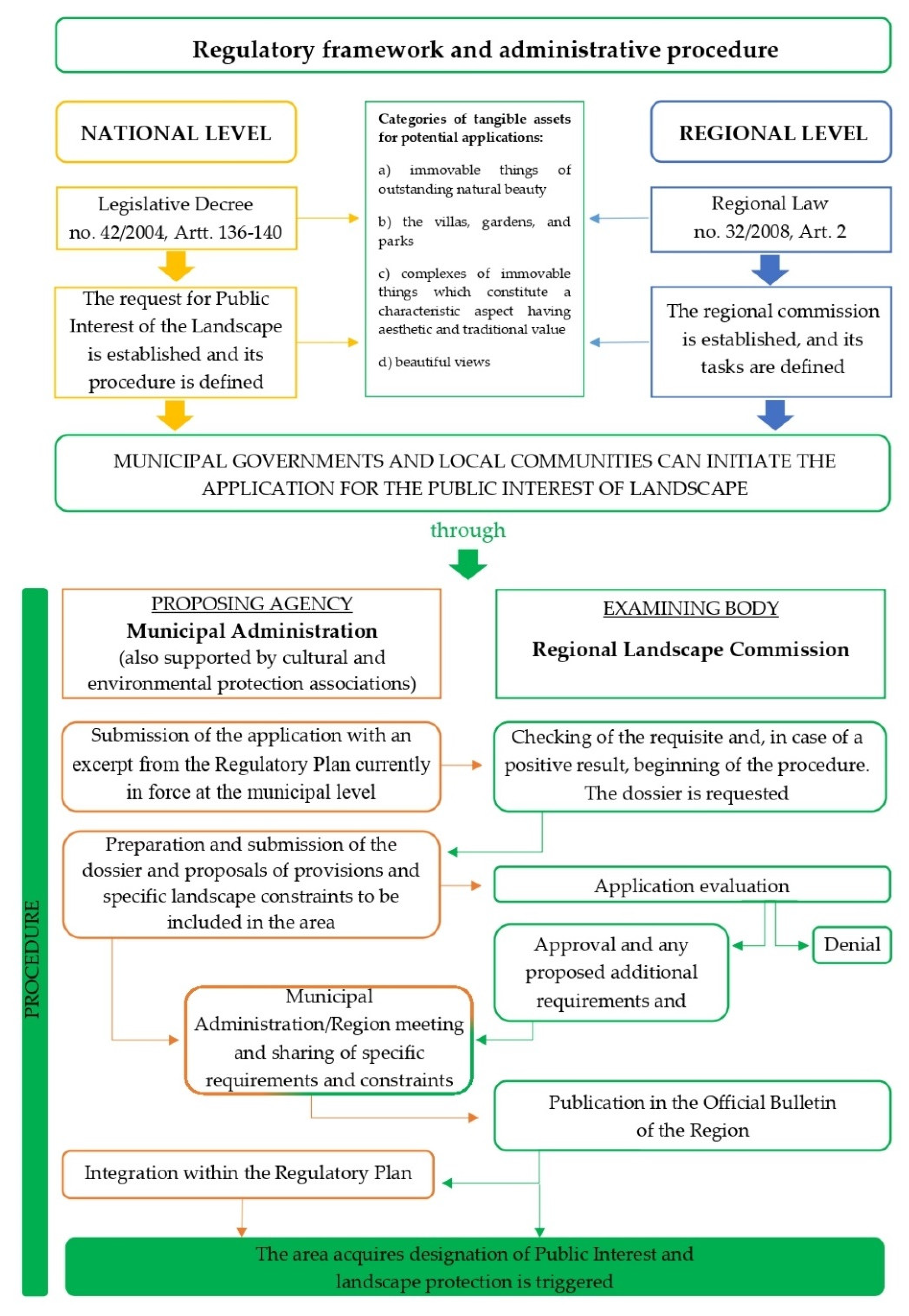
Procedural Steps and Regulatory Framework

The application process to mark a landscape as an area of public interest is part of a complex, multitiered regulatory framework for landscape protection, as shown in Figure 2.
In Italy, the Constitution of the Italian Republic referred to the need for landscape conservation in its Fundamental Principles. More specifically, it affirmed that “it [the Republic, A/N] safeguards natural landscape and the historical and artistic heritage of the nation” [18] (Art. 9). In addition, the Constitution of the Italian Republic recognized that “the State, regions, metropolitan cities, provinces, and municipalities shall promote the autonomous initiatives of citizens, both as individuals and as members of associations, relating to activities of general interest, on the basis of the principle of subsidiarity” [18] (Art. 118). Communities and associations calling to initiate public interest actions and procedures, including landscape protection, are thus welcome against this institutional backdrop. The following Legislative Decree No. 42 of 22 January 2004, known as the Code of the Cultural and Landscape Heritage of the Italian State, established the possibility of applying for recognition of Landscapes of Public Interest and regulated the procedure under Articles 136–140. Article 136, as last amended by Art. 2 of Legislative Decree No. 63 of 2008, also highlighted the categories of tangible assets for which applications can be made:
  • “Immovable things of outstanding natural beauty, geological singularity or historical memory, including monumental trees” [19] (Art. 136, para 1.a);
  • “The villas, gardens, and parks, … which stand out for their uncommon beauty” [19] (para 1.b);
  • “Complexes of immovable things which constitute a characteristic aspect having aesthetic and traditional value, including historic centres and villages” [19] (para 1.c);
  • “Beautiful views considered to be of picturesque quality as well as vantage points and belvederes which are accessible to the public and from which the spectacle of those beauties may be enjoyed” [19] (para 1.d).
Finally, each region has enacted legislation over the subject matter at the local level. As far as Piedmont is concerned, regional law No. 32/2008 established the regional commission with the task of “formulating proposals for the Declaration of Public Interest in properties and areas” [20] (Art. 2).
Within this multilevel regulatory governance of Italy, municipal administrations are therefore entitled to apply for the candidacy of a specific territory to the Regional Commission for the Landscape. Supported also by culture and environment preservation associations, administrations are delimited by an excerpt from the Regulatory Plan currently in force at the municipal level. The commission then assesses the existing requirements for beginning the application process, and its evaluation, after the submission of the dossier, includes historical, architectural, urban, and environmental analyses. If the application is approved, the Regional Commission for the Landscape may suggest further prescriptions before proceeding with both publication in the Official Bulletin of the Piedmont Region and the establishment of a protected area to be integrated into the abovementioned Regulatory Plan.

2.3. Process Documentation: Methodology and Structuring

The participatory dimension plays a crucial role both during the application process and in the subsequent promotion and protection steps in the case studies presented below.
The approach adopted was qualitative, as it was relevant for gathering detailed information on a given asset to formulate conservation and management hypotheses. Furthermore, a qualitative approach was considered most suitable because it allows the discovery of new problems and opportunities. The spatial analysis model used for preparing the nomination file was set up from scratch by experts in cultural heritage and landscape studies (i.e., conservation architects and agronomy scholars). It was based of the guidelines provided by the Piedmont region in 2011 [21] relating to the first case study on Isola Villa (please see Section 2.1). This model was gradually implemented and perfected over time in successive and incremental steps by the abovementioned experts according to different types of assets under study. It finally consisted of eleven macroareas (identified by the letters A to M), within which the analyses and development of new promotion and enhancement strategies were brought together.
The first two areas deal with the premises (A) and the reasons for protection (B), including a process description through the motives of the municipal government and the local community as well as the identification of the proposed area on current charts and the elements of excellence thereof. The third macroarea concerns territorial analysis (C), in particular as regards physical and administrative characteristics, and the identification of infrastructural axes and poles of attraction. The model then moves on to historical settlement periods (D) by studying archival documentation and permanencies in the area. These are summarized in chronological tables, analysing the area’s human system (e.g., historical routes, rural systems, toponymy, buildings with noteworthy architectural features) through a historical map overlay (E).
Subsequently, the sixth macroarea (F) identifies the physical–natural, geomorphological, and historical characteristics of valuable crops, while the seventh (G) lists the historical architectural assets in a given territory. Finally, the last four macroareas deal with territory and landscape management, economic dynamics (H), a photographic survey and landscape perception (I), available planning tools (L), and current promotion strategies, with the aim to propose new ones (M).
The methodological process is detailed in Table 1, as follows.
Successful completion of the subsequent two case studies led to the development of an application form for potential Declaration of Public Interest requests to facilitate the launch of procedures of collaborative landscape conservation in the country’s other provinces and regions (e.g., the landscape of Lake Arignano in the Metropolitan City of Turin, 2015).

3. Results

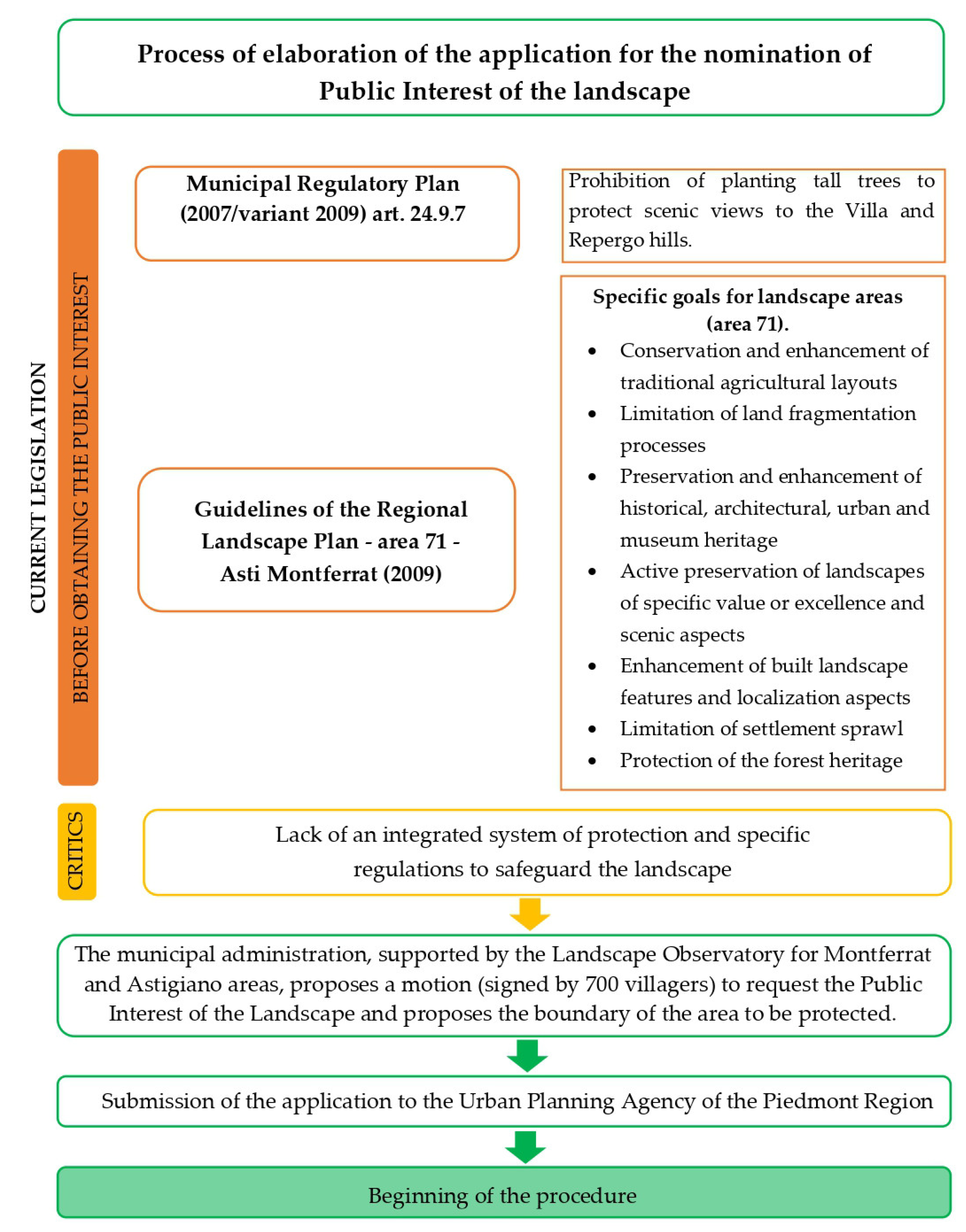
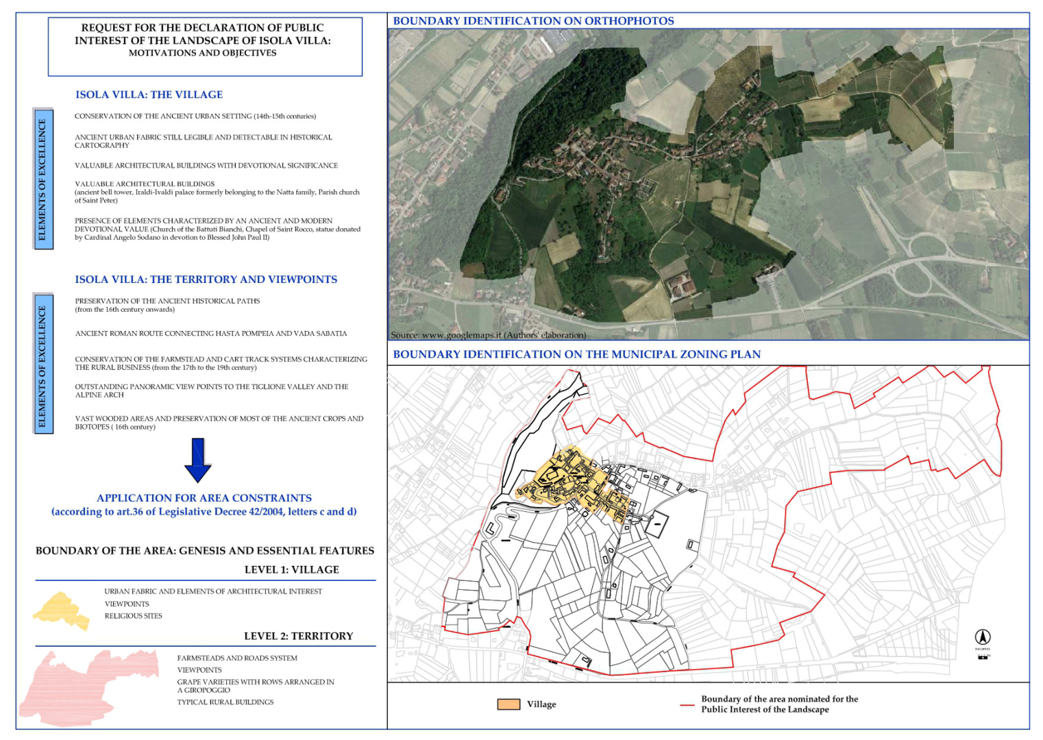
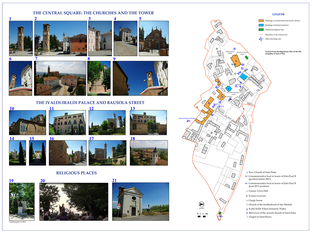
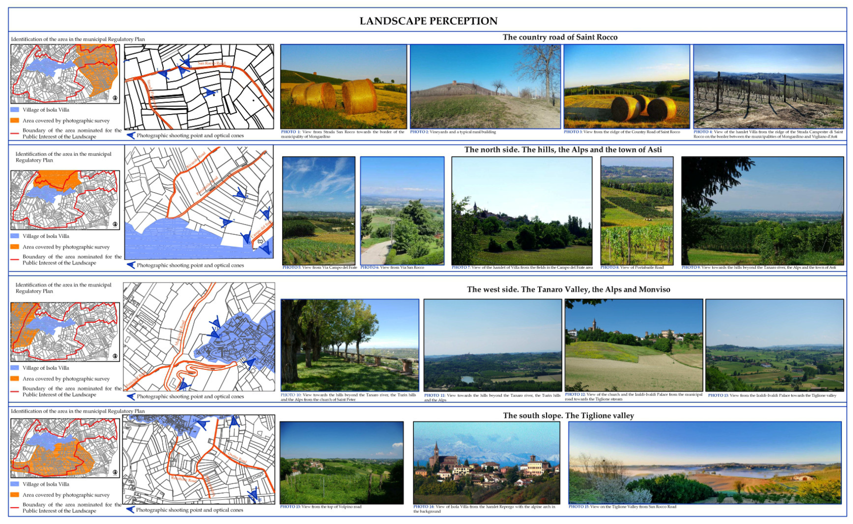
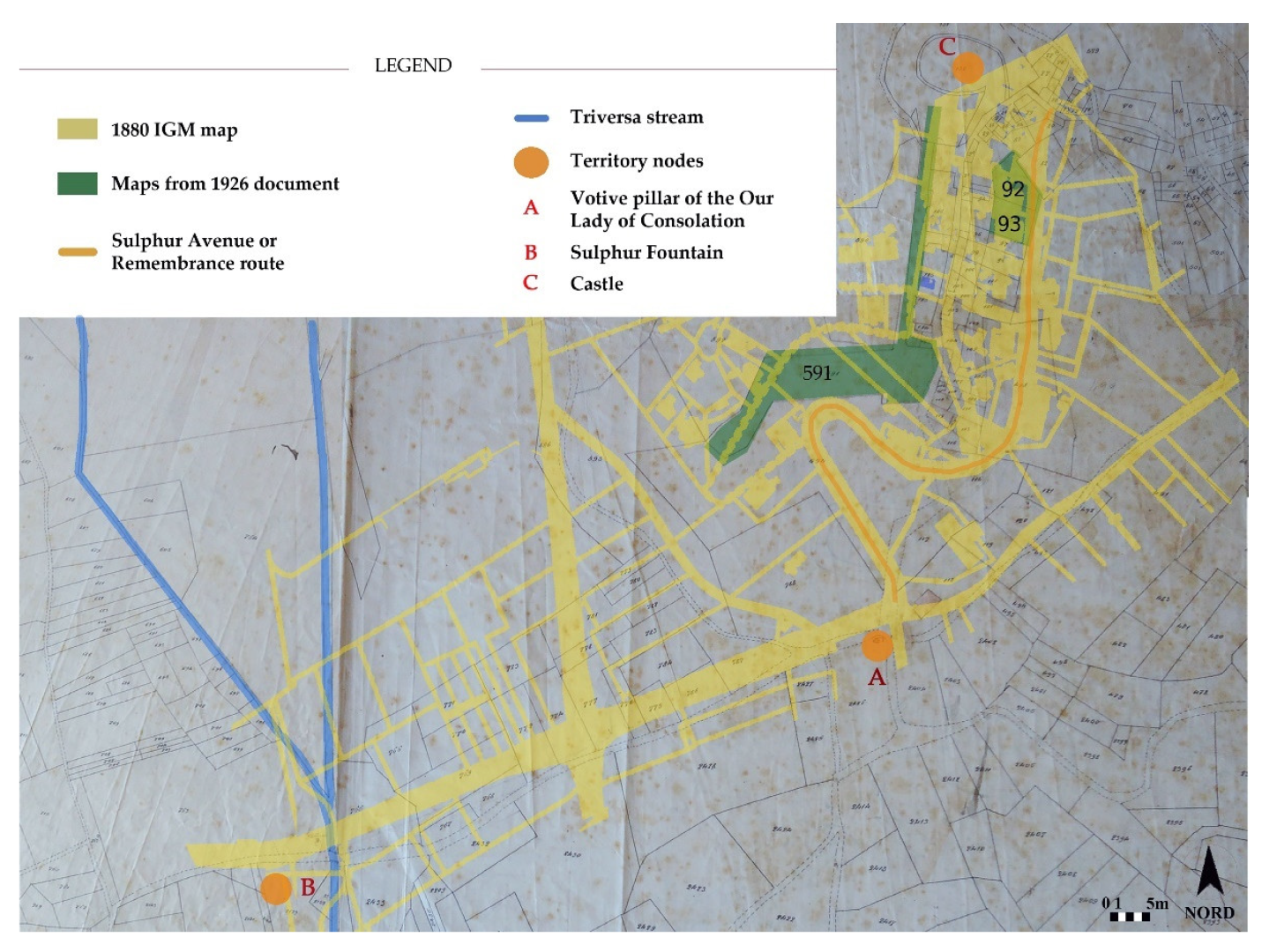
3.1. The Process of Nominating the Landscape of Isola Villa as an Area of Public Interest

The hamlet of Villa in the municipality of Isola d’Asti was the third out of eight sites in Piedmont, Italy, to apply for and to be recognized as having a public interest in its landscape through the active participation of community members. The declaration was approved by the Piedmont Regional Council by Resolution No. 39–229 on 4 August 2014 and published in the Official Bulletin of the Region No. 199 on 28 August 2014. In addition, the hamlet of Schierano in Passerano Marmorito in the province of Asti (Resolution No. 38–228 of 4 August 2014) and the Estates of the Ordine Mauriziano in the provinces of Turin and Cuneo (Resolution No. 37–227 of 4 August 2014) were approved simultaneously by the abovementioned Council.
The candidacy stemmed from the need to improve policy implementation to protect and enhance the elements of excellence in the area through a system of appropriate constraints. The conservation laws in force before obtaining the Declaration of Public Interest did not provide, in fact, the necessary tools to adequately safeguard the historic, architectural, and environmental heritage of the ancient hamlet. The municipal Regulatory Plan included protection of scenic views on the ridge of Isola Villa through the restriction of planting tall trees to prevent limiting the landscape views. However, it could not prevent buildings in areas considered to be of great environmental value. Moreover, the Landscape Plan provided some general guidance for the historic area of Montferrat in the province of Asti, but overall, there were no specific landscape constraints that could protect the existing elements of excellence, on the one hand, or prevent harmful actions against the area and views of Isola Villa, on the other hand.
In this regard, a landscape transformation proposal related to a solar power plant was submitted to the municipality in 2010 that was not consistent with the local context and was thus discarded by the local population. The proposal envisioned an installation site geographically close to the 18th-century building called Castello di Villa on the whole south-facing hillside. This installation would have compromised both the landscape and the scenic views from the village towards the valley and vice versa. The local community mobilized through public assemblies and collection of signatures with the intention of averting the plant’s construction. The Municipal Administration succeeded in preventing the plant’s construction by invoking the abovementioned article in the municipal Regulatory Plan. This episode raised the urgent need for an effective protection system that could safeguard the landscape through establishing objectives and constraints that would help direct future planning actions toward active landscape stewardship and responsible development in this area. In agreement with the Osservatorio del Paesaggio per il Monferrato e l’Astigiano (Landscape Observatory for Montferrat and Astigiano) and the Municipal Administration, a written motion was signed by 700 citizens to initiate the “Request for the Public Interest of the Landscape of Isola Villa” in June 2011, as a result of meetings at conferences and roundtables with professors from the University of Turin and the Polytechnic University of Turin and experts in the field of landscape studies. Local community awareness about the interrelated architectural and landscape value of the area in which it lived was highlighted by the active participation of the village community and its willingness to play a proactive and informed stewardship role.
The application file and request, with an attached proposal for the protected area’s boundaries, were delivered to the Piedmont region’s agency for initial assessment of prerequisites in order to launch the procedure in Autumn 2011 (Figure 3).
Detailed analyses of the different macroareas, developed according to the methodology presented in Table 1, were included in the application file. It was approved by the Piedmont region in 2014, and consequently, the protected area was established 20 days after its publication in the Official Bulletin (Figure 4, Figure 5, Figure 6 and Figure 7).

3.2. Relationships with Other Completed and Ongoing Case Studies: Linear and Single Assets, Homogeneous Regions, and Riparian Landscapes

After the nominations of Isola Villa and, shortly afterward, of the hamlet of Schierano in the municipality of Passerano Marmorito for public interest in the landscape, several other areas in the province of Asti went through the nomination process. Spatial analyses for the dossiers were based on the methodological scheme explained above but adapted to different types and characteristics of case studies. Specifically, we addressed applications for both linear, single assets and homogeneous riparian landscapes.

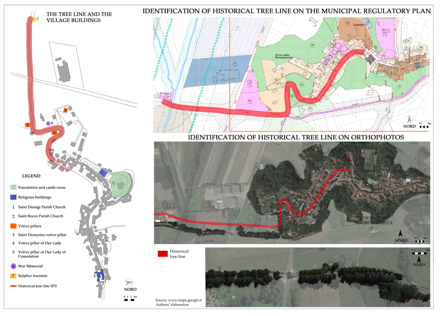
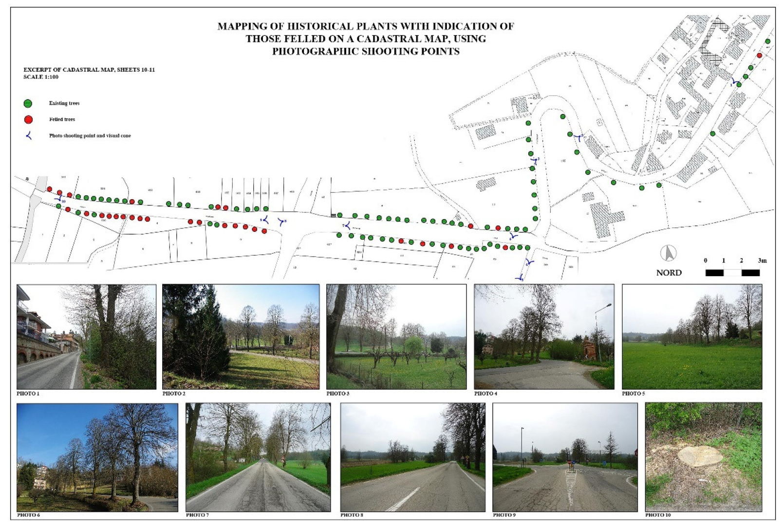
3.2.1. Linear Assets: The Historical Tree Line of Montafia (Province of Asti)

Even today, the tree-lined avenue of Montafia has a high symbolic meaning and identity value for the local community. Therefore, a request for a Declaration of Public Interest was initiated by residents, who established an association for the preservation of the linden trees because they perceived the tree-lined avenue threatened by sometimes indiscriminate cuts committed by the province of Asti. In addition to the analyses already mentioned and their replication, an accurate map of tree locations was made in this case study (Figure 8 and Figure 9), indicating the units where rapid securing was needed (Figure 10). This mapping was deemed necessary because this alley was a linear asset consisting of individual plants. Furthermore, it was decided to make a documentary film that would collect some testimonials from local people who had directly or indirectly experienced the story of the avenue. To emphasize the centrality of the trees to building local identity, an emblematic sentence was uttered by one of the children—now 90 years old—who planted the linden trees in the mid-1930s: “The lime trees are Montafia, and without them, our village would not exist”. In 2016, Montafia’s historic tree line had its landscape recognized as being of public interest under categories (a), (b), and (d) of Article 136 of Legislative Decree No. 42/2004 and the amendments of and additions to it. To further prove the completion of this process for preserving the landscape in a more proactive way at that time, the case study recently earned an honourable mention in the National Landscape Award—2021 edition, as part of the Italian shortlist vying for the Landscape Award of the Council of Europe.

3.2.2. Application in Progress

After the nominations of Isola Villa and Montafia, several other applications in the province of Asti went through the nomination process following the same analysis methodology described above. These processes are still ongoing and listed in Table 2.
However, the webpage of the Piedmont Regional Commission for Declarations of Public Interest did not mention them among the proposals for properties and areas under Article 136 of the Code of the Cultural and Landscape Heritage of the Italian State. In fact, it reported only the proposal for the hillside of the Piazza di Mondovì neighbourhood in the municipality of Mondovì (province of Cuneo), eligible for consideration by Resolution No. 54–8207 of 20 December 2018, which was enacted by the Regional Council.

4. Discussion

4.1. The Role of Public Participation in Landscape Decisions

In Europe, the European Landscape Convention of the Council of Europe defined landscape as “… a key element of individual and social well-being and that its protection, management and planning entail rights and responsibilities for everyone” [22] (Preamble). Moreover, it stated that each involved party was expected to “establish procedures for the participation of the general public, local and regional authorities, and other parties with an interest in the definition and implementation of the landscape policies …” [22] (Art. 5.c).
As a consequence, the question of public participation in choices relating to the landscape has been covered by a rather extensive literature, given the polysemic nature of landscape and the multiple reflections that the components of the socioecological system (SES) framework have on it, and vice versa. First of all, it is necessary to understand the landscape under consideration and its geographic location, as cultural values can differ between Western and Eastern philosophical approaches [23,24,25] as well as between similar landscapes in the same national context.
Then, it is necessary to clarify the physiographic region and the related types of landscape (in Italy, there are 37, for example) [26], the macrocharacter (rural, periurban, or urban), and the spatial (from micro- to large-scale landscapes) and the temporal dimensions (from paleolandscapes to future ones foreseeable in the short, medium, and long term) of the area under consideration. For example, Antrop and Van Eetvelde (2017) and Kühne (2019) explained the holistic nature of landscape through its perception and patterns, the constituent elements of its structure, and potential methods by which to analyse it [27,28]. The bottom-up approach is increasingly being integrated into the social dimension of landscape stewardship [29] using different procedures. These procedures are linked to experiential modes relating to visual, aural, olfactory, tactile, and taste perceptions [30,31,32]; aesthetics (in terms of pre- and postassessments of anthropogenic impacts on the landscape); and uses (from the preservation of places of interest to ordinary and outstanding agricultural landscapes, from livestock landscapes to energy production landscapes, etc.).
Planning is another subject area that is concerned with landscape studies, both in terms of design and regulation. For example, Larcher et al. (2013) and Gullino et al. (2018) encouraged and made use of a bottom-up approach to stakeholder involvement in coplanning rural historic landscapes in different areas of the Italian Piemonte [33,34]. Aimar et al. (2021) also recognized the need for involving local stakeholders to “better support the management of land-use changes, also involving local farmers directly to reconstruct site-specific land-use maps” [35] (p. 460). Furthermore, the interdisciplinary contributions of history [36], geography [37], anthropology [38], sociology [39], semiology [40], psychology [41], art [42], agronomy [43], botany [44], zoology [45], landscape ecology [46], pedology [47], geology [48], climatology [49], economics [50], and planning [51], among others, contribute to the effectiveness of an integrated management for heritage sites. In recent decades, these disciplines have gained the adjectives “sustainable” and/or “resilient” with respect to their operational status in terms of strategies, objectives, and actions related to landscape and territory. Compound words such as “spatial resilience” have appeared in the literature [52], as well as those of “landscape resilience” [53,54] and “landscape sustainability” [55].
The case studies selected in this paper, of which the landscape areas fell in the province of Asti, Piedmont, showed intervisibility problems due to their hillside settings (i.e., vistas to and from such areas). Therefore, the studied landscapes were both ordinary and outstanding cultural (i.e., UNESCO) ones that addressed current issues and pressures to provide them with the basics for proper management and ensure their continuation. Against the backdrop of complexity and changes, the availability of these procedures was made known to stakeholders and local communities in the province of Asti as part of the awareness-raising process carried out by the Landscape Observatory for Montferrat and Astigiano. The Observatory was founded by a multidisciplinary team consisting of agronomists, nature conservationists, architects, planners, landscape architects, historians, sociologists, high school teachers and university lecturers, and organizational representatives of the agricultural entrepreneurs, local park authorities, and third sector workers in Soglio in the province of Asti, Piedmont (2003). The main aim was to implement the European Landscape Convention (2000) and its ensuing Guidelines (2008). Appendix 1 to the Guidelines for the implementation of the Council of Europe Landscape Convention [56] listed several useful tools for this purpose. Among them, Art. 10 pointed out the importance of creating landscape observatories, centres, or institutes allowing “observation on the basis of appropriate study protocols employing a range of indicators” as well as “the collection and exchange of information on policies and experience” [56]. As Devecchi stated, the latter “are modelled on a bottom-up strategy of citizen involvement, in which the ‘expertise’ interacts with the ‘diffuse know-how’ of the people” [57] (p. 139).
The importance of this Observatory in the “knowledge, conservation, and promotion” [14] (p. 555) of “the culture of the landscape and the environment” [14] (Management Plan, p. 24) was also acknowledged by the Nomination Dossier of the World Heritage Site titled the “Vineyard Landscape of Piedmont: Langhe-Roero and Monferrato”, which explicitly mentioned it twice [14] (pp. 555, 606). It continued to state that this association, which among the trio of Landscape Observatories operating in the UNESCO site, had “gained experience that till now is unique throughout Italy” [14] (p. 606). It is believed that this experience can have international significance in landscape research. The Observatory is part of the Network of Landscape Observatories in Piedmont, set up in 2006 and made up of a total of 10 subregional bodies, namely: the Landscape Observatory for the Casale Monferrato area, the Alessandria Landscape Observatory, the Biella Observatory—Cultural Heritage and Landscape, the Landscape Observatory of the Po River Park and the Turin Hills, the Landscape Observatory for the Moraine Amphitheatre of Ivrea, the Landscape Observatory for the protection of Langhe and Roero, the Mongioie Landscape Observatory, the Landscape Observatory for the Upper Bormida and Uzzone Valleys, and the Landscape Observatory for the Western Ticino and Novarese lowlands. The Biella and Ivrea Observatories are also members of the international CIVILSCAPE federation, which is devoted to stimulating community involvement in landscape decision making.
Since Observatories can be considered as “one of the most suitable tools to move a community forward” [57] (p. 140) on environmental and landscape problems, the Landscape Observatory for Montferrat and Astigiano acted in this way. It proposed the participatory conservation of the Asti landscape with interesting initiatives from a methodological point of view, supporting communities in requests for Declarations of Public Interest in the landscape based on the Code of the Cultural and Landscape Heritage of the Italian State [19].

4.2. Community Engagement in Landscape Decisions

The significance of the Declarations of Public Interest in the province of Asti (Piedmont, Italy) has already been highlighted by the UNESCO Nomination Dossier for the “Vineyard Landscape of Piedmont: Langhe-Roero and Monferrato” [14] as a World Heritage Site. Precisely, the site management plan claimed that they were “one of the most interesting events in the field of the landscape’s protection, demonstrating a clear participation of the citizenry towards the challenges of the landscape” [14] (p. 80).
The operational opportunities arising in the processes related to the Declarations of Public Interest in the province of Asti were presented to the locals at a specific meeting in Cortiglione by the organizing committee for the protection and enhancement of local heritage in July 2007. This public meeting was also held in San Marzanotto in 2010 when it was arranged by a spontaneous committee in Belangero and the Council of Environmental Organizations of the province of Asti. It consisted of 13 bodies, including the Landscape Observatory for Montferrat and Astigiano. The public reading of the Italian Constitution and the Code of the Cultural and Landscape Heritage of the Italian State led to the signing by the population of three posters requesting the protection of the San Marzanotto landscape through the recognition of its public interest. Signed by about 50 people, they were scaled down to A3 and sent to the Piedmont region, the Ministry of Cultural Heritage and Activities, and the Council of Europe. This request in the Piedmont region triggered the Commission on the topic, which was not yet operative at the time.
After a period of reflection and analysis of the operational possibilities by the local populations, in 2010, the first requests came for the hamlets of San Marzanotto, Isola Villa, and Schierano, as well as for Canelli. All of these were conceptualized by the conscious desire of local community members using a bottom-up process. The novelty concerning previous cases was the unanimous approval by the municipal councils of Isola d’Asti (for the hamlet of Isola Villa) and Passerano Marmorito (for the hamlet of Schierano) of the applications concerned. These first three were followed by applications to obtain Declarations of Public Interest in the River Tanaro riparian landscape (2013, 2015); the historical tree line of Montafia (2013); the vineyard landscapes of Mombercelli (2014); the swamp of Agliano Terme, Calosso, and Costigliole d’Asti, (2015); the cave dwellings of the hamlet of Mombarone (municipality of Asti, 2015); and the landscape of San Martino Alfieri (2018). In the case of Isola Villa, the valuable elements of the local landscape were first debated at a public conference, using digital slides of the settlement and indicating the perimeter of the area under examination. At the end of the session, the request for the Declaration of Public Interest in the Isola Villa landscape was publicly signed by participants and attendees. Then, the formal handing over of the request took place during another public conference attended by villagers. It was delivered by the mayor of Isola d’Asti and the representative of the Belangero Committee to the Director of Strategic Planning and Territorial and Building Policies of the Piedmont region.
Similarly, in the case of Montafia, the will to request a Declaration of Public Interest arose during a public meeting held to debate with officials from the province of Asti the reasons behind the felling of the linden trees along the provincial road. This meeting was held on the occasion of the National Tree Festival in the Montafia town council hall on 21 November 2013. This meeting was facilitated and supported by the Landscape Observatory for Montferrat and Astigiano and the Circolo Legambiente Valtriversa. At the meeting, the convinced interest of the local population emerged for the conservation, preservation, and restoration of the historical trees in question, given their botanical relevance, historical importance, and landscape value. The two abovementioned bodies worked to make citizens aware of this candidacy opportunity, supporting the creation of the local Association titled “Terra, Boschi, Gente e Memorie”.
For example, in the case of Mombercelli, the Association for the Defence of Valtiglione and its Surroundings acted for the application. Similarly, various associations such as the Amici di Calosso, the Lega Italiana Protezione Uccelli (the Italian equivalent of the Royal Society for the Protection of Birds in the United Kingdom), and the Asti Paleontological Park acted for the wetland landscape (“paludo” in Italian) in the municipalities of Agliano Terme, Calosso, and Costigliole d’Asti. The request was accepted by issuing a decree concerning special protection measures for the requested areas in Isola Villa (Isola d’Asti), Montafia, and the wetland of Agliano Terme, Calosso, and Costigliole d’Asti. The latter became a nature reserve in 2019, as explained in detail below.
These recognitions represent a relevant step in the proactive perspective of involving and promoting the shared decision-making with local people in landscape management. Furthermore, this procedure was useful for raising public awareness about the possibility to actively influence spatial policy decisions by applying community-driven development and people-centred approaches. Moreover, such recognitions can be instrumental in strengthening local identity [57], even in ordinary landscapes. Community inclusion, engagement, and empowerment are keys to striving for integrated landscape management, which becomes more resilient as the decision-making group that determines management objectives, strategies, and actions is expanded. The recognitions confirm what was identified by scholars such as Biggs et al. [58,59], who suggested broadening participation as one out of seven principles for build and enhance the resilience of ecosystem services in social–ecological systems. Moreover, the presented case studies confirm how “broad and well-functioning participation can build trust, create a shared understanding and uncover perspectives that may not be acquired through more traditional scientific processes.” [60] (p. 15). Therefore, broad participation is relevant to the debate over transformations that significantly impact the landscape image. It follows that this debate should therefore be more widely shared, as it often affects perceptual experience and its visual quality, “resulting in negative consequences for future generations” [61] (p. 2).

4.3. Declarations of Public Interest in Other Italian Regions and in Europe: A Comparison

The Declaration of Public Interest in the Landscape, as provided by Legislative Decree No. 42 of 2004, has been used as a protection tool in several Italian regions, especially in the centre north. Underlying it, as in the Piedmont cases, is the willingness of local communities and individual citizens to actively participate in the protection and enhancement of the territories in which they live. Among the Italian regions most engaged in this topic are Marche, Veneto, Lombardy, and Piedmont. Each of them has drawn up general methodological guidelines for drawing up application files and established minimum requirements for submissions.
The following tables compare the numbers of sites declared of public interest for their landscape through public participation, the guidelines for applications, and the minimum documentation required for applications in the four Italian regions mentioned above.
The structuring and complexity of the minimum analyses required vary from region to region. More specifically, Piedmont requires very structured and detailed documentation at both cartographic and photographic–perceptual levels. Conversely, Marche gives much more concise indications, while for Lombardy and Veneto, there is no minimum documentation required, only a reference to the contents of Art. 138 of Legislative Decree No. 42/2004 Code of the Cultural and Landscape Heritage of the Italian State (Table 3, Table 4, Table 5 and Table 6).
From the regional cases cited above, the documentation required by Piedmont appears to be replicable for assessments of other sites in different countries. The context analysis through historical and iconographic sources of the landscape palimpsest, as requested in Annexes C.1 and C.2, leaves room for new multilayer analysis tools based on data and digital resources (virtual or augmented reality, for example). However, attention should be paid to potential differences depending on the application context, namely:
  • concerning Annexes A and B, the actual level of active involvement of citizenship within the existing regulatory framework in countries that are politically and administratively different from European ones [62];
  • concerning Annex C.3, the diversity of approaches in spatial governance policies and the regulatory tools associated or associable with them.
In different European countries, similar experiences have been had with applications for Declarations of Public Interest in landscapes. In France, the Code de l’Environnement (2000), in “Titre V: Paysages” [63], identifies territories that are distinguished by landscape elements of excellence and past agricultural and craft traditions, encouraging local communities to promote their protection and enhancement. In Germany, the German Federal Act for the Protection of Nature (2002) indicates the areas under protection in terms of biodiversity, landscape views, scenic beauty, and being shaped by human work. Moreover, in the Netherlands, the Nota Ruimte (2006) identifies 20 National Landscapes to address the problem of diminishing landscape quality.
Lastly, in the United Kingdom are the so-called Areas of Outstanding Natural Beauty (AONBs), each of which is defined as “land protected by the Countryside and Rights of Way Act 2000 (CROW Act). It protects the land to conserve and enhance its natural beauty.” [64]. They are made up of areas of different sizes that present elements of physical–naturalistic and historical–architectural excellence. Their protection and enhancement are entrusted to local administrations and the citizens who live and work within them. The National Association for Areas of Outstanding Natural Beauty (NAAONB) deals with their promotion and enhancement.

4.4. Current Considerations in Land Development after the Promulgation of Declarations of Public Interest: Mayors and Municipal Administrators

In the final stages of the project, a mixed-method survey was used to verify and test the goodness of the declarations and to understand potential improvements or problems that emerged over time. To understand the territorial evolution after the entry into force of the Declarations of Public Interest in the municipalities of Isola d’Asti (in 2014), Passerano Marmorito (in 2014) and Montafia (in 2016), the mayors and municipal administrators (i.e., councillors with responsibility for the landscape) were asked to respond to an online questionnaire. Prepared by the authors in advance, the questionnaire consisted of ten semistructured questions, providing a list of closed and multiple-choice questions while allowing the interviewees to add their opinions on some questions (Q2, Q4, Q6, Q7, Q8 and Q9). Response time was estimated by experts to be less than five minutes and could have been dependent on different factors (accuracy, age, and familiarity with the topics, among others). Launched in early April 2021, the survey was designed using Google Forms and submitted online to six public administrators anonymously (two per the abovementioned municipality), with answers being returned in the same way. The six responses received were from public administrators during the period 06 to 21 April 2021. For the sake of transparency and reproducibility of this original study, the questions submitted are listed below:
Q1.
Do you feel that the landscape is a valuable asset to the municipality you govern? (Yes; no);
Q2.
If yes, for what reason? (Economic/tourist; economic/real estate; improving agricultural production; identity/cultural; other: please specify);
Q3.
In your opinion, does the Declaration of Public Interest of the landscape in your municipality reinforce the above reasons? (Yes; no);
Q4.
Years after the declaration was accepted and approved, how do you rate it? (Very good; good; fair; poor; very bad: please specify);
Q5.
When troubles arose, have they affected only villagers in their real estate asset management, the municipal government, or both? (Villagers; municipal government; both);
Q6.
When troubles arose, what were they specifically? (Bureaucratic complications/administrative burdens; increased costs in dossier preparation, submission, and management; longer timeframes for the start/execution of works; other: please specify);
Q7.
When confronted with any problems, do you think that more careful landscape management after the declaration has allowed and will allow protecting and sustaining the landscape qualities in your municipality, including for the benefit of future generations? (Yes; no; maybe. Please specify);
Q8.
Do you have any suggestions for improving administrative processes even in the presence of a protected landscape area related to the recognition of the public interest? (Simplification of administrative procedures in the local landscape committees; additional technical/administrative support from the Piedmont region; additional funding for these areas; other: please specify);
Q9.
Do you think that there might be other sites in your municipality that would merit recognition of public interest due to their landscape? (Yes; no. please specify);
Q10.
Would you advise other mayors to follow the same landscape conservation approach pioneered by the municipality under your administration in recent years? (Yes; no).
In terms of aggregated answers, Question 1 (Q1) received responses of “yes” from six out of six voters (100%), confirming the importance of the landscape at the local level. The second query (Q2) clarified the reasons, which were economic/tourist for four out of six voters (67%) and identity/cultural for the remaining two (33%). However, they all agreed that the declaration was fit for the purpose of reinforcing the mentioned reasons, with the third question (Q3) receiving “yes” responses from 6 out of 6 respondents (100%). Consistently, as revealed by question four (Q4), ratings of the level of satisfaction with the preconditions of the application were very positive for four out of six voters (67%), positive for one, and fair for one, thus yielding dissatisfaction or negative opinions. Assuming overall satisfaction, the fifth query (Q5) sought to highlight possible issues detected over the years. Four out of six voters acknowledged problems that hit the private and public sectors (67%), and the other two acknowledged only problems affecting the private sector (33%). The sixth query (Q6) clarified the nature of these difficulties, which were mainly due to bureaucratic complications/administrative burdens (67%, i.e., four out of six voters) and, to a lesser extent, a mix of the aforementioned three in Q6 (17%, i.e., one out of six voters). For one respondent, no problems emerged. Despite these concerns, the seventh query (Q7) confirmed the overall benefits of the preservation initiative, with six out of six positive responses (100%). However, in the eighth query (Q8), most voters lamented the apparent lack of supplemental funding to be allocated to areas designated by the declaration (83%, i.e., five out of six voters), while the other identified all three of the proposed issues (17%, i.e., one out of six voters). This could be a wake-up call for regional administrators to think about, as in the following question (Q9), most voters (83%, or five out of six) said that there were further areas in their municipality that could potentially merit applying for declarations. In conclusion, considering the pros and cons of the recognition, years later, all mayors would recommend the introduction of these conservation measures to other colleagues (100%, i.e., six out of six voters, in Q10).

4.5. Current Considerations in Land Development after the Promulgation of Declarations of Public Interest: The Territory and Landscape Sector of the Piedmont Region

Specific open-ended comments were made on the above statements regarding the Piedmont region’s website, potential funding, and the various regulations governing landscape protection and enhancement.
The first was made on the institutional website of the Piedmont region, which shows the declaration requests in the province of Asti listed in Table 2. The Commission’s webpage shows only statements for which the administrative process has been completed, i.e., in which public interest has been declared by a resolution of the Regional Council. Where appropriate, the “Proposed Statements” section also shows applications in progress, i.e., of which the preliminary review has been completed by the Commission and are which are therefore awaiting finalization by a decision of the regional government. On the other hand, it is not surprising that there were no applications here that had been sent to the Commission but that the Commission had not yet had a chance to examine and the admissibility of which was therefore uncertain. The repeated periods of suspension of the Commission’s activities—recently due to the pandemic, previously and on several occasions as a result of the multiple reorganizations of the Ministry’s territorial offices (Superintendencies and Regional Secretariat)—have created a queue of unresolved questions.

5. Conclusions

Participatory landscape management is a topic of great importance because of how it raises community interest. Therefore, bottom-up initiatives on a territorial level need to be more operationalized within the traditional top-down transcalar (international, national, regional, provincial, and municipal) legislative framework. Declarations of Public Interest are relevant in these circumstances as top-level examples of bottom-up initiatives allowed by the Italian State for citizen participation in proactive landscape management. One of the most innovative aspects of applications for public interest in landscapes is the active participation of community members experiencing and inhabiting places. This is a fundamental aspect for the active protection of an area where the locals themselves recognize its value, as these locals regain aspects of their cultural identities associated with the area. The establishment of citizens’ associations in the reported case studies requesting institutional recognition of the public interest in their landscapes overturns the conventional paradigm of command-and-control, top-down conservation. Moreover, such applications can strengthen place attachment in the local landscape, identity [57], and community sense of place, as in the case studies of Isola Villa in the municipality of Isola d’Asti and Schierano in the municipality of Montafia (Piedmont, Italy). An expanded and informed community exercising landscape-scale thinking and decision making reaffirms the importance of landscape as an inclusive, common, and plural good [65,66]. In a nutshell, Declarations of Public Interest represent an innovative approach to the principle of subsidiarity in land governance.
Therefore, making the methodological framework established by the authors known to the scientific community, as a guide to completing the procedure for Declarations of Landscape Interest in the province of Asti, appears important to inspire inclusive community practices. Moreover, it can further support scholars build shared paths to enhancement and management at other sites.
Although the evidence showed that Declarations of Public Interest were successful examples for channelling bottom-up, proactive demands, some considerations did arise.
Regarding the hope that emerged from the interviews with local administrators, i.e., that the declarations would bring with them regional funding to ensure the protection and enhancement of the affected landscapes, it was confirmed that there are currently no regional laws that provide for this. According to the Code of the Cultural and Landscape Heritage of the Italian State (2004) and the related Regional Act no 32/2008, declarations are protection measures (as suggested by the traditional definition of landscape “constraints”) and not enhancement measures. In this regard, the two concepts cannot always coexist, since sometimes the protection of a given landscape may suggest imposing its unavailability for use. Relevant cases in Italy would include a marine reserve or a high-altitude nature park.
This also relates with the lack of regulatory integration between the European Landscape Convention (2000) and the abovementioned Italian Code (2004), as the Convention is part of a framework of countries with very different and often nonexistent landscape legislative traditions. In 2010, in Italy, the law in force was No. 1497/1939, transposed almost literally in Part III of the Code. This law emphasized the concept of protection but did not cover that of enhancement. The recent combination of protection and enhancement of the landscape derived from a coordinated reading of the Convention and the Code, where the most important regulatory requirement was assigned to Legislative Decree No. 42/2004. The two instruments were mentioned and integrated in Piedmont regional law No. 14/2008, “Norms for the enhancement of the landscape”, which provided for a program of interventions to finance actions in support of the landscape but did not give priority to actions concerning territorial areas subject to protection measures. To date, none of the local governments that promoted their statements of significant public interest has applied for cofunding under Act 14.
Despite the above, the procedure described in the paper did not recommend any restrictions on its adoption or implementation, since the landscape is a common public good [65] (Art. 7) that satisfies subjective and objective interests. Moreover, it could be easy to implement the European Landscape Convention [67] in the 40 countries that have already signed it, ratified it, and put it into force. The procedure described herein could also serve as a useful tool to stimulate consciousness raising in local communities in the six member countries of the Council of Europe that have not yet even signed the convention [67].
This implemented procedure could be adopted in other Italian and international case studies to encourage useful reflections on landscape resilience [53,54] as a bottom-up contribution to landscape planning and design strategies [68].
Assessing performance and related criteria, as well as the key aspects of performance, were not within the scope of this survey; however, this paper can be used to support further studies in this field, as in other aspects of the place attachment of local communities to their cultural heritage.

Author Contributions

Conceptualization, F.A., F.C. and M.D.; Investigation, F.A., F.C. and M.D.; Methodology, F.C.; Resources, F.A., F.C. and M.D.; Supervision, M.D.; Validation, M.D.; Visualization, F.A., F.C. and M.D.; Writing—original draft, F.A. and F.C.; Writing—review & editing, F.A. All authors have read and agreed to the published version of the manuscript.

Funding

This research received no external funding.

Institutional Review Board Statement

Not applicable.

Informed Consent Statement

Not applicable.

Acknowledgments

The authors would like to thank Enrico Ferro, Angelo Porta, the villagers of Montafia and the Cultural Association ‘I Nostri Tigli’, Giovanni Paludi, Paola Gastaldi, Elisa Olivero and Francesco Alberti La Marmora.

Conflicts of Interest

The authors declare no conflict of interest.

References

  1. Perrotti, D. Studying the Metabolism of Resilient Communities: Urban Practices, Micronarratives, and Their Agency. In Resilient Communities and the Peccioli Charter, 1st ed.; Carta, M., Perbellini, M.R., Lara-Hernandez, J.A., Eds.; Springer: Cham, Switzerland, 2022; pp. 51–57. [Google Scholar]
  2. ICCROM. People-Centred Approaches to the Conservation of Cultural Heritage: Living Heritage; ICCROM: Rome, Italy, 2015; Available online: https://www.iccrom.org/sites/default/files/PCA_Annexe-2.pdf (accessed on 26 August 2021).
  3. ICOMOS. Resolution 20GA/19. People-Centred Approaches to Cultural Heritage. 2019. Available online: https://www.icomos.org/images/DOCUMENTS/Secretariat/2021/OCDIRBA/Resolution_20GA19_Peolple_Centred_Approaches_to_Cultural_Heritage.pdf (accessed on 26 August 2021).
  4. Stenseke, M. Local participation in cultural landscape maintenance: Lessons from Sweden. Land Use Policy 2009, 26, 214–223. [Google Scholar] [CrossRef]
  5. Mu, Q.; Aimar, F.; Chen, L. The joint force of bottom-up and top-down in the Preservation and Renewal of Rural Architectural Heritage, taking Piedmont, Italy as the case study. Jianzhushi 2021, 209, 51–57. [Google Scholar] [CrossRef]
  6. Santoro, A.; Venturi, M.; Agnoletti, M. Landscape Perception and Public Participation for the Conservation and Valorization of Cultural Landscapes: The Case of the Cinque Terre and Porto Venere UNESCO Site. Land 2021, 10, 93. [Google Scholar] [CrossRef]
  7. Treccani. Parchi Naturali. 1994. Available online: https://www.treccani.it/enciclopedia/parchi-naturali_%28Enciclopedia-Italiana%29/ (accessed on 18 June 2022).
  8. Lange Vik, M. Self-mobilisation and lived landscape democracy: Local initiatives as democratic landscape practices. Landsc. Res. 2017, 42, 400–411. [Google Scholar] [CrossRef]
  9. Arler, F.; Mellqvist, H. Landscape Democracy, Three Sets of Values, and the Connoisseur Method. Environ. Values 2015, 24, 271–298. [Google Scholar] [CrossRef]
  10. Jacobson, C.; Robertson, A.L. Landscape Conservation Cooperatives: Bridging Entities to Facilitate Adaptive Co-Governance of Social–Ecological Systems. Hum. Dimens. Wildl. 2012, 17, 333–343. [Google Scholar] [CrossRef]
  11. Thompson, J.R.; Elmendorf, W.F.; McDonough, M.H.; Burban, L.L. Participation and Conflict: Lessons Learned from Community Forestry. J. For. 2005, 103, 174–178. [Google Scholar] [CrossRef] [Green Version]
  12. Regione Piemonte. Siti di Importanza Regionale (SIR). Dati Territoriali Comunali. 2020. Available online: http://giscartografia.csi.it/Parchi/sir_comuni_elenco.pdf (accessed on 28 August 2021).
  13. Regione Piemonte. Risultato Ricerca Schede Siti di Importanza Comunitaria (SIC) in Piemonte. N.d. Available online: http://www.regione.piemonte.it/habiweb/ricercaSic.do (accessed on 19 August 2021).
  14. UNESCO. The Vineyard Landscape of Piedmont: Langhe-Roero and Monferrato, Executive Summary, Nomination Format Book 1, Nomination Format Book 2, Management Plan. 2014. Available online: https://whc.unesco.org/uploads/nominations/1390rev.pdf (accessed on 9 July 2021).
  15. ISTAT. Resident Population on 1st January: Piemonte. 2022. Available online: http://dati.istat.it/?lang=en&SubSessionId=28f6b316-8c04-4ada-9c4d-4009a9d99fc5 (accessed on 6 July 2022).
  16. Comuni Italiani. Isola d’Asti—Redditi Irpef. 2015. Available online: http://www.comuni-italiani.it/005/059/statistiche/redditi.html (accessed on 6 July 2022).
  17. Comuni Italiani. Montafia—Redditi Irpef. 2015. Available online: http://www.comuni-italiani.it/005/073/statistiche/redditi.html (accessed on 6 July 2022).
  18. Republic of Italy. Constitution of the Italian Republic. 1947. Available online: https://www.senato.it/documenti/repository/istituzione/costituzione_inglese.pdf (accessed on 21 July 2021).
  19. Italian Ministry for Culture. Legislative Decree no. 42 of 22 January 2004—Code of the Cultural and Landscape Heritage, pursuant to article 10 of law no. 137 of 6 July 2002. 2004. Available online: https://whc.unesco.org/document/155711 (accessed on 12 July 2021).
  20. Regione Piemonte. Legge Regionale 1 Dicembre 2008, n. 32. (Testo Coordinato). Provvedimenti Urgenti di Adeguamento al Decreto Legislativo 22 Gennaio 2004, n. 42 (Codice Dei Beni Culturali e del Paesaggio, ai Sensi dell’articolo 10 della Legge 6 Luglio 2002, n. 137). 2008. Available online: http://www.regione.piemonte.it/governo/bollettino/abbonati/2008/49/suppo2/00000004.htm (accessed on 12 July 2021).
  21. Regione Piemonte. Documentazione di Riferimento per la Presentazione delle Richieste di Dichiarazione di Notevole Interesse Pubblico—D.lgs. 42/2004, Art. 137–140. 2011. Available online: https://www.regione.piemonte.it/web/sites/default/files/media/documenti/2018-11/commissione_regionale_documento.pdf (accessed on 12 December 2021).
  22. Council of Europe (CoE). European Landscape Convention. 2000. Available online: https://www.coe.int/en/web/conventions/full-list/-/conventions/rms/0900001680080621 (accessed on 12 July 2021).
  23. Taylor, K. Cultural Landscapes and Asia: Reconciling International and Southeast Asian Regional Values. Landsc. Res. 2009, 34, 7–31. [Google Scholar] [CrossRef]
  24. Fischer, N. Landscape, Landscape History, and Landscape Theory. In A Companion to the Anthropology of Europe, 1st ed.; Kockel, U., Craith, M.N., Frykman, J., Eds.; Wiley-Blackwell: Hoboken, NJ, USA, 2012. [Google Scholar] [CrossRef]
  25. Zhang, R.; Taylor, K. Cultural landscape meanings. The case of West Lake, Hangzhou, China. Landsc. Res. 2020, 45, 164–178. [Google Scholar] [CrossRef]
  26. ISPRA. I Tipi e le Unità Fisiografiche di Paesaggio. n.d. Available online: https://www.isprambiente.gov.it/it/servizi/sistema-carta-della-natura/carta-della-natura-alla-scala-1-250.000/i-tipi-e-le-unita-fisiografiche-di-paesaggio (accessed on 13 July 2021).
  27. Antrop, M.; Van Eetvelde, V. Landscape Perspectives. The Holistic Nature of Landscape, 1st ed.; Springer: Dordrecht, The Netherlands, 2017. [Google Scholar] [CrossRef]
  28. Kühne, O. Landscape Theories. A Brief Introduction, 1st ed.; Springer: Wiesbaden, Germany, 2019. [Google Scholar] [CrossRef]
  29. Golobič, M. Transformation Processes of Alpine Landscapes and Policy Responses: Top-Down and Bottom-Up Views. Soc. Nat. Resour. 2018, 23, 269–280. [Google Scholar] [CrossRef]
  30. Dann, G.; Steen Jacobsen, J.K. Tourism smellscapes. Tour. Geogr. 2010, 5, 3–25. [Google Scholar] [CrossRef]
  31. Dupont, L.; Antrop, M.; Van Eetvelde, V. Eye-tracking Analysis in Landscape Perception Research: Influence of Photograph Properties and Landscape Characteristics. Landsc. Res. 2014, 39, 417–432. [Google Scholar] [CrossRef]
  32. Chen, M.; Zhang, J.; Zhang, Y.; Wu, K.; Yang, Y. Rural Soundscape: Acoustic Rurality? Evidence from Chinese Countryside. Prof. Geogr. 2021, 73, 521–534. [Google Scholar] [CrossRef]
  33. Larcher, F.; Novelli, S.; Gullino, P.; Devecchi, M. Planning Rural Landscapes: A Participatory Approach to Analyse Future Scenarios in Monferrato Astigiano, Piedmont, Italy. Landsc. Res. 2013, 38, 707–728. [Google Scholar] [CrossRef] [Green Version]
  34. Gullino, P.; Devecchi, M.; Larcher, F. How can different stakeholders contribute to rural landscape planning policy? The case study of Pralormo municipality (Italy). J. Rural Stud. 2018, 57, 99–109. [Google Scholar] [CrossRef]
  35. Aimar, F.; Gullino, P.; Devecchi, M. Towards reconstructing rural landscapes: A case study of Italian Mongardino. J. Rural Stud. 2021, 88, 446–461. [Google Scholar] [CrossRef]
  36. Sereni, E. Storia del Paesaggio Agrario Italiano, 1st ed.; Laterza: Bari, Italy, 1961. [Google Scholar]
  37. Alomar-Garau, G.; Gómez-Zotano, J.; Arias-García, J. Teaching landscape in Spanish universities: Looking for new approaches in Geography. J. Geogr. High. Educ. 2017, 41, 264–282. [Google Scholar] [CrossRef]
  38. Isager, L.; Broge, N.H. Combining remote sensing and anthropology to trace historical land-use changes and facilitate better landscape management in a sub-watershed in North Thailand. Landsc. Res. 2007, 32, 147–169. [Google Scholar] [CrossRef]
  39. Arnberger, A.; Eder, R. Exploring the Heterogeneity of Rural Landscape Preferences: An Image-Based Latent Class Approach. Landsc. Res. 2011, 36, 19–40. [Google Scholar] [CrossRef]
  40. Raaphorst, K.; Duchhart, I.; van der Knaap, W.; Roeleveld, G.; van den Brink, A. The semiotics of landscape design communication: Towards a critical visual research approach in landscape architecture. Landsc. Res. 2017, 42, 120–133. [Google Scholar] [CrossRef] [Green Version]
  41. Huang, S.; van den Bosch, C.K.; Fu, W.; Qi, J.; Chen, Z.; Zhu, Z.; Dong, J. Does Adding Local Tree Elements into Dwellings Enhance Individuals’ Homesickness? Scenario-Visualisation for Developing Sustainable Rural Landscapes. Sustainability 2018, 10, 3943. [Google Scholar] [CrossRef] [Green Version]
  42. Repetto, D.; Aimar, F. The Fifth Landscape: Art in the Contemporary Landscape. In Digital Draw Connections, 1st ed.; Bianconi, F., Filippucci, M., Eds.; Springer: Cham, Switzerland, 2021; pp. 683–706. [Google Scholar] [CrossRef]
  43. Rizzo, D.; Marraccini, E.; Lardon, S.; Rapey, H.; Debolini, M.; Benoît, M.; Thenail, C. Farming systems designing landscapes: Land management units at the interface between agronomy and geography. Geogr. Tidsskr. 2013, 113, 71–86. [Google Scholar] [CrossRef]
  44. Rotchés-Ribalta, R.; Winsa, M.; Roberts, S.P.M.; Öckinger, E. Associations between plant and pollinator communities under grassland restoration respond mainly to landscape connectivity. J. Appl. Ecol. 2018, 55, 2822–2833. [Google Scholar] [CrossRef]
  45. Josefsson, J.; Pärt, T.; Berg, Å.; Lokhorst, A.M.; Eggers, S. Landscape context and farm uptake limit effects of bird conservation in the Swedish Volunteer & Farmer Alliance. J. Appl. Ecol. 2018, 55, 2719–2730. [Google Scholar] [CrossRef]
  46. van Diggelen, R.; Hobbs, R.J.; Miko, L. Landscape Ecology. In Restoration Ecology: The New Frontier, 1st ed.; van Andel, J., Aronson, J., Eds.; Wiley-Blackwell: Hoboken, NJ, USA, 2012. [Google Scholar] [CrossRef]
  47. Pinheiro, H.S.K.; dos Anjos, L.H.C.; Xavier, P.A.M.; Chagas, C.S.; de Carvalho Junior, W. Quantitative pedology to evaluate a soil profile collection from the Brazilian semi-arid region. S. Afr. J. Plant Soil 2018, 35, 269–279. [Google Scholar] [CrossRef]
  48. Martínez-Graña, A.; Goy, J.; Zazo, C.; Silva, P.; Santos-Francés, F. Configuration and Evolution of the Landscape from the Geomorphological Map in the Natural Parks Batuecas-Quilamas (Central System, SW Salamanca, Spain). Sustainability 2017, 9, 1458. [Google Scholar] [CrossRef] [Green Version]
  49. Mitchell, M. Landscapes and Literature: A Look at the Early Twentieth Century Rural South. J. Geog. 1998, 97, 204–212. [Google Scholar] [CrossRef]
  50. Raatz, L.; Bacchi, N.; Pirhofer-Walzl, K.; Glemnitz, M.; Müller, M.E.H.; Joshi, J.; Scherber, C. How much do we really lose? Yield losses in the proximity of natural landscape elements in agricultural landscapes. Ecol. Evol. 2019, 9, 7838–7848. [Google Scholar] [CrossRef] [Green Version]
  51. Primdahl, J. Agricultural Landscape Sustainability under Pressure: Policy Developments and Landscape Change. Landsc. Res. 2014, 39, 123–140. [Google Scholar] [CrossRef]
  52. Brunetta, G.; Caldarice, O. Spatial Resilience in Planning: Meanings, Challenges, and Perspectives for Urban Transition. In Sustainable Cities and Communities. Encyclopedia of the UN Sustainable Development Goals, 1st ed.; Leal Filho, W., Azul, A., Brandli, L., Özuyar, P., Wall, T., Eds.; Springer: Cham, Switzerland, 2019; pp. 1–12. [Google Scholar] [CrossRef]
  53. Voghera, A.; Aimar, F. Towards a definition of landscape resilience: The proactive role of communities in reinforcing the intrinsic resilience of landscapes. In Resilient Communities and the Peccioli Charter: Towards the Possibility of an Italian Charter for Resilient Communities, 1st ed.; Carta, M., Perbellini, M.R., Lara-Hernandez, J.A., Eds.; Springer: Cham, Switzerland, 2022; in press. [Google Scholar]
  54. Schmidt, C. Landscape Resilience. Basics, Case Studies, Practical Recommendations, 1st ed.; Springer: Berlin/Heidelberg, Germany, 2022; in press. [Google Scholar] [CrossRef]
  55. Musacchio, L.R. Landscape sustainability. In International Encyclopedia of Geography, 1st ed.; Richardson, D., Castree, N., Goodchild, M.F., Kobayashi, A., Liu, W., Marston, R.A., Eds.; Wiley-Blackwell: Hoboken, NJ, USA, 2020. [Google Scholar] [CrossRef]
  56. Council of Europe (CoE). Recommendation CM/Rec(2008)3 of the Committee of Ministers to Member States on the Guidelines for the Implementation of the European Landscape Convention. 2008. Available online: https://rm.coe.int/16802f80c9 (accessed on 20 July 2021).
  57. Devecchi, M. Gli Osservatori del paesaggio e la tutela dell’interesse pubblico del paesaggio. In Quaderni 15 “Paesaggio e Democrazia”, 1st ed.; Bonini, G., Pazzagli, R., Eds.; Edizioni Istituto Alcide Cervi: Gattatico, Italy, 2018; pp. 137–142. ISBN 978-88-941999-4-9. [Google Scholar]
  58. Biggs, R.; Schlüter, M.; Biggs, D.; Bohensky, E.L.; BurnSilver, S.; Cundill, G.; Dakos, V.; Daw, T.M.; Evans, L.S.; Kotschy, K.; et al. Toward principles for enhancing the resilience of ecosystem services. Annu. Rev. Environ. Resour. 2012, 37, 421–448. [Google Scholar] [CrossRef] [Green Version]
  59. Biggs, R.; Schlüter, M.; Schoon, M.L. Principles for Building Resilience: Sustaining Ecosystem Services in Social-Ecological Systems, 1st ed.; Cambridge University Press: Cambridge, UK, 2015. [Google Scholar] [CrossRef] [Green Version]
  60. Hauge Simonsen, S.; Biggs, R.; Schlüter, M.; Schoon, M.; Bohensky, E.; Cundill, G.; Dakos, V.; Daw, T.; Kotschy, K.; Leitch, A.; et al. Applying Resilience Thinking. Seven Principles for Building Resilience in Social-Ecological Systems. 2014. Available online: https://www.stockholmresilience.org/download/18.10119fc11455d3c557d6928/1459560241272/SRC+Applying+Resilience+final.pdf (accessed on 3 July 2022).
  61. Devecchi, M. Forme di autogoverno nella pianificazione territoriale da parte delle comunità locali: Le Dichiarazioni di notevole interesse pubblico del paesaggio. In Territori e Comunità. Le Sfide Dell’autogoverno Comunitario, Proceedings of the VI Conference della Società dei Territorialisti, Castel del Monte, Italy, 15–17 November 2018; Gisotti, M.R., Rossi, M., Eds.; SdT Edizioni: Florence, Italy, 2020; pp. 90–98. ISBN 978-88-940261-8-4. [Google Scholar]
  62. Mu, Q.; Aimar, F. How Are Historical Villages Changed? A Systematic Literature Review on European and Chinese Cultural Heritage Preservation Practices in Rural Areas. Land 2022, 11, 982. [Google Scholar] [CrossRef]
  63. République Française. Code de L’environnement. 2000. Available online: https://www.legifrance.gouv.fr/codes/id/LEGITEXT000006074220/ (accessed on 14 June 2022).
  64. gov.uk. Areas of Outstanding Natural Beauty (AONBs): Designation and Management. 2018. Available online: https://www.gov.uk/guidance/areas-of-outstanding-natural-beauty-aonbs-designation-and-management (accessed on 14 June 2022).
  65. Council of Europe (CoE). The Congress of Local and Regional Authorities. Resolution 312 (2010)1—Landscape: A New Dimension of Public Territorial Action. 2010. Available online: https://rm.coe.int/landscape-a-new-dimension-of-public-territorial-action-rapporteurs-d-c/168071aeb7 (accessed on 12 December 2021).
  66. Menatti, L. Landscape: From common good to human right. Int. J. Commons 2017, 11, 641–683. [Google Scholar] [CrossRef]
  67. Council of Europe (CoE). Chart of Signatures and Ratifications of Treaty 176. 2021. Available online: https://www.coe.int/en/web/conventions/full-list/-/conventions/treaty/176/signatures?module=signatures-by-treaty&treatynum=176 (accessed on 26 August 2021).
  68. Brunetta, G.; Voghera, A. Evaluating Landscape for Shared Values: Tools, Principles, and Methods. Landsc. Res. 2008, 33, 71–87. [Google Scholar] [CrossRef]
Figure 1. Location of the research areas. Left, in blue, (a) the Piedmont region in the Italian context, 1:500,000-scale map (source www.maps.google.it, accessed on 12 January 2022, authors’ rework); (b) the province of Asti within the Piedmont region, 1:50,000-scale map (source: www.geoportalepiemonte.it, authors’ rework). In the middle, (c) the municipality of Isola d’Asti within the province of Asti, 1:10,000-scale map (source: www.geoportalepiemonte.it, authors’ rework); (d) the area of public interest in the village of Isola Villa, 1:5000-scale map (source: www.geoportalepiemonte.it, authors’ rework). Right, (e) the municipality of Montafia within the province of Asti, 1:10,000-scale map (source: www.geoportalepiemonte.it, authors’ rework); (f) the area of public interest in the village of Montafia, 1:7000-scale map (source: www.geoportalepiemonte.it, authors’ rework).
Sustainability 14 08843 g001
Figure 2. Outline of the process steps for the submission of applications to the Piedmont region (authors’ elaboration).
Sustainability 14 08843 g002
Figure 3. Outline of the procedure for the process of nominating the Isola Villa landscape as in the public interest (authors’ elaboration).
Sustainability 14 08843 g003
Figure 4. Graphic board of the rationale for and objectives of protection and the consequent boundary proposal, as shown in the methodological scheme reported in Table 1, macroarea B (authors’ elaboration).
Sustainability 14 08843 g004
Figure 5. Graphic board of the spatial analysis of the trails and roads in and near the protected area, as shown in the methodological scheme in Table 1, macroarea C (authors’ elaboration).
Sustainability 14 08843 g005
Figure 6. Graphic board related to the photographic survey of buildings of local interest in the village, as shown in the methodological scheme shown in Table 1, macroarea I (authors’ elaboration).
Sustainability 14 08843 g006
Figure 7. Graphic board with shooting points on current maps related to the photographic surveys, as shown in the methodological scheme in Table 1, macroarea I (authors’ elaboration).
Sustainability 14 08843 g007
Figure 8. Graphic board related to the photographic survey of the local landscape, as shown in the methodological scheme shown in Table 1, macroarea I (authors’ elaboration).
Sustainability 14 08843 g008
Figure 9. Multilevel overlay of the historical cartography (authors’ elaboration).
Sustainability 14 08843 g009
Figure 10. A vegetation map of the units composing the historical treeline. In green, the existing plants; in red, the downed ones (authors’ elaboration).
Sustainability 14 08843 g010
Table 1. Methodological scheme of preparatory analyses for the application file (authors’ elaboration).
Procedural Steps for Preparing Requests for Public Interest
Structuring Analyses
Apremises
a.1Establishing the rationale for requesting a Declaration of Public Interest.
a.2Identifying and studying existing national and regional conservation laws and policies.
a.3Identifying the proposing parties (e.g., cultural associations, foundations).
a.4Establishing the steps of administrative and procedural processing.
Community inclusion through public meetings and assemblies, conventions, and open village/town meetings.
Breasons for requesting preservation
b.1Designating proposed boundaries (included and excluded areas, and the logic for these).
Drawing boundaries on a map: regional technical cartography, municipal plan Regulatory maps, cadastral maps and plans (depending on the type of boundary), and orthophotos.
b.2Details on the type of requested constraint, with reference to Art. 136 of Legislative Decree No. 42/2004 and subsequent amendments:
-
Single heritage assets:
letter a: Immovable things;
letter b: Villas, gardens;
-
territorial assets:
letter c: Complexes of immovable things;
letter d: Scenic vistas.
b.3Summary indication of elements of excellence (e.g., rural systems, buildings of local interest, agricultural products).
Cterritorial analyses
c.1Understanding the administrative organization (e.g., boundary identification at the municipal and Union of Municipalities levels).
c.2Identifying the physical features of the area (e.g., morphological, topographical).
c.3Describing the type of the area (e.g., urban, rural).
c.4Identifying the infrastructure axes (e.g., road and rail connections) that connect the nominated area.
c.5identifying and developing thematic cartography useful for the permitting process (e.g., religious hubs, high-value crops).
Danalysis phases and the layering of urban development
d.1Describing the main historical and evolutionary phases of existing settlement morphology (i.e., research in state and municipal archives, cadastral surveys).
d.2Synthesizing boards of the area under examination, starting with the first reliable sources.
Einterpreting historical maps and the components of the territory
e.1Researching, analysing, overlaying, comparing, and studying historical maps.
Identifying historic routes, rural systems, historic settlements, toponymy, and buildings of local interest.
e.2Graphical comparison and summary boards.
Fphysical features
f.1Natural ecosystems in the area under examination.
f.2Historical analysis (e.g., research in the state and municipal archives, historical land records) of food crops (17th and 18th centuries) and their evolution.
Mapping current land uses (e.g., types of crops, meadows, and wooded areas).
f.3Valuable crop types mapping (i.e., PDO, PGI, TGI, CDO, and CGDO).
Gterritorial register of assets of architectural and historic interest
g.1Scheduling of main assets of historic and architectural interest in the selected area.
Hanalyses of the route system and tourist offer
h.1Analyses of the route system (e.g., bicycle trails, pedestrian and bridle paths) and itineraries (e.g., sightseeing, cultural, and spiritual) on a supralocal scale, with subsequent analysis of connections and potential criticality.
h.2Analysis of tourism facilities and farms.
h.3Item mapping (e.g., farms, accommodations) on current maps (i.e., regional technical maps).
Ithe perception of the territory
i.1Photographic surveys with shooting points on current maps, both for the whole area and for the main assets related to it.
i.2Critical comparison of early 20th century photographs and postcards with current ones.
Lplanning and preservation tools already in use
l.1Studying the Regional Landscape Plan.
Analysis of guidelines, requirements, and regulations.
l.2Analysis of tourism facilities and farms.
Mactive protection and enhancement proposals
m.1Proposals from the local community.
Prescriptions proposed by the municipality.
Proposing landscape-specific constraints and prescriptions that can be incorporated into the Municipal Regulatory Plan.
m.2Tourism promotion and agrifood promotion events already in place.
m.3Identifying promotion paths for each type of area (e.g., from trail enhancement projects to cultural events).
Table 2. Pending requests for Declarations of Public Landscape Interest processed based on the methodological scheme shown in Table 1 (authors’ elaboration).
Start Date (Year)Heritage Assets with Ongoing Procedures
(Province of Asti)
Type of Assets
2014Landscape of MombercelliHomogeneous landscape region
2017Cave dwellings of MombaroneSingle
2017River Tanaro riparian landscapeRiparian landscape
2018Landscape of San Martino AlfieriHomogeneous landscape region
Table 3. Minimum documentation required by the Piedmont region for evaluation of the application (authors’ elaboration).
RegionPiedmont
No. of Properties Listed as of Public Interest for Their Landscape8
ANNEX A. Reasons for submitting the request
General preamble on the reasons that led the applicant to prepare the request for the institution of landscape constraints; the request processing process; inputs and the potential level of sharing by the community and administrations concerned.
ANNEX B. Reasons for protection
Identification of the reasons for the application and excellence features of the assets/landscapes concerned that, in the applicant’s opinion, justify the imposition of the constraint and the Declaration of Public Interest; the proposed perimeter; and the areas excluded. Reference is made to letters a, b, c, and d of Article 136 of Legislative Decree 42/2004 about the type of property to be constrained: “single heritage assets”: immovable things, villas, and gardens (letters a and b); “territorial assets”: complexes of immovable things and scenic vistas (letters c and d).
ANNEX C. General description of the property/area
Description of the landscape elements characterizing the property/area submitted for constraint, focusing on the aspects related to the reasons for the application.
The analyses should make it possible to know and appreciate the value and excellence elements and any other elements of degradation and criticality within the area under examination; they can be divided into the following subannexes:
ANNEX C.1
Analysis of the proposed perimeter area, through the examination of the characterizing landscape elements of the following types: physical–natural, historical–cultural, urban settlement, perceptive identity.
ANNEX C.2
Descriptive framing cartography referring to the analysis (as per point C.1) showing the basic landscape surveys carried out.
Providing the descriptive cartography of the landscape context, which should allow the identification of the location and geography of the landscape area under consideration and represent the places graphically and synthetically identified from the analysis referred to in point C.1.
ANNEX C.3
Analysis of the safeguarding tools and territorial/urban planning provisions already operating in the landscape context and in the area under submission. Framework of the property/area under consideration in the current territorial, landscape, and urban planning system (through consultation of the PTR, approved PPR, PTCP, PRGC, and any other existing/adopted planning tools, of which cartography excerpts and implementation rules can be prepared).
ANNEX C.4
Photographic shots of the assets and areas included within the proposed perimeter, indicating the snapshot positions on a suitable planimetry. This documentation should consist of panoramic and overall views (as well as detailed ones) to describe the context and features of the places and the landscape values motivating the request for the Declaration of Public Interest. Attention should be paid to the existing intervisibility relationships concerning the main viewpoints. This corpus may usefully be referred to as the descriptive cartography analysis of the landscape area under examination (C.2) to facilitate the understanding of the places.
ANNEX D. Planimetry
Drawn up on a scale suitable for the unambiguous identification of the properties and areas under the declaration request. It should be accompanied by any cadastral extracts central to the definition of the perimeter and a detailed description of the proposed boundary. For “territorial assets” (letters c and d of Art. 136), the perimeter should be reported on CTR (scale 1:10,000).
ANNEX E. Proposals for prescriptions for use
Prescriptions, design solutions, and guidelines aimed at enhancing the valuable elements recognized by the analysis and/or at resolving the main critical issues highlighted, developed, and shared by the communities/administrations and by the subjects involved based on their own specific and direct knowledge of the area’s landscapes.
Table 4. Minimum documentation required by the Marche region for evaluation of the application (authors’ elaboration).
RegionMarche
No. of Properties Listed as of Public Interest for Their Landscape2
ANNEX 1. Description of the area and reasons for the proposed protection (landscape constraint)
General preamble on the reasons that led the applicant to formulate the request for the institution of landscape constraints; description of the elements to be protected and preserved. In particular, reference to letters a, b, c, and d of Art. 136 of Legislative Decree 42/2004 in relation to the type of asset to be constrained: “single heritage assets”: immovable things, villas and gardens (letters a and b); “territorial assets”: complexes of immovable things and scenic vistas (letters c and d).
ANNEX 2. Description of cartographic perimeter to be constrained
Perimeter of the area on current cartography (regional technical map, cadastral map with identification of the affected land parcels).
ANNEX 3. Photographic records
Photographic shots of the assets and areas included within the proposed perimeter, indicating the snapshot positions on a suitable planimetry. This documentation should consist of panoramic and overview views.
ANNEX 4. Description of outstanding elements
Description of the landscape elements characterizing the property/area under the request for constraint, investigating the reasons for the constraint.
Analysis of the landscape context and the proposed perimeter area, through the examination of the characterizing landscape elements of the following types: botanical–vegetation elements; historical–cultural settlement elements; and identity elements.
ANNEX 5. Rules of use
Analysis of the existing safeguarding tools and territorial/urban planning provisions in the landscape context and in the area. Use of prescriptions, design solutions, guidelines aimed at the valorization of the outstanding elements.
Table 5. Minimum documentation required by the Veneto region for evaluation of the application (authors’ elaboration).
RegionVeneto
No. of Properties Listed as of Public Interest for Their Landscape9
No minimum required documentation is indicated. Reference is made only to Article 138 of Legislative Decree No. 42/2004 Code of the Cultural and Landscape Heritage of the Italian State:
The recommendation shall include the grounds for the aforesaid declaration with reference to the historical, cultural, natural, morphological and aesthetic characteristics belonging to the immovable properties and areas which have identifying significance and value for the territory in which they are located and which are perceived as such by the population.”
Table 6. Minimum documentation required by the Lombardy region for evaluation of the application (authors’ elaboration).
RegionLombardy
No. of Properties Listed as of Public Interest for Their Landscape4
No minimum required documentation is indicated. Reference is made only to Article 138 of Legislative Decree No. 42/2004 Code of the Cultural and Landscape Heritage of the Italian State:
The recommendation shall include the grounds for the aforesaid declaration with reference to the historical, cultural, natural, morphological and aesthetic characteristics belonging to the immovable properties and areas which have identifying significance and value for the territory in which they are located and which are perceived as such by the population.”
Publisher’s Note: MDPI stays neutral with regard to jurisdictional claims in published maps and institutional affiliations.

