
Computer-Aided Automated Greenery Design—Towards a Green BIM


1
Department of Urban Architecture and Waterscapes, Faculty of Architecture, Gdańsk University of Technology, 11/12 Narutowicza Street, 80-233 Gdańsk, Poland
2
Institute of Architecture and Spatial Planning, Faculty of Architecture, Poznań University of Technology, ul. Jacka Rychlewskiego 2, 61-131 Poznań, Poland
*
Author to whom correspondence should be addressed.
Sustainability 2022, 14(14), 8927; https://0-doi-org.brum.beds.ac.uk/10.3390/su14148927
Submission received: 30 June 2022
/
Revised: 15 July 2022
/
Accepted: 19 July 2022
/
Published: 21 July 2022
(This article belongs to the Special Issue Architectural, Civil, and Infrastructure Engineering in View of Sustainability)
Abstract
:Contemporary climate challenges are changing the architect’s awareness, which results in a broader spectrum of interest. The available software enables the design of vegetation, but it is often very limited and requires specialist knowledge. The available software allows the creation of individual solutions based on visual algorithms or writing scripts; however, they are still not common methods used in architecture and urban planning. The study proposes a new complex digital method of selection and design of greenery based on a new parameter spreadsheet. The proposition is supported by the review and investigation of the software used by designers identifying a range of tools for the design of greenery. The study proposes a theoretical model for automated plant selection and variations of possible greenery scenarios that could be integrated into the design process at the early stages of concept development.
1. Introduction
We are heading for a scenario in which technology will greatly help us to maximize the roles and skills of architectural professionals, making room to plan, design, build and manage buildings and infrastructures in a much more economical and sustainable way [1,2]. Technology brings numerous advantages and challenges that are known to professionals, who currently, due to the complexity of new procedures, often rely on basic analog and simple digital tools [3,4]. Considering the cultural and processual obstacles, there is a need for design tools and methods to adjust to the production of architectural and urban structures and spaces with the best fit for climatic challenges [5,6,7]. The design process is shifting towards data analytics and automatization which is based on accessible data sources [8,9,10,11,12]. New technologies are already changing the way buildings and cities are being designed and managed, but there is still a huge potential in that field [13,14].
Contemporary climate challenges impact the awareness of architects [15]. Designers acknowledge the importance of a multidisciplinary approach in terms of building environments both in architecture and urban design [16,17]. However, still, landscape design is often considered just an additional process to the core of architectural activities and thus often neglected. Due to the rise in ecological awareness among professionals involved in the discipline, this situation is evolving [18,19]. As stated in the European Commission document entitled Green Infrastructure (GI)-Enhancing Europe’s Natural Capital and European Commission Directive (EU) 2018/844, energy efficiency and scenarios for greenery are important factors of global policy [20,21]. The change in this matter procures the need for the inclusion of greenery design and the creation of tools for architects enabling its selection at an early stage of design.
At the same time, the landscape design field faces barriers in the implementation of the system because most of the available software does not include specific tools to meet the needs of this sector [22]. That makes the challenge greater and more complex since it is necessary to develop an action plan that addresses not only the procedures related to the use of the software but also a methodology that smartly adapts the tools offered by the industry [23]. Landscaping often refers to the practice of landscape design and gardening, which traditionally concerns designing sites with vegetation for aesthetic, cultural, social, and other purposes [24,25]. Landscape architecture and landscape engineering, on the other hand, are interdisciplinary professions that integrate technical considerations such as environmental engineering and the means to reduce the carbon footprint of built structures [26,27].
In the era when automation processes are entering the discipline of architecture, the question should be posed, whether there are any automation processes for greenery design already incorporated into the software used by architects and landscape planners?
If not, the first general question appears, namely, whether the new digital methods related to automation of processes can be applied in greenery design. If so, what kind of environmental and vegetation parameters should be considered in the development of an automation model for greenery?
The study aims to propose a new complex digital method of selection and design of greenery as a useful tool for architects and other professionals for landscape design. The secondary goal is to review and investigate the software used by designers identifying a range of tools for the design of greenery. The scope of the study is based on available software used in the field of architecture and landscape planning. The third goal is to create a parameters spreadsheet of greenery that could be used as a data set for the automatic selection and design process. The ultimate goal of a study is to propose a theoretical model for automated plant selection and variations of possible greenery scenarios that could be integrated into the design process at the early stages of concept development. The model of automated greenery design proposed in this paper will not only contribute to practical implications but also advance the theoretical discourse on the integration of technological advancements with emerging new thematic areas [28,29,30,31]. Moreover, a new comprehensive approach toward integration of architectural, structural and greenery projects in early-stage design processes would create a new framework for further research.
Existing standards and workflows for landscape design, at present, rely more on analog methodologies. However, researchers, scholars, and some practitioners suggest that diverse possibilities, thanks to BIM (Building Information Modelling) processes and available technology, allow for better integration of vegetation into the spatiality of design projects, as well as the opportunity for acquiring information using various spatial analysis tools and visualization approaches [32,33]. Each plant object in the BIM environment model has precise data related to its actual nature, and this allows for quantitative planning, bill of materials, model coordination, automatization of the process of creating documentation, and many more [34]. Therefore, the advantages of using more advanced software solutions are obvious. However, visions and predictions of adopting new information modeling technologies in landscape architecture vary significantly.
As Jillian Walliss and Heike Rahman suggest, BIM-related software packages currently fail to provide a versatile and easy-to-use platform for landscape designers and other professionals. They identify two main reasons for this particular problem [35]. Firstly, creating complex 3D geometries and topography are usually beyond landscape designers’ skills in terms of software handling. Secondly, planting design in BIM software is currently the most underdeveloped element of landscape architectural work. The authors also argue that more recently software developers have conceived specialized software add-ons or plug-ins that are supposed to support the integration of landscape works into the BIM environment, but they proven to have limited success in compatibility with the original BIM environment. In some cases, difficulties are the result of a lack of interoperability, whereas in other cases, software packages have limited tools, which in turn remove their parametric capability. Authors also suggest that other avenues for research should include exploration into programming data for plant growth prediction and plant selection.
Some authors provide evidence that designing individual tools in the form of coding and programming is the way forward in developing solutions for custom-made interventions using greenery for landscape [36,37]. Creating a toolbox for a specific situation using general-purpose programming languages (C++, Python, JavaScript, etc.) requires a lot of effort and is less flexible; however, it may determine a successful and more accurate outcome in the real setting. Creating a code is less common than using off-shelf software packages, but is widening the spectrum of possibilities for finding a perfect fit for a landscape design problem. Although using a common procedural programming language proves to be more open for data collection from analysis and simulations, in turn, it is not as accessible due to the lack of a user-friendly interface.
Some various experimental urban initiatives and interventions use digital tools to design experimental constructions that support the growth of plants. A prominent example is Urban Microclimate Canopy developed at the Technical University of Munich [38]. The authors present a digitally infused workflow that led to the development of lightweight elements that can accommodate climbing plants. The process of creation allowed the structure to adapt to different spatial requirements and local conditions but also provided all the benefits that come from the integration of greenery with the design, for instance, improved outdoor comfort. The use of new technologies involved innovative parametric design, robotic manufacturing tasks, calculating and visualizing load distribution within the structure, creating climatic and sun path analysis, and simulations of growth patterns. However, despite all the digitalization in the design process, the plant species selection for the experiment was carried out without the use of computers.
Rüdiger Clausen in his report on BIM in landscape architecture argues that information-sharing technology is likely to become the standard not only for the architectural and landscape design process but also for planning in the field of urban and vegetation design [39]. This is especially important since landscape architects are in pursuit of the right planning approach in coordination with the essential technological improvements for plant selection in their designs. It is to be expected that through the development of ever more efficient planning tools and the increasing distribution of BIM as a planning method in architecture over the next few years, the additional efforts and expenditures for model-based planning will decrease in the field of landscape architecture as well. This will have implications in the whole spectrum from early design stages to on-site maintenance of vegetation. However, at present, when looking from a practical point of view, gardening and landscaping companies are unable at this time to process the data information models and it often comes down to working with 2D plans because designers need years to become proficient in BIM software packages. The author also argues that since landscape architecture always focuses on implementing something new into an environment, the software interfaces may require many individual adaptations.
As demand for BIM for landscape rises, some research teams, mandated by governmental institutions, undertake the task of standardization of Building Information Modeling databases for landscape design. Knut Hallgeir describes such development by taking a Norwegian standardization project as an example [40]. To achieve a more holistic design approach for architects, combining indoor and outdoor schemes, the unification of databases is required. Since 2014, Norwegian BIM for landscape initiative has been trying to develop its system of creating standards for the profession by basing its work on British Landscape Institute Product Data Templates, but also by identifying different plant parameters needed for different design stages.
The purpose of PDTs (Product Data Templates) is comprehensively explained in the book “BIM for Landscape” released by the British Landscape Institute [41]. PDTs are being developed by several professional institutions to create easy-to-use digital catalogs providing greater access to information on species of vegetation. Such spreadsheets provide great exchangeability between different parties involved in the landscape design. Most importantly, databases such as this specify various plant parameters which are crucial for vegetation livability.
2. Materials and Methods
2.1. Methods
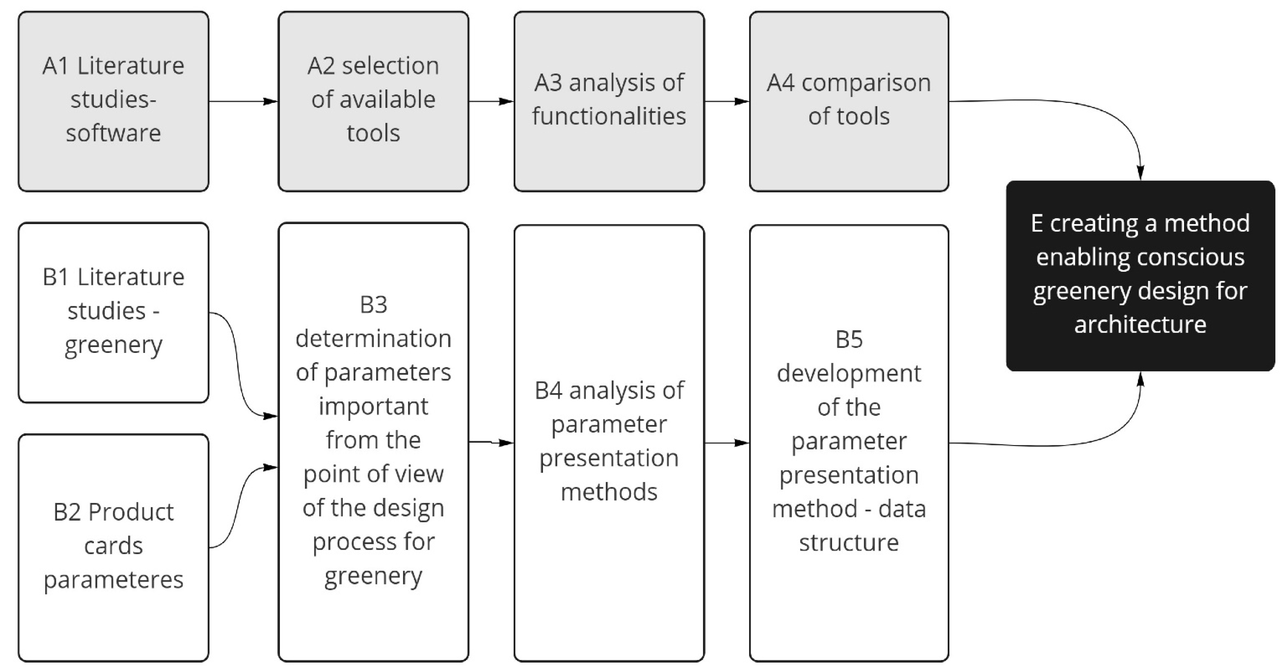
The work consists of two stages, starting with the review and investigation and recognition of software used in greenery design and characteristic parameters of greenery (Figure 1). The review of software functional capabilities in greenery design including plant selection, plant visual representation (two-dimensional and three-dimensional), characteristic parameters involvement, growth patterns, and more.
The investigation of greenery consists of a selection of criteria for the categorization of plants for creating data structures from which designers could benefit or that could become a database for semi-automated and automated systems. The research process is summarized with a new proposition for a complex digital method in the process of designing greenery that would involve all the necessary parameters involved in the greenery design process, that are not always fully considered, such as humidity or soil characteristics.
The software study is performed as a review of tools available for architects. The tools are rated in 10 categories crucial for the process of landscape design; in each one, a range of marks from 0 to 10 (integers) points is applied. The total number of points possible to achieve is 100 points. The classification should not be considered a direct comparison but rather an inside process of landscape design within them.
The proposed categories in this study involve manual landscape design, visual representation of greenery (two-dimensional and three-dimensional), the possibility of introducing plants to the library (introduction of the product card and its specified requirements), climatic data from external open sources (including EPW (EnergyPlus Weather Format), CLM (ESP-r weather format), WEA (Daysim weather format), and more), climatic analysis of the macro site (location, world directions, height, climate zone), sun hours analysis, airing analysis, simulation of growth and patterns–plants, selection of species (selection of species based on parameters) and automation of plant selection based on the selection of parameters.
The greenery literature study was performed with the reference to the recent publications that address the greenery selection process. This led to the determination of parameters important in the design process. Then, the analysis of possible greenery types and their parameters presentation methods were conducted. The study concluded with the development of possible parameters, presentation method, and data structure. The classification led to highlighting the most useful features in the matter of study in available software and a new proposition for a complex digital method in the process of designing greenery.
2.2. Review: Available Software Applied in Landscape Design
Digital tools have been used in the design industry for decades. They can complement, and, in some cases, completely replace traditional design procedures such as drawing, drafting, and modeling. Digital technologies increase the efficiency, speed, precision, and complexity of expressions in design. In addition to the basic functions provided by computer techniques, such as 2D drawing and 3D modeling, the programs offer many intelligent and complex functions that can improve the building and landscape design, building climate systems, and project material specifications to allow for better customization.
This section aims to assess the state of functionality of the software in the field of landscape design (Table 1). To determine the versatility of such programs, a set of functions was defined and tested for each program. The usefulness of programs to architects and landscape designs was measured by counting available program features. There are 4 main types of software in landscape design. As follows they are 2D graphic design software, CAD (Computer-aided design), BIM (Building Information Modeling), and visual algorithm platforms. The first group and the most basic one is 2D graphic design programs which are generally used for representation purposes. Designers often choose to develop their designs within this form of the digital environment, due to the ease of use. Such programs cannot properly test out schemes in 3D settings. The second type is CAD software that enables two-dimensional vector layout design and three-dimensional modeling. The third type is BIM-based software which is more complex and responsive. What distinguishes BIM from CAD is the information data included in the model. This allows for quantitative planning, bill of materials, and model coordination, and automates the process of creating documentation and visualization. The fourth group is visual algorithm software enabling an algorithmic approach to the process of design, which makes the design more flexible. It is based on a method of linking parameters and components that can be parametrized.
- -
- Adobe Photoshop for landscape design, is useful for graphic processing of visualizations and the creation of plans. This program does not have a specific function for this field, its tools are universal, which allows them to be used for many purposes. An example of such a solution could be the use of different brush shapes as symbols of plant species on the set.
- -
- Adobe Illustrator, similar to Photoshop, is a universal program in many design fields. It is useful for creating various types of graphics in vector format. It does not have landscape design features. In this field, a user can create, for example, land plans, and graphic symbols. It allows showing the project in an individual graphical style.
- -
- AutoCAD (and similar ZWCAD, GSTARCAD) is CAAD software aimed at architects, engineers, and construction professionals. It allows the creation of 2D drawings—from sketchy to precise design documentation. The program also enables 3D modeling. For landscaping, it offers a range of graphic symbols of trees and plants to be placed on the plan.
- -
- SketchUp is a 3D modeling program that is very intuitive and versatile; additionally, it has many useful features and add-ons for landscape designers. It gives the possibility of using geo-location, for example, to obtain a terrain model or study the sun setting. Objects of different kinds, for example, specific plant species, can be modeled from scratch or downloaded from the online library.
- -
- Rhinoceros is a CAAD program designed for precise 3D modeling. It gives the possibility to create any shape from small to large scale with the accuracy needed for design, prototyping, construction, analysis, and production. Additional collaborative software and plugins for design, drafting, CAM, engineering, analysis, rendering, animation, and illustration provide many possibilities in effects and project implementation. The Rhino software itself does not propose specific solutions for landscape designers.
- -
- Grasshopper was initially developed as a plug-in for Rhino, which is currently a part of Rhinoceros software. It is mainly used to create algorithms for parametric modeling of 3D geometry in conjunction with data analysis. The software allows for developing individual solutions for different fields of design such as production lighting performance analysis or building energy consumption. The visual language of the software provides an intuitive way to explore projects without having to learn a scripting language.
- -
- Landsdesign is strictly dedicated to landscape design. It enables 2D drafting, 3D modeling, and creating a visualization. Additionally, it allows the analysis and evaluation of landscape features. After modifying the site in the project, the program will show operations related to earthworks for execution purposes. To include vegetation in the project, you can use the database with over 1800 species that are represented in 2D and 3D elevations, which are conceptual, detailed, and realistic. Placed vegetation and other design elements detect the topography and are automatically placed on the ground. To find the appropriate plant species, you can use a filter that will adjust the search results based on the given characteristics.
- -
- 3ds Max offers a rich and flexible set of tools for creating projects. It gives the possibility of modeling interiors and 3D objects or even game characters and creating high-quality visualizations or animations. When focusing on the field of landscape design, proxy objects are a useful feature.
- -
- Revit is an example of a BIM program used in many design areas, mainly intended for architecture and engineering but also used in landscape design. The program allows the creation of a project throughout its cycle from conceptual design, visualization, and analysis to production and construction. It gives us the possibility of making 2D drawings, 3D models, documentation, and using data on objects. This allows for the automation of routine and repetitive tasks as well as precision in execution.
- -
- ArchiCAD, similar to Revit, is professional BIM software that offers an intuitive design environment, accurate information management, open collaboration, and automated documentation. It is used for the design and implementation of architectural projects using data analysis. It enables 3D modeling, documentation, and rendering of realistic visualizations.
- -
- LandFX is a BIM plug-in for landscape design targeted at software such as AutoCAD, SketchUp, and Rhino. The program allows the design of details, vegetation, and irrigation, creation of a 2D design by selecting symbols, plantings, and labels, and the actions are automated.
- -
- Vectorworks Landmark is a BIM program aimed at the professional landscape designer, offering project support from start to finish or at any stage. In total, 2D and 3D functions, visualizations, and project documentation are proposed. The program enables creative-free 3D modeling. There are many functions available in the subject of vegetation. Some of them, for example, have access to the species database in the default version, or it is possible to select a catalog from online resources. The designer can specify his expectations regarding the features of the species he wants to include in the project and the program will filter the database proposing a specific range. Plant objects are displayed in 2D and 3D and use parameters assigned by the user. The 3D representations can be schematic or photorealistic forms.
- -
- MicroStation is mainly intended for architectural and construction design. It is a 2D and 3D CAD program with the possibility of using BIM functions and parametric design. The available tools are universal for many design processes: from creating concepts, 2D documentation, and detailed BIM models to creating visualizations with the possibility of using geo-location and lighting analysis.
- -
- Dynascape is a CAD program created for landscape design, based mainly on the basic representative pillars with an emphasis on individual and effective presentation of the project: 2D drawings and documentation, graphic representation of the project, and 3D model and visualizations.
- -
- Lumion allows work between developing the detailed renders of your landscape architecture projects, and working in and updating your models in CAD or 3D modeling software. LiveSync works with all leading CAD programs including SketchUp, Revit, ArchiCAD, Rhino, Vectorworks, and AutoCAD. Going beyond the usual renders that intend to only convey some form of plant life, Lumion’s content library offers a large variety of vegetation, allowing you to create a scene that is richly detailed with specifically chosen nature and vegetation.
2.3. Review: Parameters of Greenery
The section aims to select the parameters that can be used in the model for the automated greenery design (AGD). The first step in the process is a general review of available plant databases applied in architectural software. The second step is evaluating applicability in the automatic selection and design process. The last step is an attempt to create a model of a primary parameter table-selected greenery parameters (SGP) that could become a base for a full greenery parameters table (FGP).
The programs used in the field of architecture contain databases with plant species for use in the project. From several hundred or several thousand species, you can choose the right plants based on your preferences. Each species in the database is described in more detail in some programs, less in others. Various characteristics are determined, such as appearance, height, spread, climatic zone, soil type, and others. In this chapter, the product sheets available in Landsdesign and Vectorworks Landmark will be analyzed. A proposal of what such a product card could look like is also shown in the BIM for Landscape study, which will also be analyzed in terms of its practicality and the possibility of the operation of such a card.
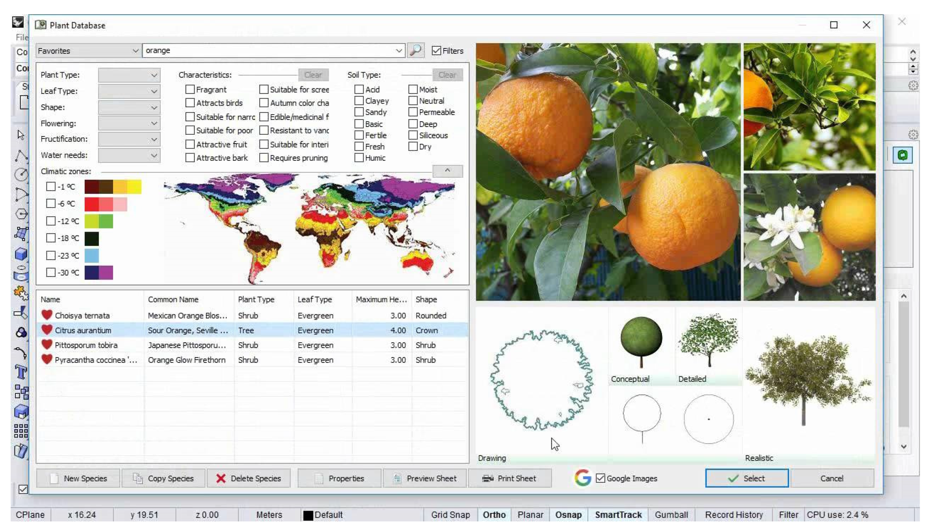
Landsdesign provides a plant database of over 1800 species. You can select a genre that fits your project by filtering the list according to various criteria, depending on your needs and expectations. To search for suitable species, you can select different characteristics in this topic: plant type, leaf type, shape, flowering, fructification, water needs, and climatic zones. In addition to these features, it is possible to select specific characteristics: fragrant, attracts birds, suitable for narrow streets, suitable for poor soil, attractive fruit, attractive bark, suitable for screen, autumn color change, edible/medicinal fruit, resistant to vandalism, suitable for interiors, requires pruning. It is also possible to determine the type of soil on which a given species is to grow: acid, clayey, sandy, basic, fertile, fresh, humic, moist, neutral, permeable, deep, siliceous, or dry. After selecting the desired traits, the list of species in the database narrows down to show only the ones that match. The product card of the selected species includes detailed photos, Latin and common names, information about the origin and family, and information about the requirements and application of the plant. The characteristics of the species define those features that could be marked in the search process: fragrance attracts birds, etc., shown as markers with some of these characteristics. The same applies to the type of soil. Additionally, information is presented (along with sample answers): pollution—high, marine environment—low, waterlogging—low, wind—low, plagues—high, sun—high. To represent the design, genres have different kinds of graphics, namely, 2D drawings for projection, simplified 3D conceptual shapes, detailed 3D shapes, and realistic 3D shapes for visualization purposes. Visual features such as height, span, density, and many others can be freely modified to suit your project. The main filters are plant type, leaf type, shape, flowering, water needs, soil type and individual needs (Figure 2).
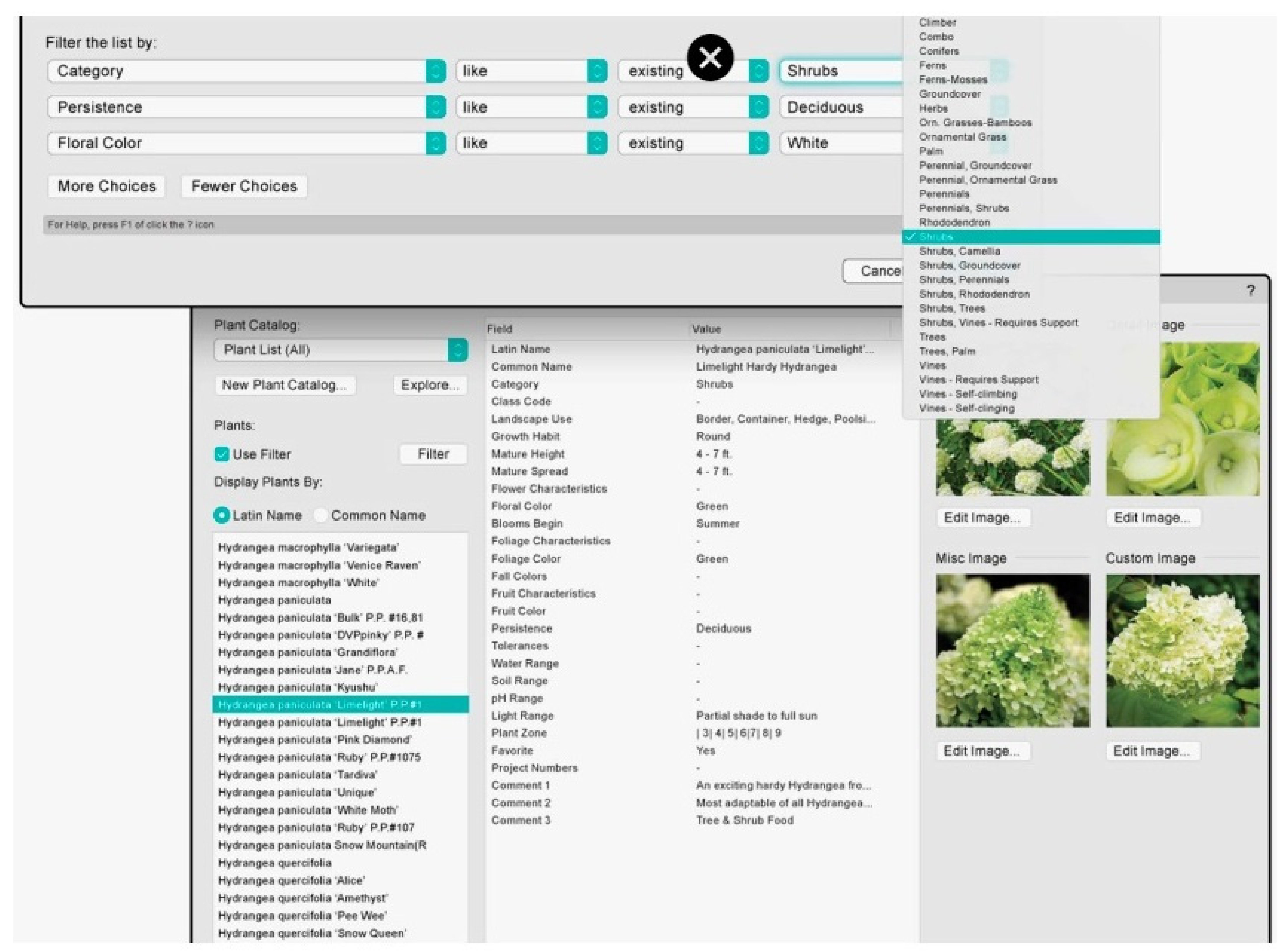
Vectorworks Landmark has its own species database as well as the ability to use catalogs from online resources. It is possible to search for suitable plants based on the given characteristics required by the project. Searchability is mainly based on category, persistence, and floral color. After selecting a specific species, a product card appears. It contains detailed photos of the plant and the following information: Latin name, common name, category, class code, landscape use, growth habit, mature height, mature spread, flower characteristics, floral color, blooms begin, foliage characteristics, foliage color, fall colors, fruit characteristics, fruit color, persistence, tolerances, water range, soil range, ph range, light range, plant zone, comments. Despite many detailed issues, the list does not contain all the information, for example, the required soil or irrigation. The main filters include category, persistence and floral color (Figure 3).
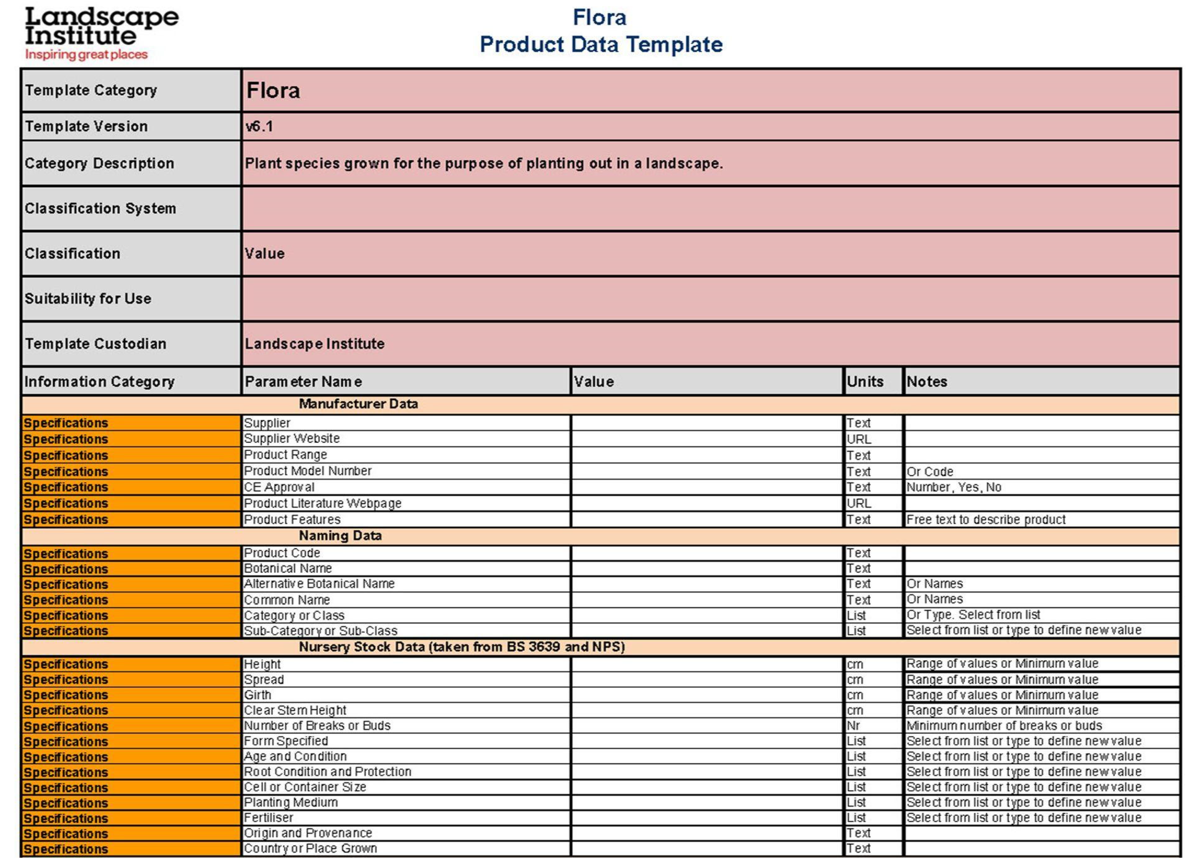
BIM for Landscape. The BIM for Landscape study presents a product sheet that could be a model for a detailed description of a given product. It contains several dozen terms that fall into several categories: main information, manufacturer data, naming data, nursery stock data, planting requirements, planting selection data, performance data, sustainability, operations and maintenance. Each of these categories includes several specific points. The data allow selection through manufacturer data, naming, nursery, planting requirements and selection data and maintenance (Figure 4).
The analysis of available greenery tables showed the necessity of creating a universal and simplified table that could become an open data source for the development of a system responsible for plant selection and a method of automated design. In the research process, the criteria and data content were established based on futures examined in the process of traditional plant selection. The outcome of the study is a selected greenery parameters (SGP) (Table 2) table consisting of two groups of data: basic information (Category, Gener, 3d Representation, 2d representation, Photo) and greenery properties (Height, Spread, Solar exposure, Moisture, Soil, Maintenance, Root volume, Temperature range, Life expectancy, Planting distance). The criteria selected in this part are useful for automated selection and automated design purposes.
3. Results
3.1. Theoretical Model of Computer-Aided Greenery Design
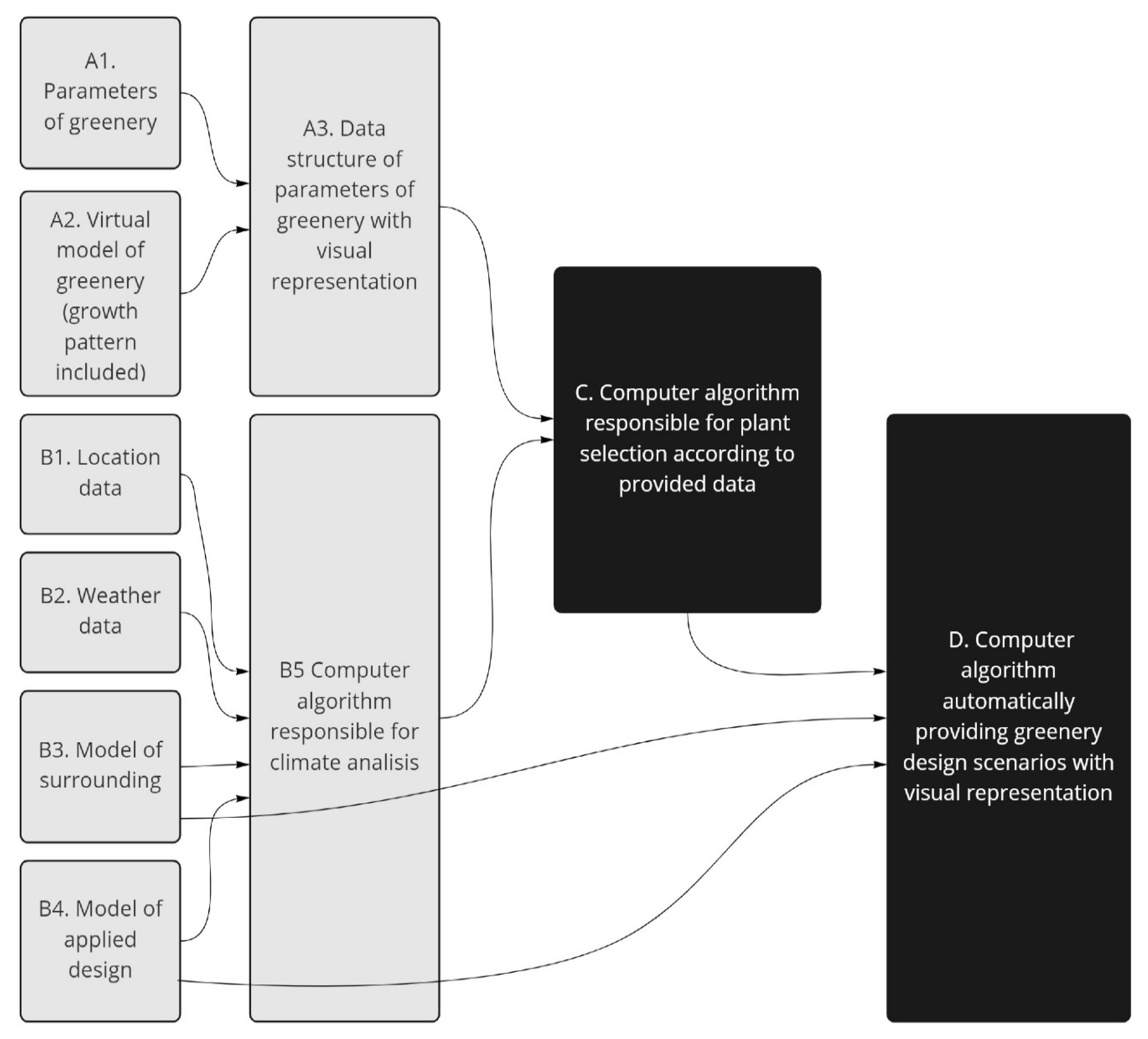
We can categorize the requirements related to the design of greenery, an example of which is the proposal of a universal tabular presentation of the requirements related to a given species, which is the result of the analysis of greenery parameters. The creation of a universal tabular form will constitute a database for the proposed computer system; however, is only the first step in the entire process. It is necessary to create a comprehensive catalog of plants that responds to the given issues and can be the subject of later computer-automated analyses (Figure 5).
The theoretical model is based on two sets of parameters—the first one consists of greenery characteristics which include parameters of greenery and virtual models of greenery (growth pattern included), resulting in the creation of data structure with the parameters of greenery and their visual representation. The second set considers design characteristic parameters and results in the creation of a computer algorithm responsible for climate analysis based on location data, weather data, model of surroundings, and a model of applied design. The two features enable the creation of computer algorithms responsible for plant selection according to provided data. The final step of the theoretical model is the computer algorithm automatically providing visual representation for greenery design scenarios.
The data necessary to conduct the analysis are divided into three groups. The first is the parameters and characteristics of plants, which will be developed in the simplified tabular form (SGP—selected greenery parameters) proposed by the authors, allowing for the assessment and verification of the applicability of a given species and the differences resulting from the growing process. The elements supporting the assessment and enabling the visual presentation of the species are also three-dimensional models and two-dimensional views.
The second group includes parameters and data related to the location and climatic data such as sun path, humidity, amount of precipitation, and climate. Appropriate data input and selection allows for accurate and necessary analyzes in the plant selection process to determine the requirements that must be met by species in a given place. However, the analysis cannot be carried out without the third data group consisting of the environment model and the designed object with elements of land development, which has a direct impact on, for example, the size of the possible root ball, humidity, or shading resulting from specific elements of land development.
In the next stage, the collected data are compiled and compared, which allows you to create a simulation related to the selection of the possibility of using given plant species in terms of the requirements related to the location of the project and its architectural dimension. The last, and at the same time the most advanced element of the proposed method, is a system proposing variants of the selection of vegetation for a given project, which may be the basis for further work.
3.2. Test Model for Single Scenario
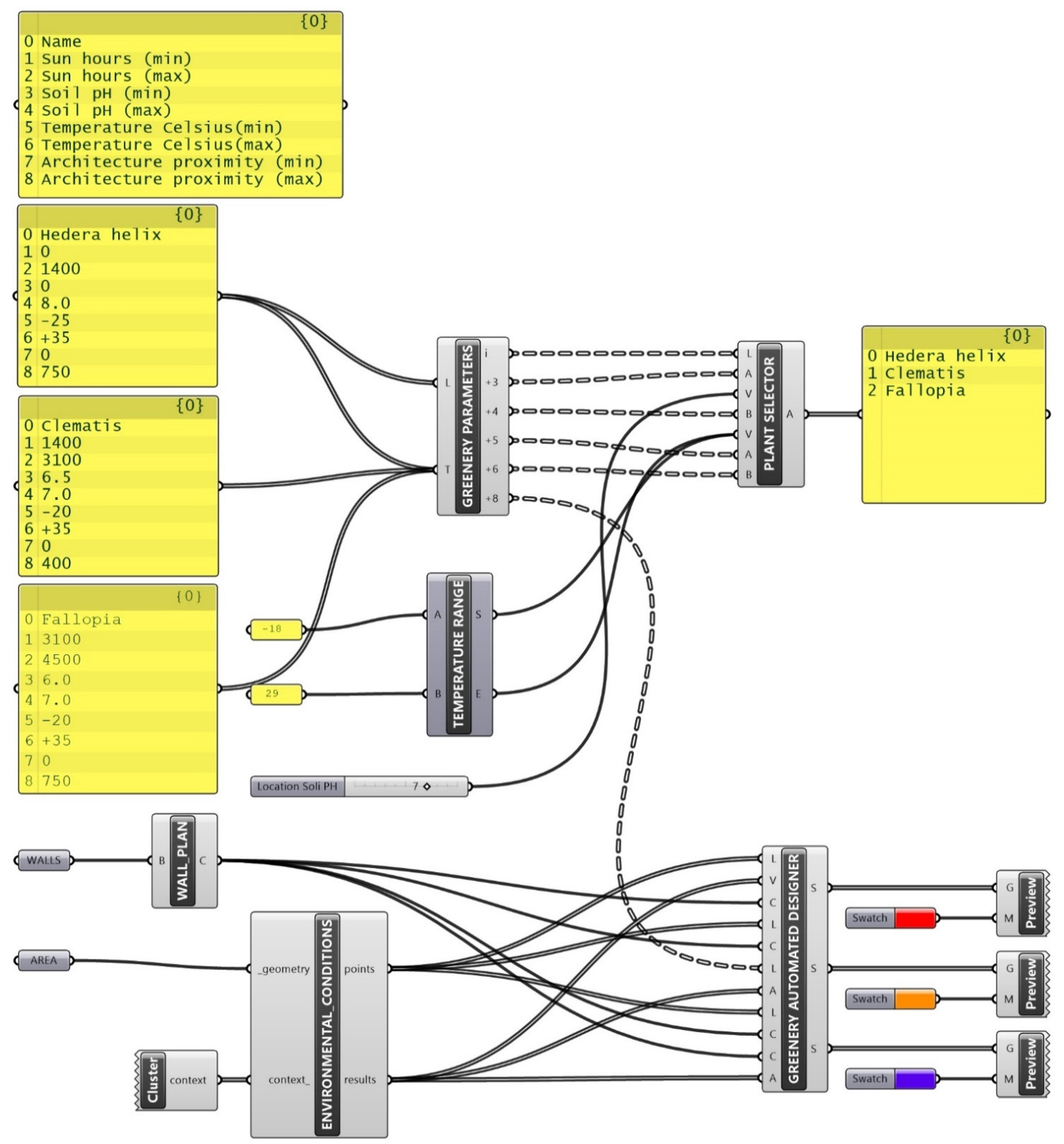
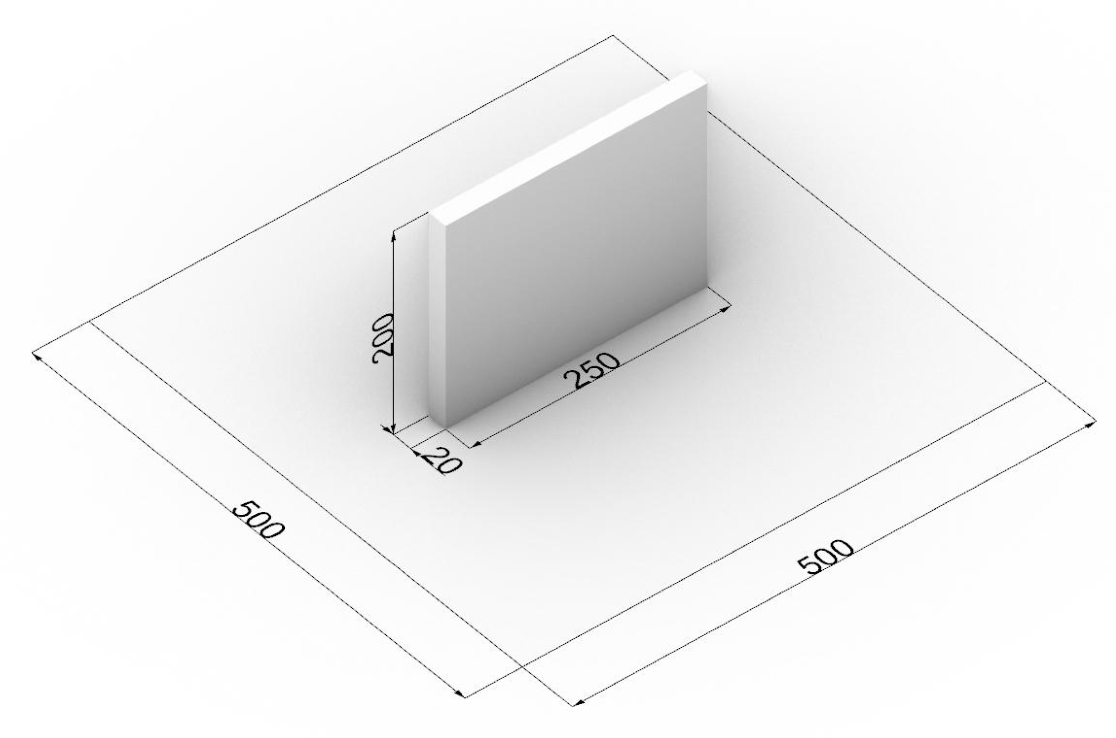
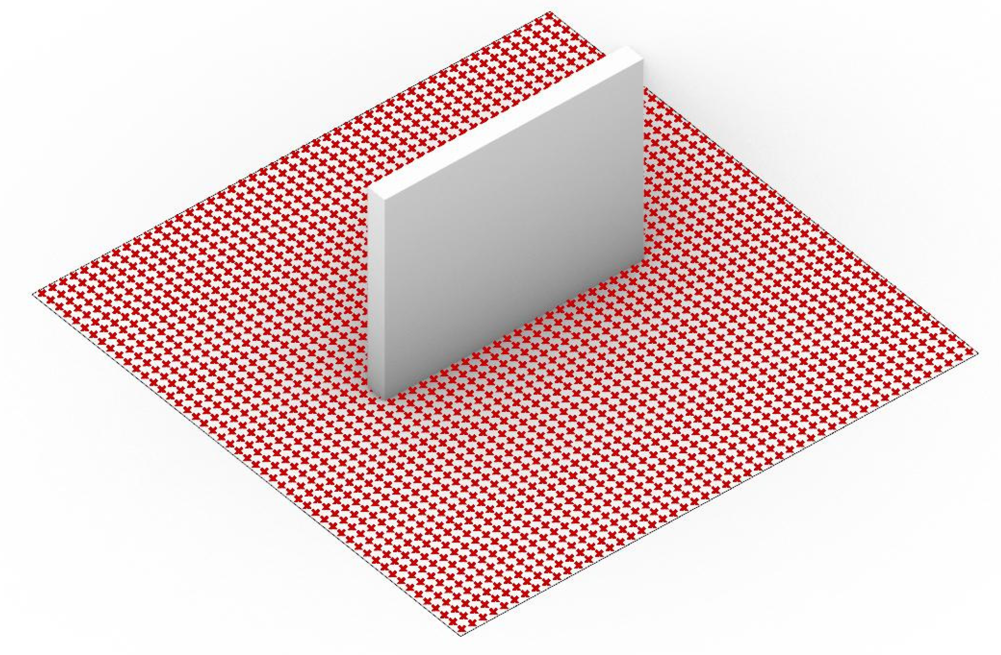
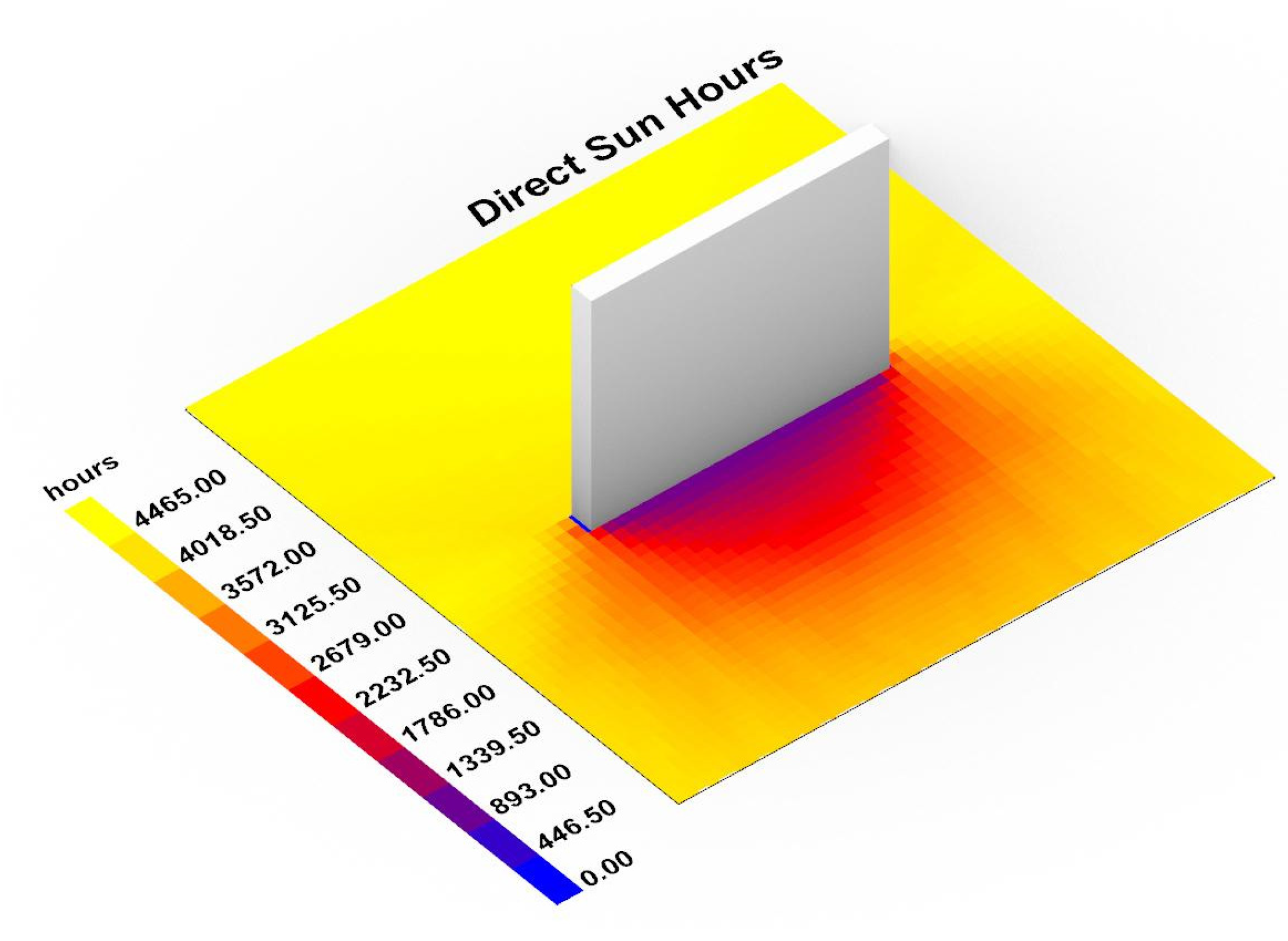
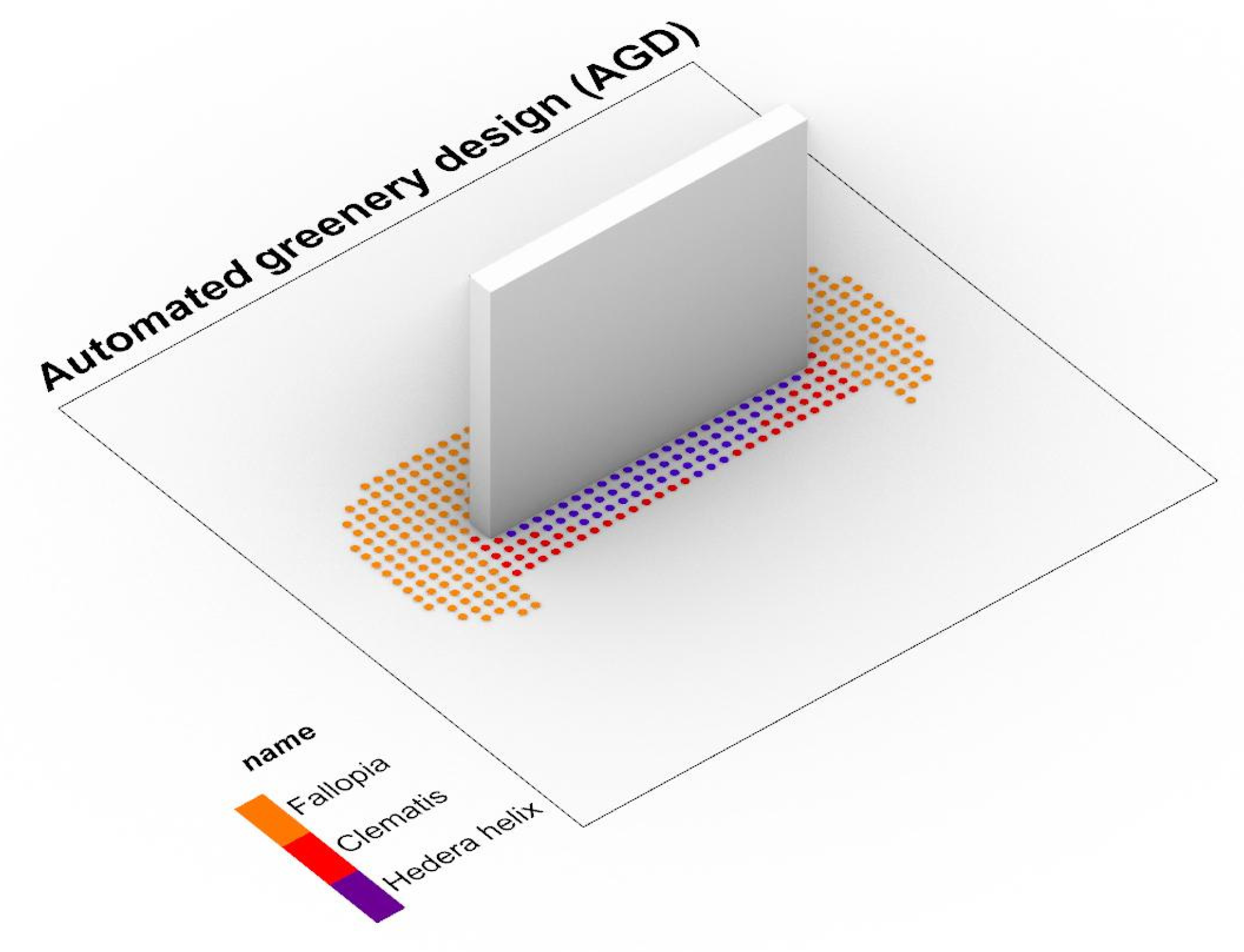
Checking the test model is an important stage that allows for the verification of the programming environment and the possibility of data presentation and the selection of basic criteria for generating spatial solutions. A test was carried out on a limited number of parameters and species to verify the possibility of creating an automated greenery designer (AGD). For this purpose, selected greenery parameters (SGP) were created for three selected species of vines: hedera helix, clematis, and fallopia (Table 3, Table 4 and Table 5), which constituted the basis for further research. The tables were made based on the available greenery parameters, which were unified and reduced to a given format. Then, on their basis, data lists were created directly in Rhinoceros using the Grasshopper (Figure 6). In parallel, a test spatial model limited to a simple environment was produced (Figure 7)— plane with dimensions of 500 × 500 cm and a cuboid with dimensions of 250 × 20 × 200 cm. Gdańsk in Poland was selected as the location, and the source of the weather data was the EnergyPlus Weather File (EPW) for the Northern Port in Gdańsk. The plane became the test area (Figure 8) for selected species.
The algorithm, in line with the assumptions made in the theoretical model, has been divided into two modules—the first one that allows determining the possibility of using a given plant and the second one that suggests its specific location. First, an algorithm module was programmed to verify the possibility of using a given species based on selected parameters such as soil type (pH), and annual temperature range. In the next step, a module was created that allowed for spatial analysis such as the number of sun hours (Figure 9) produced with the Ladybug plugin and the distance from the architectural object, based on which the algorithm selects and proposes the location of the species.
The conducted research indicated the possibility of using all 3 species in a given location. The automated greenery designer model suggested the optimal location for each of them in terms of the analyzed parameters. (Figure 10) The test model shows that the process can be automated and therefore based on mathematical criteria. The final solution should be evaluated and developed to take into account additional criteria that may be important for different situations and species. All of them can be described and tested with more complex solutions. The created model could become a useful tool for professionals allowing more control and better design decisions in the early design stages.
4. Discussion
Contemporary climate challenges are changing the architect’s awareness, which not only deals with the shell but also has to deal with greenery, which is the natural direction of expanding competencies. The available software enables the design of vegetation, but it is often very limited and requires specialist knowledge that goes beyond the competencies of the architect [42]. Most of the software available on the market allows the creation of proprietary solutions based on the creation of algorithms or writing scripts, but these are not currently common methods used in architecture and urban planning due to their high complexity [43,44]. Changing the method and introducing digital data-based systems will make architects keener to include green solutions at an early stage of projects and their solutions will be better adapted to the climate and requirements related to a given location [45,46].
One interesting issue also takes into account aspects related to fauna and their requirements, such as maintaining green corridors or maintaining biodiversity, which in turn strongly influence the development of greenery as a complete structure. Providing an appropriate environment for birds or insects in the city has a positive effect on the development of plant tissue and increases its importance in the entire ecosystem [47].
The currently proposed model is limited to selected parameters but in future research, the approach can be broadenedby the consideration of various environmental issues. For example, the impact of vegetation design parameters on air quality should be taken into account [48,49,50,51]. In particular, the aerodynamic and deposition effects of vegetation should be considered [52,53,54]. This can pertain to the selection of vegetation species most efficient in pollution deposition but also to selecting vegetation design characteristics so that it does not obstruct airflow, especially in densely built-up urban areas and street canyons [54,55,56]. In many cities, the scientific knowledge on these processes is already disseminated in the form of practical guidelines [57,58]. However, it is still not widespread among planners and designers and therefore not commonly applied in practice [48,59]. Therefore, design-support tools which facilitate the consideration of the impact of vegetation on local air quality, especially alongside other issues, are required.
The selection of plants should also consider such factors as the lifecycle of plants, the waste that is produced as well as the contribution of a specific type of greenery to the local CO2 balance. The design should also consider the three R’s concept (reduce, reuse, recycle) applied to the greenery as an important component of the architectural and urban project [60]. It is also crucial to develop the system for lifecycle management with a focus on environmental performance. In this matter, redevelopment of existing structures and strategies for heritage buildings should be considered with the availability to improve the analysis of existing buildings and their maintenance [28]. The new experience coming from the recent pandemic shows the need to include in future automated models for greenery design, factors related to the prevention of widespread diseases, peoples’ anxiety, social distancing intentions, cultural differences [61,62], healing properties of plants and their impact on peoples’ wellbeing.
It should be noted that BIM is a relatively new dynamically developing tool, about which there are not yet clearly defined boundaries of application. These boundaries are constantly being expanded to include more and more relationships between the built environment and the natural environment [63]. Our proposal makes it possible to improve the efficiency of greenery design by dynamically controlling important parameters that determine the environmental balance. It is a proposal for new applications of BIM with respect to Greenery design in landscape contexts.
The introduction of new tools and design methods should be supported by an increase in architects’ awareness of the importance of greenery and its impact on the comfort of use. In this context, it is also important to assess and analyze the impact of the entire project on the surroundings and the environment. This gives a chance to change the organization of the design process and make informed decisions not only in terms of the choice of greenery but the entire project.
The proposed computer method would allow for a more precise and knowledge-based design of greenery at the early stages of architectural design. The solution will require supplementation and consultation with a landscape architect, but it would constitute a good basis, supported by hard data, for the development of the concept at later stages of design. The proposed method could be a response to the often-complicated interface or redundant data provided at various stages of the work. The plant cards created for the system could consist of selected greenery parameters (SGP), taken into account during computer analyzes, but it could also include an additional full greenery parameters table (FGP) allowing for additional verification of special cases. In the authors’ opinion, creating cards and their variants is the greatest challenge, and an attempt to unify individual requirements may be a great research challenge.
5. Conclusions
Despite the continuous development of software in the field of architecture and urban planning, software in the field of greenery design does not propose advanced solutions for architects. The research indicates the necessity to propose a solution enabling conscious green design in a form available to architects. The proposed solution assumes the possibility of designing greenery at the early stages of an architectural design process with the use of automated plant selection and enabling the development of multiple scenario variations. Thanks to this, we can see the possibility of enabling the architect in the full design process, it has enabled comprehensive thinking about the location where architecture meets greenery. This offers a chance to organize the entire design process and make better decisions not only in terms of the choice of greenery but also the entire created structure.
In this context, Green BIM makes it possible to coordinate the most important components of an architectural project. These diagnostic factors—thanks to BIM technology—become available directly to designers, planners, investors and users. They make it possible to make design decisions supported by objectified measures from the early stages of design concepts. An important advantage of the proposed approach is the possibility of using simulation and evaluation based on BIM technology in greenery design.
Author Contributions
Conceptualization, D.S., J.C., W.B. and L.N.; methodology, D.S., J.C. and L.N.; software, D.S. and J.C.; validation, D.S. and J.C.; formal analysis, D.S., J.C., W.B. and L.N.; investigation, D.S., J.C., W.B. and L.N.; resources, D.S. and J.C.; data curation, D.S. and J.C.; writing—original draft preparation, D.S. and J.C.; writing—review and editing, D.S., J.C., W.B. and L.N.; visualization, D.S. and J.C.; supervision, J.C. and L.N.; funding acquisition, L.N. and W.B. All authors have read and agreed to the published version of the manuscript.
Funding
This research was funded by the European Union’s Horizon 2020 research and innovation programme under the Maria Skłodowska-Curie grant number 823901—sosclimatewaterfront—H2020-MSCA-RISE-2018. The APC was funded by Poznań University of Technology, Future City Lab 2022 programme under grant agreement No. 0111/SBAD/2209.
Institutional Review Board Statement
Not applicable.
Informed Consent Statement
Not applicable.
Data Availability Statement
Not applicable.
Conflicts of Interest
The authors declare no conflict of interest.
References
- Lynn, G.; Gage, M.F.; Nielson, S.; Rappaport, N. Composites, Surfaces, and Software: High Performance Architecture; Yale School of Architecture: New Haven, CT, USA, 2010; p. 104. [Google Scholar]
- Urbanowicz, K.; Nyka, L. Interactive and Media Architecture—From Social Encounters to City Planning Strategies. Procedia Eng. 2016, 161, 1330–1337. [Google Scholar] [CrossRef] [Green Version]
- Cudzik, J.; Radziszewski, K. Parametric design in architectural education. World Trans. Eng. Technol. Educ. 2019, 17, 448–453. [Google Scholar]
- Liao, L.; Zhou, K.; Fan, C.; Ma, Y. Evaluation of Complexity Issues in Building Information Modeling Diffusion Research. Sustainability 2022, 14, 3005. [Google Scholar] [CrossRef]
- Cameron, R.W.; Taylor, J.E.; Emmett, M.R. What’s ‘cool’ in the world of green façades? How plant choice influences the cooling properties of green walls. Build. Environ. 2014, 73, 198–207. [Google Scholar] [CrossRef] [Green Version]
- Abdel-Razek, S.A.; Marie, H.S.; Alshehri, A.; Elzeki, O.M. Energy Efficiency through the Implementation of an AI Model to Predict Room Occupancy Based on Thermal Comfort Parameters. Sustainability 2022, 14, 7734. [Google Scholar] [CrossRef]
- Gruber, P.; Imhof, B. Patterns of Growth—Biomimetics and Architectural Design. Buildings 2017, 7, 32. [Google Scholar] [CrossRef] [Green Version]
- Yi, H.; Yi, Y.K.; Chan, T. Performance Based Architectural design optimization: Automated 3D space Layout using simulated annealing. In Proceedings of the 2014 ASHRAE/IBPSA-USA Building Simulation Conference, Atlanta, GA, USA, 10–12 September 2014; pp. 292–299. [Google Scholar]
- Wu, G.; Miao, Y.; Wang, F. Intelligent Design Model of Urban Landscape Space Based on Optimized BP Neural Network. J. Sens. 2022, 2022, 9704287. [Google Scholar] [CrossRef]
- Li, C.Z.; Guo, Z.; Su, D.; Xiao, B.; Tam, V.W.Y. The Application of Advanced Information Technologies in Civil Infrastructure Construction and Maintenance. Sustainability 2022, 14, 7761. [Google Scholar] [CrossRef]
- Yokoi, K.; Fukuda, T.; Yabuki, N.; Motamedi, A. Integrating BIM, CFD and AR for Thermal Assessment of Indoor Greenery. In Proceedings of the 22nd International Conference on Computer-Aided Architectural Design Research in Asia (CAADRIA 2017), Suzhou, China, 5–8 April 2017. [Google Scholar] [CrossRef]
- Claypool, M.; Retsin, G.; Garcia, M.J.; Jaschke, C.; Saey, K. Automation and the Discrete: Exploring New Potentials for Streamlining Production in Architectural Design Research. J. Arch. Educ. 2021, 75, 108–114. [Google Scholar] [CrossRef]
- Badidi, E. Edge AI and Blockchain for Smart Sustainable Cities: Promise and Potential. Sustainability 2022, 14, 7609. [Google Scholar] [CrossRef]
- Weber, R.E.; Mueller, C.; Reinhart, C. Automated floorplan generation in architectural design: A review of methods and applications. Autom. Constr. 2022, 140, 104385. [Google Scholar] [CrossRef]
- Wong, N.H.; Tan, C.L.; Kolokotsa, D.D.; Takebayashi, H. Greenery as a mitigation and adaptation strategy to urban heat. Nat. Rev. Earth Environ. 2021, 2, 166–181. [Google Scholar] [CrossRef]
- Albers, M.; Deppisch, S. Resilience in the Light of Climate Change: Useful Approach or Empty Phrase for Spatial Planning? Eur. Plan. Stud. 2013, 21, 1598–1610. [Google Scholar] [CrossRef]
- Russo, A.; Cirella, G.T. Modern compact cities: How much greenery do we need? Int. J. Environ. Res. Public Health 2018, 15, 2180. [Google Scholar] [CrossRef] [Green Version]
- Brink, E.; Aalders, T.; Ádám, D.; Feller, R.; Henselek, Y.; Hoffmann, A.; Ibe, K.; Matthey-Doret, A.; Meyer, M.; Negrut, N.L.; et al. Cascades of green: A review of ecosystem-based adaptation in urban areas. Glob. Environ. Change 2016, 36, 111–123. [Google Scholar] [CrossRef]
- Nyka, L. From structures to landscapes-towards re-conceptualization of the urban condition. Archit. Res. Addressing Soc. Chall. 2017, 1, 509–515. [Google Scholar] [CrossRef]
- European Commission. Directive (EU) 2018/844 of the European Parliament and of the Council of 30 May 2018 Amending Directive 2010/31/EU on the Energy Performance of Buildings and Directive 2021/27/EU on Energy Efficiency; L156/75–91; European Commission (EU): Brussels, Belgium, 2018. [Google Scholar]
- Campiotti, C.A.; Gatti, L.; Campiotti, A.; Consorti, L.; De Rossi, P.; Bibbiani, C.; Muleo, R.; Latini, A. Vertical Greenery as Natural Tool for Improving Energy Efficiency of Buildings. Horticulturae 2022, 8, 526. [Google Scholar] [CrossRef]
- Hermansdorfer, M. BIM for Landscape. In Grading: BIM. landscapingSMART. 3D-Machine Control Systems. Stormwater Management; Birkhäuser: Berlin, Germany; Boston, MA, USA, 2019; pp. 213–220. [Google Scholar] [CrossRef]
- Shashua-Bar, L.; Potchter, O.; Bitan, A.; Boltansky, D.; Yaakov, Y. Microclimate modelling of street tree species effects within the varied urban morphology in the Mediterranean city of Tel Aviv, Israel. Int. J. Clim. 2009, 30, 44–57. [Google Scholar] [CrossRef]
- Picuno, C.A.; Godosi, Z.; Picuno, P. Implementing a Landscape Information Modelling (LIM) toolfor planning leisure facilities and landscape protection. In Proceedings of the Public Recreation and Landscape Protection—with Environment Hand in Hand: Conference Proceeding, Brno, Czech Republic, 9–10 May 2022; pp. 186–190. [Google Scholar] [CrossRef]
- Al Hattab, M.; Hamzeh, F. Simulating the dynamics of social agents and information flows in BIM-based design. Autom. Constr. 2018, 92, 1–22. [Google Scholar] [CrossRef]
- Bonenberg, W.; Rybicki, S.M.; Schneider-Skalska, G.; Stochel-Cyunel, J. Sustainable Water Management in a Krakow Housing Complex from the Nineteen-Seventies in Comparison with a Model Bio-Morpheme Unit. Sustainability 2022, 14, 5499. [Google Scholar] [CrossRef]
- Besir, A.B.; Cuce, E. Green roofs and facades: A comprehensive review. Renew. Sustain. Energy Rev. 2018, 82, 915–939. [Google Scholar] [CrossRef]
- Fernández-Mora, V.; Navarro, I.J.; Yepes, V. Integration of the structural project into the BIM paradigm: A literature review. J. Build. Eng. 2022, 53, 104318. [Google Scholar] [CrossRef]
- Chong, H.; Lee, C.; Wang, X. A mixed review of the adoption of Building Information Modelling (BIM) for sustainability. J. Clean. Prod. 2017, 142, 4114–4126. [Google Scholar] [CrossRef] [Green Version]
- Nyka, L.; Cudzik, J.; Urbanowicz, K. The CDIO model in architectural education and research by design. World Trans. Eng. Technol. Educ. 2020, 18, 85–90. [Google Scholar]
- Wei, X.; Bonenberg, W.; Zhou, M.; Wang, J. Application of BIM Simulation and Visualization in Landscape Architecture Design. Adv. Hum. Factors Archit. Sustain. Urban Plan. Infrastruct. 2020, 1214, 215–221. [Google Scholar] [CrossRef]
- Sanchez-Sepulveda, M.; Fonseca, D.; Franquesa, J.; Redondo, E. Virtual interactive innovations applied for digital urban transformations. Mixed approach. Future Gener. Comput. Syst. 2019, 91, 371–381. [Google Scholar] [CrossRef]
- Kamel, E.; & Memari, A.M. Review of BIM’s application in energy simulation: Tools, issues, and solutions. Autom. Constr. 2019, 97, 164–180. [Google Scholar] [CrossRef]
- Zanni, M.A.; Soetanto, R.; Ruikar, K. Towards a BIM-enabled sustainable building design process: Roles, responsibilities, and requirements. Arch. Eng. Des. Manag. 2016, 13, 101–129. [Google Scholar] [CrossRef] [Green Version]
- Walliss, J.; Rahmann, H. Landscape Architecture and Digital Technologies: Re-Conceptualising Design and Making, 1st ed.; Routledge: London, UK, 2016; pp. 216–217. [Google Scholar] [CrossRef]
- Wong, Y.C.; Chin, K.-Y. Plant Parameters Influencing the Cooling Performance of Vegetated Roofs: A review. Int. J. Sci. Res. Publ. 2018, 8. [Google Scholar] [CrossRef]
- Cantrell, B.; Mekies, A. (Eds.) Codify: Parametric and Computational Design in Landscape Architecture, 1st ed.; Routledge: London, UK, 2018; pp. 98–99. [Google Scholar] [CrossRef]
- Shu, Q.; Middleton, W.; Dörstelmann, M.; Santucci, D.; Ludwig, F. Urban Microclimate Canopy: Design, Manufacture, Installation, and Growth Simulation of a Living Architecture Prototype. Sustainability 2020, 12, 6004. [Google Scholar] [CrossRef]
- Clausen, R. BIM in Landscape Architecture: A Report. J. Digit. Landsc. Archit. 2021, 6, 353–369. [Google Scholar] [CrossRef]
- Wik, K.H.; Sekse, M.; Enebo, B.A.; Thorvaldsen, J. BIM for Landscape: A Norwegian Standardization Project. J. Digit. Landsc. Archit. 2018, 3, 241–248. [Google Scholar] [CrossRef]
- Fenby-Taylor, H. BIM for Landscape, 1st ed.; Routledge: London, UK, 2016. [Google Scholar] [CrossRef]
- Marzouk, M.; Ayman, R.; Alwan, Z.; Elshaboury, N. Green building system integration into project delivery utilising BIM. Environ. Dev. Sustain. 2021, 24, 6467–6480. [Google Scholar] [CrossRef]
- Kolarevic, B. (Ed.) Architecture in the Digital Age: Design and Manufacturing, 1st ed.; Taylor & Francis: Abingdon, UK, 2003. [Google Scholar] [CrossRef]
- Han, B.; Leite, F. Generic extended reality and integrated development for visualization applications in architecture, engineering, and construction. Autom. Constr. 2022, 140, 104329. [Google Scholar] [CrossRef]
- Keibach, E.; Shayesteh, H. BIM for Landscape Design Improving Climate Adaptation Planning: The Evaluation of Software Tools Based on the ISO 25010 Standard. Appl. Sci. 2022, 12, 739. [Google Scholar] [CrossRef]
- Ibrahim, Y.; Kershaw, T.; Shepherd, P. A methodology For Modelling Microclimates: A Ladybug-tools and ENVI-met verification study. In Proceedings of the 35th PLEA Conference. Planning Post Carbon Cities, A Coruña, Spain, 1–3 September 2020. [Google Scholar]
- Arévalo, C.; Amaya-Espinel, J.D.; Henríquez, C.; Ibarra, J.T.; Bonacic, C. Urban noise and surrounding city morphology influence green space occupancy by native birds in a Mediterranean-type South American metropolis. Sci. Rep. 2022, 12, 4471. [Google Scholar] [CrossRef] [PubMed]
- Badach, J.; Dymnicka, M.; Baranowski, A. Urban Vegetation in Air Quality Management: A Review and Policy Framework. Sustainability 2020, 12, 1258. [Google Scholar] [CrossRef] [Green Version]
- Badach, J.; Voordeckers, D.; Nyka, L.; Van Acker, M. A framework for Air Quality Management Zones-Useful GIS-based tool for urban planning: Case studies in Antwerp and Gdańsk. Build. Environ. 2020, 174, 106743. [Google Scholar] [CrossRef]
- Bottalico, F.; Chirici, G.; Giannetti, F.; De Marco, A.; Nocentini, S.; Paoletti, E.; Salbitano, F.; Sanesi, G.; Serenelli, C.; Travaglini, D. Air Pollution Removal by Green Infrastructures and Urban Forests in the City of Florence. Agric. Agric. Sci. Procedia 2016, 8, 243–251. [Google Scholar] [CrossRef] [Green Version]
- Baldauf, R. Roadside vegetation design characteristics that can improve local, near-road air quality. Transp. Res. Part D Transp. Environ. 2017, 52, 354–361. [Google Scholar] [CrossRef]
- Buccolieri, R.; Santiago, J.-L.; Rivas, E.; Sanchez, B. Review on urban tree modelling in CFD simulations: Aerodynamic, deposition and thermal effects. Urban For. Urban Green. 2018, 31, 212–220. [Google Scholar] [CrossRef]
- Janhäll, S. Review on urban vegetation and particle air pollution—Deposition and dispersion. Atmos. Environ. 2015, 105, 130–137. [Google Scholar] [CrossRef]
- Voordeckers, D.; Meysman, F.; Billen, P.; Tytgat, T.; Van Acker, M. The impact of street canyon morphology and traffic volume on NO2 values in the street canyons of Antwerp. Build. Environ. 2021, 197, 107825. [Google Scholar] [CrossRef]
- Xue, F.; Li, X. The impact of roadside trees on traffic released PM 10 in urban street canyon: Aerodynamic and deposition effects. Sustain. Cities Soc. 2017, 30, 195–204. [Google Scholar] [CrossRef]
- Buccolieri, R.; Gromke, C.; Di Sabatino, S.; Ruck, B. Aerodynamic effects of trees on pollutant concentration in street canyons. Sci. Total Environ. 2009, 407, 5247–5256. [Google Scholar] [CrossRef]
- Baldauf, R. Recommendations for Constructing Roadside Vegetation Barriers to Improve Near-Road Air Quality; 600/R-16/0; United States Environmental Protection Agency: Washington, DC, USA, 2016.
- Greater London Authority Using Green Infrastructure to Protect People from Air Pollution. Available online: https://www.london.gov.uk/WHAT-WE-DO/environment/environment-publications/using-green-infrastructure-protect-people-air-pollution (accessed on 5 August 2020).
- Badach, J.; Dymnicka, M.; Załęcki, J.; Brosz, M.; Voordeckers, D.; Van Acker, M. Exploring the Institutional and Bottom-Up Actions for Urban Air Quality Improvement: Case Studies in Antwerp and Gdańsk. Sustainability 2021, 13, 11790. [Google Scholar] [CrossRef]
- Johnny, W.K.W.; Zhou, J. Enchencing environmental sustainability over building life cycles through green BIM: A review. Autom. Constr. 2015, 57, 156–165. [Google Scholar]
- Qin, Z.; Song, Y. Symbol Matters: A Sequential Mediation Model in Examining the Impact of Product Design with Buddhist Symbols on Charitable Donation Intentions. Religions 2022, 13, 151. [Google Scholar] [CrossRef]
- Luo, J.; Zhang, Y.; Song, Y. Design for Pandemic Information: Examining the Effects of Grahps on Anxiety and Social Distancing Intention in the COVID-19. Front. Public Health 2022, 10, 800789. [Google Scholar] [CrossRef]
- Bonenberg, W.; Wei, X. Green BIM in Sustainable Infrastructure. Procedia Manuf. 2015, 3, 1654–1659. [Google Scholar] [CrossRef] [Green Version]
Figure 1.
Research method.

Figure 2.
Landsdesign plant selection.

Figure 3.
Vectorworks Landmark plant selection.

Figure 4.
BIM for Landscape product data template.

Figure 5.
Theoretical model of computer-aided greenery design-automated greenery design (AGD).

Figure 6.
Automated greenery design (AGD) test model created with Grasshopper for Rhinoceros.

Figure 7.
Test spatial model.

Figure 8.
Test area.

Figure 9.
Sun hours analysis with Ladybug.

Figure 10.
Sun hours analysis with Ladybug.


Table 1.
Comparison of available software applied in landscape design.
| Name | Manual Landscape Design | Visual Representation of Greenery | Plant Library | Climatic Data from External Sources | Climatic Analysis | Sunhours Analysis | Airing Analysis | Simulation of Growth | Selection of Species | Automatic Plant Selection | Result |
|---|---|---|---|---|---|---|---|---|---|---|---|
| Adobe Photoshop | + | + | − | − | − | − | − | − | − | − | 2/10 |
| Adobe Illustrator | + | + | − | − | − | − | − | − | − | − | 2/10 |
| AutoCAD | + | + | − | − | − | − | − | − | − | − | 2/10 |
| SketchUp | + | + | − | + | − | − | − | − | − | − | 3/10 |
| Rhinoceros | + | + | − | − | − | − | − | − | − | − | 2/10 |
| Grasshopper | + | + | + | + | + | + | + | + | + | − | 9/10 |
| Landsdesign | + | + | + | + | + | + | − | − | + | − | 7/10 |
| 3ds Max | + | + | + | − | − | − | − | − | − | − | 3/10 |
| Revit | + | + | + | + | − | + | − | − | + | − | 6/10 |
| ArchiCAD | + | + | + | + | − | − | − | − | − | − | 4/10 |
| LandFX | + | + | + | + | − | − | − | − | + | − | 5/10 |
| Vectorworks Landmark | + | + | + | + | + | − | − | − | + | − | 6/10 |
| MicroStation | + | + | + | − | − | − | − | − | − | − | 3/10 |
| Dynascape | + | + | + | − | − | − | − | − | − | − | 3/10 |
| Lumion | + | + | + | + | − | − | − | − | − | − | 4/10 |
Table 2.
Selected greenery parameters (SGP).
| Number | Name | Nursery | Grown | Type of Value | Unit |
|---|---|---|---|---|---|
| 1. | Category | text | - | ||
| 2. | Name | text | - | ||
| 3. | 3D Representation | brep | - | ||
| 4. | 2D representation | spline/point | - | ||
| 5. | Photo | image | - | ||
| 6. | Height | number domain | cm/inch | ||
| 7. | Spread | number domain | cm/inch | ||
| 8. | Solar exposure | number domain | Sun hours | ||
| 9. | Humidity | number | % | ||
| 10. | Soil | number domain | ph | ||
| 11. | Maintenance | 1–10 low-hight | 1–10 low-hight | number | integer |
| 12. | Root volume | number | Cubic meters | ||
| 13. | Temperature range | number domain | C/F | ||
| 14. | Life expectancy | number domain | integer | ||
| 15. | Planting distance | number | cm/inch | ||
| 16. | Architecture proximity | number domain | cm/inch |
Table 3.
Selected greenery parameters (SGP) for hedera helix.
| Number | Name | Nursery | Grown | Type of Value | Unit |
|---|---|---|---|---|---|
| 1. | Category | climber | climber | text | - |
| 2. | Name | Hedera helix | Hedera helix | text | - |
| 3. | 3d Representation | Violet dot | Violet dot | brep | - |
| 4. | 2d representation | Violet dot | Violet dot | spline/point | - |
| 5. | Photo |  |  | image | - |
| 6. | Height | 80 cm–120 cm | <30,000 cm | number domain | cm/inch |
| 7. | Spread | 10 cm–30 cm | <10,000 cm | number domain | cm/inch |
| 8. | Solar exposure | 0–1400 | 0–1400 | number domain | Sun hours |
| 9. | Humidity | 85% | 85% | number domain | % |
| 10. | Soil | <pH 8.0 | <pH 8.0 | number domain | ph |
| 11. | Maintenance | 2 | 1 | number | integer |
| 12. | Root volume | 0.3 m3 | 6 m3 | number | Cubic meters |
| 13. | Temperature range | (−25)–(+35) | (−25)–(+35) | number domain | C/F |
| 14. | Life expectancy | 500 years | 500 years | number domain | integer |
| 15. | Planting distance | 200 cm | 500 cm | number | cm/inch |
| 16. | Architecture proximity | 0 cm–75 cm | 0 cm–500 cm | number domain | cm/inch |
Table 4.
Selected greenery parameters (SGP) for clematis.
| Number | Name | Nursery | Grown | Type of Value | Unit |
|---|---|---|---|---|---|
| 1. | Category | climber | climber | text | - |
| 2. | Name | Clematis | Clematis | text | - |
| 3. | 3d Representation | Red dot | Red dot | brep | - |
| 4. | 2d representation | Red dot | Red dot | spline/point | - |
| 5. | Photo |  |  | image | - |
| 6. | Height | 80 cm–120 cm | <10,000 cm | number domain | cm/inch |
| 7. | Spread | 10 cm–30 cm | <6000 cm | number domain | cm/inch |
| 8. | Solar exposure | 1400–3100 | 1400–3100 | number domain | Sun hours |
| 9. | Humidity | 75% | 75% | number domain | % |
| 10. | Soil | pH 6.5–pH 7.0 | pH 6.5–pH 7.0 | number domain | ph |
| 11. | Maintenance | 4 | 3 | number | integer |
| 12. | Root volume | 0.3 m3 | 2 m3 | numer | Cubic meters |
| 13. | Temperature range | (−20)–(+35) | (−20)–(+35) | number domain | C/F |
| 14. | Life expectancy | <100 years | <100 years | number domain | integer |
| 15. | Planting distance | 150 cm | 300 cm | number | cm/inch |
| 16. | Architecture proximity | 0 cm–40 cm | 0 cm–75 cm | number domain | cm/inch |
Table 5.
Selected greenery parameters (SGP) for clematis.
| Number | Name | Nursery | Grown | Type of Value | Unit |
|---|---|---|---|---|---|
| 1. | Category | climber | climber | text | - |
| 2. | Name | Fallopia | Fallopia | text | - |
| 3. | 3d Representation | Orange dot | Orange dot | brep | - |
| 4. | 2d representation | Orange dot | Orange dot | spline/point | - |
| 5. | Photo |  |  | image | - |
| 6. | Height | 80 cm–120 cm | <12,000 cm | number domain | cm/inch |
| 7. | Spread | 10 cm–30 cm | <8000 cm | number domain | cm/inch |
| 8. | Solar exposure | 3100–4500 | 3100–4500 | number domain | Sun hours |
| 9. | Humidity | 70% | 70% | number domain | % |
| 10. | Soil | pH 6.0–pH 7.0 | pH 6.0–pH 7.0 | number domain | ph |
| 11. | Maintenance | 4 | 3 | number | integer |
| 12. | Root volume | 0.3 m3 | 4 m3 | numer | Cubic meters |
| 13. | Temperature range | (−20)–(+35) | (−20)–(+35) | number domain | C/F |
| 14. | Life expectancy | <100 years | <100 years | number domain | integer |
| 15. | Planting distance | 200 cm | 400 cm | number | cm/inch |
| 16. | Architecture proximity | 0 cm–75 cm | 0 cm–200 cm | number domain | cm/inch |
Publisher’s Note: MDPI stays neutral with regard to jurisdictional claims in published maps and institutional affiliations. |
© 2022 by the authors. Licensee MDPI, Basel, Switzerland. This article is an open access article distributed under the terms and conditions of the Creative Commons Attribution (CC BY) license (https://creativecommons.org/licenses/by/4.0/).
Share and Cite
MDPI and ACS Style
Sędzicki, D.; Cudzik, J.; Bonenberg, W.; Nyka, L. Computer-Aided Automated Greenery Design—Towards a Green BIM. Sustainability 2022, 14, 8927. https://0-doi-org.brum.beds.ac.uk/10.3390/su14148927
AMA Style
Sędzicki D, Cudzik J, Bonenberg W, Nyka L. Computer-Aided Automated Greenery Design—Towards a Green BIM. Sustainability. 2022; 14(14):8927. https://0-doi-org.brum.beds.ac.uk/10.3390/su14148927
Chicago/Turabian StyleSędzicki, Dominik, Jan Cudzik, Wojciech Bonenberg, and Lucyna Nyka. 2022. "Computer-Aided Automated Greenery Design—Towards a Green BIM" Sustainability 14, no. 14: 8927. https://0-doi-org.brum.beds.ac.uk/10.3390/su14148927
Note that from the first issue of 2016, this journal uses article numbers instead of page numbers. See further details here.