Article

Developing the Urban Blue-Green Infrastructure as a Tool for Urban Air Quality Management

1
Department of Urban Architecture and Waterscapes, Faculty of Architecture, Gdańsk University of Technology, 11/12 Narutowicza Street, 80-233 Gdańsk, Poland
2
Department of History, Theory of Architecture and Conservation of Monuments, Faculty of Architecture, Gdańsk University of Technology, 11/12 Narutowicza Street, 80-233 Gdańsk, Poland
3
Institute of Architecture and Spatial Planning, Faculty of Architecture, Poznań University of Technology, 2 Jacka Rychlewskiego Street, 61-131 Poznań, Poland
4
Department of Process Engineering and Chemical Technology, Faculty of Chemistry, Gdańsk University of Technology, 11/12 Narutowicza Street, 80-233 Gdańsk, Poland
*
Author to whom correspondence should be addressed.
Sustainability 2022, 14(15), 9688; https://0-doi-org.brum.beds.ac.uk/10.3390/su14159688
Submission received: 30 June 2022 / Revised: 28 July 2022 / Accepted: 31 July 2022 / Published: 6 August 2022

Abstract

:
Urban structure is an important factor that shapes the process of urban ventilation and pollution dispersion. With proper planning of the urban spatial layout, city breathability can be effectively regulated, contributing to urban air quality improvement. This paper investigates the development and current management of urban systems of green and open spaces in four Polish cities: Gdańsk, Warsaw, Poznań and Wrocław, with a particular focus on the planning aspects of urban ventilation and air quality management. The initial GIS-based comparison of historical plans and the current spatial layouts of the cities show that these systems, consciously shaped at the beginning of the twentieth century, remain clearly identifiable. However, in some locations, the continuance of these systems was interrupted by later investments. The next step was to develop GIS procedures to effectively map the spatial distribution of selected urban form indicators that are related to urban ventilation, especially the frontal area index. The results made it possible to determine the main features of the current ventilation systems and to identify some of the local problem areas. The last phase of the study was to conduct a local-scale analysis of these problem areas. With this study, the applicability of various analysis and simulation tools for the purpose of improving city breathability by appropriate integrated planning and design decisions was demonstrated. The presented approach, taking into account the city- and micro-scale interactions, should be used in current planning practice to preserve the historically developed ventilation systems.

1. Introduction

It is estimated that over four million people worldwide die prematurely every year as a result of exposure to outdoor air pollution. Almost all the global population breathes air that does not meet the World Health Organization (WHO) standards [1]. Being listed among the 10 major threats to global health, air pollution and the strategies for its mitigation are high on the worldwide agenda [1,2]. Although in Europe, air pollution emissions have been reduced in the past several years due to the implementation of many policies, such as the development of sustainable transport systems, a significant proportion of European residents still live in places where the pollutant levels are above the set standards [3]. In Poland, environmental and air quality management is particularly ineffective in comparison to many European Union (EU) countries [3,4].
The process of urban ventilation affects air pollution dispersion and, thus, contributes to air quality improvement. Urban ventilation efficiency, in turn, is significantly affected by urban structure [5,6,7]. This aspect should be comprehensively integrated into urban planning [8,9,10,11]. The consideration of urban airflow in relation to the spatial characteristics of urban form should follow the integration of different urban scales—see Figure 1. At On the scale of the entire city, or even on a regional scale, urban ventilation corridors should be designated and preserved to improve air exchange between the polluted city centre and the surrounding areas [6,12,13,14,15,16]. On the neighbourhood scale, the appropriate layout of the urban blocks can ensure the development of secondary ventilation pathways, ideally being connected with the main ventilation corridors [9,10,17]. Moreover, not only the 2D spatial configuration but also the three-dimensional structure should be considered in relation to effective airflow within the urban built environment [18,19,20,21,22,23]. Finally, on a local scale, the orientation of buildings and open spaces, their configurations and the typology of building complexes in relation to the local wind environment can be also analysed [24,25,26,27,28,29]. Such a comprehensive approach toward urban air quality and ventilation management is consistent with the recommended practice for scale-sensitive integration in urban planning [30,31] and environmental management [32,33].
Improving urban ventilation efficiency contributes not only to air quality improvement but also mitigates the urban heat island (UHI) effect. The UHI is the effect of an increase in ground-level atmospheric temperature within a city, relative to the air temperature outside the city. It was first identified at the beginning of the nineteenth century in London and was subsequently reported in other industrial cities [34]. Depending on the structure of the city, the heat island takes different spatial forms. The general pattern is an increase in temperature from suburban areas to dense urban centres, where temperatures reach a maximum. The UHI is the result of changes in the land use of urbanised areas. Such changes distort the natural state of urban climates, making them much warmer than rural climates. As studies show, the UHI effect intensifies under conditions of low wind speed [35]. This is confirmed by meteorological observations that indicate that urban climates are warming due to disturbed airflow mechanisms, as a result of tall and densely situated buildings [36]. These observations reveal that above certain wind speeds, the UHI is significantly reduced. This situation occurs in well-ventilated areas with low building heights [37].
Inquiries into how urban planning may contribute to healthier cities and improve urban air quality began to appear in the nineteenth century. The idea was that certain designated areas should remain natural and allow unobstructed airflow—providing clean air and blowing pollutants away. Such concepts as John Claudius Loudon’s plans for green belts for London, the idea of the Garden City developed by Ebenezer Howard, waterside parks by Frederick Law Olmsted and many other schemes were developed in response to the poor quality of life in industrial cities. Today, the pursuit of making cities more sustainable, healthier, more closely related to nature and resilient to climate change has triggered diversified research studies on the policies and instruments that are necessary to control urban transformations [38,39,40,41]. The availability of advanced digital tools and complex databases opens new paths toward developing innovative methods of investigation into the effectiveness of urban ventilation.
The planning aspects of the development and maintenance of urban ventilation systems in four Polish cities (Gdańsk, Poznań, Warsaw and Wrocław) were addressed in this research. The aim was to trace how the current systems of green and open spaces in these cities were shaped by their historical spatial development. Geographic information system (GIS) tools were then used to assess the degree of preservation and to identify the current features of the ventilation systems in these cities. Mapped urban form indicators were also used to identify local problem areas, in which alternative design solutions should be applied to avoid inhibiting the ventilation process. Finally, it was demonstrated that the sensitivity of GIS-based analysis on the city scale is not sufficient to identify all the spatial issues related to reduced ventilation efficiency. On the contrary, after a preliminary GIS analysis is completed, further investigation of the local urban layout is required. Moreover, computational fluid dynamics (CFD) simulations should be used on the local scale to fully understand how urban planning and design decisions can impact the efficiency of the ventilation process at the local level.

2. Materials and Methods
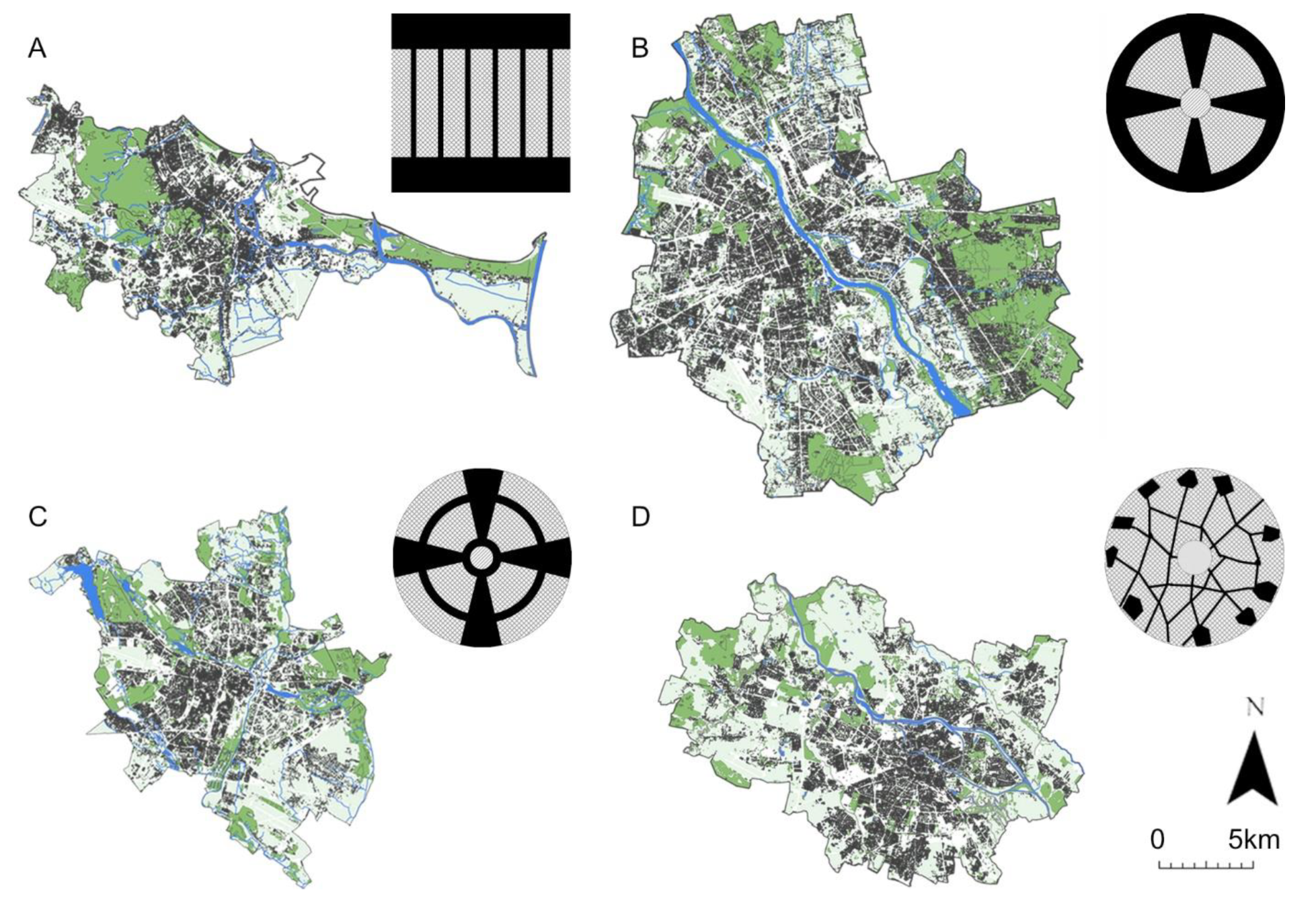
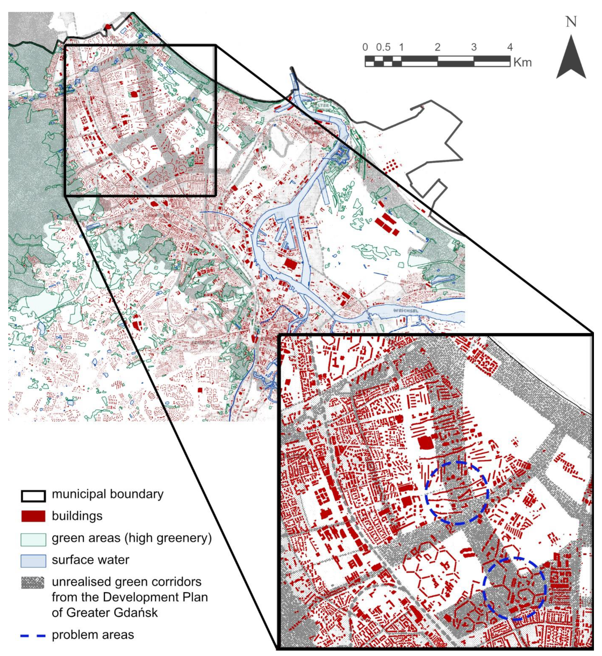
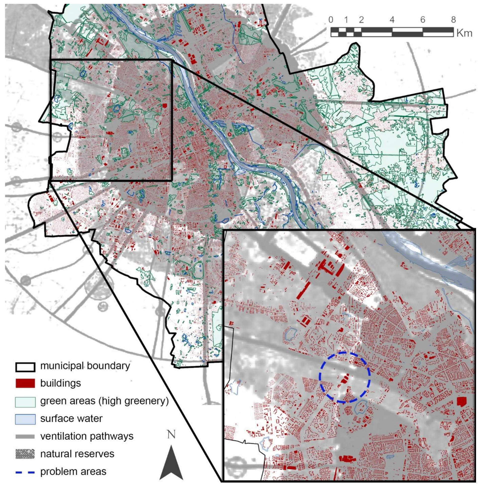
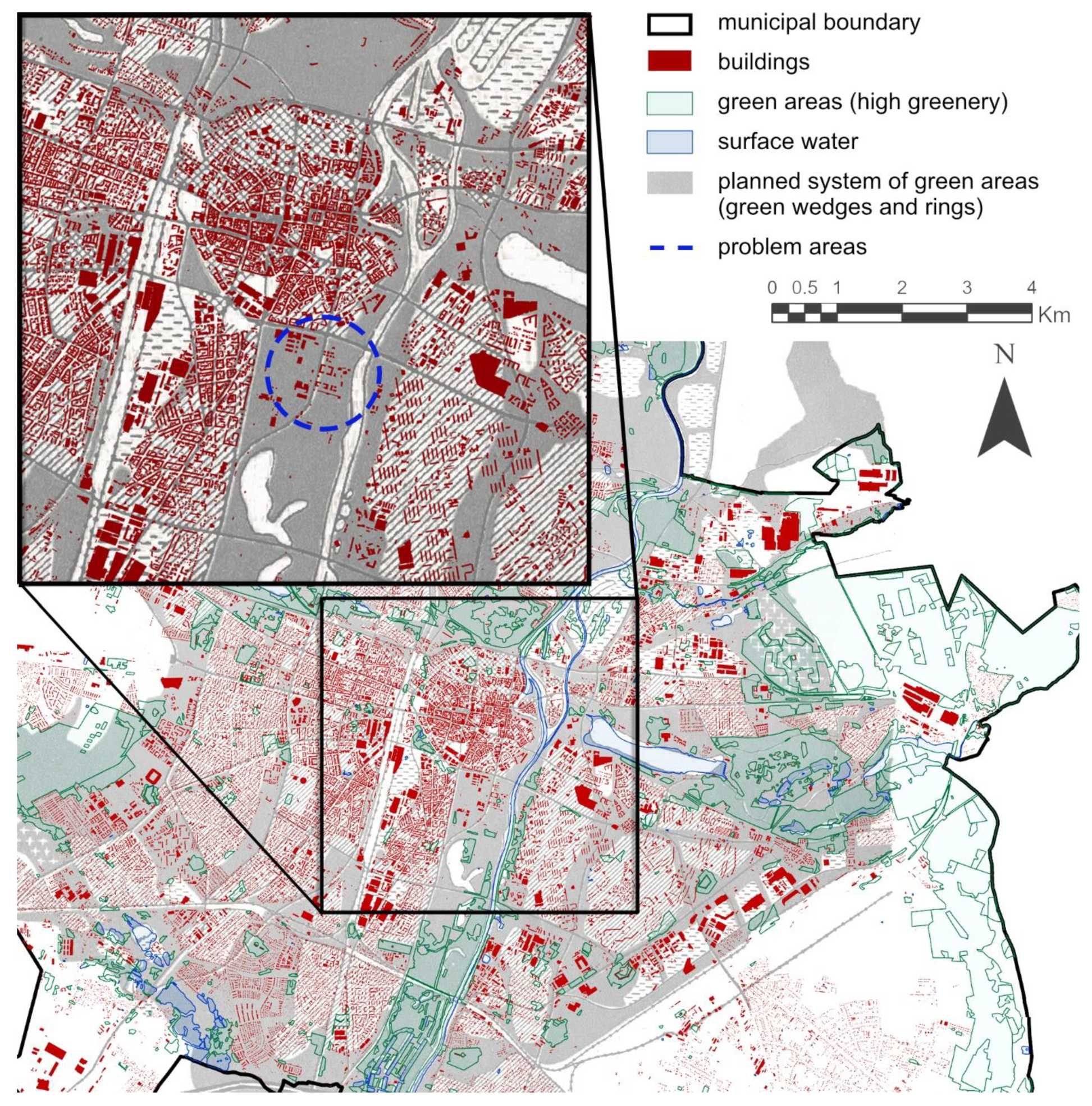
2.1. Study Areas

Four municipalities were selected for the study: Gdańsk, Warsaw, Poznań and Wrocław. Gdańsk (54.35° N, 18.65° E), a city on the Baltic coast and the largest in the Pomeranian Voivodeship, incorporates the largest Polish seaport. Poznań (52.41° N, 16.92° E), a city on the Warta River, in west-central Poland, is the fifth-largest city in Poland, in terms of population. Warsaw (52.23° N, 21.01° E), located on the Vistula River, is the capital city and the largest city in Poland. Wrocław (51.11° N, 17.04° E), a city in southwestern Poland on the Odra River, is the fourth most populated city in Poland.
The cities are largely of comparable size: Gdańsk has an area of 262 square kilometres and a population of 470,621; Poznań has an area of 262 square kilometres and a population of 529,410; Warsaw has an area of 517 square kilometres and a population of 1,795,569; Wrocław has an area of 293 square kilometres and a population of 642,687 [42,43]. However, they exhibit heterogenic parameters in terms of topography, urban morphology, the distribution of built-up structures, land use, and vegetation systems. In particular, these cities have distinctive ventilation systems. These systems began to be consciously shaped at the beginning of the twentiethcentury.
In Gdańsk, the first modern urban plan covering the entire city was not developed until 1929–1930. It was the Development Plan of Greater Gdańsk (German: Bebauungsplan Groß-Danzig)—see Figure 2. Its authors were Hugo Althoff, Karl Fehlhaber, and Karl Hell [44]. Part of this plan was the green system plan (Grünflächenplan). The essence of the solution was the creation of two green belts—forests on hills, with post-fortification areas and seaside parks. These belts were to be connected by wedges of greenery stretching along the streams. In the plans developed in the 1930s, the green system project proposed by Althoff was partially continued; however, some original assumptions were abandoned [45].
In 1916, a group of architects, led by Tadeusz Tołwiński, created the “Sketch of the preliminary regulatory plan of Warsaw” [46]. Green wedges appeared in this project, which were to perform hygienic functions and at the same time constitute the framework for the future development of the city as a radial structure [47]. In 1931, the “General Plan of Greater Warsaw for 3 million inhabitants” made by Stanisław Różański’s group was finally approved. Work on this document took several years, but the basic assumptions were published as early as 1928 [48]. In the “General Plan”, the concept of green wedges was developed. These consist of areas covering four categories: the Vistula valley, parks and sports grounds, cemeteries and “reserves”, i.e., garden and agricultural areas where building is prohibited [49]—see Figure 3. Green wedges connect to the green insulation strip surrounding the entire city. The authors of the plan emphasised the particular importance of the river valley for the ventilation of the city. They also pointed out the treatment of cemeteries as an essential element of the ecosystem, which is consistent with contemporary research [50].
In 1903, Josef Stübben prepared the first of a series of detailed development and zoning plans for Poznań. These plans were modified and supplemented over the next 10 years. In Stübben’s plans, the green system was formed by three half-rings surrounding the city centre , supplemented by radial bands along the river valleys. Stübben’s plans in the 1930s were further developed by Władysław Czarnecki and his Town Planning Studio of the City of Poznań [51]. A consistent, coherent radial-radial green system was created, and the overall green area in Poznań increased significantly during the 20th century [52]. Initially, 10 wedges were proposed by Czarnecki in his plan from 1932—as depicted in Figure 4—but their number was reduced to 4 main wedges in subsequent municipal plans [53].
From 1921 to 1922, an urban competition was held in Wrocław, the aim of which was to re-organise the existing city and create a spatial framework for future development. The winner of the competition was the architect and town planner, Ernst May, acting in cooperation with Herbert Boehm [54]. May believed that the previously used concentric city systems and the more modern radial city system with green wedges were not appropriate solutions to the problem of providing access to greenery. The architect proposed a project called Trabanten (“satellites” in German)—see Figure 5. The city was to be decentralised, meaning that the urbanised central city zone would be surrounded by self-sufficient satellite housing estates. The boundaries between the estates would be fixed using urban greenery [55,56].
The political changes that took place after the Second World War broke the continuity of urban planning in two of the analysed cities. Wrocław and Gdańsk ceased to belong to Germany; there was an almost complete replacement of the population in these cities. The conflict of national identities meant that the architectural past of these cities was negated [58]. Urban concepts that were developed before 1945 had no continuators. The situation was different in Warsaw and Poznań, where the Polish designers of urban plans continued their work and where the implementation of green and ventilation systems that were designed in the 1930s continued. However, nowadays, insufficient planning provisions to protect these systems and pressure from developers have led to their degradation [59,60]. The current configuration of these systems and the initial planning concepts that shaped them are shown in Figure 6.
Air quality is monitored within the four cities on a daily basis: in Gdańsk by the ARMAAG Foundation [63], and in Warsaw, Poznań and Wrocław by the WIOŚ environmental authority (Voivodeship Inspectorate of Environmental Protection) [64,65,66]. Air quality is also modelled and estimated in various studies on the municipal scale with the use of dispersion models (see, e.g., [67,68,69]). However, so far, the research into the existing urban structure and planning policies with respect to urban ventilation and air quality monitoring is still insufficient.

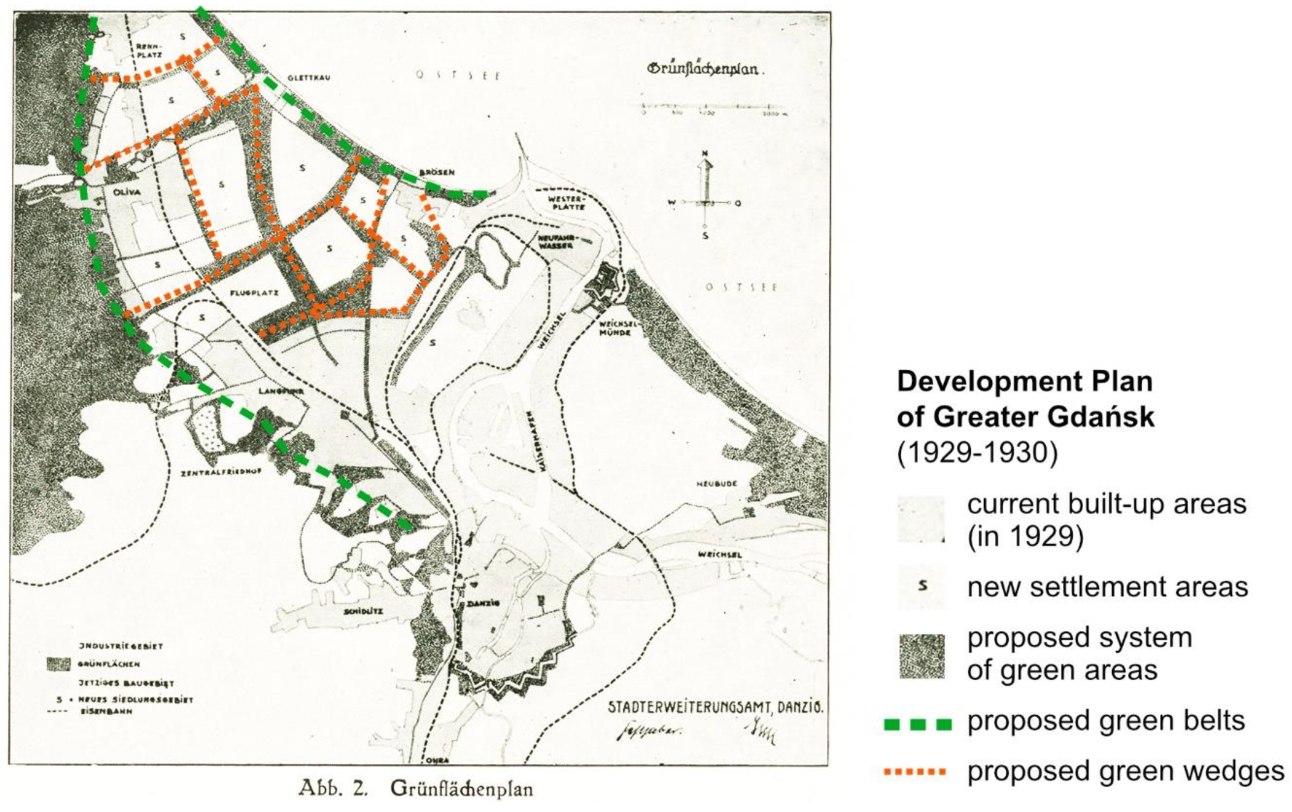
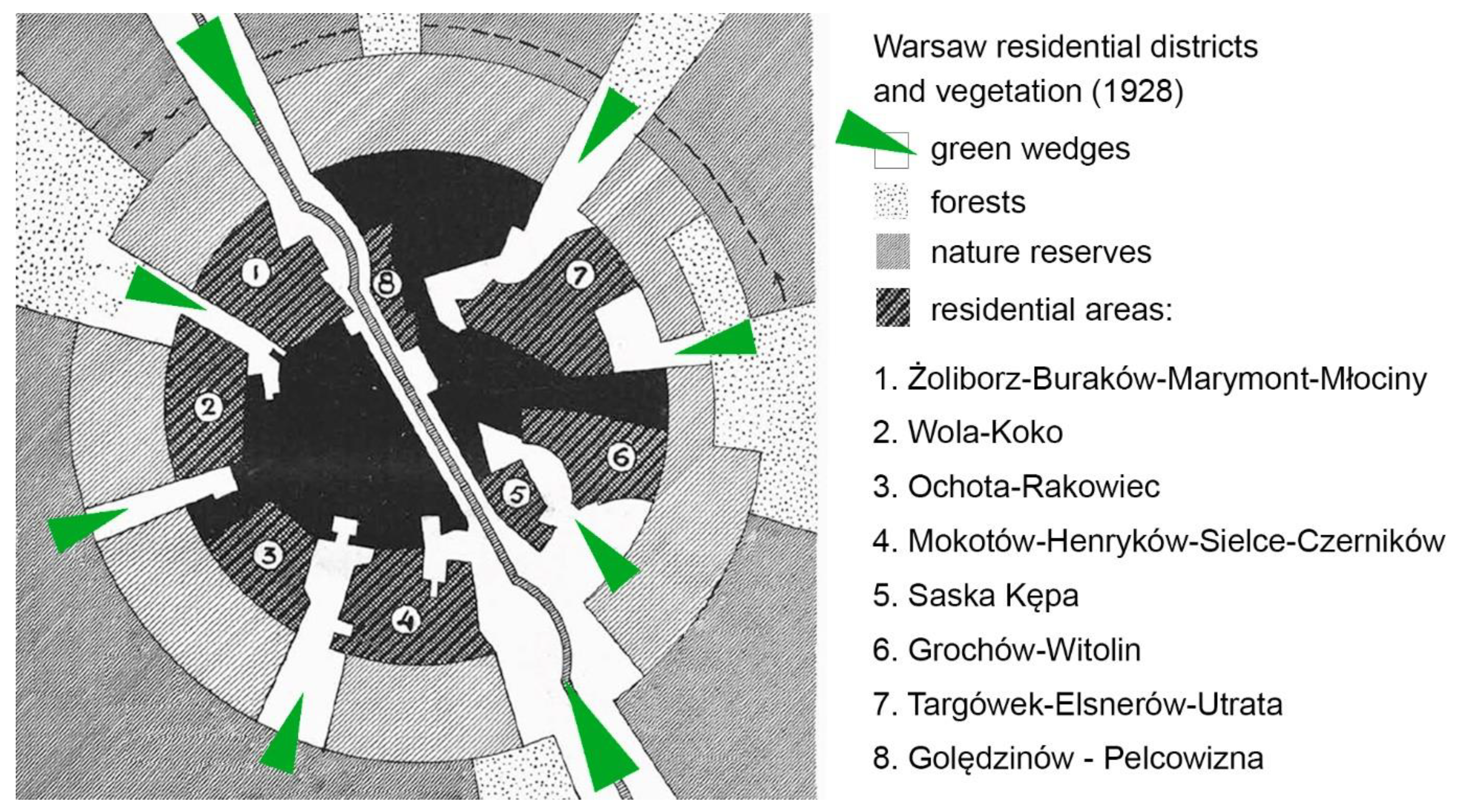
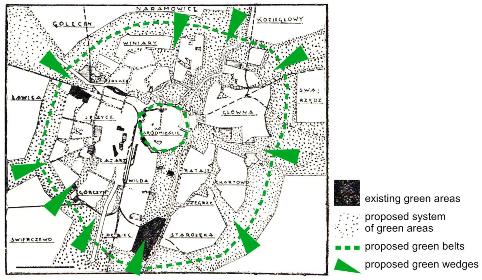
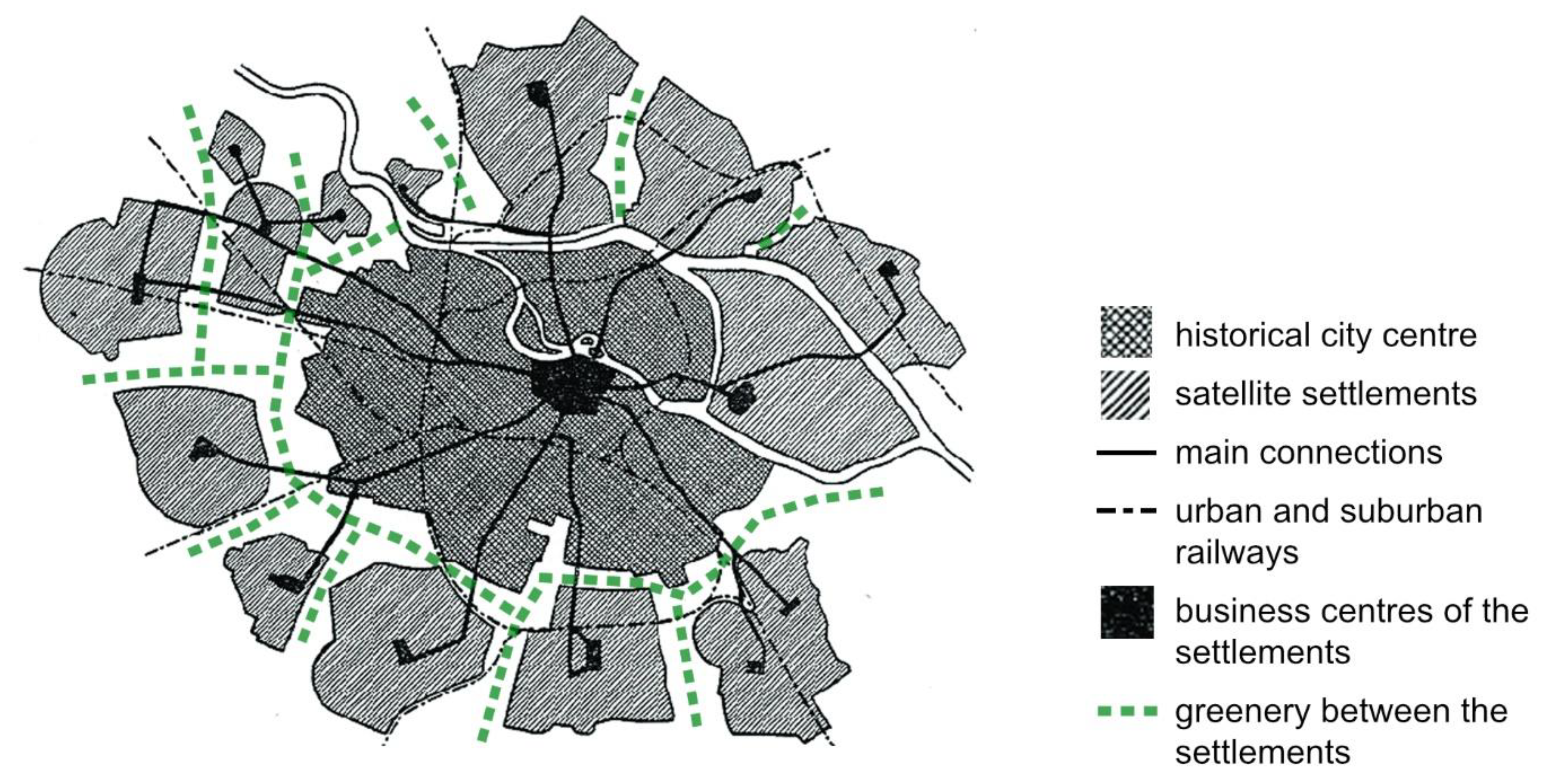
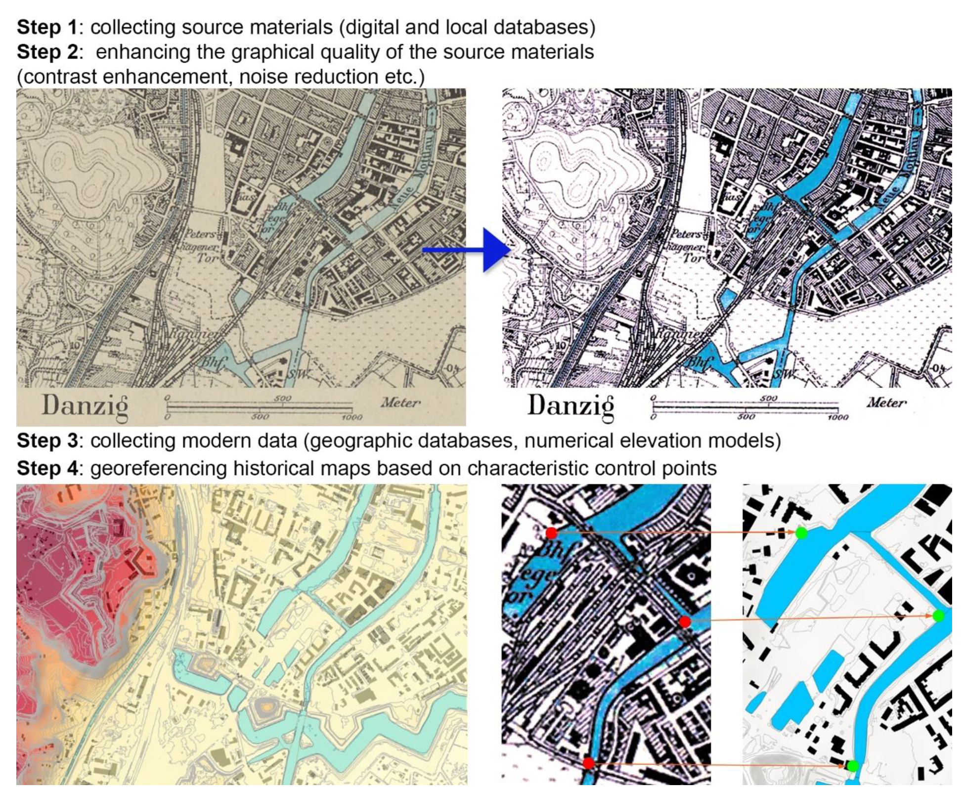
2.2. Analysis of the Historical Context

In the first stage of the research, all available source materials were identified and juxtaposed with the current spatial layouts of the cities. The workflow for the analysis and classification of the source materials is presented in Figure 7. After graphical amendments, the historical plans were georeferenced according to the current spatial datasets. It is important to note that due to the low degree of accuracy of the available historical plans, some state-of-the-art methods [70,71,72] were not available and the historical plans were adjusted manually, using the characteristic control points of the water system. However, when dealing with historical geographical materials, high accuracy is not always achievable [73].

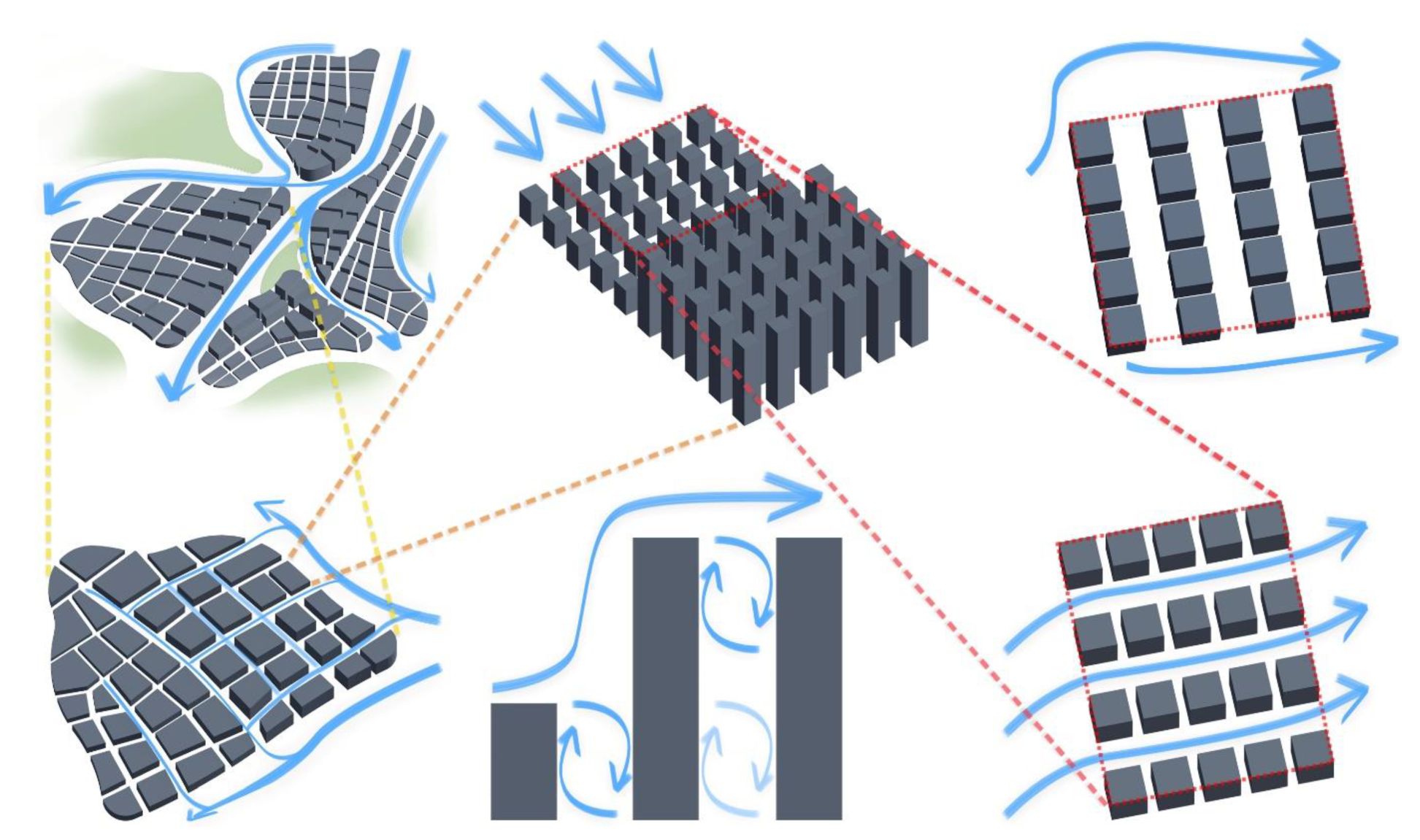
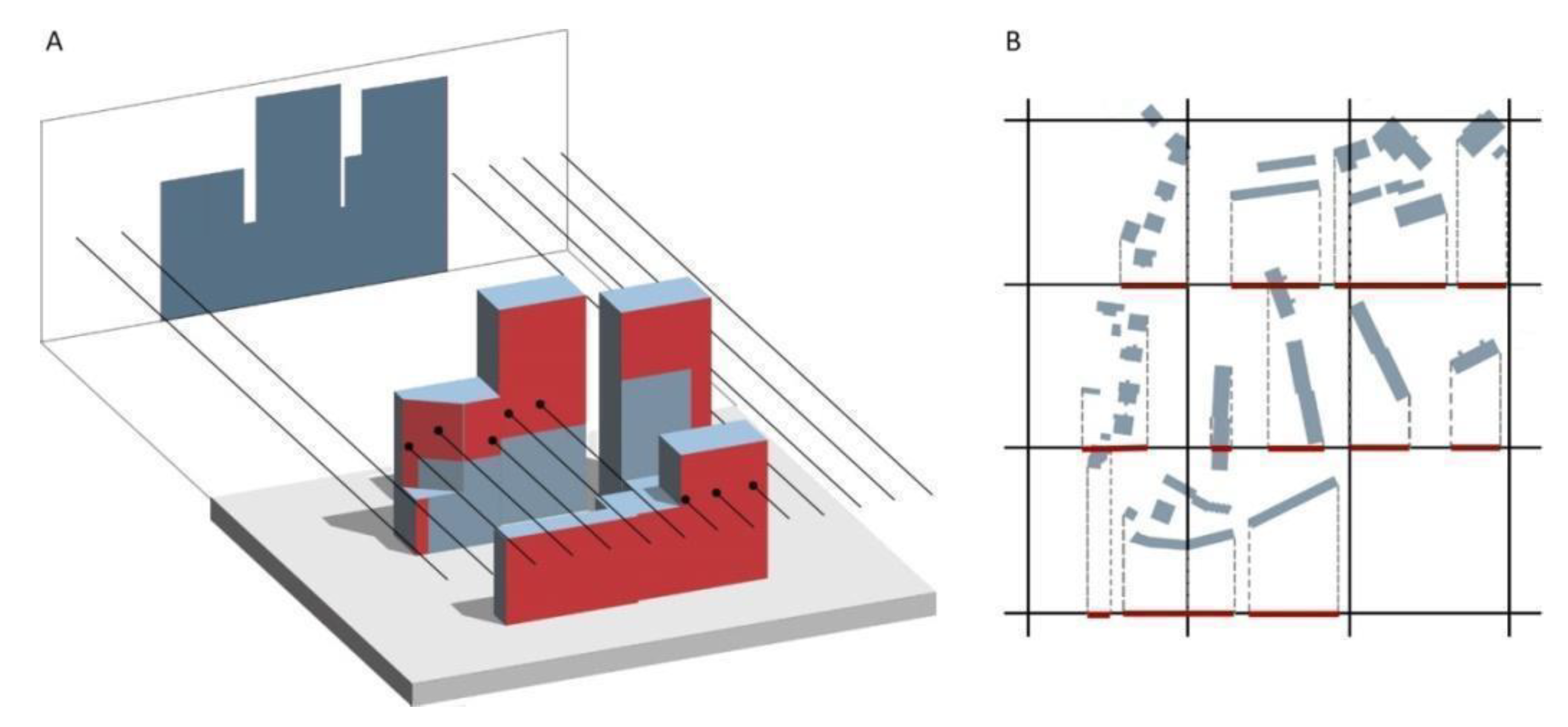
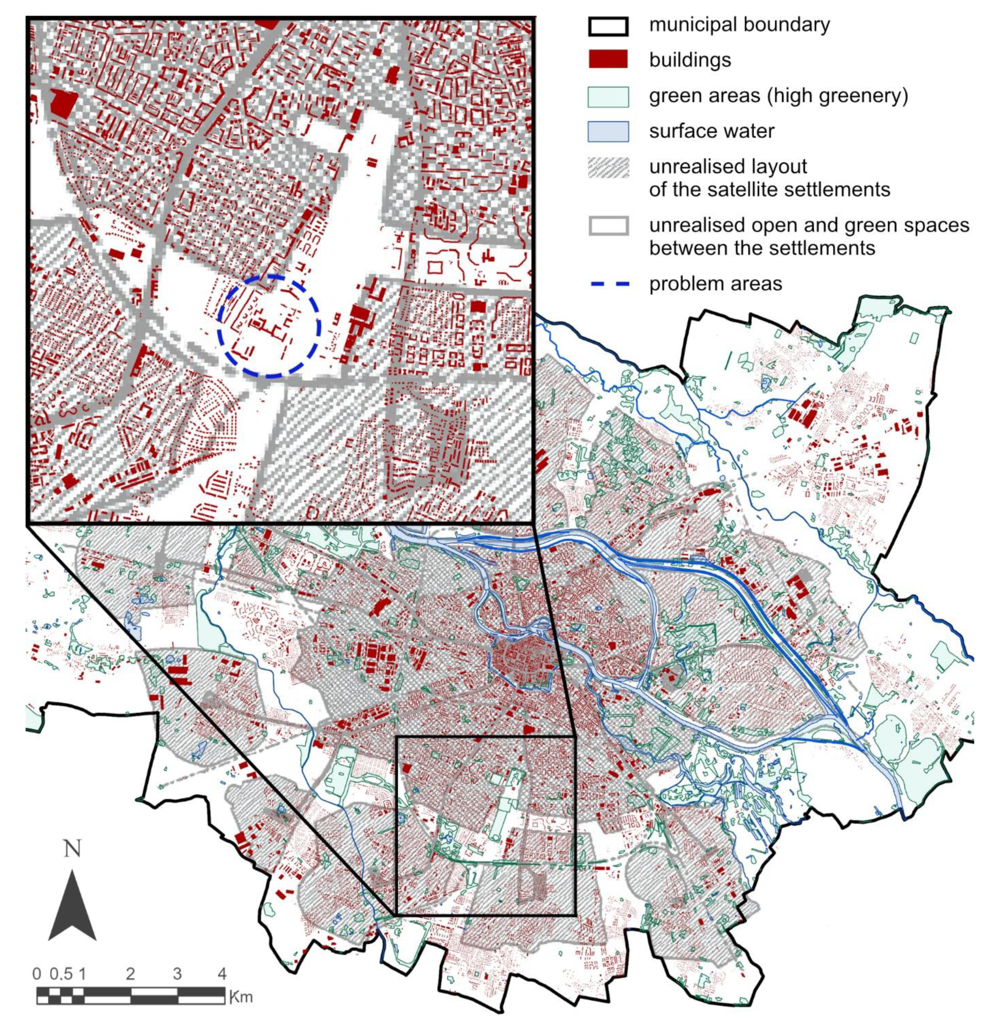
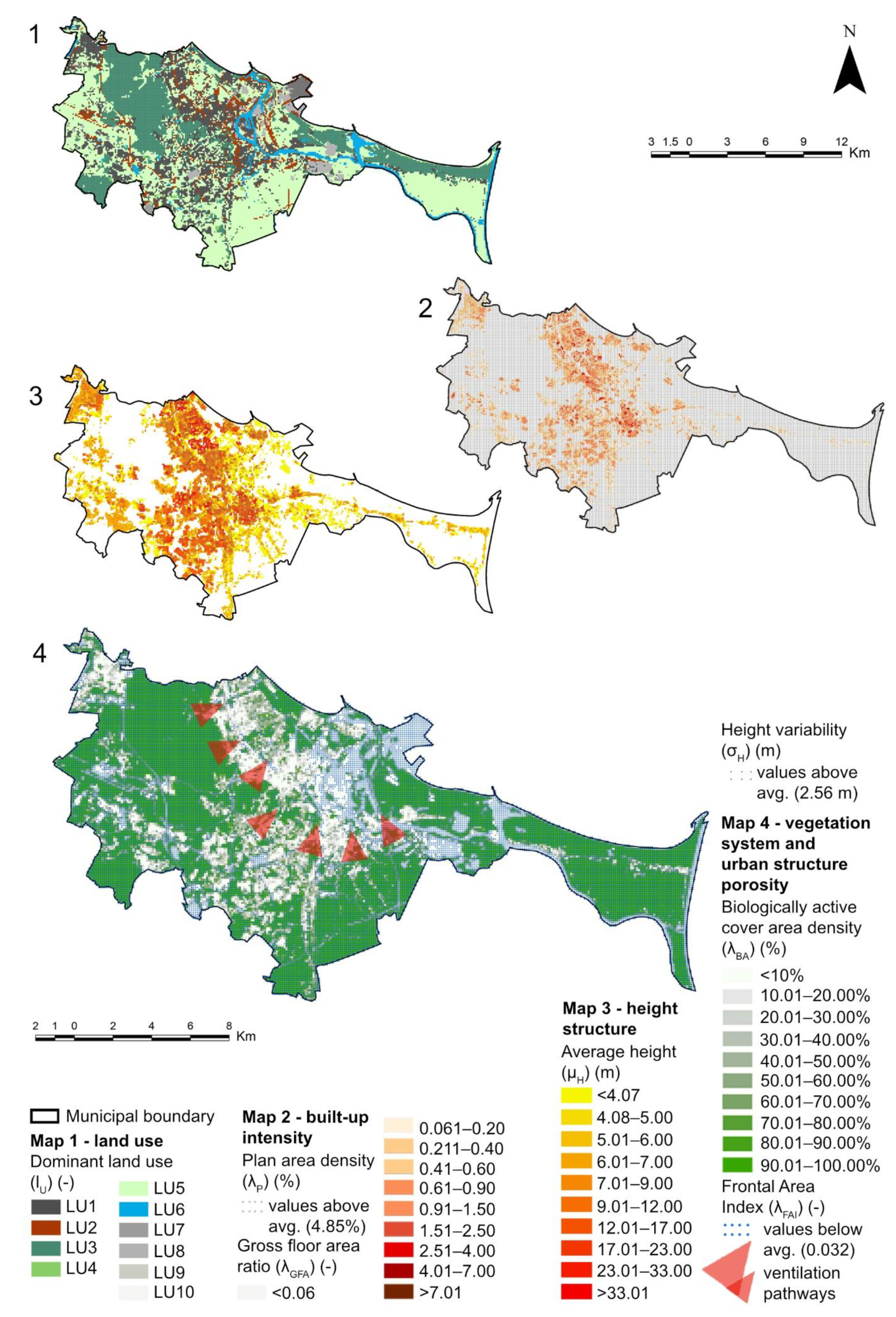
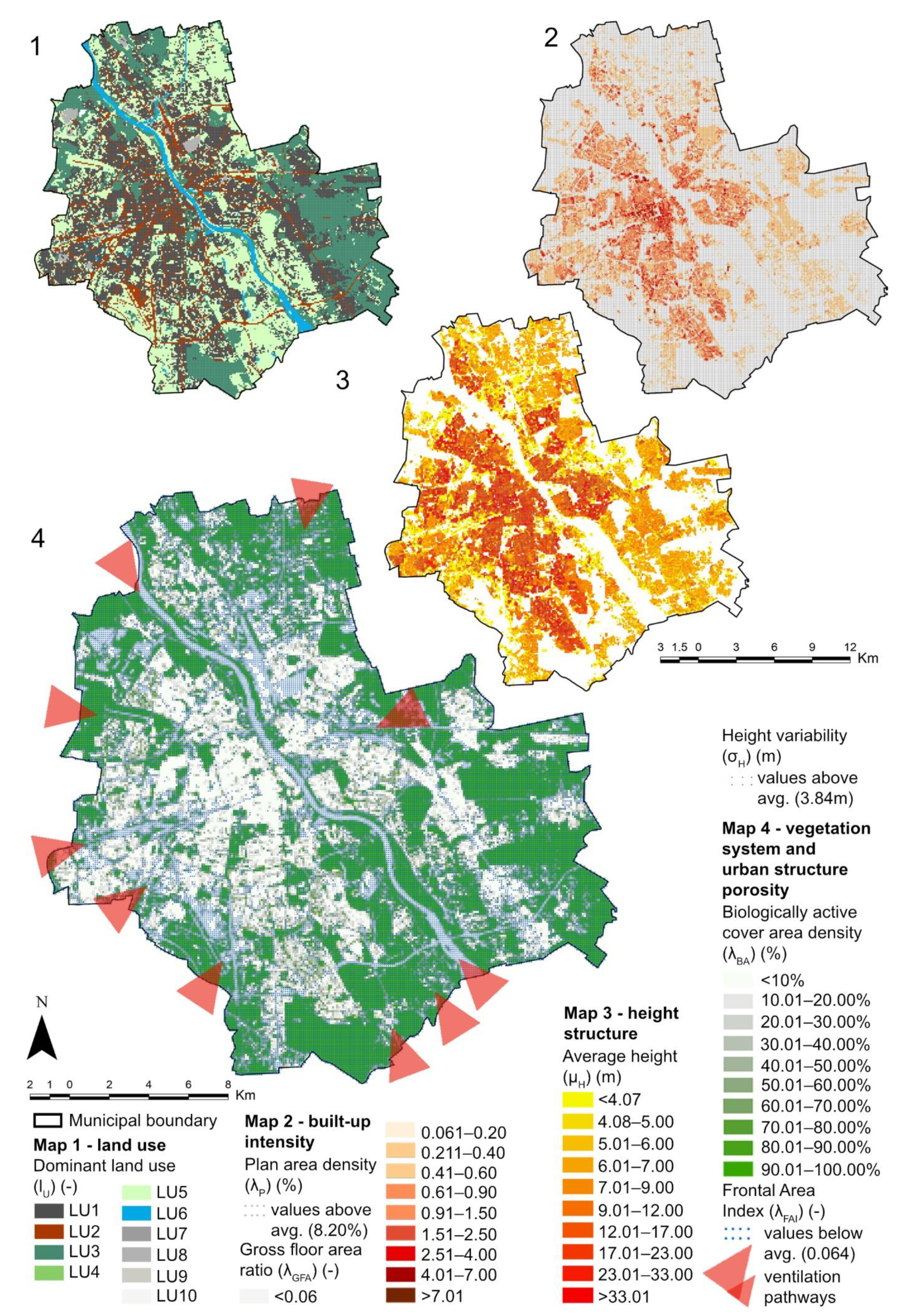
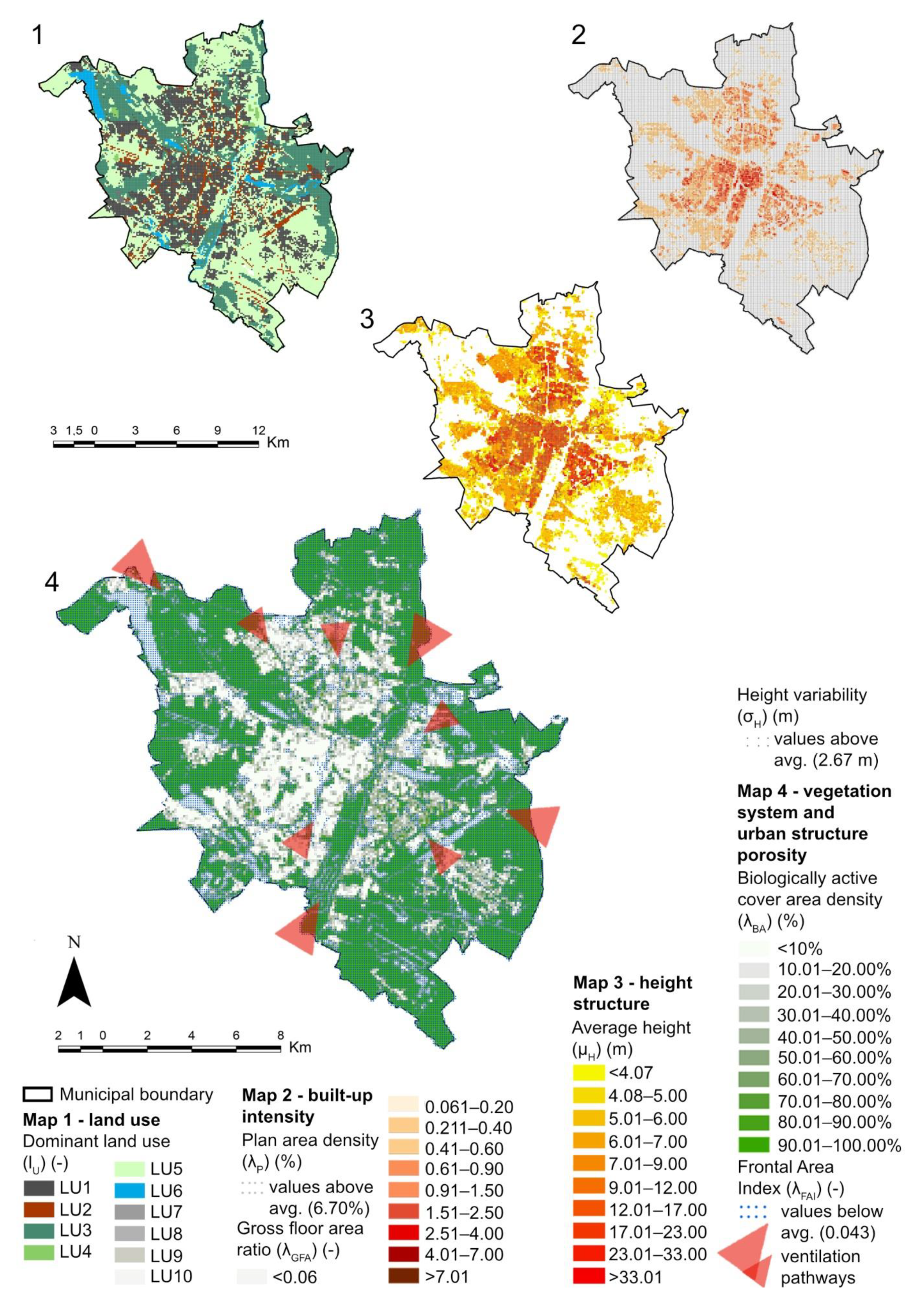
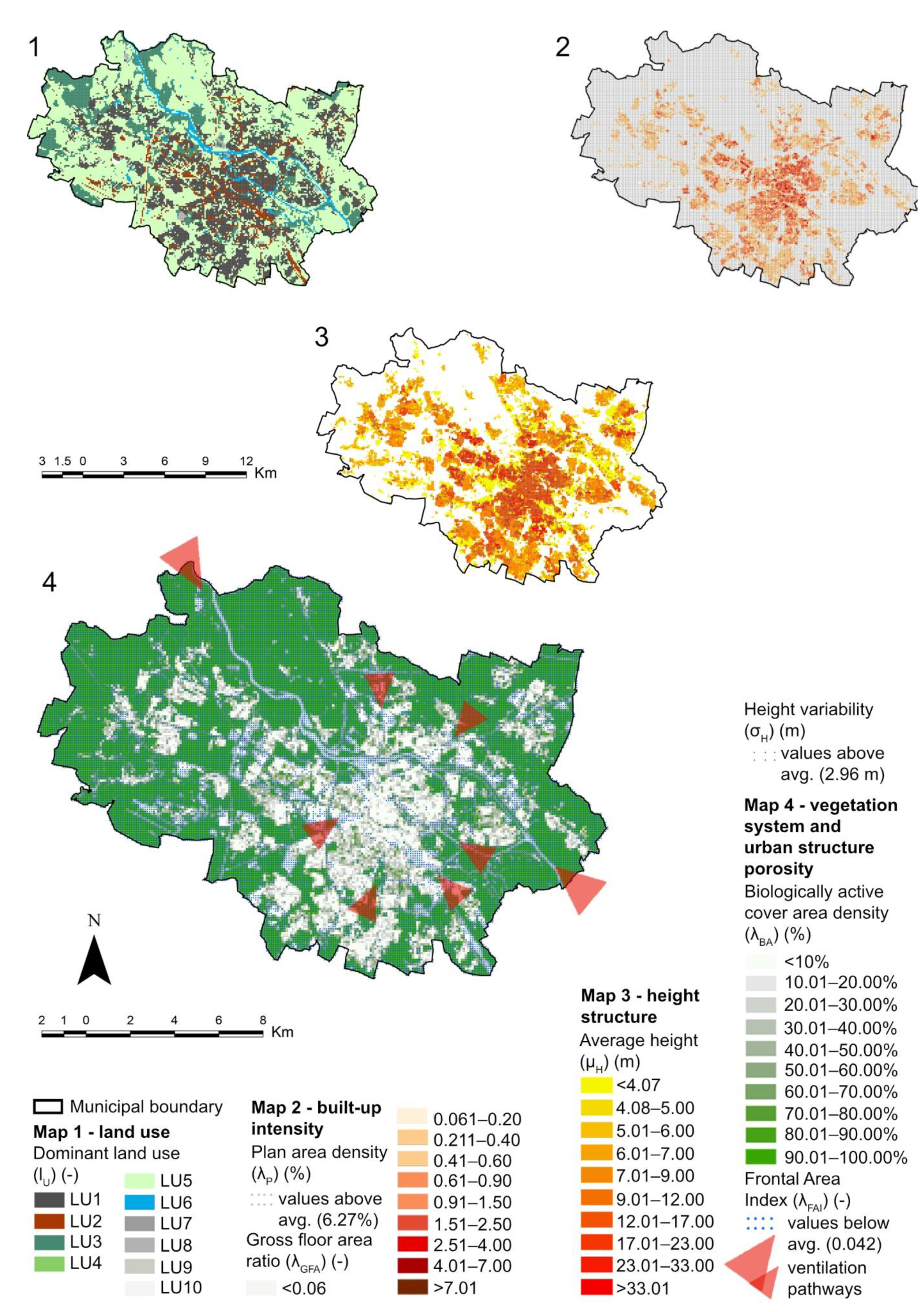
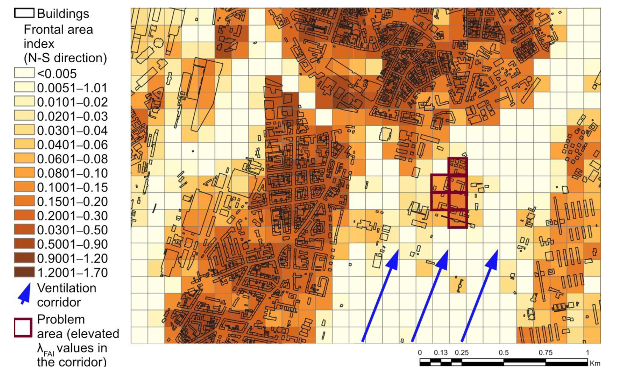
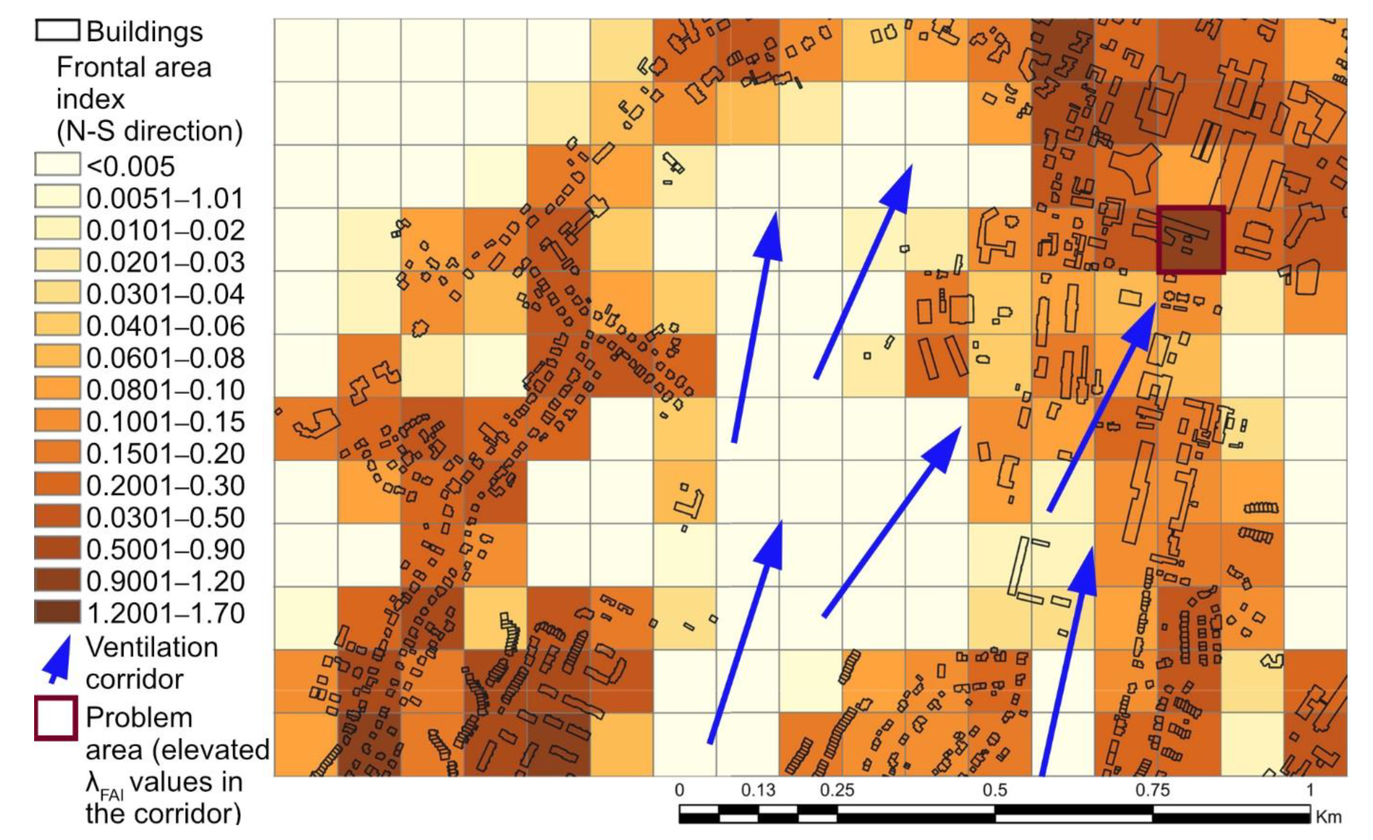
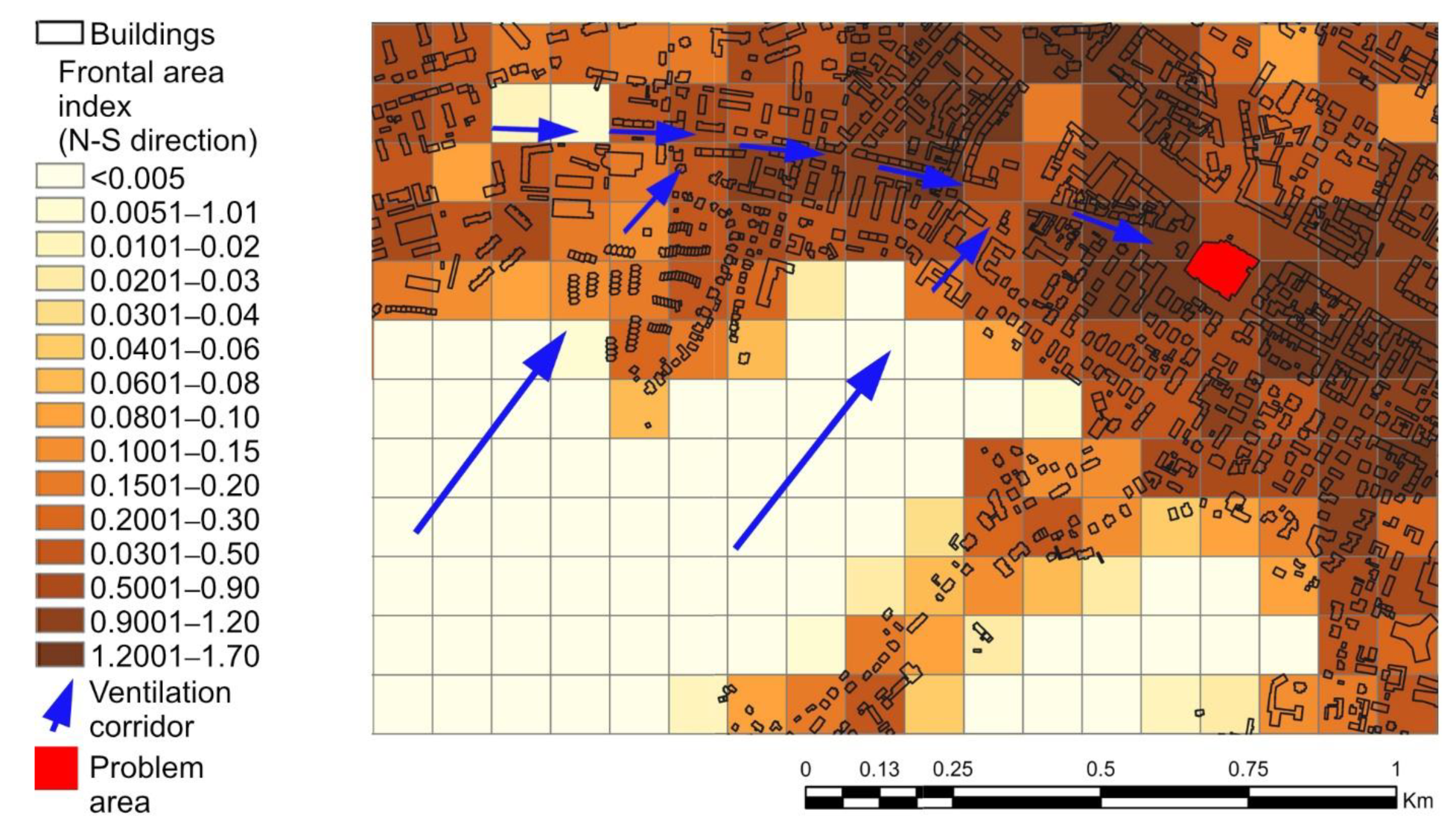
2.3. GIS Analysis—Identification of the Current Elements of the Ventilation Systems

In the second phase of the research, the urban forms of the four cities were quantified using GIS-based tools to identify the main elements of the current ventilation systems. Although the relationship between the parameters of urban form and urban ventilation or air quality is extremely complex and it is not always possible to definitively determine it [74], some urban form indicators, particularly those related to the effectiveness of the ventilation process, have been identified in previous research [8,9]. The following urban form indicators were selected, based on the previous research on the impact of urban structure on air quality and ventilation conditions—see Table 1.
All indicators were calculated with the ArcGIS Pro 2.9 software (Esri Inc., Redlands, CA, USA). For calculating each indicator, geoprocessing models were designed and automated using the ArcGIS 2.9 Model Builder©. The data was drawn from a database of topographical objects corresponding to a 1:10,000 topographic map, provided by the Head Office of Geodesy and Cartography [61]. It is a vector database containing the spatial location of the topographical objects, together with their characteristics, developed in the plane coordinates of the PL-1992 system (EPSG code: 2180). The data were retrieved in May 2022. A grid approach was adopted for the GIS calculations—see Figure 8. They were based on a 100 × 100-metre rectangular grid, which is often used in studies on the city scale regarding urban ventilation conditions, e.g., [12,15].
The following indicators—plan area density (λP), gross floor area ratio (λGFA), height variability (σH) and average height (μH)—were calculated using the methods described by Badach et al. (2020) [8]. For the frontal area index (λFAI), which is the indicator describing the relationship between urban structure and wind conditions, a set of methods was developed based on tools used in previous studies, adapting them to the available data describing the built-up structures. The concept of the frontal area index was developed by Grimmond and Oke (1999) [84] and Burian et al. (2002) [85] for the purposes of local climate zone and urban ventilation studies; it is defined as the sum of the frontal façades (façades facing the selected wind direction), divided by the site area. This definition was re-defined and modified for various studies, depending on the urban context and the focus of the analysis.
When calculating the frontal area index, two approaches are most commonly employed. In the first one, described, e.g., in [15,86], a set of lines, aligned with the selected wind direction and with a predefined spacing, is generated. Then the set of lines is intersected with the building layer. The lines intersecting with the buildings are counted and are then multiplied by the area resulting from the predefined line spacing and the building heights. If the effect of the imposing façades is to be eliminated, the given line is taken into account only once; it is counted only when it comes into contact with a building for the first time for a given site or grid cell—see Figure 9A. In another approach, described, e.g., in [60], the lines of the building’s external walls are created by projecting the width of the façade facing the selected wind direction to the grid cell boundary or plane, perpendicular to the wind direction. Each building height is assigned to the line representing its projected width. Then, the line widths are multiplied by the height parameter and summed up—see Figure 9B. By using this approach, the effect of imposing façades can be eliminated as well. Moreover, the frontal area index indicator can be calculated using three-dimensional GIS building data, e.g., using a dedicated application based on the ArcGIS Pro software called the Urban Morphology Extractor (UME) [82,87].
An approach based on the one proposed by Burghardt (2014) [88] for the ArcMap software (Esri Inc., Redlands, CA, USA) was adapted for the ArcGIS Pro software. Instead of creating Thiessen polygons for site partition, a grid approach was used, similarly to the approach of Wong et al. (2010) [15]. The same 100 × 100 metre grid was used, as with the previous indicators. In the first step, layers with lines representing the cardinal and inter-cardinal wind directions were generated, with 2 metres spacing. Then, buildings with the same heights and with a common edge were merged. Next, the wind lines were intersected with the buildings, resulting in information about the buildings’ heights being assigned to the wind lines. For each line intersecting the buildings, a new attribute was created, which was calculated by multiplying the building height by the line spacing (2 metres). Finally, this attribute was summed up for each grid cell, based on the unique cell ID, and divided by the grid cell area. For some high-density urban areas, a correction is often required to account for the effect of imposing buildings (see, e.g., [15,89]). However, given the relatively low built-up density of the selected cities, the lack of such a correction did not lead to the overestimation of this indicator, so it was not taken into account.

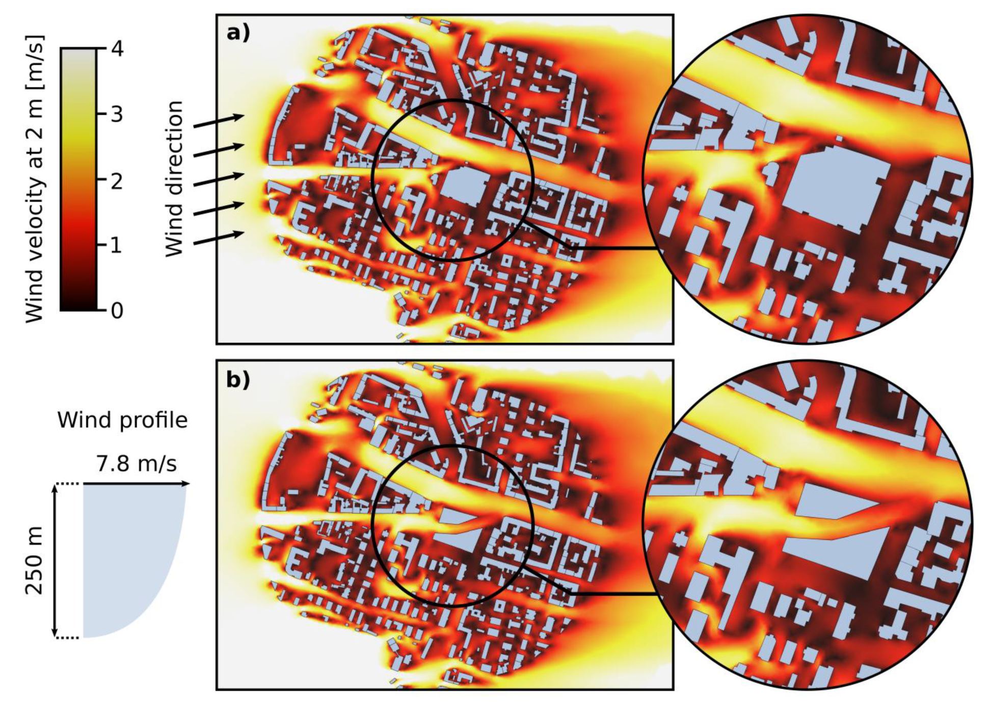
2.4. Local Case Studies—Design Recommendation

Analysis of the λFAI spatial distribution and its values in particular areas and even grid cells was used to designate some local problem areas—examples of urban development scenarios that interrupted the continuity of the ventilation systems. Subsequently, CFD simulations were used to illustrate the finding that city-scale GIS-based analysis is not sufficiently sensitive to identify improper design solutions that inhibit the city’s ventilation efficiency due to micro-scale wind environment effects. A CFD case study of a particular problem area was performed to demonstrate that the integration of various analytical and simulation tools is required for effective urban ventilation management.
The ventilation simulations were conducted using the Autodesk CFD 2021 software (Autodesk, San Rafael, CA, USA). An area with a radius of 400 m around a particular point of interest was modelled in CAD/CAM software Autodesk AutoCAD 2021 (Autodesk, San Rafael, CA, USA), based on data from the geographic database, and was then imported into the CFD software. The simulation parameters and domain were set according to the Architectural Institute of Japan’s guidelines for CFD predictions of the urban wind environment [90]. As discussed extensively in many previous studies, the CFD technique is currently the most accurate tool for such an analysis on a local scale [91]. However, high simulation accuracy was not pursued in this case. The simulations were performed to illustrate how this technique, already well-established or even required in the planning and design process in various cities (see, e.g., [92,93]), could be a basis for design solutions that are more beneficial for the local wind environment.

3. Results

An introductory evaluation of the degree of preservation of the ventilation corridors was performed by superimposing the georeferenced historical maps and contemporary urban maps. Since maps contain only two-dimensionalinformation, the analysis of such a superimposition only makes it possible to gain an approximate insight into the researched problem. However, it indicates that the ventilation corridors are often blocked by later built-up structures. Figure 10 presents fragments of Gdańsk’s large-scale Zaspa and Przymorze housing developments, built in the 1970s, clearly showing that the originally designed ventilation system was, generally, not taken into consideration in urban development plans of that time. A striking example of such negligence are the elongated and wavy, 11-story buildings that were placed across the ventilation corridor. Similarly, the hexagonal forms of blocks in the Zaspa estate were built at the intersection of the two main ventilation corridors, heavily impairing the airflow. In other cases, the buildings are located along the direction of ventilation, causing less damage to the functioning of the whole system.
Similarly, in Warsaw, several examples of improper design solutions can be found, many of which were erected in recent years when an awareness of the issues of city breathability and air quality management was more widespread. The massive bulk of the recently built Galeria Bemowo shopping centre was constructed across one of the ventilation wedges—see Figure 11. In this case, a more fragmented building complex, oriented along the direction of ventilation, would have been more beneficial.
In Poznań, in recent years, a new multi-storey residential and commercial development was permitted in the area of the Droga Dębińska, with the Bielniki and Piastowska streets within the southern wedge—see Figure 12.
Finally, in Wrocław, the spatial layout of the complex of the Military Clinic Hospital, with its elongated façade facing the direction of the ventilation corridor, was not properly shaped—see Figure 13.
Contemporary GIS tools provide more in-depth insights into the continuity of ventilation systems by enabling the integration of two-dimensional data and land-use characteristics. Figure 14, Figure 15, Figure 16 and Figure 17 show the distribution of the urban form indicators related to the process of urban ventilation. They also reveal the differences in the urban morphology of the investigated cities. The average values of specific indicators (λP, σH, λFAI) for each city, provided in the legends for Figure 14, Figure 15, Figure 16 and Figure 17, confirm their spatial heterogeneity. In particular, the spatial distribution of λFAI was considered in relation to the urban ventilation systems. By mapping the λFAI values below the average value in each city (the areas marked with blue dots in map 4, in Figure 14, Figure 15, Figure 16 and Figure 17) and λBA (green color), the major ventilation pathways and some secondary paths were identified.
A close-up analysis of the λFAI values shows how city-scale mapping can rapidly identify local problem areas—see Figure 18 and Figure 19. The first case shows the previously discussed residential and commercial development in Poznań. In the second case, the λFAI mapping pointed to one of the Gdańsk University of Technology campus buildings, which was constructed post-WWII and was built perpendicularly to the direction of a local ventilation pathway, alongside one of the waterways (currently underground).
However, in some cases, this data needs to be analysed in relation to the existing urban layout, which can be illustrated using the example of the Manhattan shopping centre in Gdańsk (indicated in red in Figure 20). It can be noticed that even though the highest λFAI values indicate other problem areas, the more serious problem related to the inhibited ventilation efficiency is the large bulk of this building. This is because it is blocking a secondary ventilation pathway along Partyzantów street, which is connected to the main ventilation corridors in this area.
Although using GIS-based tools makes it possible to identify the existing elements of ventilation systems and ventilation pathways, the results of CFD modelling more accurately recognises the characteristics of air movement disturbances, especially in the urban micro-scale. The CFD simulations conducted for the Manhattan shopping centre case study—see Figure 21—confirm that the GIS-based analysis was not sufficient to identify this issue. Analysis of the results of the CFD modelling provides more in-depth insights into how particular building arrangements constructed in the paths of ventilation corridors negatively affect air movement and ventilation efficiency. The continuity of the ventilation pathway in this area could be maintained, e.g., by dividing the complex into two parts, with a shopping street between them, as an extension of Partyzantów street—see Figure 21.

4. Discussion and Recommendations

A comparative analysis of urban ventilation conditions in four Polish cities demonstrates, in general, the significant potential of early twentieth-century planning concepts. They were designed without the use of advanced analytical tools, but they took into account local knowledge of the main wind directions, local topography, the location of watercourses, the natural disposition of green areas, and the characteristics of the urban structure. The main assumptions of these early urban ventilation systems are still visible in all the analysed cities. However, GIS-based analysis made it possible to correct some compromised airflow directions to the prevailing ones through an examination of the current city structure and the land-use characteristics. Additionally, the presented method led to the identification of problem areas with major disruptions to airflow. While analysis using GIS-based tools confirms the disturbances on the scale of the whole city, CFD modelling offers detailed insights into the process causing impaired airflow due to the improper location of specific buildings.
With an increasing awareness of the value of the quality of life in healthy cities and the ongoing pursuit toward sustainable development goals, after decades of negligence, the value of effective urban ventilation is re-appearing. This is, however, happening at a different pace in each of the four analysed cities. In the case of the city of Gdańsk, the issue of urban ventilation is not even mentioned in strategic planning documents. This extreme situation could be due to the massive exchange of population after 1945, which brought about a radical break in the continuity of urban design concepts. In the strategic general planning documents for Gdańsk, there are no provisions protecting the ventilation corridors. Even so, the issue of air quality and urban ventilation corridors is slowly beginning to appear in the individual local development plans. In 2021, the Gdańsk Development Office commenced a study regarding the definition of the Gdańsk Green Policy [94], where city ventilation corridors will be designated and then gradually introduced to local planning acts. To protect the local ventilation pathways, regulations concerning building height, density and the percentage of biologically active areas will be appropriately adjusted in the local spatial development plans. As this study indicates, such provisions are still incomplete, and other urban form indicators should be also taken into consideration. For example, the results of the CFD study prove that low buildings do not guarantee undisturbed airflow—their layout and fragmentation in relation to the local wind conditions are also crucial.
After decades of inattention, the wedged-shaped system of ventilation corridors in Warsaw that complement the main ventilation corridor of the Vistula River started to be discussed again and was recommended for protection in 1992, when the issue of air exchange and regeneration appeared in the “General Spatial Development Plan for the Capital City of Warsaw” [95]. This document named nine ventilation corridors running radially from the city outskirts toward its centre. These are consistent with the findings of this study, as well as those of previous studies [96,97]. This identification, however, did not halt the process of intensive housing development and construction that largely reduced the functionality of important ventilation corridors, the large-scale development in Bemowo being a striking example. In 2006, the document “Eco-physiographic Study” was issued [98], including ventilation recommendations to inform planning decisions and guide the directions of the spatial development of Warsaw. Despite these recommendations, in numerous cases, urban pressure and the gaps in the local planning regulations have led to further disturbances in the functionality of the ventilation system, as revealed by this study.
In the city of Poznań, the latest planning documents, which are very clearly defined and act as a continuation of the early modern concepts, define the strategy for better ventilation of the city. The protection of the system of green rings and wedges is included in the Study on Conditions and Spatial Development Directions for Poznań [99]. The provisions of the new study not only protect the green wedges as ventilation corridors but also call for new green belts, especially along the communication routes. The strategy regarding blue-green networks explicitly refers to the Stübben Ring and the belt along the outer ring of fortifications. However, the integrity of this system is still not properly protected in the planning and development practice of the area [100].
In the Study of Conditions and Directions of Spatial Development of Wrocław [101], the question of urban ventilation is also discussed; however, there is no reference to the earlier concepts—most probably, due to the very vague politics of urban ventilation and the reduced degree of its implementation in the first decades of the twentieth century. To protect the natural environment against air, water and soil pollution, the study defines sectoral policies, including air quality policy, among other factors. According to the study, to reduce air pollution, the green wedges that cut into the city structure should be re-established and protected. This is also consistent with the findings of our study, in which we identified a centric layout of the ventilation system. However, in other studies, different concepts were also considered (see, e.g., [102]). Additionally, the connections between existing green areas will be shaped to transform the scattered green spaces into networks.
All these provisions in the recent planning documents confirm that the issue of urban ventilation has become an essential element of urban policy. Advanced tools and methods are needed to support the intentions expressed in these general planning acts and facilitate their transfer into operational decisions, along with their integration into more detailed local spatial development plans. For example, as research has shown, there are large differences in λFAI depending on the orientation of the buildings. This means that in most airflow-sensitive urban areas, restrictions should not only concern building heights but also their orientations and the distances between them, which may vary depending on the prevailing wind conditions. Similarly, it may happen that the building heights and intensities are low but they still block the airflow, which confirms the importance of CFD research on the urban micro-scale.
For the purpose of sustaining or improving the ventilation efficiency in cities, the designation of new networks of open public spaces [103], blue-green connections [104,105] and the introduction of high-density urban structures [28,92] should be subjected to careful consideration of the research results and recommendations. Some design aspects are particularly relevant in this process—for example, the re-development of waterfront areas. This is because ventilation corridors along the riverbeds are very often a core part of urban ventilation systems, as it is in the case of the studied cities. Therefore, the waterfront areas, in particular, should be considered in future studies of urban ventilation systems [92,106].
The design and maintenance of the urban green infrastructure represent another crucial aspect that should be integrated into urban air quality and ventilation management. Future research and planning practice based on the proposed workflow can be broadened by using more indicators to comprehensively describe the parameters of the vegetation systems. In this study, the vegetation systems in the four cities were studied in relation to their historical development; then, λBA was calculated to account for the current spatial distribution of the green areas. The structure of urban vegetation, both at the city- and micro-scale, is relevant to urban air quality and ventilation management [8,107], but its proper design to improve ventilation conditions is not straightforward [108]. Therefore, more scale-sensitive parameters describing the vegetation parameters should be included in further research, e.g., crown and plant height or vegetation density and porosity [109], while accounting for the variations in the vegetation forms [110].
Finally, it is of particular importance that the scientific knowledge regarding effective urban ventilation becomes widespread among practitioners, policymakers and authorities. However, as previously investigated by Badach et al. [11], this is not always the case in the Polish context. Therefore, the awareness of the local stakeholders should be subjected to further investigation. More attention should be given to the dissemination of the results of current research results on improving city breathability using planning and design solutions.

5. Conclusions

It is becoming evident that effective urban ventilation studies are of key importance in the drive to improve urban air quality. At the same time, in many Polish cities, including the four that have been analysed in this study, intensive urban transformation processes have been taking place—in the majority of cases, without any ventilation monitoring tools. The high pace of urban spatial development results in changes in the land use characteristics of suburban areas that may affect the efficiency of ventilation corridors. The rise in building heights and their frontal index in city centres, when uncontrolled, may lead to serious disturbances in airflow.
The methods proposed in this paper based on GIS tools, including the analysis of historical source materials, supported by CFD modelling make it possible to monitor the changes in urban structure and to verify the ventilation paths. The system enables the monitoring and shaping of airflow systems and evaluation of urban ventilation efficiency. Moreover, it is worth pointing out that the set of urban form indicators proposed in this study, including the indicators describing the buildings’ density and height structure, are commonly used in urban planning, for example, to determine the parameters for new developments in local spatial plans. We demonstrated that the same parameters are useful for urban air quality management, which further facilitates the integration of urban ventilation control within the process of urban planning.
However, other parameters used in this study, for example, λFAI, are rarely incorporated into local and city-scale planning guidelines and directives in Poland. It is our recommendation that this parameter should be more commonly used as a tool to control the parameters of new developments, especially in the more densely built-up urban areas and in those areas that are part of ventilation systems. The proposed GIS-based workflow may be used as a supporting planning and design tool, especially on the city scale. The urban form indicators can be calculated and updated on an ongoing basis, to examine whether the designed layout impedes effective ventilation. As such, this method also allows for updating the current ventilation systems to account for the ongoing spatial development of the city and designing new ventilation corridors. Based on the analysis of these indicators, it is possible to identify problem areas and study them in detail.
Moreover, we wanted to show that the use of GIS tools can account for the geometrical features of the urban form but it does not account for local phenomena related to the ventilation process. Calculating the urban form indicators and, in particular, λFAI, is useful for the effective evaluation of the ventilation systems at the city scale, but more suitable numerical simulations, supported by an analysis of the local conditions, should be used to support urban design on a local scale (the scale of building complexes or even single buildings). It would be beneficial if the use of this tool was required by local planning regulations, at least in the most problematic areas. As discussed above, there are already some examples of such requirements in other countries.
It is not possible to define one overall strategy for better air quality in all of the four cities, due to their different geographical and urban conditions, as well as the introduction of different urban ventilation concepts in the first decades of the twentieth century. The tools presented in this paper, based on the use of GIS-based analysis and CFD modelling, make it possible to identify the existing elements of urban ventilation systems, designate problem areas, and simulate changes in ventilation efficiency and scenarios as an effect of new urban transformations. To formulate detailed recommendations for any specific city, more detailed on-site local studies are needed, supported by the tools and procedures proposed in this paper.

Author Contributions

Conceptualization, J.B., J.S., W.B., J.G. and L.N.; methodology, J.B.; investigation, J.B.; writing—original draft preparation, J.B., J.S., W.B., J.G. and L.N.; writing—review and editing, J.B., J.S., W.B., J.G. and L.N.; visualization, J.B. All authors have read and agreed to the published version of the manuscript.

Funding

This research was financially supported by the National Science Centre in Poland (Grant no. 2019/33/N/HS4/00978).

Institutional Review Board Statement

Not applicable.

Informed Consent Statement

Not applicable.

Data Availability Statement

The relevant data underlying this study are fully available under the details provided in the references. For further questions, please contact the corresponding author.

Acknowledgments

The authors would like to thank Wojciech Wojnowski for his help with the CFD simulations.

Conflicts of Interest

The authors declare no conflict of interest.

References

  1. World Health Organization. Air Pollution. Available online: https://www.who.int/health-topics/air-pollution#tab=tab_1 (accessed on 30 June 2022).
  2. Tan, X.; Han, L.; Zhang, X.; Zhou, W.; Li, W.; Qian, Y. A review of current air quality indexes and improvements under the multi-contaminant air pollution exposure. J. Environ. Manag. 2021, 279, 111681. [Google Scholar] [CrossRef]
  3. European Environment Agency. Exceedance of Air Quality Standards in Europe. Available online: https://www.eea.europa.eu/ims/exceedance-of-air-quality-standards (accessed on 20 November 2021).
  4. Court of Justice of the European Union. Judgement in Case C-336/16; Court of Justice of the European Union: Luxembourg, 2018. [Google Scholar]
  5. Mirzaei, P.A.; Haghighat, F. A procedure to quantify the impact of mitigation techniques on the urban ventilation. Build. Environ. 2012, 47, 410–420. [Google Scholar] [CrossRef]
  6. Ren, C.; Yang, R.; Cheng, C.; Xing, P.; Fang, X.; Zhang, S.; Wang, H.; Shi, Y.; Zhang, X.; Kwok, Y.T.; et al. Creating breathing cities by adopting urban ventilation assessment and wind corridor plan—The implementation in Chinese cities. J. Wind Eng. Ind. Aerodyn. 2018, 182, 170–188. [Google Scholar] [CrossRef]
  7. Yang, J.; Shi, B.; Shi, Y.; Marvin, S.; Zheng, Y.; Xia, G. Air pollution dispersal in high density urban areas: Research on the triadic relation of wind, air pollution, and urban form. Sustain. Cities Soc. 2020, 54, 101941. [Google Scholar] [CrossRef]
  8. Badach, J.; Voordeckers, D.; Nyka, L.; Van Acker, M. A framework for Air Quality Management Zones-useful GIS-based tool for urban planning: Case studies in Antwerp and Gdańsk. Build. Environ. 2020, 174, 106743. [Google Scholar] [CrossRef]
  9. He, B.-J.; Ding, L.; Prasad, D. Enhancing urban ventilation performance through the development of precinct ventilation zones: A case study based on the Greater Sydney, Australia. Sustain. Cities Soc. 2019, 47, 101472. [Google Scholar] [CrossRef]
  10. Kurppa, M.; Hellsten, A.; Auvinen, M.; Raasch, S.; Vesala, T.; Järvi, L. Ventilation and Air Quality in City Blocks Using Large-Eddy Simulation—Urban Planning Perspective. Atmosphere 2018, 9, 65. [Google Scholar] [CrossRef] [Green Version]
  11. Badach, J.; Dymnicka, M.; Załęcki, J.; Brosz, M.; Voordeckers, D.; Van Acker, M. Exploring the Institutional and Bottom-Up Actions for Urban Air Quality Improvement: Case Studies in Antwerp and Gdańsk. Sustainability 2021, 13, 11790. [Google Scholar] [CrossRef]
  12. Guo, F.; Zhang, H.; Fan, Y.; Zhu, P.; Wang, S.; Lu, X.; Jin, Y. Detection and evaluation of a ventilation path in a mountainous city for a sea breeze: The case of Dalian. Build. Environ. 2018, 145, 177–195. [Google Scholar] [CrossRef]
  13. Lou, B.; Barbieri, D.M.; Passavanti, M.; Hui, C.; Gupta, A.; Hoff, I.; Lessa, D.A.; Sikka, G.; Chang, K.; Fang, K.; et al. Air pollution perception in ten countries during the COVID-19 pandemic. Ambio 2021, 51, 531–545. [Google Scholar] [CrossRef]
  14. Wang, W.; Yang, T.; Li, Y.; Xu, Y.; Chang, M.; Wang, X. Identification of pedestrian-level ventilation corridors in downtown Beijing using large-eddy simulations. Build. Environ. 2020, 182, 107169. [Google Scholar] [CrossRef]
  15. Wong, M.S.; Nichol, J.E.; To, P.H.; Wang, J. A simple method for designation of urban ventilation corridors and its application to urban heat island analysis. Build. Environ. 2010, 45, 1880–1889. [Google Scholar] [CrossRef]
  16. Zheng, Z.; Ren, G.; Gao, H.; Yang, Y. Urban ventilation planning and its associated benefits based on numerical experiments: A case study in beijing, China. Build. Environ. 2022, 222, 109383. [Google Scholar] [CrossRef]
  17. Azizi, M.M.; Javanmardi, K. The Effects of Urban Block Forms on the Patterns of Wind and Natural Ventilation. Procedia Eng. 2017, 180, 541–549. [Google Scholar] [CrossRef]
  18. Zhang, Y.; Gu, Z. Air quality by urban design. Nat. Geosci. 2013, 6, 506. [Google Scholar] [CrossRef]
  19. Chen, L.; Hang, J.; Sandberg, M.; Claesson, L.; Di Sabatino, S.; Wigo, H. The impacts of building height variations and building packing densities on flow adjustment and city breathability in idealized urban models. Build. Environ. 2017, 118, 344–361. [Google Scholar] [CrossRef]
  20. Hang, J.; Li, Y.; Sandberg, M.; Buccolieri, R.; Di Sabatino, S. The influence of building height variability on pollutant dispersion and pedestrian ventilation in idealized high-rise urban areas. Build. Environ. 2012, 56, 346–360. [Google Scholar] [CrossRef]
  21. Lee, R.X.; Jusuf, S.K.; Wong, N.H. The study of height variation on outdoor ventilation for Singapore’s high-rise residential housing estates. Int. J. Low-Carbon Technol. 2015, 10, 15–33. [Google Scholar] [CrossRef]
  22. Liao, W.; Hong, T.; Heo, Y. The effect of spatial heterogeneity in urban morphology on surface urban heat islands. Energy Build. 2021, 244, 111027. [Google Scholar] [CrossRef]
  23. Maing, M. Superblock transformation in Seoul Megacity: Effects of block densification on urban ventilation patterns. Landsc. Urban Plan. 2022, 222, 104401. [Google Scholar] [CrossRef]
  24. Mei, S.J.; Hu, J.T.; Liu, D.; Zhao, F.Y.; Li, Y.; Wang, Y.; Wang, H.Q. Wind driven natural ventilation in the idealized building block arrays with multiple urban morphologies and unique package building density. Energy Build. 2017, 155, 324–338. [Google Scholar] [CrossRef]
  25. Ramponi, R.; Blocken, B.; de Coo, L.B.; Janssen, W.D. CFD simulation of outdoor ventilation of generic urban configurations with different urban densities and equal and unequal street widths. Build. Environ. 2015, 92, 152–166. [Google Scholar] [CrossRef] [Green Version]
  26. Trindade da Silva, F.; Reis, N.C.; Santos, J.M.; Goulart, E.V.; Engel de Alvarez, C. The impact of urban block typology on pollutant dispersion. J. Wind Eng. Ind. Aerodyn. 2021, 210, 104524. [Google Scholar] [CrossRef]
  27. Wen, H.; Malki-Epshtein, L. A parametric study of the effect of roof height and morphology on air pollution dispersion in street canyons. J. Wind Eng. Ind. Aerodyn. 2018, 175, 328–341. [Google Scholar] [CrossRef]
  28. Ng, E. (Ed.) Designing High-Density Cities For Social and Environmental Sustainability, 2nd ed.; Routledge: Hong Kong, China, 2015. [Google Scholar]
  29. Xu, F.; Gao, Z.; Zhang, J.; Hu, Y.; Ding, W. Influence of typical street-side public building morphologies on the ventilation performance of streets and squares. Build. Environ. 2022, 221, 109331. [Google Scholar] [CrossRef]
  30. Faehnle, M.; Söderman, T.; Schulman, H.; Lehvävirta, S. Scale-sensitive integration of ecosystem services in urban planning. GeoJournal 2015, 80, 411–425. [Google Scholar] [CrossRef]
  31. Li, F.; Hu, D.; Liu, X.; Wang, R.; Yang, W.; Paulussen, J. Comprehensive urban planning and management at multiple scales based on ecological principles: A case study in Beijing, China. Int. J. Sustain. Dev. World Ecol. 2008, 15, 524–533. [Google Scholar] [CrossRef]
  32. Lim, T.K.; Ignatius, M.; Miguel, M.; Wong, N.H.; Juang, H.-M.H. Multi-scale urban system modeling for sustainable planning and design. Energy Build. 2017, 157, 78–91. [Google Scholar] [CrossRef]
  33. Song, Y.; Song, X.; Shao, G. Effects of Green Space Patterns on Urban Thermal Environment at Multiple Spatial–Temporal Scales. Sustainability 2020, 12, 6850. [Google Scholar] [CrossRef]
  34. AlKhaled, S.; Coseo, P.; Brazel, A.; Cheng, C.; Sailor, D. Between aspiration and actuality: A systematic review of morphological heat mitigation strategies in hot urban deserts. Urban Clim. 2020, 31, 100570. [Google Scholar] [CrossRef]
  35. Ngarambe, J.; Nganyiyimana, J.; Kim, I.; Santamouris, M.; Yun, G.Y. Synergies between urban heat island and heat waves in Seoul: The role of wind speed and land use characteristics. PLoS ONE 2020, 15, e0243571. [Google Scholar] [CrossRef] [PubMed]
  36. Gaffin, S.R.; Rosenzweig, C.; Khanbilvardi, R.; Parshall, L.; Mahani, S.; Glickman, H.; Goldberg, R.; Blake, R.; Slosberg, R.B.; Hillel, D. Variations in New York city’s urban heat island strength over time and space. Theor. Appl. Climatol. 2008, 94, 1–11. [Google Scholar] [CrossRef]
  37. He, B.-J.; Ding, L.; Prasad, D. Urban ventilation and its potential for local warming mitigation: A field experiment in an open low-rise gridiron precinct. Sustain. Cities Soc. 2020, 55, 102028. [Google Scholar] [CrossRef]
  38. Ptak-Wojciechowska, A.; Januchta-Szostak, A.; Gawlak, A.; Matuszewska, M. The Importance of Water and Climate-Related Aspects in the Quality of Urban Life Assessment. Sustainability 2021, 13, 6573. [Google Scholar] [CrossRef]
  39. Rynska, E.D.; Solarek, K. Adaptive Urban Transformation: Cities in Changing Health and Wellbeing Conditions. In Sustainable Development and Planning X; Passerini, G., Marchettini, N., Eds.; WIT Transactions on Ecology and the Environment; WIT Press: Rome, Italy, 2018; pp. 247–256. [Google Scholar]
  40. Nyka, L. From Structures to Landscapes–towards Re-Conceptualization of The Urban Condition. In Architectural Research Addressing Societal Challenges; CRC Press: Boca Raton, FL, USA, 2017; pp. 509–515. [Google Scholar]
  41. Christiaanse, K. Urban development as landscape. In Changing Places, Contemporary German Landscape Architecture; BDLA, Ed.; Birkhauser: Basel, Switzerland; Berlin, Germany; Boston, MA, USA, 2005; pp. 51–58. [Google Scholar]
  42. Statistics Poland. Category K1 Territorrial Division. Group G441 Geodetic Area (Data of the Head Office Of Geodesy and Cartography). Subgroup P1410 Area. Available online: https://bdl.stat.gov.pl/bdl/metadane/cechy/1410 (accessed on 14 June 2022).
  43. Statistics Poland. Category K3 Population. Group G7 Population. Subgroup P2462. Available online: https://bdl.stat.gov.pl/bdl/metadane/cechy/2462 (accessed on 14 June 2022).
  44. Althoff, H. Siedlungsarbeit in der Freien Stadt Danzig 1920–1930, H. 2. 1930. Available online: https://pbc.gda.pl/dlibra/publication/2817/edition/3460?language=pl (accessed on 14 June 2022).
  45. Lorens, P. Rozwój Urbanistyczny Gdańska w Latach 1918–1945 [Urban Development of Gdańsk in the Years 1918–1945]. In 100 Lat Nowoczesnej Urbanistyki w Gdańsku [100 Years of Modern Urban Planning in Gdańsk]; Postawka, M., Lorens, P., Eds.; Politechnika Gdańska: Gdańsk, Poland, 2009; pp. 72–104. [Google Scholar]
  46. Pawłowski, K.K. Początki polskiej nowoczesnej myśli urbanistycznej [The beginnings of Polish modern urban thought]. In Sztuka około 1900 [Art around 1900]; Białostocki, J., Ed.; Państwowe Wydawnictwo Naukowe: Warsaw, Poland, 1969; pp. 13–25. [Google Scholar]
  47. Rudnicki, C. Regulacja Warszawy w okresie wieku XIX i początku XX [Regulation of Warsaw in the nineteenth and early twentieth centuries]. Archit. I Bud. 1928, 11, 404–409. [Google Scholar]
  48. Różański, S.; Filipkowski, S.; Buckiewiczówna, M. Plan ogólny Wielkiej Warszawy [The general plan of the Great Warsaw]. Archit. I Bud. 1928, 11–12, 410–438. [Google Scholar]
  49. Buckiewiczówna, M. Higjena urbanistyczna [Urban hygiene]. Archit. I Bud. 1928, 11, 433–438. [Google Scholar]
  50. Myślińska, A.; Szczepański, J.; Dłubakowski, W. The Impact of Decommissioning Cemeteries on the Urban Ecosystem. Sustainability 2021, 13, 9303. [Google Scholar] [CrossRef]
  51. Kodym-Kozaczko, G. Urbanistyka Poznania w XX wieku [Town Planning of Poznań in the 20th Century]; Wydział Architektury Politechniki Poznańskiej: Poznań, Poland, 2017. [Google Scholar]
  52. Macias, A.; Dryjer, M. Forest cover dynamics in the city of Poznań from 1830 to 2004. Quaest. Geogr. 2010, 29, 47–57. [Google Scholar] [CrossRef] [Green Version]
  53. Urbański, P.; Szpakowska, B.; Raszeja, E. Walory rekreacyjne zieleni Poznania [Recreational value of the city of Poznań]. Nauk. Przyr. Technol. 2008, 2, 27. [Google Scholar]
  54. Fuchs, M.; Behrendt, F. Die Stadt Breslau und die Eingemeindung ihres Erweiterungs Gebietes; Friedrichdruck Grass, Barth & Comp.: Breslau, Poland, 1925. [Google Scholar]
  55. Kononowicz, W. Accomplishments of urbanist and architect Ernst May in Wrocław in the years 1919–1925—A stage in the process towards functional Frankfurt. Kwart. Archit. I Urban. 2010, 55, 3–38. [Google Scholar]
  56. Masztalski, R.; Kryczka, P. The Wrocław urban planning from general plans to studies on land use planning. Teka Kom. Archit. Urban. I Stud. Kraj. 1970, 14, 119–136. [Google Scholar] [CrossRef]
  57. Czarnecki, W. Planowanie Miast i Osiedli [Planning Cities and Urban Settlements]; Państwowe Wydawnictwo Naukowe: Warszawa/Poznań, Poland, 1961. [Google Scholar]
  58. Dymnicka, M.; Szczepański, J. Dilemmas of Identity in Contemporary Cities. The City of Gdansk as an Example. Procedia Eng. 2016, 161, 1225–1229. [Google Scholar] [CrossRef] [Green Version]
  59. Osińska-Skotak, K.; Zawalich, J. Analysis of land use changes of urban ventilation corridors in warsaw in 1992–2015. Geogr. Pol. 2016, 89, 345–358. [Google Scholar] [CrossRef] [Green Version]
  60. Bogucka, E.P. The use of GIS tools in the study of ventilation corridors in Warsaw—The example of frontal area index method. The case of Mokotowski Ventilation Corridor. In Proceedings of the EARSeL 34th Symposium, Warsaw, Poland, 16–20 June 2014. [Google Scholar]
  61. Główny Urząd Geodezji i Kartografii [Head Office of Geodesy and Cartography] Geoportal. Available online: https://geoportal.gov.pl/ (accessed on 1 May 2022).
  62. Ptaszycka, A. Przestrzenie Zielone w Miastach [Green Spaces in Cities]; Ludowa Spółdzielnia Wydawnicza: Warsaw, Poland, 1950. [Google Scholar]
  63. ARMAAG Foundation. Available online: http://armaag.gda.pl/en/index.htm (accessed on 1 May 2022).
  64. WIOŚ Poznań Air Quality Monitoring System. Available online: https://powietrze.poznan.wios.gov.pl/ (accessed on 1 May 2022).
  65. WIOŚ Wrocław Air Quality Monitoring System. Available online: https://www.wroclaw.pios.gov.pl/ (accessed on 1 May 2022).
  66. WIOŚ Warszawa Air Quality Monitoring System. Available online: http://wios.warszawa.pl/ (accessed on 1 May 2022).
  67. Czernecki, B.; Półrolniczak, M.; Kolendowicz, L.; Marosz, M.; Kendzierski, S.; Pilguj, N. Influence of the atmospheric conditions on PM10 concentrations in Poznań, Poland. J. Atmos. Chem. 2017, 74, 115–139. [Google Scholar] [CrossRef] [Green Version]
  68. Holnicki, P.; Nahorski, Z. Air quality modeling in Warsaw Metropolitan Area. J. Theor. Appl. Comput. Sci. 2013, 7, 56–69. [Google Scholar]
  69. Majewski, J.G.; Przewoźniczuk, W. Study of particulate matter pollution in Warsaw area. Pol. J. Environ. Stud. 2009, 18, 293–300. [Google Scholar]
  70. Yilmaz, I.; Gullu, M. Georeferencing of Historical Maps Using Back Propagation Artificial Neural Network. Exp. Tech. 2012, 36, 15–19. [Google Scholar] [CrossRef]
  71. Baiocchi, V.; Lelo, K.; Milone, M.V.; Mormile, M. Accuracy of different georeferencing strategies on historical maps of Rome. Geogr. Tech. 2013, 1, 10–16. [Google Scholar]
  72. Brigante, R.; Radicioni, F. Georeferencing of historical maps: Gis technology for urban analysis. Geogr. Tech. 2014, 9, 10–19. [Google Scholar]
  73. Rumsey, D.; Williams, M. Historical maps in GIS. In Past Time, Past Place: GIS for History; ESRI Press: Redlands, CA, USA, 2002; pp. 1–18. [Google Scholar]
  74. Antoniou, N.; Montazeri, H.; Wigo, H.; Neophytou, M.K.A.K.-A.; Blocken, B.; Sandberg, M. CFD and wind-tunnel analysis of outdoor ventilation in a real compact heterogeneous urban area: Evaluation using “air delay”. Build. Environ. 2017, 126, 355–372. [Google Scholar] [CrossRef]
  75. Janssen, W.D.; Blocken, B.; van Hooff, T. Pedestrian wind comfort around buildings: Comparison of wind comfort criteria based on whole-flow field data for a complex case study. Build. Environ. 2013, 59, 547–562. [Google Scholar] [CrossRef]
  76. Righini, G.; Cappelletti, A.; Ciucci, A.; Cremona, G.; Piersanti, A.; Vitali, L.; Ciancarella, L. GIS based assessment of the spatial representativeness of air quality monitoring stations using pollutant emissions data. Atmos. Environ. 2014, 97, 121–129. [Google Scholar] [CrossRef]
  77. Nowak, D.J.; Greenfield, E.J. Tree and impervious cover change in U.S. cities. Urban For. Urban Green. 2012, 11, 21–30. [Google Scholar] [CrossRef] [Green Version]
  78. Tallis, M.; Taylor, G.; Sinnett, D.; Freer-Smith, P. Estimating the removal of atmospheric particulate pollution by the urban tree canopy of London, under current and future environments. Landsc. Urban Plan. 2011, 103, 129–138. [Google Scholar] [CrossRef]
  79. Shi, Y.; Xie, X.; Fung, J.C.H.; Ng, E. Identifying critical building morphological design factors of street-level air pollution dispersion in high-density built environment using mobile monitoring. Build. Environ. 2018, 128, 248–259. [Google Scholar] [CrossRef] [Green Version]
  80. Kubota, T.; Miura, M.; Tominaga, Y.; Mochida, A. Wind tunnel tests on the relationship between building density and pedestrian-level wind velocity: Development of guidelines for realizing acceptable wind environment in residential neighborhoods. Build. Environ. 2008, 43, 1699–1708. [Google Scholar] [CrossRef]
  81. Peng, Y.; Gao, Z.; Ding, W. An Approach on the Correlation between Urban Morphological Parameters and Ventilation Performance. Energy Procedia 2017, 142, 2884–2891. [Google Scholar] [CrossRef]
  82. Jhaldiyal, A. Automatic estimation of Urban Roughness Parameters for Microclimatic Analysis. Master’s Thesis, Indian Institute of Remote Sensing, ISRO, Dehradun, Uttarakhand, India, 2015. [Google Scholar]
  83. Wong, M.S.; Nichol, J.E.; Ng, E.Y.Y.; Guilbert, E.; Hei, K.; Kwokl, P.H.T.; Wang, J.Z.; Kwok, K.H.; To, P.H.; Wang, J.Z. GIS techniques for mapping urban ventilation, using frontal area index and least cost path analysis. Int. Arch. Photogramm. Remote Sens. Spat. Inf. Sci.—ISPRS Arch. 2002, 38, 586–591. [Google Scholar]
  84. Grimmond, C.S.B.; Oke, T.R. Aerodynamic Properties of Urban Areas Derived from Analysis of Surface Form. J. Appl. Meteorol. 1999, 38, 1262–1292. [Google Scholar] [CrossRef]
  85. Burian, S.J.; Brown, M.J.; Linger, S.P. Morphological Analyses Using 3D Building Databases: Los Angeles, California. LA-UR-02-0781; Los Alamos National Laboratory: Los Alamos, NM, USA, 2002. [Google Scholar]
  86. Xie, P.; Liu, D.; Liu, Y.Y.; Liu, Y.Y. A Least Cumulative Ventilation Cost Method for Urban Ventilation Environment Analysis. Complexity 2020, 2020, 9015923. [Google Scholar] [CrossRef]
  87. Jhaldiyal, A.; Gupta, K.; Gupta, P.K.; Thakur, P.; Kumar, P. Urban Morphology Extractor: A spatial tool for characterizing urban morphology. Urban Clim. 2018, 24, 237–246. [Google Scholar] [CrossRef]
  88. Burghardt, R. Development of an ArcGIS Extension to Model Urban Climate Factors. A Method of Automatic and Interactive Analysis to Capture the Influencing Factors on Urban Climate; University of Kassel: Kassel, Germany, 2014. [Google Scholar]
  89. Wong, M.S.; Nichol, J.E. Spatial variability of frontal area index and its relationship with urban heat island intensity. Int. J. Remote Sens. 2013, 34, 885–896. [Google Scholar] [CrossRef]
  90. Architectural Institute of Japan (Ed.) AIJ Benchmarks for Validation of CFD Simulations Applied to Pedestrian Wind Environment around Buildings; Architectural Institute of Japan: Tokyo, Japan, 2016; ISBN 978-4-8189-5001-6. [Google Scholar]
  91. Blocken, B.; Tominaga, Y.; Stathopoulos, T. CFD simulation of micro-scale pollutant dispersion in the built environment. Build. Environ. 2013, 64, 225–230. [Google Scholar] [CrossRef]
  92. Ng, E. Policies and technical guidelines for urban planning of high-density cities-air ventilation assessment (AVA) of Hong Kong. Build. Environ. 2009, 44, 1478–1488. [Google Scholar] [CrossRef] [PubMed]
  93. City of London Wind Microclimate Guidelines for Developments in the City of London. Available online: https://www.cityoflondon.gov.uk/services/planning/microclimate-guidelines (accessed on 14 June 2022).
  94. Referat Prasowy Urzędu Miejskiego w Gdańsku [Press Office of the Gdańsk Municipal Office] Zielona Polityka Gdańska [Gdańsk Green Policy]. Available online: https://media.gdansk.pl/komunikaty/689663/zielona-polityka-gdanska (accessed on 20 May 2022).
  95. Biuro Architektury i Planowania Przestrzennego m.st. Warszawy [Architecture and Spatial Planning Office of the Capital City of Warsaw]. Miejscowy Plan Ogólny Zagospodarowania Przestrzennego m.st. Warszawy [General Spatial Development Plan for the Capital City of Warsaw]. Available online: https://architektura.um.warszawa.pl/-/plan1992 (accessed on 20 May 2022).
  96. Wicht, M.; Wicht, A.; Osińska-Skotak, K. Detection of ventilation corridors using a spatio-temporal approach aided by remote sensing data. Eur. J. Remote Sens. 2017, 50, 254–267. [Google Scholar] [CrossRef] [Green Version]
  97. Wicht, M.; Wicht, A. LiDAR-Based Approach for Urban Ventilation Corridors Mapping. IEEE J. Sel. Top. Appl. Earth Obs. Remote Sens. 2018, 11, 2742–2751. [Google Scholar] [CrossRef]
  98. Urząd Miasta Stołecznego Warszawy [Office of the Capital City of Warsaw]; Biuro Naczelnego Architekta Miasta [Office of the Chief Architect of Warsaw]; Miejska Pracowania Planowania Przestrzennego i Strategii Rozwoju [Municipal Department of Spatial Plann Opracowanie]. Ekofizjograficzne do Studium Uwarunkowań i Kierunków Zagospodarowania Przestrzennego m.st. Warszawy [Eco-Physiographic Study for the Study on Conditions and Spatial Development Directions for Warsaw]. Available online: https://architektura.um.warszawa.pl/-/opracowanie-ekofizjograficzne-do-studium-2006- (accessed on 20 May 2022).
  99. Miejska Pracownia Urbanistyczna [Poznań Municipal Urban Planning Office]. Studium Uwarunkowań i Kierunków Zagospodarowania Przestrzennego Miasta Poznania [The Study on Conditions and Spatial Development Directions for Poznań]. Available online: http://sip.geopoz.pl/sip/studium/pliki/id_rap/39 (accessed on 20 May 2022).
  100. Dymek, D.; Wilkaniec, A.; Bednorz, L.; Szczepańska, M. Significance of Allotment Gardens in Urban Green Space Systems and Their Classification for Spatial Planning Purposes: A Case Study of Poznań, Poland. Sustainability 2021, 13, 11044. [Google Scholar] [CrossRef]
  101. Biuro Rozwoju Wrocławia [Wrocław City Development Office]. Studium Uwarunkowań i Kierunków Zagospodarowania Przestrzennego Wrocławia [The Study of the Conditions and Directions of the Spatial Development of the City of Wrocław]. Available online: http://gis.um.wroc.pl/www/pliki/studium-2017/studium_wroclawia (accessed on 20 May 2022).
  102. Suder, A.; Szymanowski, M. Determination of Ventilation Channels In Urban Area: A Case Study of Wrocław (Poland). Pure Appl. Geophys. 2014, 171, 965–975. [Google Scholar] [CrossRef] [Green Version]
  103. Burda, I.M.; Nyka, L. Providing Public Space Continuities in Post-Industrial Areas through Remodelling Land/Water Connections. IOP Conf. Ser. Mater. Sci. Eng. 2017, 245, 082037. [Google Scholar] [CrossRef]
  104. Alexandra, J. The city as nature and the nature of the city-climate adaptation using living infrastructure: Governance and integration challenges. Australas. J. Water Resour. 2017, 21, 63–76. [Google Scholar] [CrossRef]
  105. Burda, I.; Nyka, L. Re-Shaping the Land and Water Connections and its Role in Achieving Landscape and Ecological Systems’ Continuity on The Post-Industrial Territories. In Proceedings of the International Multidisciplinary Scientific Conferences on Social Sciences and Arts, Albena, Bulgaria, 24–30 August 2016; pp. 533–537. [Google Scholar]
  106. Lan, H.; Lau, K.K.-L.; Shi, Y.; Ren, C. Improved urban heat island mitigation using bioclimatic redevelopment along an urban waterfront at Victoria Dockside, Hong Kong. Sustain. Cities Soc. 2021, 74, 103172. [Google Scholar] [CrossRef]
  107. Badach, J.; Dymnicka, M.; Baranowski, A. Urban vegetation in air quality management: A review and policy framework. Sustainability 2020, 12, 1258. [Google Scholar] [CrossRef] [Green Version]
  108. Vos, P.E.J.; Maiheu, B.; Vankerkom, J.; Janssen, S. Improving local air quality in cities: To tree or not to tree? Environ. Pollut. 2013, 183, 113–122. [Google Scholar] [CrossRef]
  109. Tomson, M.; Kumar, P.; Barwise, Y.; Perez, P.; Forehead, H.; French, K.; Morawska, L.; Watts, J.F. Green infrastructure for air quality improvement in street canyons. Environ. Int. 2021, 146, 106288. [Google Scholar] [CrossRef]
  110. Chen, H.-S.; Lin, Y.-C.; Chiueh, P.-T. High-resolution spatial analysis for the air quality regulation service from urban vegetation: A case study of Taipei City. Sustain. Cities Soc. 2022, 83, 103976. [Google Scholar] [CrossRef]
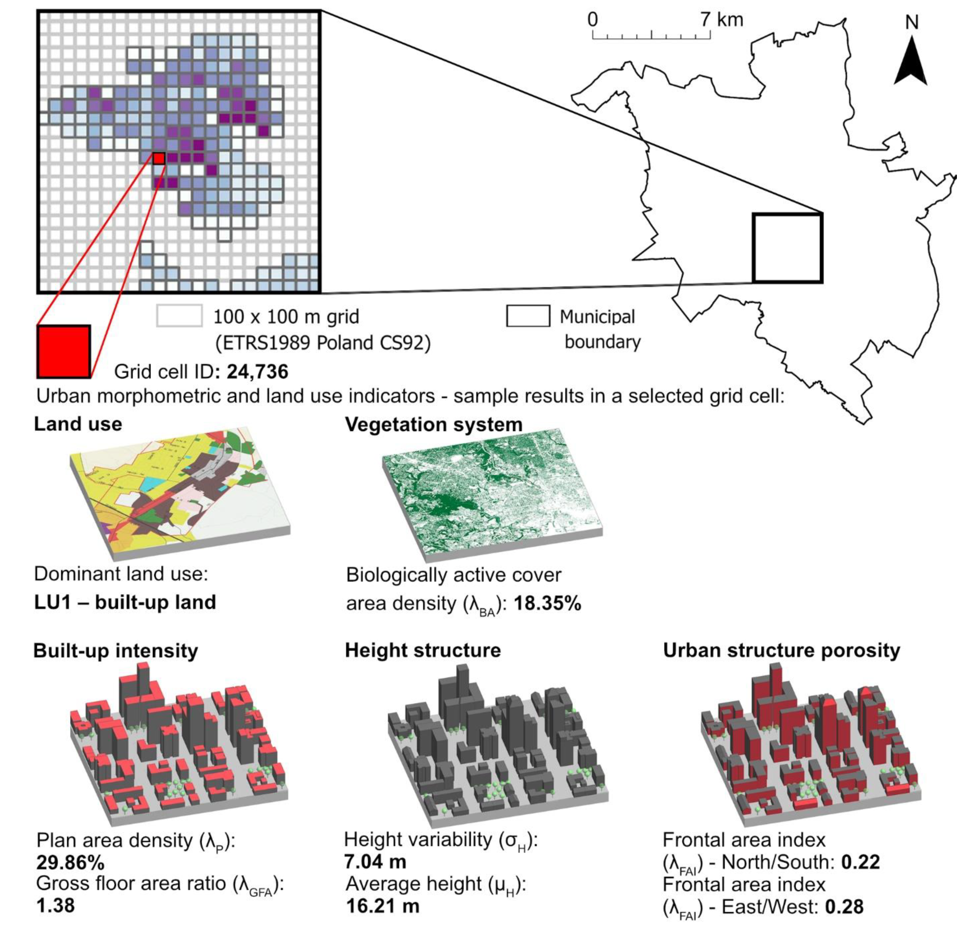
Figure 1. Impact of urban form on urban ventilation at various levels of urban planning and design (authors’ own elaboration, based on the referenced literature).
Sustainability 14 09688 g001
Figure 2. The system of green areas proposed in the Development Plan of Greater Gdańsk [44].
Sustainability 14 09688 g002
Figure 3. Scheme of the green wedges in relation to the residential districts in the city of Warsaw, as presented by Maria Buckiewiczówna (1928) [49].
Sustainability 14 09688 g003
Figure 4. Scheme of green rings and wedges in Poznań by Władysław Czarnecki—concept from 1932, published in his book from the 1960s [57].
Sustainability 14 09688 g004
Figure 5. Concept of satellite settlements with open spaces and connections between them for the city of Wrocław, developed in the 1920s by Ernst May [54].
Sustainability 14 09688 g005
Figure 6. System of green and open spaces in (A) Gdańsk, (B) Warsaw, (C) Poznań and (D) Wrocław (maps—authors’ own elaboration, based on data from the Head Office of Geodesy and Cartography [61], schemes—adapted based on the work in [62]).
Sustainability 14 09688 g006
Figure 7. Workflow for the analysis of the source materials and for monitoring the degree of preservation of the urban systems of green and open spaces.
Sustainability 14 09688 g007
Figure 8. Grid approach used in the GIS study.
Sustainability 14 09688 g008
Figure 9. (A,B) two approaches to calculating the frontal area index. (Authors’ own elaboration, based on: [15,60,86]).
Sustainability 14 09688 g009
Figure 10. Juxtaposition of the historical plan [44] and the current spatial distribution of built-up and open areas in Gdańsk.
Sustainability 14 09688 g010
Figure 11. Juxtaposition of the historical plan [49] and the current spatial distribution of built-up and open areas in Warsaw.
Sustainability 14 09688 g011
Figure 12. Juxtaposition of the historical plan (as presented in [62]) and the current spatial distribution of built-up and open areas in Poznań.
Sustainability 14 09688 g012
Figure 13. Juxtaposition of the historical plan [54] and the current spatial distribution of built-up and open areas in Wrocław.
Sustainability 14 09688 g013
Figure 14. The mapped urban form indicators related to ventilation efficiency in Gdańsk.
Sustainability 14 09688 g014
Figure 15. The mapped urban form indicators related to ventilation efficiency in Warsaw.
Sustainability 14 09688 g015
Figure 16. The mapped urban form indicators related to ventilation efficiency in Poznań.
Sustainability 14 09688 g016
Figure 17. The mapped urban form indicators related to ventilation efficiency in Wrocław.
Sustainability 14 09688 g017
Figure 18. Local case study of the ventilation corridor (wedge) in Poznań.
Sustainability 14 09688 g018
Figure 19. Local case study of the ventilation pathway alongside one of the waterways in Gdańsk.
Sustainability 14 09688 g019
Figure 20. Local case study of the ventilation pathway alongside Partyzantów street in Gdańsk.
Sustainability 14 09688 g020
Figure 21. CFD study of the ventilation pathway alongside Partyzantów street in Gdańsk: (a) existing scenario, (b) alternative design scenario for ventilation efficiency improvement.
Sustainability 14 09688 g021
Table 1. Urban form indicators used in the GIS study to identify the key elements of the ventilation system.
CategoryIndicatorDefinitionRef.
Land useDominant land use (lU) (-)- the dominant land use in the grid cell (that use occupying the largest area) from the land use categories defined in the municipal database: LU1—built-up land, LU2—transport infrastructure (combined road network areas, urban squares, and railway network and airport areas feature classes), LU3—woodland and land covered with high greenery, LU4—land covered with shrubs, LU5—grassland and agricultural land, LU6—surface water, LU7—municipal landfill, LU8—unutilised land, LU9—undeveloped land, LU10—excavation and heap land[75,76]
Vegetation systemBiologically active cover area density (λBA) (%)λBA = ABA/Ac
where ABA is the total footprint area of all biologically active areas (woodland and land covered with high greenery, land covered with shrubs, grassland and agricultural land) in each grid cell, and where Ac is the area of the grid cell
[8,77,78]
Built-up intensityPlan area density (λP) (%)λP = Ap/Ac
where Ap is the total footprint area of all buildings in each grid cell, and where Ac is the area of the grid cell
[8,19,24,79]
Gross floor area ratio (λGFA) (-)λGFA = AGFA/Ac
where AGFA is the total building gross floor area in each grid cell, and where Ac is the area of the grid cell
[8,80,81]
Height structureHeight variability (σH) (m)- calculated as the standard deviation of the buildings’ height in the grid cell[8,19,79]
Average height (μH) (m)- calculated as the average buildings’ height in the grid cell (area weighted)
Urban structure porosityFrontal area index (λFAI) (-)λFAI = AFA/Ac
where AFA is the area of the buildings’ façades facing the given wind direction in each grid cell, and where Ac is the area of the grid cell—the λFAI was calculated for the cardinal wind directions (North–South and East–West) and averaged for each grid cell
[15,79,82,83]
Publisher’s Note: MDPI stays neutral with regard to jurisdictional claims in published maps and institutional affiliations.

