
Identification of Vegetation Coverage Variation and Quantitative the Impact of Environmental Factors on Its Spatial Distribution in the Pisha Sandstone Area

Abstract
:1. Introduction
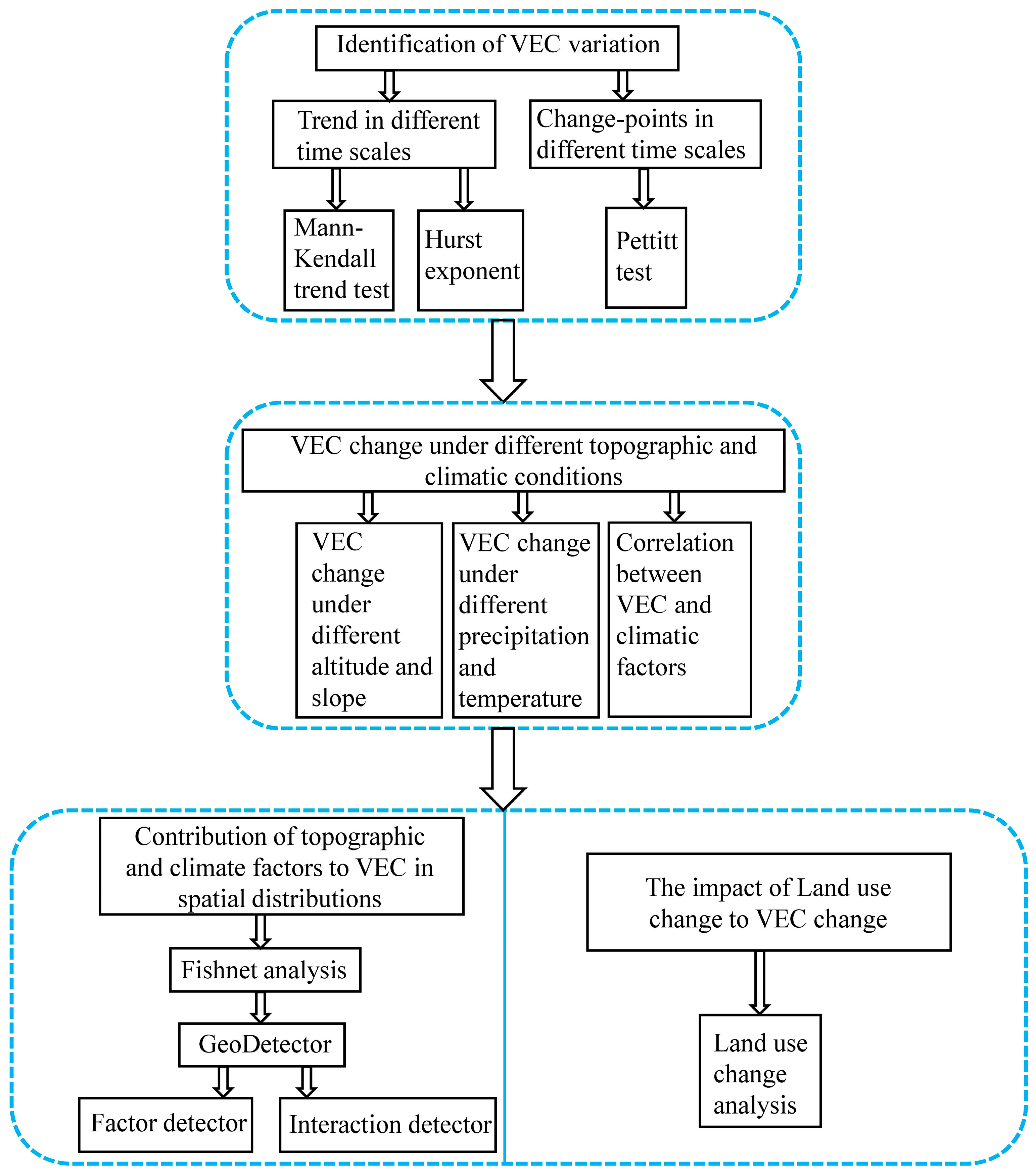
2. Materials and Methods
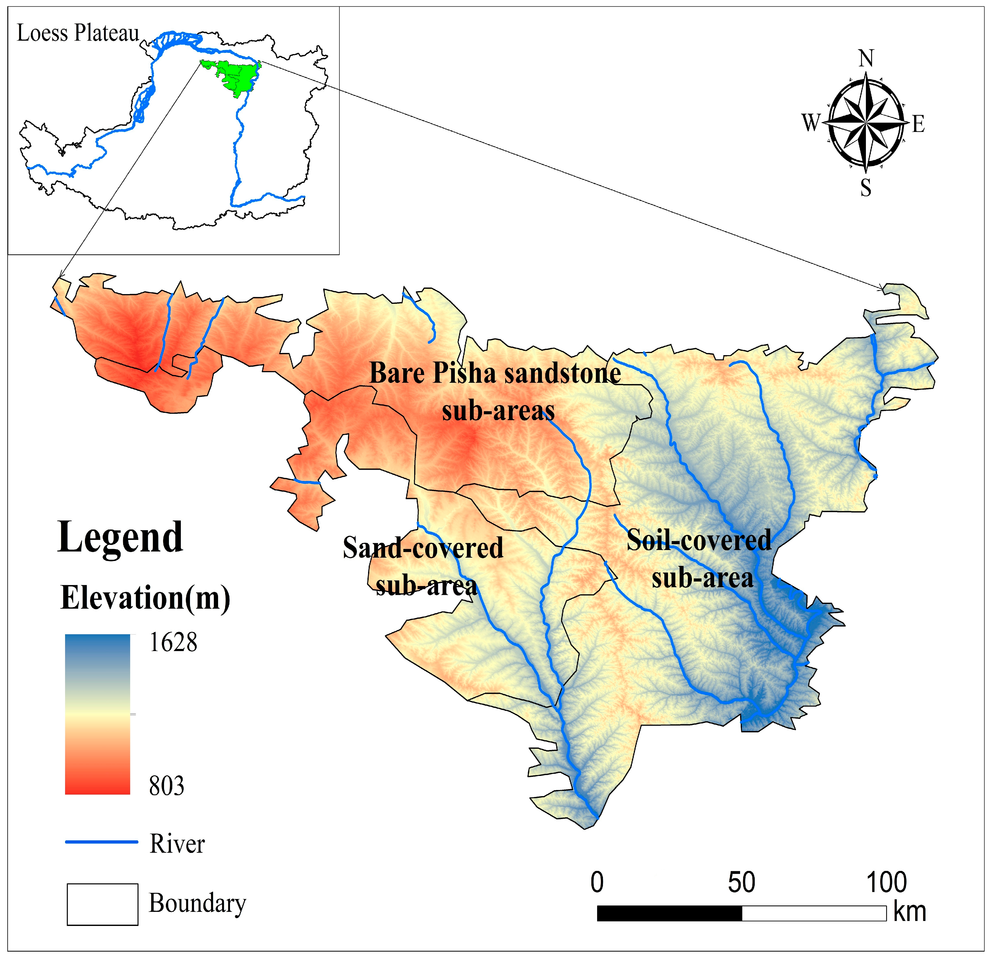
2.1. Study Area and Data
2.2. Methodology
2.2.1. Calculate Vegetation Coverage
2.2.2. Mann–Kendall (MK) Trend Test Method
2.2.3. Hurst Exponent
2.2.4. Pettitt Test
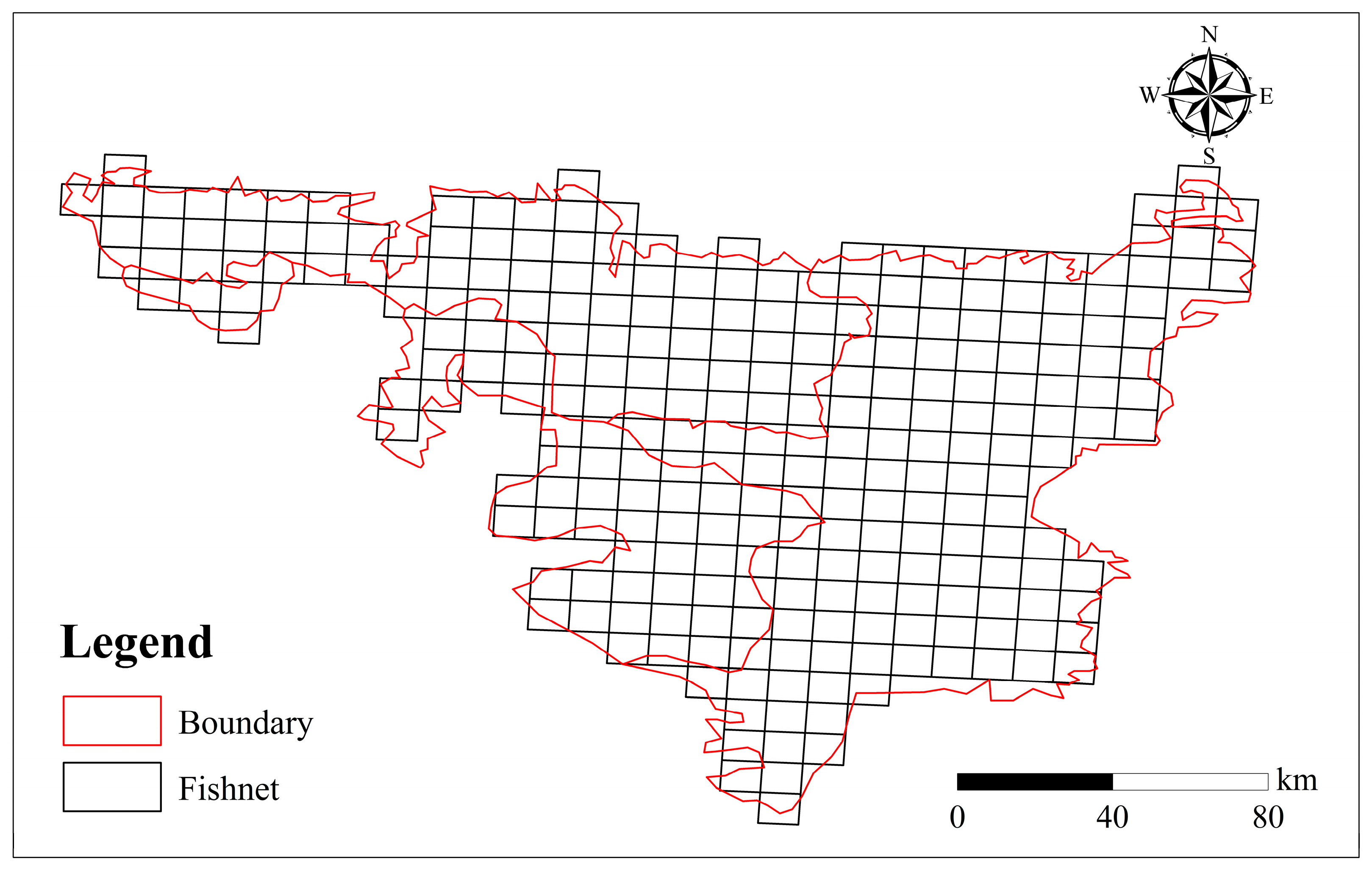
2.2.5. GeoDetector Based on Fishnet Analysis
3. Results
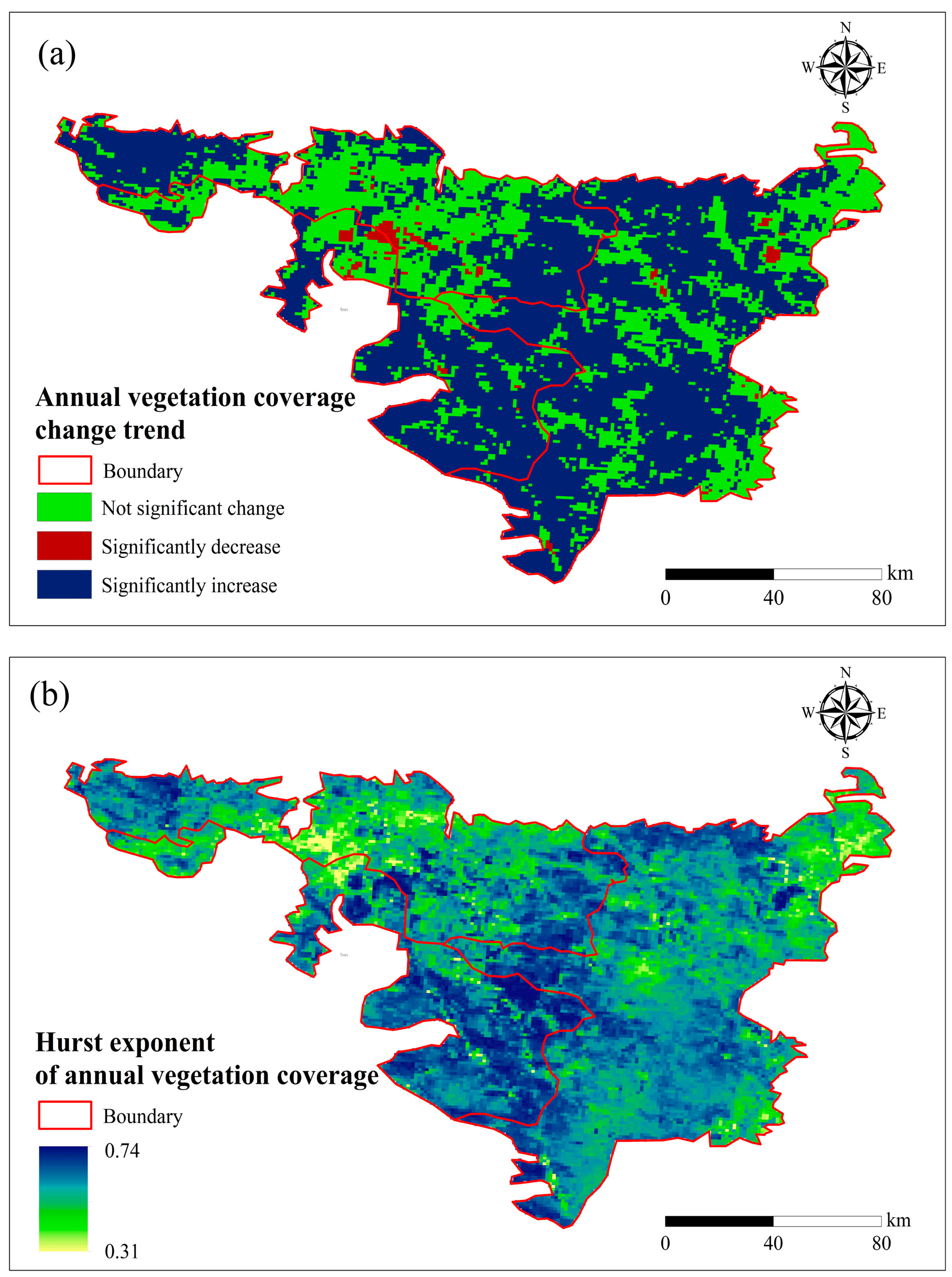
3.1. Trend of VEC
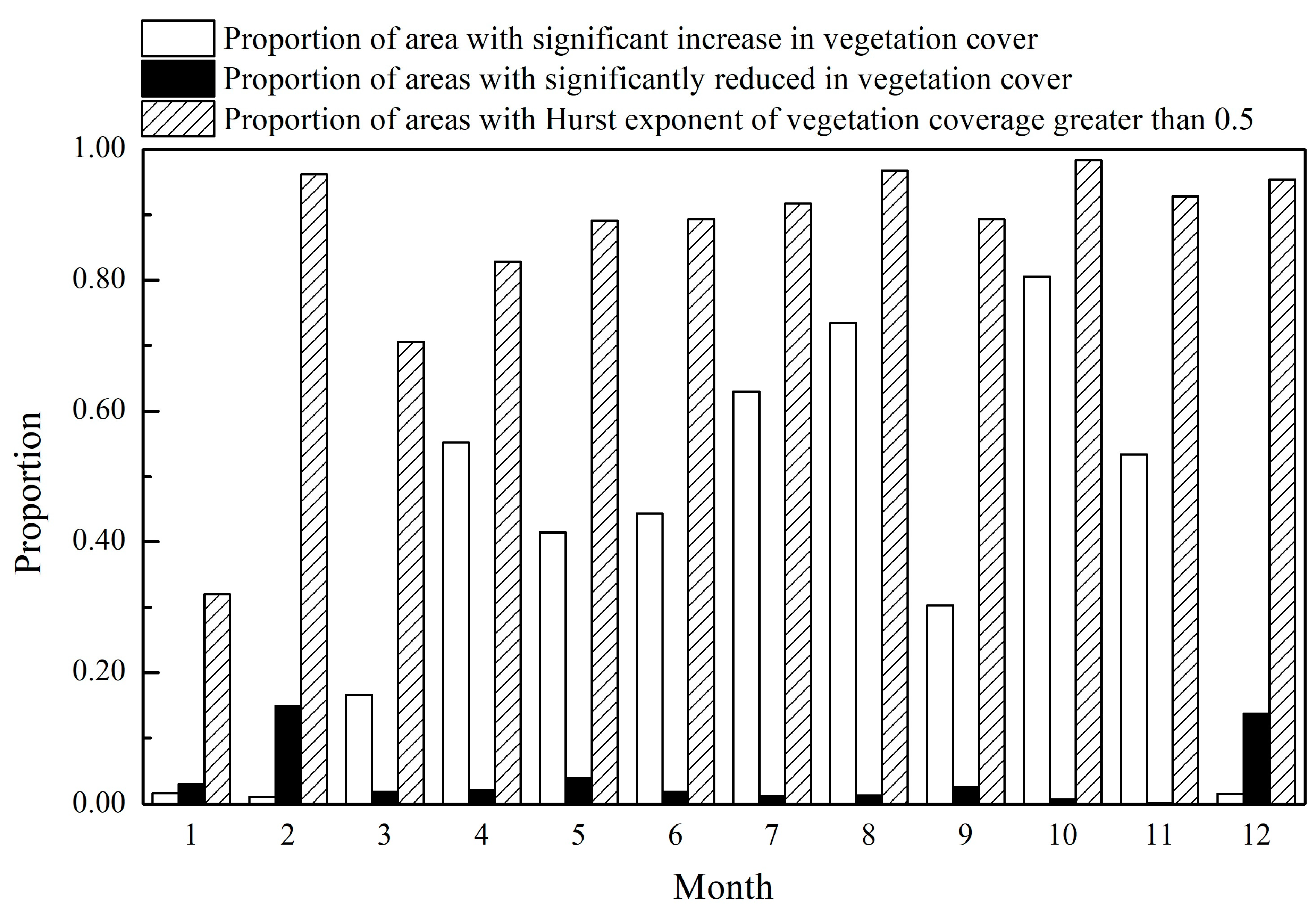
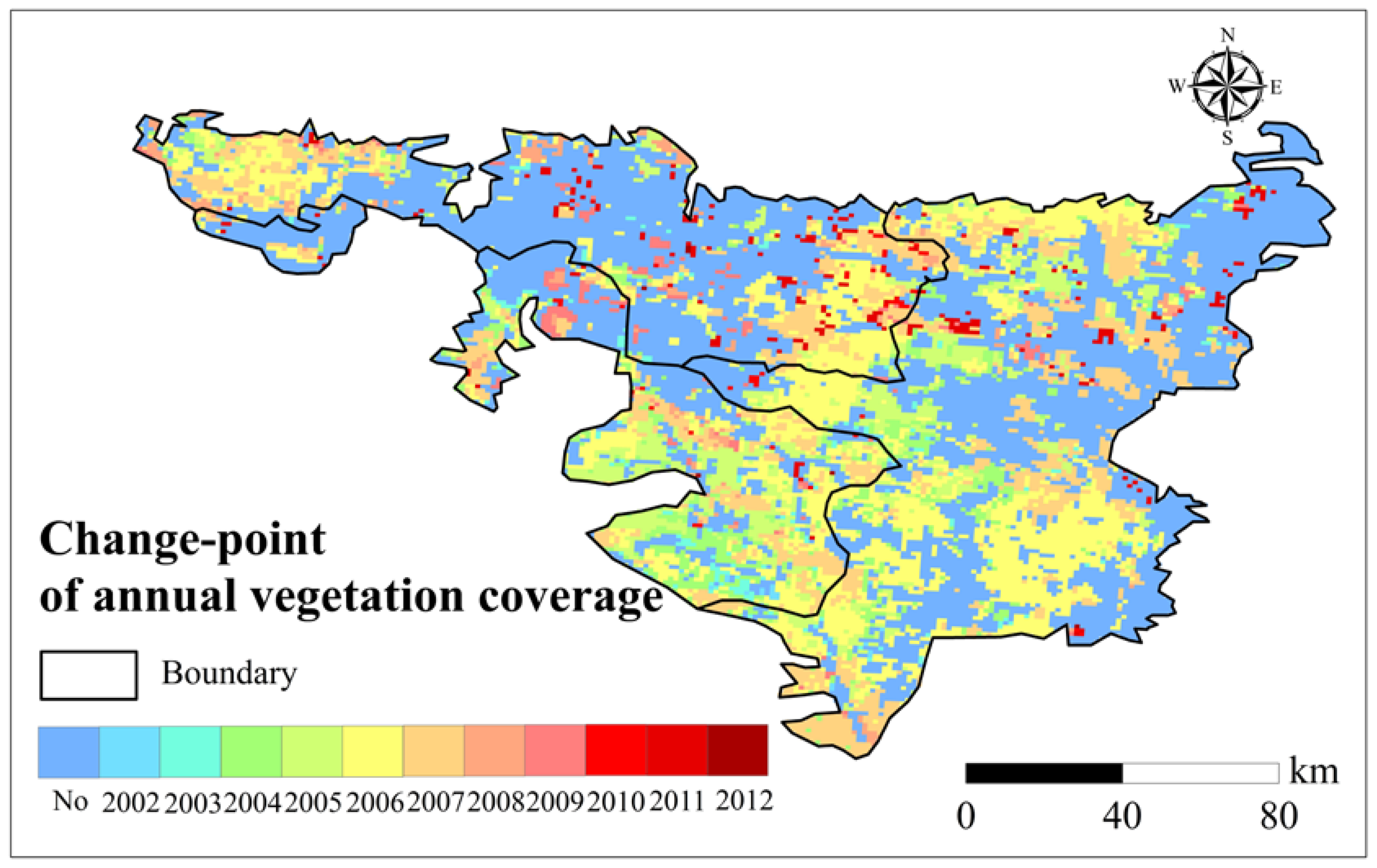
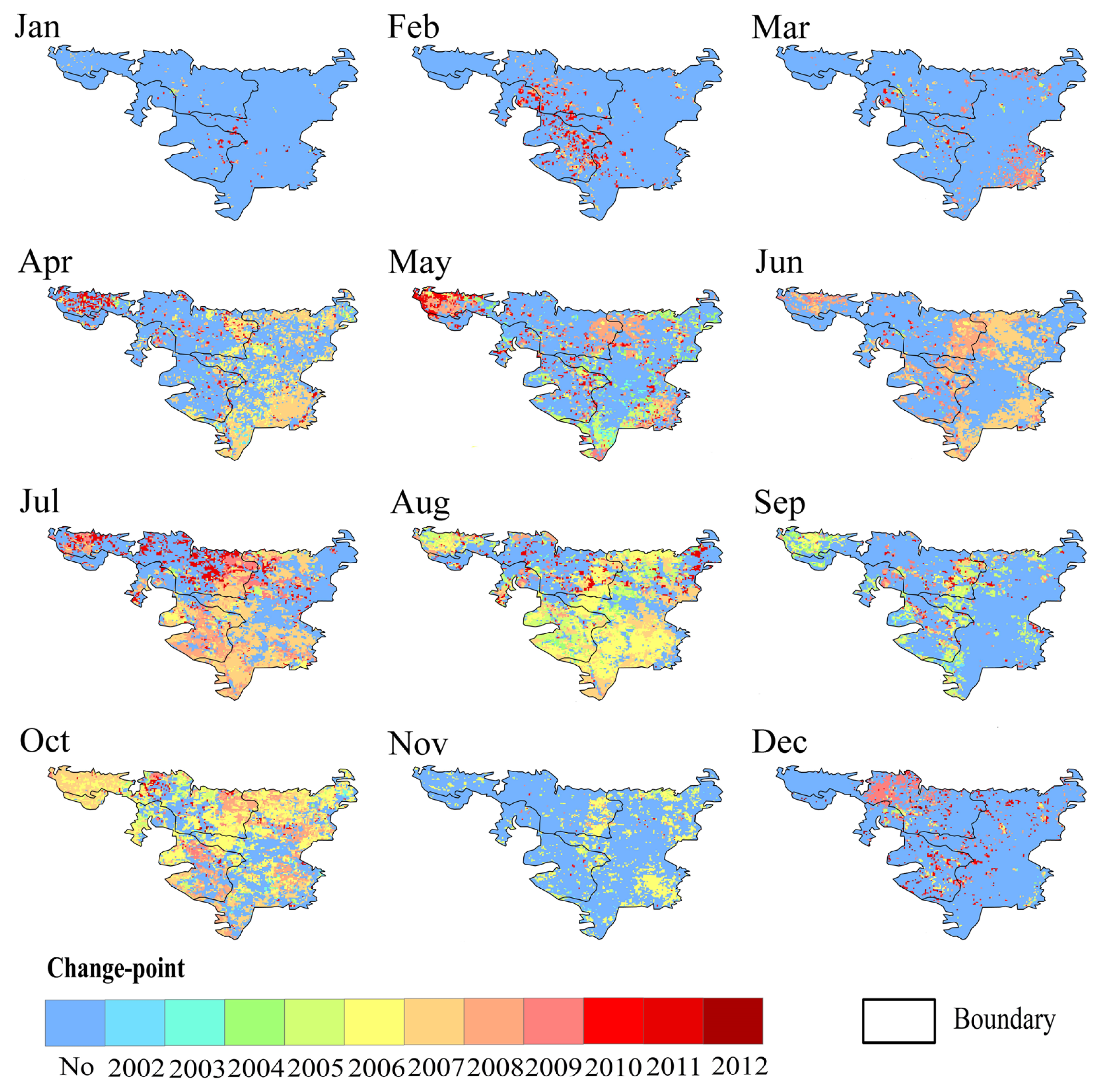
3.2. Identification of Significant Change Points in VEC
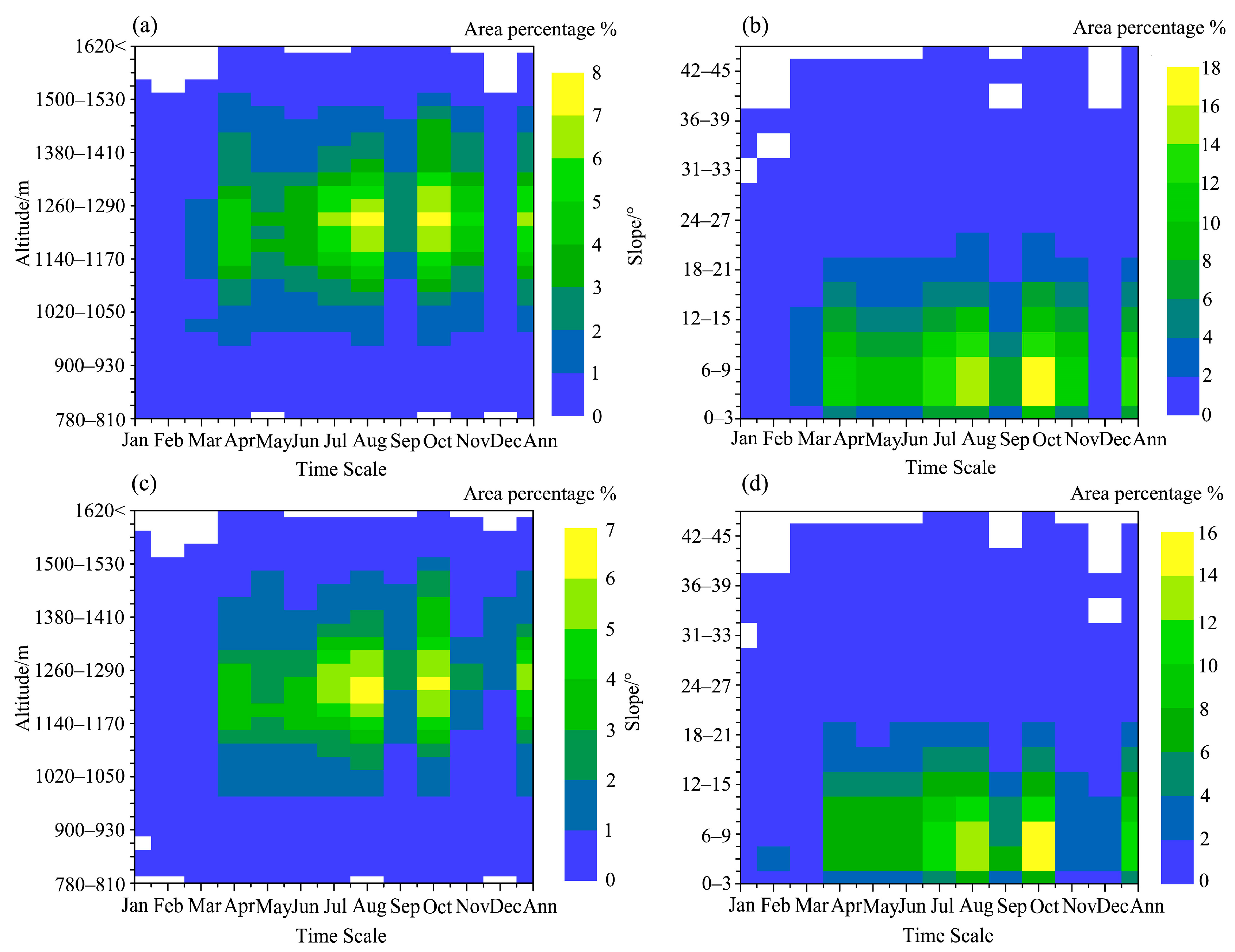
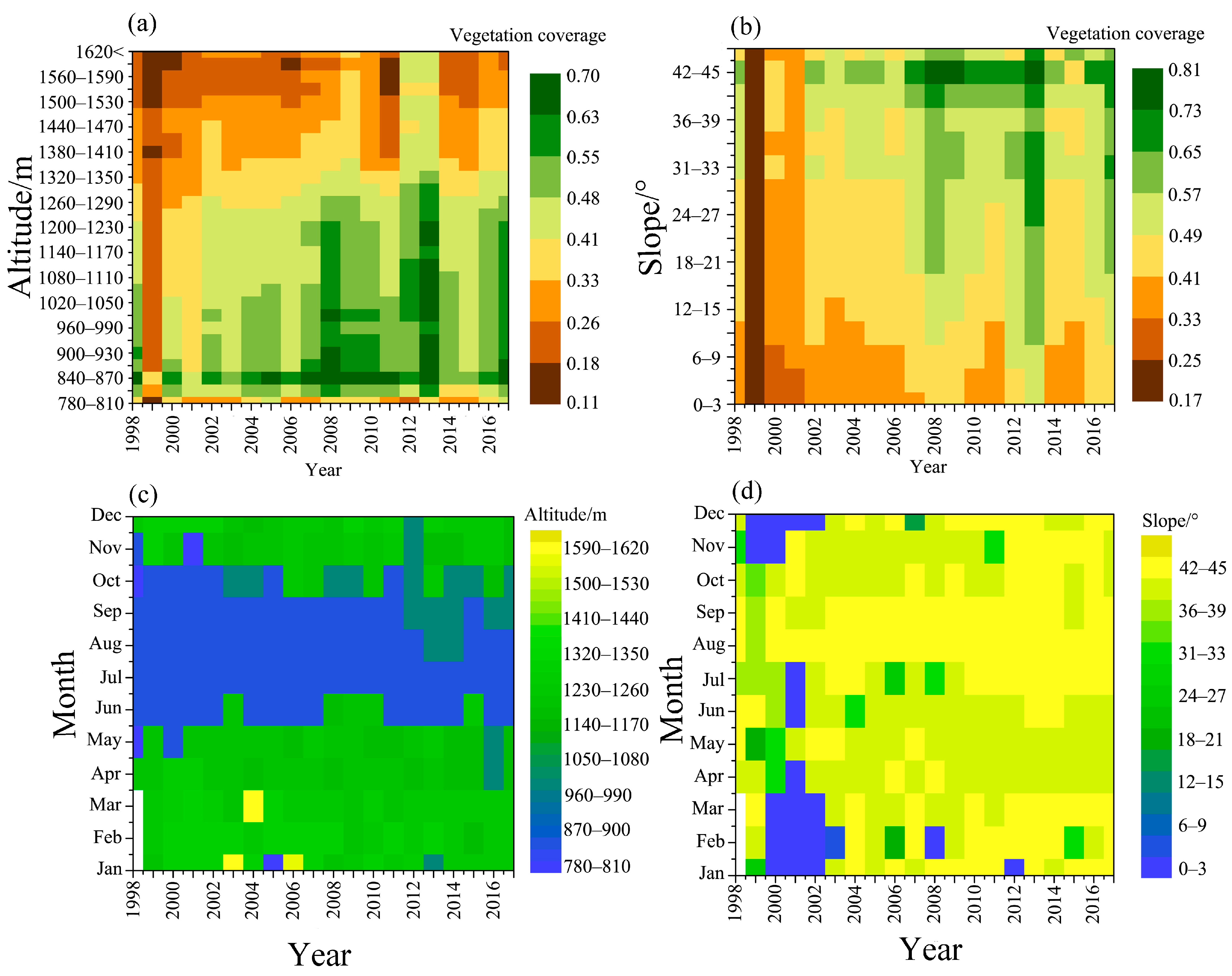
3.3. VEC Changes under Different Topographic Conditions
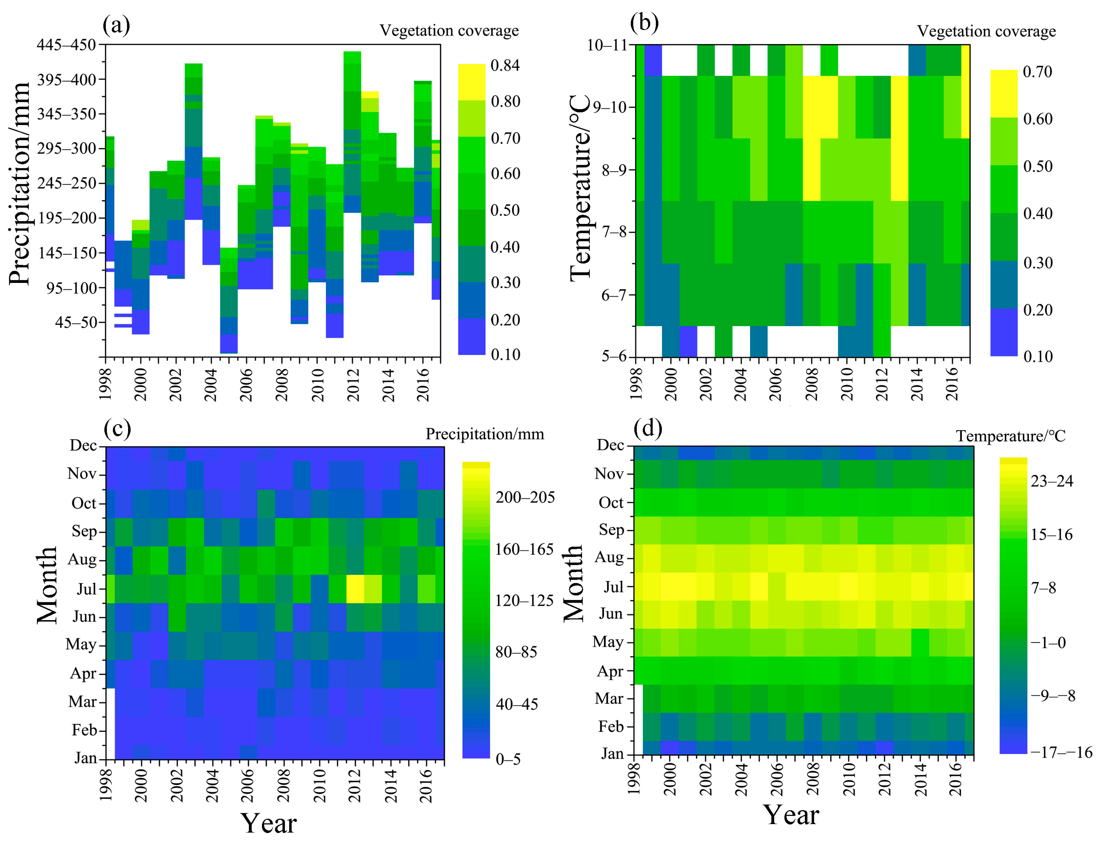
3.4. VEC Change under Different Climatic Conditions
4. Discussion
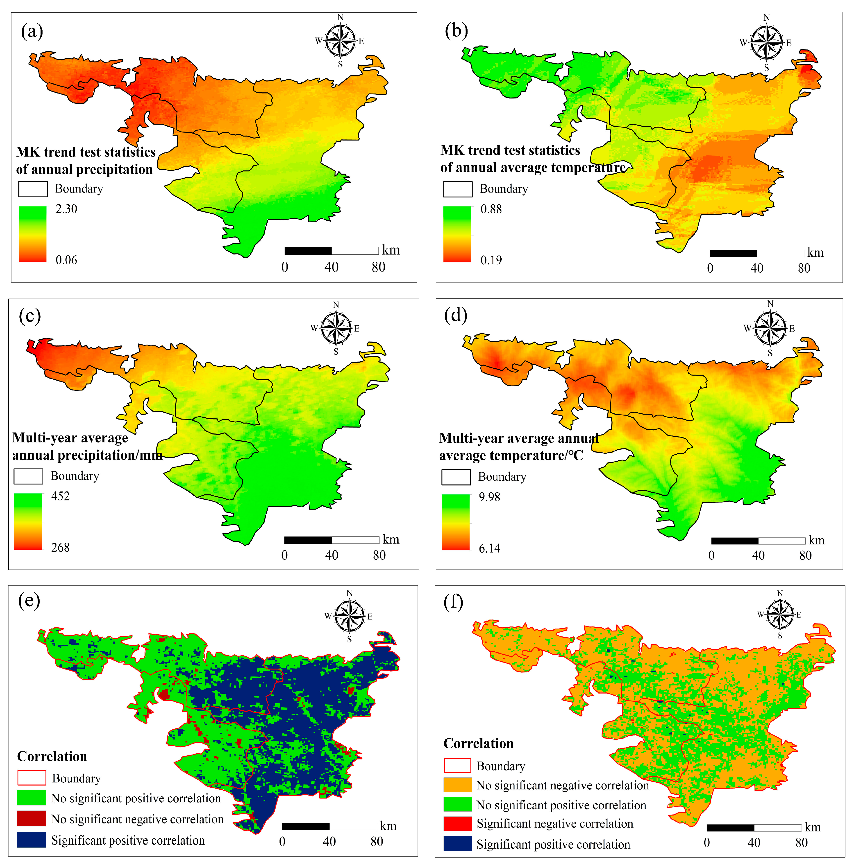
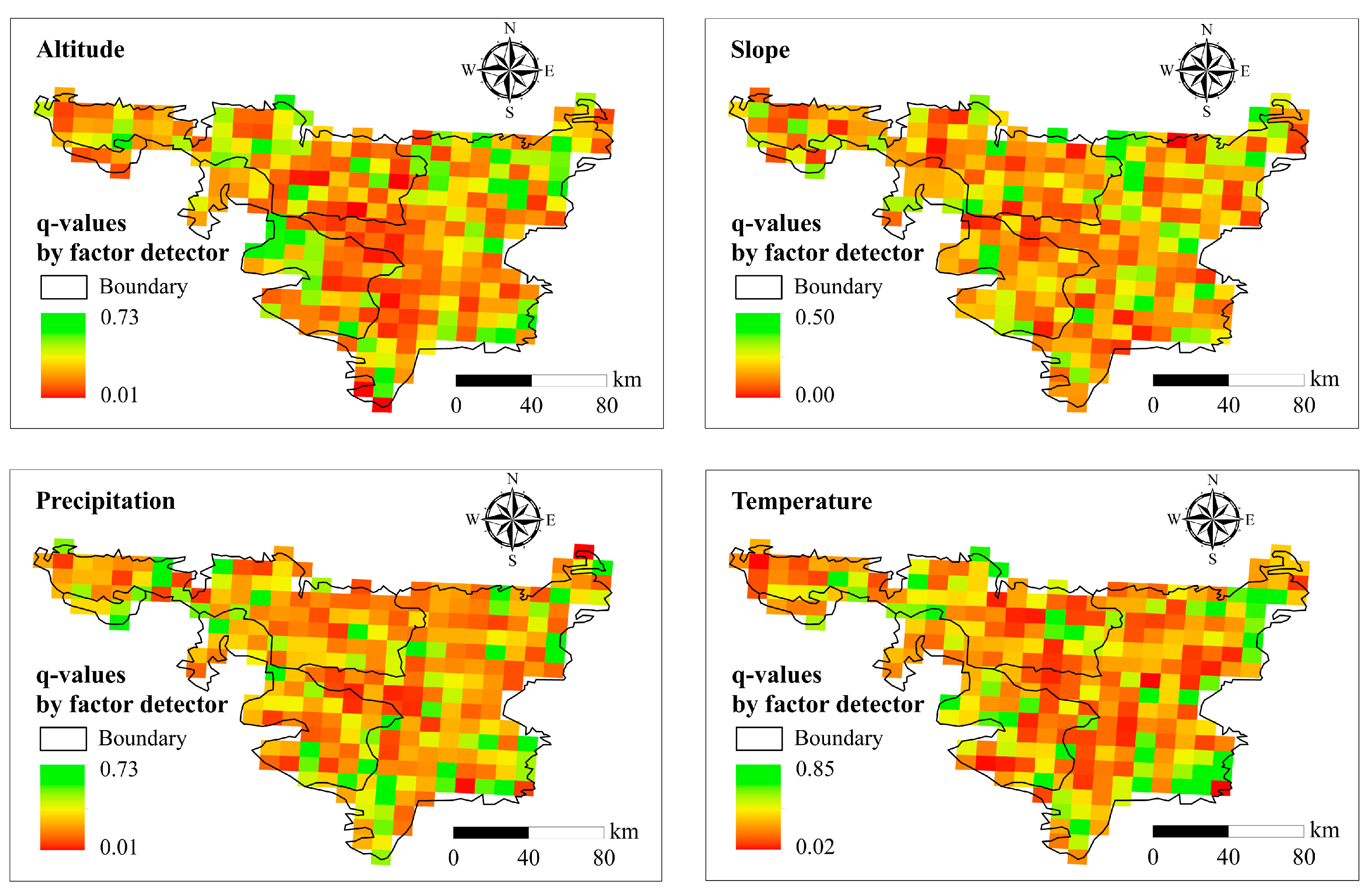
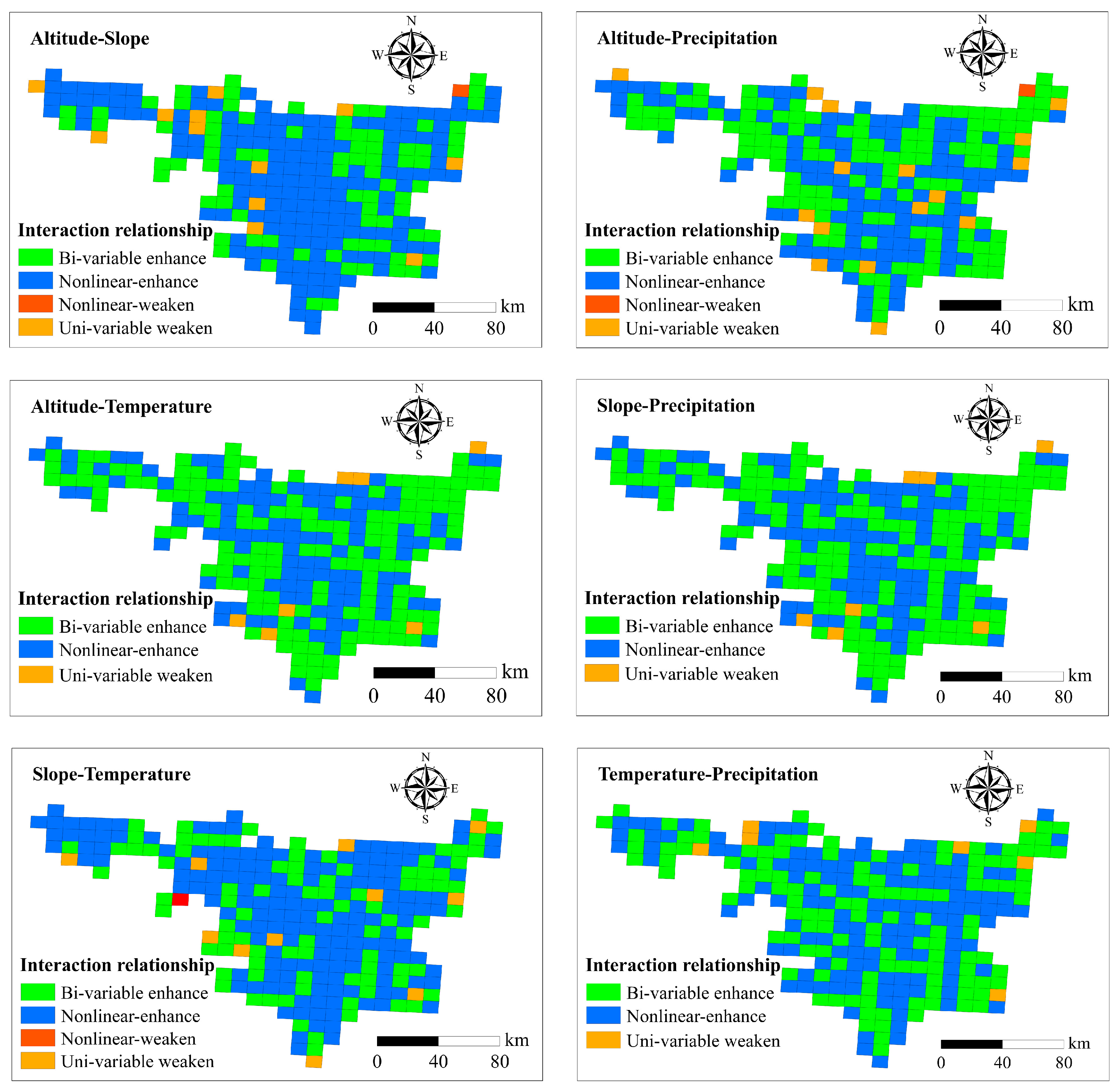
4.1. Contribution of Topographic and Climate Factors to VEC in Spatial Distributions
4.2. The Impact of Land Use Change on VEC Change
5. Conclusions
Author Contributions
Funding
Institutional Review Board Statement
Informed Consent Statement
Data Availability Statement
Conflicts of Interest
References
- Schiml, D.; Melillo, J.; Tian, H.Q.; Kicklighter, D. Contribution of increasing CO2 and climate to carbon storage by ecosystems of the United States. Science 2000, 287, 2004–2006. [Google Scholar] [CrossRef] [PubMed]
- Albani, M.; Medvigy, D.; Hurtt, G.C.; Moorcroft, P.R. The contributions of land-use change, CO2 fertilization, and climate variability to the Eastern US carbon sink. Glob. Change Biol. 2010, 12, 2370–2390. [Google Scholar] [CrossRef]
- Liu, Y.L.; Lei, H.M. Responses of natural vegetation dynamics to climate drivers in China from 1982 to 2011. Remote Sens. 2015, 7, 10243–10268. [Google Scholar] [CrossRef] [Green Version]
- Wen, Z.; Wu, S.; Chen, J.; Lü, M. NDVI indicated long-term interarnnual changes in vegetation activities and their responses to climatic and anthropogenic factors in the Three Gorges Reservoir Region, China. Sci. Total Environ. 2017, 574, 947–959. [Google Scholar] [CrossRef]
- Potter, C.; Boriah, S.; Steinbach, M.; Kumar, V.; Klooster, S. Terrestrial vegetation dynamics and global climate controls. Clim. Dyn. 2008, 31, 67–78. [Google Scholar] [CrossRef]
- Guan, Q.; Yang, L.; Pan, N.; Lin, J.; Xu, C.; Wang, F.; Liu, Z. Greening and browning of the Hexi Corridor in northwest China: Spatial patterns and responses to climatic variability and anthropogenic drivers. Remote Sens. 2018, 10, 1270. [Google Scholar] [CrossRef] [Green Version]
- Piao, S.L.; Fang, J.Y.; Zhou, L.M.; Guo, Q.H.; Henderson, M.; Ji, W.; Li, Y.; Tao, S. Interannual variations of monthly and seasonal NDVI in China from 1982 to 1999. J. Geophys. Res. Atmos. 2003, 108, 4401. [Google Scholar] [CrossRef]
- Wang, Q.; Zhang, Q.P.; Zhou, W. Grassland coverage changes and analysis of driving forces in Maqu country. Int. Conf. Med. Phys. Biomed. Eng. 2012, 33, 1292–1297. [Google Scholar]
- Daham, A.; Han, D.; Rico-Ramirez, M.; Marsh, A. Analysis of NDVI variability in response to precipitation and air temperature in different regions of Iraq, using MODIS vegetation indices. Environ. Earth Sci. 2018, 77, 389. [Google Scholar] [CrossRef] [Green Version]
- Xiao, X.; Ojima, D.S.; Parton, W.J.; Chen, Z.; Chen, D. Sensitivity of Inner Mongolia Grasslands to Climate Change. J. Biogeogr. 1995, 22, 642–648. [Google Scholar] [CrossRef]
- Piao, S.; Mohammat, A.; Fang, J.; Gai, Q.; Feng, J. NDVI-based increase in growth of temperate grasslands and its responses to climate changes in China. Glob. Environ. Change 2006, 16, 340–348. [Google Scholar] [CrossRef]
- Intergovernmental Panel on Climate Change (IPCC). Climate Change 2007: The Physical Science Basis. Contribution of Working Group I to the Fourth Assessment Report of the Intergovernmental Panel on Climate Change; Solomon, S., Qin, D., Manning, M., Averyt, K., Marquis, M., Eds.; Cambridge University Press: Cambridge, UK, 2007. [Google Scholar]
- Ren, G.Y.; Ding, Y.H.; Zhao, Z.C.; Zheng, J.Y.; Wu, T.W.; Tang, G.L.; Xu, Y. Recent progress in studies of climate change in China. Adv. Atmos. Sci. 2012, 29, 958–977. [Google Scholar] [CrossRef]
- Liu, X.F.; Pan, Y.Z.; Zhu, X.F.; Li, S.S. Spatiotemporal variation of vegetation coverage in Qinling-Daba Mountains in relation to environmental factors. J. Geogr. Sci. 2015, 70, 705–716. (In Chinese) [Google Scholar]
- Geerken, R.; Zaitchik, B.; Evans, J.P. Classifying rangeland vegetation type and coverage from NDVI time series using Fourier Filtered Cycle similarity. Int. J. Remote Sens. 2005, 26, 5535–5554. [Google Scholar] [CrossRef]
- Cyr, L.; Bonn, F.; Pesant, A. Vegetation indices derived from remote sensing for an estimation of soil protection against water erosion. Ecol. Model. 1995, 79, 277–285. [Google Scholar] [CrossRef]
- Hupy, J.P. Influence of vegetation cover and crust type on wind-blown sediment in a semi-arid climate. J. Arid. Environ. 2004, 58, 167–179. [Google Scholar] [CrossRef]
- Zhou, Z.C.; Shangguan, Z.P.; Zhao, O.L. Modeling vegetation coverage and soil erosion in the Loess Plateau Area of China. Ecol. Model. 2006, 198, 263–268. [Google Scholar] [CrossRef]
- Peng, J.; Liu, Z.; Liu, Y.; Wu, J.; Han, Y. Trend analysis of vegetation dynamics in Qinghai-Tibet Plateau using Hurst Exponent. Ecol. Indic. 2012, 14, 28–39. [Google Scholar] [CrossRef]
- Yu, Z. Assessing the reponse of subgrid hydrologic processes to atmospheric forcing with a hydrologic model system. Glob. Planet. Change 2000, 25, 1–17. [Google Scholar] [CrossRef]
- Suzuki, R.; Masuda, K.; Dye, G. Interannual covariability between actual evapotranspiration and PAL and GIMMS NDVIs of Northem Asia. Remote Sens. Environ. 2007, 106, 387–398. [Google Scholar] [CrossRef]
- Zawadzki, J.; Cieszewski, C.J.; Zasada, M.; Lowe, R.C. Applying geostatistics for investigations of forest ecosystems using remote sensing imagery. Silva Fenn. 2005, 39, 599–617. [Google Scholar] [CrossRef] [Green Version]
- Huete, A. Ecology: Vegetation’s responses to climate variability. Nature 2016, 531, 181–182. [Google Scholar] [CrossRef] [PubMed] [Green Version]
- Tucker, C.J.; Slayback, D.A.; Pinzon, J.E.; Los, S.O.; Myneni, R.B.; Taylor, M.G. Higher northern latitude normalized difference vegetation index and growing season trends from 1982 to 1999. Int. J. Biometeorol. 2001, 45, 184–190. [Google Scholar] [CrossRef] [PubMed]
- Chu, H.S.; Venevsky, S.; Wu, C.; Wang, M.H. NDVI–based vegetation dynamics and its response to climate changes at Amur-Heilongjiang River Basin from 1982 to 2015. Sci. Total Environ. 2019, 650 Pt 2, 2051–2062. [Google Scholar] [CrossRef] [PubMed]
- Du, J.Q.; Shu, J.M.; Yin, J.Q.; Yuan, X.J.; Jiaerheng, A.; Xiong, S.S.; He, P.; Liu, W.L. Analysis on spatio–temporal trends and drivers in vegetation growth during recent decades in Xinjiang, China. Int. J. Appl. Earth Obs. Geoinf. 2015, 38, 216–228. [Google Scholar] [CrossRef]
- Jiang, L.; Jiapaer, G.; Bao, A.; Guo, H.; Ndayisaba, F. Vegetation dynamics and responses to climate change and human activities in Central Asia. Sci. Total Environ. 2017, 599, 967–980. [Google Scholar] [CrossRef] [PubMed]
- Piao, S.L.; Wang, X.H.; Ciais, P.; Zhu, B.; Wang Tao Liu, J. Changes in satellite-derived vegetation growth trend in temperate and boreal Eurasia from 1982 to 2006. Glob. Change Biol. 2011, 17, 3228–3239. [Google Scholar] [CrossRef]
- Fensholt, R.; Langanke, T.; Rasmussen, K.; Reenberg, A.; Prince, S.D.; Tucker, C.; Scholes, R.J.; Le, Q.B.; Bondeau, A.; Eastman, R. Greenness in semi-arid areas across the globe 1981–2007—An earth observing satellite based analysis of trends and drivers. Remote Sens. Environ. 2012, 121, 144–158. [Google Scholar] [CrossRef]
- Xu, G.C.; Zhang, J.X.; Li, P.; Li, Z.B.; Lu, K.X.; Wang, X.K.; Wang, F.C.; Cheng, Y.T.; Wang, B. Vegetation restoration projects and their influence on runoff and sediment in China. Ecol. Indic. 2018, 95, 233–241. [Google Scholar] [CrossRef]
- Sun, Y.Y.; Yang, Y.L.; Zhang, Y.; Wang, Z.L. The relative roles of climate variations and human activities in vegetation change in North China. Phys. Chem. Earth Parts A/B/C 2015, 87, 67–78. [Google Scholar] [CrossRef]
- Jingyun, F.; Shilong, P.; Jinsheng, H.E.; Wenhong, M.A. Increasing terrestrial vegetation activity in China, 1982–1999. Sci. China 2004, 47, 229–240. [Google Scholar]
- Myneni, R.B.; Keeling, C.D.; Tucker, C.J.; Asrar, G.; Nemani, R.R. Increased plant growth in the northern high latitudes from 1981 to 1991. Nature 1997, 386, 698–702. [Google Scholar] [CrossRef]
- Park, H.S.; Sohn, B.J. Recent trends in changes of vegetation over east Asia coupled with temperature and rainfall variations. J. Geophys. Res. Atmos. 2010, 115, D14101. [Google Scholar] [CrossRef]
- Wang, B.; Xu, G.C.; Li, P.; Li, Z.B.; Zhang, Y.X.; Cheng, Y.T.; Jia, L.; Zhang, J.X. Vegetation dynamics and their relationships with climatic factors in the Qinling mountains of China. Ecol. Indic. 2020, 108, 105719. [Google Scholar] [CrossRef]
- Shi, S.H.; Wang, X.L.; Hu, Z.R.; Zhao, X.; Zhang, S.R.; Hou, M.; Zhang, N. Geographic detector-based quantitative assessment enhances attribution analysis of climate and topography factors to vegetation variation for spatial heterogeneity and coupling. Glob. Ecol. Conserv. 2023, 42, e02398. [Google Scholar] [CrossRef]
- Wang, T.; Li, P.; Li, Z.B.; Hou, J.M.; Xiao, L.; Ren, Z.P.; Xu, G.C.; Yu, K.X.; Su, Y.Y. The effects of freeze–thaw process on soil water migration in dam and slope farmland on the Loess Plateau, China. Sci. Total Environ. 2019, 666, 721–730. [Google Scholar] [CrossRef]
- Wang, T.; Li, P.; Liu, Y.; Hou, J.M.; Li, Z.B.; Ren, Z.P.; Cheng, S.D.; Zhao, J.H.; Reinhard, H. Experimental investigation of freeze-thaw meltwater compound erosion and runoff energy consumption on loessal slopes. Catena 2020, 185, 104310. [Google Scholar] [CrossRef]
- Jia, L.; Yu, K.X.; Li, Z.B.; Li, P.; Zhang, J.Z.; Wang, A.N.; Ma, L.; Xu, G.C.; Zhang, X. Temporal and spatial variation of rainfall erosivity in the Loess Plateau of China and its impact on sediment load. Catena 2022, 210, 105931. [Google Scholar] [CrossRef]
- Du, R.Z.; Li, W.D.; Gao, W.H.; Fu, J.X.; Qi, Y.B.; Li, Z. Influence of climate and surface cover changes on spatiotemporal changes of wind erosion in Pisha sandstone area. Aci Mater. J. 2023, 30, 5. [Google Scholar]
- Zhen, Q.; Zheng, J.Y.; He, H.H.; Zhang, X. Effects of Pisha sandstone content on solute transport in a sandy soil. Chemosphere 2016, 144, 2214–2220. [Google Scholar] [CrossRef]
- Dong, J.J.; Wang, L.J.; Zhang, T.T. Study on the strength development, hydration process and carbonation process of NaOH-activated Pisha Sandstone. Constr. Build. Mater. 2014, 66, 154–162. [Google Scholar] [CrossRef]
- Yang, J.; Huang, X. The 30 m annual land cover dataset and its dynamics in China from 1990 to 2019. Earth Syst. Sci. Data 2021, 13, 3907–3925. [Google Scholar] [CrossRef]
- Jia, L.; Li, Z.B.; Xu, G.C.; Ren, Z.P.; Yu, S. Dynamic change of vegetation and its response to climate and topographic factors in the Xijiang River Basin, China. Environ. Sci. Pollut. Res. 2020, 27, 11637–11648. [Google Scholar] [CrossRef] [PubMed]
- Mann, H.B. Nonparametric test against trend. Econometrica 1945, 13, 245–259. [Google Scholar] [CrossRef]
- KendaIl, M.G. Rank Correlation Methods; Griffin: London, UK, 1975. [Google Scholar]
- Zhang, X.C.; Jin, X.M. Vegetation dynamics and responses to climate change and anthropogenic activities in the Three-River Headwaters Region, China. Ecol. Indic. 2021, 131, 108223. [Google Scholar] [CrossRef]
- Pettitt, A.N. A non-parametric approach to the change-point problem. J. R. Stat. Soc. 1979, 28, 126–135. [Google Scholar] [CrossRef]
- Liu, X.Q.; Wang, H.; Wang, X.P.; Bai, M.; He, D.H. Driving factors and their interactions of carabid beetle distribution based on the geographical detector method. Ecol. Indic. 2021, 133, 108393. [Google Scholar] [CrossRef]
- Song, Y.Z.; Wang, J.F.; Ge, Y.; Xu, C.D. An optimal parameters-based geographical detector model enhances geographic characteristics of explanatory variables for spatial heterogeneity analysis: Cases with different types of spatial data. GIScience Remote Sens. 2020, 57, 593–610. [Google Scholar] [CrossRef]
- Ma, X.N.; Ren, Z.P.; Xie, M.Y.; Li, Z.B.; Li, P.; Zhang, X. Quantitative analysis of environmental driving factors of vegetation coverage in the Pisha sandstone area based on geodetector. Acta Ecol. Sin. 2022, 42, 3389–3399. [Google Scholar]
- White, A.B.; Kumar, P.; Tcheng, D. A data mining approach for understanding topographic control on climate-induced inter-annual vegetation variability over the United States. Remote Sens. Environ. 2005, 98, 1–20. [Google Scholar] [CrossRef]
- Jobbagy, E.G.; Sala, O.E.; Paruelo, J.M. Patterns and controls of primary production in the Patagonian steppe: A remote sensing approach. Ecology 2002, 83, 307–319. [Google Scholar]
- Zhou, L. Relation between interannual variations in satellite measures of northern forest greenness and climate between 1982 and 1999. J. Geophys. Res. Atmos. 2003, 108, ACL-1–ACL-3-16. [Google Scholar] [CrossRef] [Green Version]
- Xu, X.; Chen, H.; Levy, J.K. Spatiotemporal vegetation cover variations in the Qinghai-Tibet Plateau under global climate change. Chin. Sci. Bull. 2008, 53, 915–922. [Google Scholar] [CrossRef] [Green Version]
- Cao, R.; Jiang, W.; Yuan, L.; Wang, W.; Lv, Z.; Chen, Z. Inter-annual variations in vegetation and their response to climatic factors in the upper catchments of the Yellow River from 2000 to 2010. J. Geogr. Sci. 2014, 24, 963–979. [Google Scholar] [CrossRef] [Green Version]
- Zheng, K.; Wei, J.Z.; Pei, J.Y.; Cheng, H.; Zhang, X.L.; Huang, F.Q.; Li, F.M.; Ye, J.S. Impacts of climate change and human activities on grassland vegetation variation in the Chinese Loess Plateau. Sci. Total Environ. 2019, 660, 236–244. [Google Scholar] [CrossRef]
- Meixler, M.S.; Kennish, M.J.; Crowley, K.F. Assessment of plant community characteristics in natural and human-altered coastal marsh ecosystems. Estuar. Coast. Shelf Sci. 2018, 41, 52–64. [Google Scholar] [CrossRef]
- Sun, Y.; Yang, Y.; Zhang, Y.; Wang, Z. Assessing vegetation dynamics and their relationships with climatic variability in Northem China. Phys. Phys. Chem. Earth Parts A/B/C 2015, 87, 79–86. [Google Scholar] [CrossRef]
- Sun, W.; Song, X.; Mu, X.; Gao, P.; Wang, F.; Zhao, G. Spatiotemporal vegetation cover variations associated with climate change and ecological restoration in the Loess Plateau. Agric. For. Meteorol. 2015, 209, 87–99. [Google Scholar] [CrossRef]
- Xu, G.C.; Cheng, Y.T.; Zhao, C.Z.; Mao, J.S.; Li, Z.B.; Jia, L.; Zhang, Y.X.; Wang, B. Effects of driving factors at multi-spatial scales on seasonal runoff and sediment changes. Catena 2023, 222, 106867. [Google Scholar] [CrossRef]
- Donohue, R.J.; Roderick, M.L.; McVicar, T.R. On the importance of including vegetation dynamics in Budyko’s hydrological model. Hydrol. Earth Syst. Sci. 2007, 11, 983–995. [Google Scholar] [CrossRef] [Green Version]
- Cao, S.; Chen, L.; Shankman, D.; Wang, C.; Wang, X.; Zhang, H. Excessive reliance on afforestation in china’s arid and semi-arid regions: Lessons in ecological restoration. Earth Sci. Rev. 2011, 104, 240–245. [Google Scholar] [CrossRef]


| Land Use | Rate of Change in the Entire PSA | Rate of Change in the BSA | Rate of Change in the SASA | Rate of Change in the SOSA |
|---|---|---|---|---|
| Cropland | −7.26% | −0.85% | −0.74% | −5.68% |
| Forest | 0.06% | 0.01% | 0.03% | 0.03% |
| Grassland | 8.89% | 2.12% | 1.39% | 5.37% |
| Water | 0.04% | 0.01% | 0.03% | 0.01% |
| Barren | −3.23% | −1.47% | −1.20% | −0.56% |
| Impervious | 1.50% | 0.18% | 0.49% | 0.83% |
Disclaimer/Publisher’s Note: The statements, opinions and data contained in all publications are solely those of the individual author(s) and contributor(s) and not of MDPI and/or the editor(s). MDPI and/or the editor(s) disclaim responsibility for any injury to people or property resulting from any ideas, methods, instructions or products referred to in the content. |
© 2023 by the authors. Licensee MDPI, Basel, Switzerland. This article is an open access article distributed under the terms and conditions of the Creative Commons Attribution (CC BY) license (https://creativecommons.org/licenses/by/4.0/).
Share and Cite
Jia, L.; Yu, K.; Li, Z.; Ren, Z.; Li, H.; Li, P. Identification of Vegetation Coverage Variation and Quantitative the Impact of Environmental Factors on Its Spatial Distribution in the Pisha Sandstone Area. Sustainability 2023, 15, 6054. https://0-doi-org.brum.beds.ac.uk/10.3390/su15076054
Jia L, Yu K, Li Z, Ren Z, Li H, Li P. Identification of Vegetation Coverage Variation and Quantitative the Impact of Environmental Factors on Its Spatial Distribution in the Pisha Sandstone Area. Sustainability. 2023; 15(7):6054. https://0-doi-org.brum.beds.ac.uk/10.3390/su15076054
Chicago/Turabian StyleJia, Lu, Kunxia Yu, Zhanbin Li, Zongping Ren, Hongtao Li, and Peng Li. 2023. "Identification of Vegetation Coverage Variation and Quantitative the Impact of Environmental Factors on Its Spatial Distribution in the Pisha Sandstone Area" Sustainability 15, no. 7: 6054. https://0-doi-org.brum.beds.ac.uk/10.3390/su15076054