


Local Context of Climate Change Adaptation in the South-Western Coastal Region of Bangladesh

1
Climate Change and Sustainable Development Policies, University of Lisbon & Nova University of Lisbon, 1099-085 Lisbon, Portugal
2
Institute of Social Sciences, University of Lisbon, Av. Prof. Aníbal Bettencourt 9, 1600-189 Lisbon, Portugal
3
Norwich Research Park, University of East Anglia, Norwich NR4 7TJ, UK
4
Department of Geography, University of Valencia, Av. Blasco Ibáñez, 28, 46010 Valencia, Spain
5
Department of Anthropology, University of Chittagong, Chattogram 4000, Bangladesh
Sustainability 2023, 15(8), 6664; https://0-doi-org.brum.beds.ac.uk/10.3390/su15086664
Submission received: 8 January 2023
/
Revised: 16 February 2023
/
Accepted: 13 March 2023
/
Published: 14 April 2023
(This article belongs to the Special Issue Addressing Climate Change Impacts on the Sustainable Provision of Transport Infrastructure and Services)
Abstract
:This study was conducted in 12 unions of the Shyamnagar upazila in the Shatkira District, located in the south-western coastal region of Bangladesh (SWCRB). The inhabitants of the SWCRB are affected by different climate-influenced events such as high-intensity cyclones, saltwater intrusion, sea-level rise, and weather pattern-affected agriculture. This study focused on how the local inhabitants are coping with climate change using multilevel adaptation. A mixed approach of data collection, including quantitative and qualitative data, was followed for both primary and secondary sources. Individual-level data collection, key informant interviews, close-ended questions, focus groups, life history of SWCRB residents, and workshops were used to understand vulnerability and social perceptions at the local level. The findings indicated that multiple adaptation practices are employed by people in the SWCRB, such as rainwater harvesting, plantation of different rice varieties, gardening of indigenous vegetables, and pond sand filtering. However, the construction of multipurpose cyclone shelters along with coastal afforestation contributes to building resilience in the SWRCB from the socio-economic and environmental perspectives. Therefore, this study will help to find the most adequate strategy for climate change adaptation and sustainability.
1. Introduction
Adaptation is the process by which local communities, such as those in the south-western coastal region of Bangladesh (SWCRB), deal with new challenges such as climate change. Specifically, it involves a holistic approach to increase resilience towards shocks and risks, which may not, consequently, cause greater or equally negative impacts on the community [1]. During the 20th century, and even in the 21st century, major climate change events have taken place, including rising sea level, temperature increase, changing rainfall patterns, and reduction of ice and snow [2], causing direct drastic impacts on the global ecosystem, and such problems still exist in the SWCRB.
The concept of adaptation is considerably new in the field of climate change, as the mitigation of Greenhouse gases (GHGs) has received significant attention from policymakers and scientists in the past two decades. Since the Marrakech Accords of 2001, adaptation methods have gained momentum in climate change negotiations [3]. However, the AR6 report from the Intergovernmental Panel on Climate Change (IPCC) on the significance of adaptation stated that adaptation keeps a footmark in diminishing acquaintance and vulnerability to climate change [2].
Environmental adaptation requires evolutionary progressions, and, for humans, this encompasses pre-emptive and sensitive natural transformations. With climate change, for instance, there are features that influence adaptation changes, especially when it comes to socio-ecological arrangements of these changes [2]. Adaptation is defined as the process to adjust to real or anticipated climate changes and their impacts, with preparation of damage or gain of useful prospects. In a natural context, adaptation is the procedure of adjustment to real climate and its consequences through human interference [2]. Thus, adaptation is an option for the people who will be affected by climate change, such as the inhabitants of the South Asian region [4].
The IPCC working group WGII’s latest report on Impacts, Adaptation, and Vulnerability [2] clarifies different types of adaptation: incremental or gradual slow rate adaptation; adaptation that sustains or progresses the crux and veracity of a structure at a specified gauge; transformational or sweeping adaptation; adaptation that changes traits of socio-ecological settings due to climate change; options/choices in adaptation; accessible tactics and procedures for adaptation focusing on physical, environmental, official, or interactive activities; capacity/scopes of adaptation; for living beings, establishments, and other entities to comply with advantages/disadvantages and impacts of climate change to reduce climatic events, though protection from hazards through adaptive arrangements is tricky to accomplish.
The SWCRB, due to its socio-economic and geomorphic location, remains the most vulnerable to sea-level rise (SLR) [5,6]. By the year 2100, 0.53–0.97 m of SLR is projected across 37 coastal stations, with a global SLR of 0.09–0.88 m [7]. Approximately 1.54 million people will face the damaging effects of SLR of 1 m by the year 2070, and ~13 million people will be facing permanent relocation [8,9]. Multiple impacts of climate change will severely affect the poorest nations, especially their food and water sources. It will affect millions of people and, consequently, harm the economic growth of countries. From an international perspective, Bangladesh is often viewed as one of the most vulnerable nations to climate change [9,10,11,12]. The region already has a vast number of victims of climate change. At the same time, these regions have become a testing ground for small-scale adaptation measures, which are particularly suitable for small communities.
This study analyses local adaptation strategies along with their potential risks and vulnerabilities to climate change in the SWCRB. Furthermore, this paper showcases possible sustainable adaptable measures and local adaptation in the SWCRB. Its findings are based on a literature review, primary field data collection, focus group discussions (FGDs), case studies, interviews, and household surveys. The aim of the study was to observe the local adaptation practices and a multifold adaptation strategy that revolves around the population of the SWCRB. The specific objectives were to line up current adaptation practices and identify sustainable adaptation practices in the SWCRB. Given that the nature of current climate change adaptation processes all depends on climate variability, this context study is performed to understand the process of adaptation and discuss how local people manage climate risk and uncertainty. This research brings a comprehensive, integrated discussion of how and in what ways adaptation strategies affect local communities and advances our knowledge of climate change and local adaptation.
The assumption is that, in the SWCRB, people are vulnerable due to its geographic location, which is highly exposed to different climatic hazards and natural disasters. Therefore, to survive, the communities brought about a reduction of vulnerabilities, which also strengthened the capacity to become resilient and try to adapt to climate change impacts, by using diverse local and indigenous knowledge.
2. Materials and Methods
2.1. Study Area
The study area was the Shyamnagar upazila, situated in the Kulna Division in the Satkhira District in Bangladesh (an upazila acts as a sub-unit of a district, and upazilas are the second lowest level of regional administration in Bangladesh). There are 46,592 households in the area, spread across 1968.24 km2 (Figure 1). The main rivers that surround these areas are Kobadak, Rayamangal, Kholepetua, Kobadak, Arapangachhia, Hariabhanga, Malancha, and Chuna [13]. Landless farmers accounted for 19%, small farmers accounted for 30%, marginal farmers accounted for 28%, middle-class farmers accounted for 16.5%, and wealthy people accounted for 6.5% of the local farming community; the arable land per capita was 0.13 ha [14].
The SWCRB is a part of the Ganges Delta and is composed of alluvial soil carried by the upstream water. This part mostly consists of coastal wetlands (70% of the landmass) and is connected by a network of rivers in the Bay of Bengal. This coastal region forms the lowest landmass (0–30 cm mean sea level), is part of the delta of the extended Himalayan drainage ecosystem, and is highly vulnerable to multiple threats from climate change, such as hurricanes, storm surges, floods, and tsunamis [15]. The Sundarbans mangrove forests, which are adjacent to the world’s largest mangrove forest and a UNESCO world heritage site, protect this region from tidal surges [5]. Natural calamities such as tidal surges, cyclones, land subsidence, and water logging are common occurrences in this part of Bangladesh, and they play a major role in the lives and livelihood of the people [16].
2.2. Data Collection
Both primary and secondary data were collected for the study. The data were collected in this research through qualitative and quantitative methods. This research is a series-based analysis to assess climate change, sea level rise, the extent of impacts, vulnerability, and risk adaptation, whereas local context adaptation is one of the sections in this research. In the Shaymnagar upazila, Qualitative data collection techniques, such as participatory rural appraisal (PRA), key informant interviews [17], case studies [18], workshops, and 26 FGDs were organized, including members from the local neighborhood and innovators, especially during the field visit; additionally, an open discussion was conducted. This study was carried out at the first stage in nine unions and at the second stage in twelve unions within the Shyamnagar upazila from 2017 to 2019 for quantitative survey analysis, with a total of 320 + 387 = 707 household samples. (Unions are the smallest rural administrative units, under upazila level, and they can be taken analogously to counties in the western countries). A detailed, close-ended questionnaire all-inclusive of economic, social, and environmental aspects of the current adaptation protocol was used for data collection. The theoretical and conceptual frameworks consisted of content analysis. Moreover, in the directed content analysis, the researcher analyzed the data from the predefined literature review, [19] e.g., climate change and adaptation, and also the risk and vulnerability categories that emerge from the literature itself [1,2].
Through the usage of an electronic database called PubMed, a literature search was accompanied to specifically identify journal articles, which have been published since 1990; the engines used were Scopus, Google Scholar, Lisbon University online library, and University of Valencia online library [20]. There were inclusions of other pieces of literature from the past as they bore significance to the study. The key words that were used to conduct the research were climate change, sea level rise, disasters, salinity, safe drinking water, risk, vulnerability, early warning system, adaptation, institutional adaptation, and southwestern coastal Bangladesh. Citations and references of these articles were cross checked to ensure that any relevant information was not left out. Following the literature review and initial desk study, a broad range of participatory rural appraisal tools [21,22,23] were used, including detailed interviews, interviews with key informants, and FGDs [17,22,23]. Overall, for the categories in this series-based research using qualitative research methods, in total of n = 345, including community meetings, FGDs, interviews, cases, workshops, PRA, and case studies, in-depth interviews with multi-stakeholders were conducted in all unions, whereas local context adaptation is also a unit of this research, where stakeholders were asked to present innovative adaptation processes. QDA software was also used in the analysis process.
2.3. Qualitative Method
There are no hard and fast rules regarding sample size for qualitative research [24]. It depends on the purpose of the research, what is at stake, what is useful, and what is credible that can be done within the time frame and with the resources at hand. To analyze the effect of local climate, at first, a random sample was considered to generalize the results. Research used a random sample that was defined by the nature of the population, and all community members had an equal opportunity to respond to their vulnerability options. Stratified random sampling and area sampling are variants of random sampling that allow subgroups to be studied in more detail. Two other types of sampling techniques used in this qualitative research were theoretical and purposive sampling [25]. Purposive sampling was used in the proposition that information-rich samples were selected to look at the climate change phenomenon in depth [26]. Respondents were chosen according to the proportion of ratio of gender, age, knowledge, individuals with inability, practical role, nationality/minorities, and monetarily isolation status. Purposive sampling was used in this research for case studies and actively selected the most important sample to answer the research question [24].
Participatory rural appraisal (PRA) is a common strategy of data assortment in the SWCRB. Additionally, PRA was able to identify the past and present climate change from the questionnaires of surveys for information collectives by the SWCRB people. It is grounded on the SWCRB people’s knowledge of how local people adequately deal with their own experience of climate change [19,23]. With the PRA technique, it was feasible to become familiar with the hazards risk and the main climatic exposure in this research. As researchers, we act as facilitators for knowing that the local people present adaptation situations within their areas of climatic background. In regards to providing information on the socio-cultural setting in the SWCRB, very little was understood as a researcher (newcomer) with respect to their view of various on-going climate changes, especially climate change and how they are adjusting to the present circumstances. It was apparent that the best sources of data with respect to climate change and sea level rise were nearby community members themselves. The PRA was utilized for data assortment to obtain applicable data, which was ideally accomplished by observing diverse on-going changes, especially climate change and explicit local adaptation systems [27,28]. This research utilized a blend of PRA procedures, for example, transect walks, resource mapping, historical climatic events, interviews, and focus group discussions [20]. These strategies empowered local people to partake completely by sharing, upgrading, and scrutinizing their insight on life in order to observe and assess diverse on-going circumstances. We gave up the position to local people to perform their own analysis, plan, and make a move. The single goal we had during the PRA process was to work with the activity. The intention behind the utilization of PRA was to accumulate data that could show the everyday exercises of the SWCRB people, where the participatory respondents gathered their own information with insignificant help from the researcher [24,28].
Following a participatory approach [19], the community-based climate adaptation practices in the exposed coastal area were identified. We ensured the collection of comprehensive ideas and qualitative information from all types of participants, including under-privileged and vulnerable communities and government and non-government actors.
Focus groups are a supplementary source that has provided a means to uncover unclear survey results and those that warrant further explanation and exploration. The focus groups themselves follow a multi-method research design, which consists, in this research, of a preliminary questionnaire (extended focus group) and individual interviews [29]. The study coordinated 26 (twenty-six) focus group discussions with various gatherings of pre-chosen respondents of homogenous nature with semi-structured guidelines and the utilization of participatory tactics. The guidelines were prepared for each group of respondents purposely to draw out the specific information related to the research objective. The FGDs consisted primarily of mixed male and female respondents. Each FGD consisted of 8–12 participants, including women, men, youth, elders, doctors, teachers, stakeholders from government and non-government organizations, farmers, honey collectors, members of the UDMC, members of the WDMC, poets, NGO practitioners, members of civil society, journalists, people with disabilities, etc., and equal importance was given to their opinions [22,24]. FGDs catch information related to climate shocks and weakness, openings such as calamity and environment versatile practices (DRR, climate change adaptation and mitigation). This research is a series-based analysis to assess climate change, sea level rise, the extent of impacts, vulnerability, and risk adaptation. The FGDs consisted primarily of mixed male and female respondents. The discussions were usually 60–90 min and were guided by a moderator (author) [29]. The FGDs and meetings were on a voluntary basis and held at common and convenient places where the concerned parties were able to discuss issues and express their ideas and concerns independently [24]. The author used a recorder to record the meeting, which was transcribed and analyzed, and the author also explained the purpose of the session before the discussion [26]. All members were encouraged to talk freely and ask questions at any time during the session, and, subsequently, individual consent was obtained [29]. Moreover, we have obtained consent from local people as well as local leaders to publish their images. Recently, there was a dam constructed after Cyclone Amphan by community people for coastal flood protection. This picture is important because through this picture, the stakeholders will know how the local people had a hard time during the cyclone. In the seasonal livelihood calendar, the age, occupations, income, and education of local people and the available livelihood assets were noted [29]. With the consent of the participants, a climate change adaptation checklist was used, demonstrating other benefits. This prompted a guided joint discussion to develop a common understanding of the pressing issues [22,24]. The members of the community meeting included Parishad union representatives, local women and schoolteachers, farmers of both genders, members of the civil society and non-governmental organizations (NGOs), and journalists.
Key informant interviews: An initial list of potential key informants was drawn up in consultation with the local administration, the SWCRB community, and researchers who had been working in the region for more than one year. Key informants were then selected based on their availability of knowledge and issues related to vulnerability, risk, hazard, and adaptation. Key informants were first contacted by telephone, Facebook Messenger, and Skype. Study information was clarified, and verbal consent was obtained to participate in the interview. Key informants were then classified into three groups: communities (both vulnerable and protected), knowledgeable individuals, and government and NGO officials [17]. An interview session began with an overall introduction to the study followed by clarifying the study’s objectives and terms used. These phases were shadowed by employing specific questions in a predetermined order for key informants to answer [24]. Quantitative survey questionnaires from this study were arranged to begin with general topics and then move to information that required in-depth thought by key informants. All interviews were conducted under this research method. Each discussion, lasting between 30 and 40 min, was audio recorded, and the question list was systematically dictated [17,27].
This study draws on qualitative research to illustrate how vulnerability, risk, hazard, adaptation, and justice have progressed in SWCRB communities. The primary research exercise involved nine groups of workshops with invited participants between 2017 and 2019 in the SWCRB. The study organized n = 9 workshop meetings with the school students, college students, and mix participants, and guidelines were prepared to gain information on climate shocks and vulnerability, adaptation practices, and justice and to gather local people’s experiences, knowledge, and climate resilient practices, as well as to achieve validation of qualitative and quantitative information [30]. The workshop began with an introductory presentation to clearly define climate change, sea level rise, adaptation, and justice. The researchers (we) discussed historical climate trends, data on regional climate variability, and future climate projections for the region. This presentation was provided as a discussion for participants to review prior to the workshop, and the discussion of climate information served as an important capacity building tool among local SWCRB populations [31]. Full participation of respondents in this research was encouraged for those who were interested in how climate change affects sea level rise, salinity, local infrastructure, land use, agriculture, poverty, health issues, gender imbalances, adaptation, and social justice. Workshops are a rapid, and often enjoyable, research method that encourages communication among participants to produce quality feedback [30]. This research facilitated people to share their ideas effectively and encouraged dialogue among participants [24,26].
Case studies are used for in-depth investigation of adaptation. It is an ideal methodology that is able to facilitate a holistic investigation of adaptation [18]. Since case studies span their focus on the analytic domain in a comprehensive sense, such an approach is optimum for carrying out the qualitative research within the duration of this study [32]. The case study research configuration alludes to the adaptation system, which targets exploring a contemporary scenario inside its genuine setting risk and vulnerability, especially when limits among the scenario of adaptation setting are not plainly obvious [18].
2.4. Quantitative Sample Size Determination
A reliable examining approach was employed for the study (Table 1). A 95% certainty level was considered to test the example, delegated similarly for every union and appropriated proportionately as per populace. Respondents were selected based on their gender, age, physical challenges (if any), ethnicity, minority status, and economic status.
The testing approach and measurable formula used has been presented below:
where,
n = sample size;
N = target population size;
e = admissible error in the estimate;
p = proportion of defectiveness or success for the indicator;
q = 1-p;
z = standard normal variable at the given level of significance.
For ensuring a representative sample size from each union, an equal sample size was used. Sample size distribution through stratified random sampling is provided as follows in Table 1.
Where N is the target population size; n is sample size; e or the admissible error in the estimate is 5% with a 95% confidence level.
The household survey was carried out through structured questionnaires to capture the response from respective respondents on the topics of risk and hazard, social vulnerability, and adaptation of the surveyed respondents [33]. A structured and mostly pre-coded questionnaire developed through a rigorous and systematic process was used. Respondent size was distributed proportionally depending on population size in the respective area using simple random sampling, including by means of a non-probability sampling (purposive sampling), which is a technique where the investigation is permissible to opt individuals in accordance with a precise trait [24,25]. A trouble that cropped up in the study was the right of scope to inhabitants who preferred to take part in the study. Hence, research utilized an extra sampling means called snow-ball sampling (non-probability sampling) [25,27]. Closed-ended questions were used to collect quantitative data from respondents at 2 levels, including 707 random households in a multi-stage sampling design: (1) 387 households surveyed for risk and vulnerability assessment—performed in 12 unions of the Shyamnagar upazila; (2) 320 households surveyed to study local adaptation to climate change—performed in 9 unions of the Shyamnagar upazila. Finally, Excel’s statistical software and SPSS were used to analyze the collected data and create tables and graphs in order to present the data with a similar methodology.
3. Concept of Adaptation
Adaptation to climate change is defined as the process of adjusting behavior or financial structure, inclusive of its short- and long-term effects. Adaptation to climate change is the process through which the vulnerable group can lower the impact of climate change on their livelihood and attain maximum opportunities for employment [34]. In 2007, the IPCC defined adaptation as the environment’s adjustment, both natural and built, in reaction to the predicted and observed climatic conditions and their negative effects, mitigating the harm or improving the exploitation of useful opportunities. Broadly, adaptation can be categorized as anticipatory, planned, or self-directed [35,36]. The most recent AR6 report from [2] outlines various types of adaptation, for example, incremental adaptation or gradual and slow rate adaptation: adaptation that sustains the root and veracity of a structure or progression at a specified scale; transformational adaptation or comprehensive adaptation: adaptation that alters the essential traits of a socio-ecological setting in expectation of climate change and its consequences [2]; and adaptation options/choices: the collection of tactics and procedures that are accessible and suitable for focusing on adaptation. These comprise an extensive series of activities that can be characterized as physical, official, environmental, or interactive. Adaptive capacity/scopes: the capability of locations, establishments, humans, and other entities to fine-tune with likely impairment, to yield benefit of prospects, or to respond to impacts. The adaptation process for the impact of climate change will have the purpose of reducing climatic events, but we cannot be protected from unbearable hazards through adaptive arrangements [2].
3.1. Framework of Adaptation Practices in the South-Western Coastal Region of Bangladesh
Anthropological investigation proposes that the most robust and adaptive social units over extended periods may be the domestic ones, such as household circles and extended families, instead of the public or state [36]. Households adjust to patterned yet varied approaches to the strains of contemporary weather, food, water, and financial emergencies [37]. The exclusive ability of families to be involved in procedures of extension and disintegration as defined by ecological constraints is a critical factor in their adaptability.
Smit et al., 2000 [38] offers an applied method for categorizing features of traditional adjustment centered on who/what has to adjust (the scheme of concentration), what they have to acclimate to (the incentive), and how they familiarize (the practices and methods). The scheme of adaptation can differ from an entire system or nation to individuals or species. It may be adjusting to longstanding mean climate inconsistency, climate extravagances, forthcoming climate change, or the risks and opportunities of climate incentives, among other things [39]. The adaptation procedure itself can differ in resolution, timing, temporal and spatial range, and arrangement (technological, collective, and influential).
Considering the active and intricate traits of adjustment in the population of the SWCRB, a multifold strategy that revolves around eight crucial processes of broad-scale human adaptation was presented. These processes were mobility, exchange, allocating, sharing, variation, strengthening, novelty, and revival (FGD, PRA, Observation and Workshops, 2017–2019). Each procedure has a distinguishing unique motivational base. The above adjustable procedures include local acquaintances, acquiring lessons, and organizations at numerous measures, from the most rudimentary families in the SWCRB (Table 2). Therefore, adjustable procedures must be assumed as both factors of modification and responses to adjustment in the native setting.
3.2. Climate Risk and Vulnerability in the South-Western Coastal Region of Bangladesh
Aven e Renn defines risk as climatic uncertainty about the severity of events and the consequences (or outcomes) of an activity or impact [40]. The concept of risk shows that it does not exist independently because the uncertainty needs to be evaluated by hazard events.
The calculation for risk is presented, as in Menoni et al., 2012 and Mechler and Bouwer, 2015 [41,42]:
Risk = Hazard × Vulnerability
Disaster risk is defined by the probability of catastrophic consequences, or predicted loss of lives, property, livelihoods, and disruption of the economy (or damage to the environment) as a result of collisions between man-made or natural-induced hazards and vulnerable conditions, such as Cyclones Bhola in 1970, Sidr in 2007, and Aila in 2009 in coastal Bangladesh [43]. Hazards materialize into disaster risk when they collide with social, physical, economic, and environmental vulnerabilities. A hazard is an occurrence, a phenomenon, or an event with potential to cause death, destruction of environment, or loss of property [44,45].
Vulnerability is defined as the susceptibility to hazard of a community and prevailing factors—socio-economic, political, and physical—that negatively affect the capability to respond to such events [46]. The combined susceptibility of a community to possible damage by a specific hazard within a particular timeframe is referred to as community-based disaster risk [47]. Assessment and management of the risk rooted in physical, environmental, and socioeconomic vulnerabilities should be a continuous process [48,49]. Disaster risk management measures include mapping and estimating hazards, determining risk elements and their susceptibility to specific hazards, and developing actions for risk reduction.
Additionally, risk is calculated as a part of capacity, vulnerability, and hazard [50]. People dependent on the Sundarbans forest for their livelihoods have switched their professions because of the climatic disaster. Numerous negative impacts, especially for coastal communities, have been predicted in the aftermath of climate change. Most respondents also face challenges for their livelihoods, such as saline intrusion, tidal surge, heavy and poor rainfall, and rapid flooding, resulting in local-based adaptation practices. They have to repair or build a raised, strong pond wall to block saline water, as well as use netting to protect crabs from heavy rainfall and inundation. Flooding by saline water during a storm surge or breach of a coastal embankment affects parts of tidal and estuarine coastal plains. Generally, salt intrusions from flood water penetrate deep into the soil in the pre-monsoon season, as the soil is relatively dry [51]. In the SWCRB, out of the total population, 43% of the population is under the poverty line and is prone to multi-hazards [52]. For the SWCRB to make prudent choices about risks to society, it is not enough to consider the results of (scientific) risk assessments alone. Risk management should be focused on the adaptation process necessary to understand the concerns of different actors and different public and the impacts of direct consequences of activities. The main objective here is to reach judgements on tolerance and acceptability based on a balance of benefits and harms, to examine potential impacts on quality of life, to discuss different adaptation options for the economy and society, and to weigh competing arguments and evidence in a balanced way.
4. Results
In Figure 2, according to respondents, the vote indicator for “capacity” shows that adaptation capacity of the community people is low, this turns into high risk. Community infrastructure shows that it is vulnerable (low), and it is indicated that the risk is high during a hazard. Moreover, the financial risks of the community are similar. On the other hand, population density is high in vulnerable areas, which means adaptation is less likely and risk is higher. Adaptation shows less certainty, which means more risk. A total of 373 respondents out of 387 respondents agreed that climate-related hazards are more likely, which means risk is higher. In addition, 231 respondents stated that the resilience of the house is moderate, which means the risk is medium. Accordingly, 316 and 387 respondents mentioned that community socio-economic status is low and vulnerability is high, which means risk is high and adaptation potential is very low. The opinions of 286 respondents show that atmospheric hazards are high, whereas 263 respondents mentioned that non-climatic risks, hazards, and vulnerabilities are high and 309 respondents mentioned that carbon emission status is high globally, which means that risks are high and adaptation potential is negative.
In Figure 2, the responses from 387 respondents, through the multiple responses for component, are represented as the sum of high, medium, and low.
Figure 3 represents the types of hazards caused by climate change and sea level rise, and the respondents face these hazards every year. The figure represents that when the respondents of the study area have been asked about whether they have faced strong or massive disasters within the last 50 years, 75% of the total respondents have answered that yes, they have faced strong or massive disasters within the last 50 years, while 18% of the respondents have answered no. More than 48% of the respondents mentioned that they face salinity intrusion as a hazard every year. Moreover, 33.44% of the respondents indicated that agricultural production and biodiversity are being hampered by this salinity intrusion. In addition, 44.69% and 43.44% of the respondents, respectively, have mentioned that they are facing an annual cyclone hazard and flash flood problem. Furthermore, 39.06% of respondents stated that river erosion is a hazard caused by climate change and sea level rise on a yearly basis and that they have lost their land as a result. Additionally, 39.69% and 35.94% of the total respondents, respectively, have conceded that the frequency of heavy storms, thunderstorms, and heavy rainfall is increasing every year. Figure 3 represents the scenario of loss or damage, which has been conceived by the respondents during hazards in the last 50 years. A majority of the respondents mentioned that agriculture and fish farming have decreased because of hazards such as salinity intrusion and flash floods in the last 50 years. More than 38% of the respondents have informed us that crop production has been decreased because of hazards such as salinity intrusion and flash floods in the last 50 years. As a result, agriculture is declining day by day. In total, 34.38% of the respondents were informed that not only agriculture but also fish farming has been lost in the last 50 years. Moreover, 28.75% and 35.31% of the total respondents, respectively, mentioned that during hazards, people have been injured or have suffered from health problems such as diarrhea, dysentery, and skin diseases. Sometimes, the people have also lost their lives. In addition, 32.50% of the respondents mentioned that hazards such as cyclones, heavy storms, and tidal surges adversely affect the mangrove forest and its biodiversity. Different types of plants and animals have been disappearing gradually. As a result, the ecosystem of the forest is changing, which is not good for our lives. In addition to this, the people of the study area have lost their land, capital, and cattle due to different types of hazards such as river erosion, floods, etc.
4.1. Confrontation and Preparedness for Disasters
Bangladesh has seen a tremendous improvement in confronting disasters and developing preparedness. However, many are unaware of the interpretation of the warnings. Though the majority of people received early warnings of the storms, 4% were unable to understand the differences in the signals.
Figure 4 represents the respondents’ perception of the early warning system used in the study area. The early warning system is an essential initiative to alert people about upcoming natural disasters. In this regard, Type-1 shows that 95% of the respondents were aware of the early warning system. Type-2 shows that a total of 61% of the respondents confirmed the reception of early warnings through announcements about the upcoming disaster, while 22% of the respondents mentioned that Cyclone Preparedness Programme (CPP) volunteers play a great role in conveying early warnings about disasters and the mode of action to be undertaken. In addition to all of these, people receive early warnings through radio and television before a disaster occurs. For Type-3, when the respondents have been asked if they understand the signals of climate change, 79% of the respondents responded affirmatively. For Type-4, most of the respondents indicated that signal seven of the early warning system indicates leaving the house and going to the cyclone center, while 3.8% of the respondents indicated that pregnant mothers, children, and elderly people should go to the cyclone center as soon as possible. For Type-5, approximately 57.8% of the respondents stated that they went to a shelter center during the disaster period, while 10% of the respondents mentioned staying in their own house. Moreover, 25% and 7.2% of the respondents have indicated that they went to Bandh and to relatives’ houses during the last disaster.
Figure 5, A total of 98 respondents used harvested rainwater for drinking and household activities. The deep and shallow water tube well was not a successful approach due to excessive salinity. A considerable amount of households in this region purchased drinking water. Considering this, harvesting rainwater is an important ingenious livelihood option to ensure safe drinking water availability in coastal areas. Water collected during the monsoon is used only for drinking and is preserved for the next five months to use through the drought season. A total of 71 respondents used pond water through proper pond management, including heightening the pond bank, and removing unnecessary trees and plants from the pond.
A total of 61 respondents used pond water refining via government-maintained filters. Through these filters, pond water can be easily purified for drinking and other household activities. Additionally, 61 respondents used filtering ponds for their household drinking water needs. A total of 58 respondents used pond water for their daily household activities via deep-rooted knowledge of multi-layer water purification.
Due to different climatic disasters, complicated hydro-geological conditions, and adverse water quality, the exposed areas and islands and the coastal belt are identified as crisis areas with water shortages. The saline intrusion from the tidal surge causes severe problems for drinking and domestic use of water. Water from nearby ponds, canals, ghers, and rivers is mainly used for domestic purposes, while ponds are the source of potable water. To prevent saltwater ingress and coastal flooding, the height of the pond boundary has been raised by around one meter.
Important adaptation strategies and practices were found in the region in relation to adverse situations e.g., health care, microcredit /loan, occupational changes, and migration etc. (Table 3).
Occupational changes: People dependent on the Sundarbans forest for their livelihood had to change their professions due to catastrophic destruction within the Sundarbans forest [53]. Simultaneously, people working in the profession of farming shrimp needed diversification of their income due to destruction of farms and no possibility to recover their capital. As a consequence, workers were relocated to cities nearby as they were displaced [51].
Financial management for health care: Respondents resorted to adaptive measures for alternative means to fulfil their healthcare through diverse sources of finance, including loans, selling ornaments and cattle, and alternatives such as traditional medicinal practices, self-medication, and discussion with friends and families. According to Chowdhury et al. [54], the reduction of capacity for decreasing vulnerabilities is correlated with informal and formal forms of economic, technical, social, cultural, and physical obstacles. Therefore, it can be stated that these factors are hindering the ability to adapt to climate change, and this is also consistent with the findings of the research.
Migration as an alternative process: Respondent-100, from Gabura union, age 57, mentioned that migration is common after cyclone disasters, especially in the middle-income groups, with there being at least one migration per family. The low-income groups receive donations from both government and non-government organizations, removing the need for migration. Seasonal migrations have increased, as respondents are more frequently moving to other towns and villages. There, the work consists of physical labor, such as working in the rice fields or making bricks. This migration is mainly temporary, though it is important to consider the probability of permanent migration. For example, it is common for at least one family member to migrate to earn money for their survival, though the family, generally, relies on them staying in the village. Permanent migrations, however, have increased and are reflecting an influx of people from coastal villages to towns for survival. These migrations are results of both economic reasons and scarcity of land. Furthermore, respondent-101, from Koikhali union, age 61, stated that migrations do not only reflect people moving from one village or town, but also within their own village. Natural disasters also create lifestyle changes for villagers when they are forced to move from agricultural professions to fishing. For instance, villagers mainly catch fish from the Sundarbans, but the over-use of this natural source has forced the government to implement policies for a safer ecosystem. Thus, the inland fishing is mainly controlled by the rich, as the villagers are forced to move to coastal farming. Furthermore, villagers face a decline in food, work, and life necessities, as their land has been lost to saline water or erosion, resulting in migration.
Alternative adaption through microcredit: Through the FGDs, interviews, and workshops, we came to know that the poor socioeconomic status area such as the SWCRB is where microfinance (MFI) comes in, as it is a financial service that provides support (i.e., small loans, insurance, savings accounts) to customers that do not have access to traditional financial services, mainly due to poverty. Microfinance, thus, plays an important role in climate change, as it has a broad delivery infrastructure in the country with a good reputation for reliable service delivery and can support climate change activities. For instance, certain types of microfinance promote innovative and sustainable livelihood solutions and can run vocational training and awareness building programs. This helps build human and social capitals and increases resilience of local communities. Moreover, households and communities can make decentralized decisions, as there is a high volume and limited values of the services by microfinance. Microfinance also promotes social inclusion and equity for women, making an microfinance important catalyst for community-based adaptation in Bangladesh. Thus, providing microfinance to people who are most vulnerable to the impacts of climate change will enhance the adaptations for local communities. Microfinance can help these vulnerable communities in Bangladesh by creating climate-sensitive schemes and mainstream climate change and disaster risk reductions in their operations. For instance, providing different insurances, such as agricultural insurance, can help provide financial options to combat climate-induced loss and damage.
In addition, a few respondents mentioned that seventy percent of all households, especially those afflicted by damage, took loans, including microcredits offered by NGOs, to allow them to go back to their earlier professions. The repayment system was observed to be too strict. Only 10% of people were capable of surviving on their savings and assets prior to the disaster.
4.2. Structural Adaptation
Figure 6, show that sixty-two percent of the respondents answered affirmatively for preparedness against hazards at a household level Dry food collection (26%), moveable woven, savings, collecting firewood, tiding house with bamboo (15%) and rope (16.9%), first aid box collection, and tree plantation (13.1%) were adopted as preparedness at the household level. The mitigation steps at the household and community level involve mangrove plantation (29.19), renovating embankments (27.5%), improving sluice gates and river canals of coastal areas (18.1%), and using renewable energy (9.7%).
Figure 7, other adaptation measures include schools with cyclone shelters, domestic brick kilns, granary (warehouse), goalghor (cow shed), bamboo piles (with bamboo fences), raising the base/plunch, lowering the house roofs, and fencing with bamboo, bran, and Gab tree fences
4.3. Coastal Embankment Rehabilitation
Issues arising here are breaches of embankment due to low height, thin and fragile construction, and lack of overhauling and plantation. This can be resolved with construction of wide and raised embankments following new and improved designs, revetment of open embankments, long-term planning, embankment reparation, and huge plantations, embankments, and foreshore.
A prime adaptation approach against flooding and cyclonic storm surge is the development of earthen embankments along the rivers, and, also, community people are improving the parallel to the coastline for the benefit of agricultural production and flood protection [55]. The community people are increasing the height of the embankments after the cyclone Amphan, which is important for reducing salinity, safe drinking water, and health. Community people are developing plantations to strengthen the sloping face of the embankment under the social forestry regime (Figure 8A, Photo collected from key informants).
4.4. Construction of a Multipurpose Cyclone Shelter
In Bangladesh, multipurpose cyclone shelters are planned to accommodate 2000 people with various facilities, including heightened plinths, toilet installation on higher grounds, tube well installation, food storage, separation of washrooms on the basis of gender, and segregation of livestock [7] (Figure 8B).
4.5. Bank Protection and Communication
Bank protection includes seawall and revetment to protect against coastal erosion (hard procedures; [56,57]), which require long-term maintenance and huge investment. Roads are destroyed by natural disasters and shrimp farming. This can be improved with reparation of damaged roads and construction of new roads with brick soling and increased surveillance during construction of roads.
4.6. Adaptation through Coastal Afforestation
Recently, flood mitigation measures in the coast zone have been enhanced by increasing plantation (190,000 ha mangroves since 2010 to 192,395 ha in 2013; 8690 ha of non-mangrove, 2873 ha of goalpata, and 12,127 km land strip) in the coastal area and also along the embankments by the Bangladesh Forest Department [55,58]. The actual area under coastal plantation now stands at 61,574 hectares due to destruction [59].
Respondent-102, age 54, from Gabura union, said that plantation prevents erosion on the coast, traps sediment, lowers the speed of the wind and water velocity, in addition to improving forest cover, alleviating degradation of the environment, serving as an efficient carbon sink, offering shelter and breeding grounds for wildlife and fisheries, serving as a source of livelihood, and adding to the aesthetic value of the region. It is also beneficial from a socioeconomic viewpoint, as it helps to harvest non-timber forest products.
4.7. Mainstreaming Community-Based Adaptation
The process of mainstream adaptation revolves around a coordinated and systematic effort across stakeholders and institutions, as well as the integration of development plans on a local level for the purpose of reducing vulnerabilities caused by climate change and promoting adequate adaptation strategies [60].
4.8. Local Adaptation and Behavior in Reaction to Climate Change in Societies of the SWCRB
In this section, through FGDs, workshops, interviews, and case studies, we describe the various adaptations that have been developed and adopted by local people due to the heterogeneity of climate change impacts, which we showed earlier in Table 2 and Table 3. These adaptations reduce the effects of climate events (e.g., sea level rise, cyclone, salinity, floods, drought) or extend opportunities to offset negative impacts of climate change.
1. Mobility: Humans respond to environmental risks through seasonal and permanent migrations. This is due to economic and environmental stressors and increased opportunities elsewhere, despite the increase in shrimp and curb farming. The increase in salinity caused land loss and loss shrimp farming, also resulting in human migration. Six-month migrations are common for construction work in urban and semi-urban areas, and those with less money migrate to urban slums for work, such as people who work in textiles garments in reaction to climate change in societies of the SWCRB.
2. Interchange: CBA encompasses the needs, knowledge, capacities, and priorities to strengthen people’s resolve to prepare and endure the effects of climate change. CBA encompasses many factors and is involved in participatory programs to improve, strengthen, and reduce vulnerabilities of livelihoods to improve resilience to climate-related disasters. It also involves disciplines such as ecosystems, livelihoods, food security, and infrastructure. This approach acknowledges cultures and societies through climatic impacts and environmental knowledge to empower inhabitants to be able to make their own decisions and implement them. Therefore, there is a community-centric partnership that exists between communities and institutions or stakeholders, and this is an approach approved by many organizational stakeholders. Certain initiatives taken at the local level include local radio, youth empowerment, awareness through inclusion in local curriculum, early warnings, alternative livelihoods, afforestation and reforestation schemes, coastal resilience through ecosystem functions, promotion of salt-tolerant varieties, renovating boats and houses, potable water at low prices, and clean energy production. Satkhira Unnayan Sangstha, a regional NGO, undertakes activities such as reed farming, promoting indigenous rice varieties, implementing watercourse cropping, commercializing salt-tolerant grass, harvesting rainwater, providing artificial aquifers, establishing social networks, empowering women, and increasing public awareness (FGDs, workshops, interviews 2017–2021).
3. Allocating: This mainly includes creating reinforced homes with raised platforms to provide shelter during floods. Respondent-103, age 56, from Padmapukur union, said that the traditional forms of relief (blankets, food, etc.) seemed less effective in the study area, as real needs by the victims should be addressed, including employment, fishing equipment, and agricultural input. Food and first-aid are immediate needs for cyclone victims, followed by help to regain their lives and pre-disaster status. Thus, it is important to help those with greater losses and those lower in society who may require more help to recover themselves. Furthermore, if help is provided immediately following the cyclone, some assets may be saved, as well as preventing destruction of assets and destitution. Respondent-104, age 51, from Munshigonj union, said that the government provided Tk. 3000–5000 (US $30–50) to affected households after Aila to meet basic needs (the amount depends on the damage to housing stock). This followed the cash transfers from the government to the households. This reflects medium-term recovery relief, occasionally, after a disaster, the local government provides 20 kg of rice per household. Respondent-105, age 43, from Autulia union, said that it was found that NGOs provide relief (in cash or kind) to households. Some NGOs provide education on boats in wetland areas using solar power.
4. Sharing: To cope with current climate change impacts, knowledge regarding adaptation is important. This mainly includes creating reinforced homes with raised platforms to provide shelter during floods. Local indigenous techniques and knowledge practices (ITKPs) is one of the adaptation strategies in the SWCRB. During the field survey, it was observed that homestead gardening is a household activity, which creates daily food supply and practiced among local people’s home areas or “Macha” (an elevated structure above land, mainly made of bamboo or wood). Local people have traditional ways of practicing and making structures for gardening. Vegetables, for instance, are cultivated mostly in winter, and other crops in the rainy session. Additionally, machas have been used to store wood as protection from flooding, as well as for homes. The homes have also been tied to trees at the four corners to protect from cyclonic winds. Doing this helps save the main structure of the house, though roofs are often blow away. Mulching is also a common practice for most households in crop fields and is used to retain moisture in the soil and provide nutrients to crops. Integrated cropping techniques are performed on high land, digging canals around it. Different crops are also grown in the same field during the same season due to possible natural disasters. Furthermore, vegetables have also been grown in bags and hung from trees to protect them from flooding, and a number of households did this. Thus, successful means of adaptation have come from ITKPs in coastal areas of Bangladesh. The priority of livelihood development and climate adaptations were studied, and Table 2 and Table 3 summarize the essences of ITKPs within livelihood categories (agriculture and non-agriculture ITKPs) and climate adaptation. It was shown that all the practices mentioned above (duck rearing, mulching, etc.) influenced local people’s livelihoods. The vegetable bag cultivation practice showed high agricultural livelihood development, indicating positive adaptability to flooding from climate change. This practice also indicates increased food security through vegetable production during disaster events. Two other practices with positive outcomes for agricultural production are mulching and integrated cropping. Finally, livelihood improvement was also found through homestead gardening, which provides food during flood seasons and income support for women. Moreover, free-range duck rearing is practiced by most household members. This is because ducks obtain food from local natural wetlands and can survive floods, though droughts diminish their numbers quickly. Furthermore, planting trees on high land is beneficial, as they provide nutrients to plants, protect roots from decay, and provide drainage from floodwater. Thus, local people plant different types of trees depending on their needs during disaster- and non-disaster-prone months. Another popular practice is pigeon rearing, as they are usually reared under rooftops and are safe from climatic events. Fuelwood storage from the Macha is reflected as the highest essence ITKP, as it provides low-cost cooking facilities during floods and heavy rain.
5. Livelihood variation: Women contributed in Gabura, after cyclone Aila, with food production. Their knowledge of growing crops in saline land has been practiced in the community prior to Aila. However, the networking with NGOs by women increased after Aila, providing new knowledge: “We believed that the women could transform grey lands into green, if they could properly connect with them. However, we did not expect them to be up for Gold, being great innovators. Only such innovations can take place when you reach the edge of the cliff with nowhere to go.” (Respondent-105, age 49, NGO worker). Local and international NGOs contributed to knowledge transfer: CREL, CNRS, Sushilon, FDMC, World Vision, PKSF, NGF, Uttoron, and JJS). These also trained women in small-scale work, such as home gardening, smart agricultural farming (SAF), and fishing and poultry farming. NGOs also provided new, coastal livelihood options on salt-tolerant soil, providing materials for handwork products, and regenerating mangroves as livelihood and ecosystem protection. Women showed success in Gabura for agricultural innovations, such as using recycled organic materials to mitigate effects of soil salinization. Seeds and economic support are also provided by NGOs for new practices. Thus, NGOs have successfully assisted the Gabura community, as food production systems such as tower method farming, sac/bag cultivation, composite farming system, and cultivation using the Macha system have been adopted. These techniques reduce impacts of soil salinity on plant growth and maximize space for food production, which is important for areas prone to seawater submersion. For instance, the NGO’s support of the Munshigong union made respondent-106 a successful innovator in producing homemade organic compost for use in the Macha system to garden on saline soil. Another successful individual in agriculture is respondent-107, age 48, who is a salt-adaptation vegetable gardener. She stated: “I took proper training to support my family financially. In 2011, I have started to grow salt-tolerant vegetables by providing limestone on the soil to reduce the saltiness from soil. Initially, the harvesting was minimal, but I kept trying to succeed. Then I took some training from NGOs. They come to help us and teach us ‘climate smart farming system’ without providing chemical on soil rather using our organic fertilizer. In 2015, we were able to meet our expectation and growing more vegetables than the previous year.”
6. Magnification: Intensification increases the utilization of resources by boosting their yield within a certain space or time. Cropping intensifications are caused by environmental, socioeconomic, research and extension, and policy factors, according to FGD farmers and key informants. Thus, initiatives for adaptation to environmental change promoted intensification. Further, cropping intensification arises from modern farming technologies (desirable varieties, quality post-larvae, and smart management practices) and efficient extension services (training, demonstration, field school). Moreover, socio-economic drivers (i.e., population growth, decreased arable land, lack of alternate work, and modern transport and communication facilities) encourage cropping intensification. Cropping intensification has increased due to infrastructure support (embankments, canals, sluice gates, irrigation schemes, and connecting roads), as stated by local extension service providers. Lastly, government support (such as subsidy, rebates, and incentives) also supported the intensification of the cropping system in the region. In south-west coastal Bangladesh, agricultural researchers state that availabilities of rice and non-rice cultivars with higher yield potential and stress tolerance (salinity, drought, and submergence) contribute substantially to the cropping system intensification. Additionally, in the area, increased farming skills and community-based water management (CWM) contributed to cropping system intensification, according to upazila vice chairman. Further, they said that the area’s cropping intensification is accelerated by policy support for developing irrigation and drainage structure, increased mechanization, reliable input supply, and greater access to research and extension.
7. Novelty: During these research workshops, through FGDs, it was found that improved earthen stoves in coastal areas of Bangladesh are important for novelty socio-economic change in the Shyamnagar upazila. The improved earthen stove is an upgraded and modified version of traditional stoves used by the people in the village and is built with clay subsoil both in and outside the kitchen. Furthermore, low-cost materials and simple technology make it safe, easy, inexpensive, and effective. Fuel utilization became known based on respondents’ opinions from FGDs and workshops. Respondent-108, age 46, from Gabura union, mentioned creating time and money savings by using the improved earthen stove and income generated by selling them. They also mentioned that there was less demand for fuel in the improved earthen stove compared to the traditional stove of the Shyamnagar upazila. An interview study found that a family of four people, on average, consumed 2 kg of fuel daily in the improved stove, compared to 4 kg in the traditional stove, where fuel costs 12 taka/1 kg ($0.8), saving 720 ($7.05) taka/month. Total fuel consumption decreased by 720 kg yearly. Most stove users said it saved time while cooking compared to the traditional stove. One respondent mentioned that it took 2 h to cook in the improved stove compared to 3 h in the traditional stove for the same family, thus, 1 h of cooking time is saved. Earthen stove achievements were observed with respect to the utilization of saved time and money, which was further influenced by cost saving. Most of the respondents mentioned that money saved improved family life, as it was used for household materials, food, books for children, and putting it in savings accounts while also investing in income-generating activities. Women also spent the extra time on other activities with great enthusiasm. They contributed to economic activities such as rearing poultry and cattle, catching shrimp fry, sewing kantha (traditional blankets), tailoring, gardening, and other work that improved family life. The energy saved by the improved stove has brought several changes and improvements in fuel use, economic, environment, and socio-cultural aspects. The introduction of the improved stove provides a safe, cost efficient, and new technology that meets the needs of the users. Fuel reduction lessened the need for purchasing wood, shortened collection times, alleviated local pressure of fuel resources, and diminished air pollution.
8. Revitalization: Revitalization is a society’s adaptability to environmental stress through changing its ideologies, practices, and structure to reduce stress and make a more satisfying culture. Respondent-109, age 61, from Ramjannagar union, mentioned that the coastal embankment project, from 1960 to the 1980s, had negative impacts, though it worked to solve flooding and salinity intrusion, which helped to revitalize agriculture. Recently, the project has failed due to poor construction and maintenance, making people consider alternative livelihood mechanisms. This resulted in change of land use (including cleaning of forests) from rice production to shrimp cultivation and aquaculture. Respondent-110, age 42, from Kashimari union, mentioned that due to the decline in global and regional shrimp markets, agriculture has revitalized and become a livelihood strategy. This study has found that the “Sorjan method”, a method of cultivating fish and agriculture together, has increased the agricultural production in south-western Bangladesh, where most of the farmers use this strategy to increase agriculture and economic stability in the Shyamnagar upazila. However, water and shrimp cultivating land cover is about the same, and little difference is due to the reflectance from vegetation or crop covers around those bodies of water. The Sorjan method can be a way to avoid drastic changes in land cover, resulting in resilient coastal environments from future natural disasters. Further, if people do not intervene in forests, they could be more resilient to disasters and livelihood could thrive. Bangladesh has responded to climate change impacts by creating adaptation plans and mainstreaming climate-sensitive adaptation actions in the national policies, with help from international climate change action forums [62,63,64]. The United Nations Framework Conventions on Climate Change (UNFCCC) inspired the National Adaptation Plan of Action (NAPA) and the Bangladesh Climate Change Strategies and Action Plan (BCCSAP), which form the foundation of national-level adaptation planning [63,65].
4.9. Institutional Adaptation
Government and non-governmental organizations are concentrating on climate change problems and are taking adaptation and mitigation steps to reduce the severity of environmental, economic, and social impacts of natural disasters. Figure 9 represents the adaptation and mitigation measures taken by both NGOs and the government.
Figure 9 shows the during and after disaster adaptation measures provided by the government and the types of initiatives taken. The graph for Type-1 represents the respondent’s perception of receiving any assistance from the government or Disaster Management Committee. A total of 75% and 40% of the total respondents have received assistance and first aid, respectively, from the government, while 80% received relief after the disaster period, and 13% of the respondents have answered that they did not receive assistance. The Type-2 graph of the above-mentioned figure represents government assistance during a disaster period. In total, 40% of respondents said the government provided first aid during the disaster and 26% said the government also helped them escape danger. Moreover, the government has helped through evacuation during a disaster period. In Figure 9, the Type-3 graph shows that when the respondents of the study area have been asked about whether they received any relief after the disaster period, 80% of the total respondents have answered that yes, they received relief after the disaster period, while 20% of the respondents have answered no. The Figure 9, Type-4 graph represents the relief provider who gives support to the helpless people of the study area. In total, 67% of the respondents said they received relief from the government after the disaster period, while 32% of the respondents mentioned that NGOs provided relief to the people living in the study area.
Figure 10, a total of 87% of the respondents were also aware of the adaptation and mitigation initiatives taken by the government and the NGOs, while only 5% of the respondents have answered no. According to the survey data, the respondents (49.1%) have mentioned that NGOs have taken initiatives to renovate embankments through community people’s support and have also taken adaptation measures for the damage caused by cyclones and floods, while 19.7% of the respondents have said that the government has also taken steps to repair the embankment in the study area. Moreover, 27.5% of the respondents mentioned that NGOs have executed tree plantation programs because tree planting is a good initiative to reduce the possibility of river erosion. Therefore, NGOs have started to plant trees by the side of the river. On the other hand, 19.4% of the respondents have informed us that not only NGOs but also the government are working on tree plantation. Safe drinking water is a fundamental need for human beings, but the availability of safe drinking water is very limited in the coastal area. In this regard, 10.9% of the respondents indicated that some NGOs in the study area have supplied drinking water to the inhabitants of the study area and also provided big drams to store drinking water, while 18.1% of the respondents mentioned that the government has also supplied the safe drinking water. Moreover, 20.9% and 15% of the respondents have mentioned that the government of the country has also presented climate justice issues at the global level and has proposed new technologies as mitigation initiatives. Even 6.9% of the respondents have highlighted that the government has given more emphasis to the use of renewable resources such as solar energy than non-renewable resources.
4.10. Public Anticipation of Their Upcoming Adjustment Mechanism
Figure 11 depicts the inhabitants’ anticipation in the SWCRB’s upcoming adjustment mechanism. These include anticipated adjustment measures such as raising the elevation of the ridge (embankment), availability of pure drinking water, rainwater collection system, provision of pond sand filters to ensure uncontaminated drinking water, availability of government hospital, obtainability of agricultural apparatus, soil fecundity by exploitation of organic fertilizer, and planting salt-tolerant trees.
As shown in Figure 11, we asked a total of 387 respondents what type of adaptation they want to see in the future in the SWCRB, and, here, the blue bar shows high expectation, the orange bar shows medium expectation, and the gray bar shows low expectation. From the representative respondents, it could be mentioned here that lack of local adaptation still takes place in the SWCRB. Moreover, in the natural, technological , economic, social, and institutional contexts from the FDGs, case studies, and workshops, this research came to know that high sensitivity of geographical location, absence of protective dams built against currents, especially in the side coastal rivers, absence of radio signals in coastal areas, lack of safety equipment and navigational instruments and inferior boats and engines, low income with wealth inequality and lack of access to micro credit, lack of education, technical skills and livelihood options, cyclone avoidance, gender disparity, lacking institutional planning, and the climate fund is not people-friendly.
4.11. Discussions through FGDs, Workshops, Interviews, and Case Studies
The coastal region of Bangladesh has been vulnerable to cyclones, floods, tidal waves, tornados, water logging, salinity, downpour, drought, river erosion, hail, and earthquakes. A depression in the center of the Bay of Bengal turns into a cyclone and assaults the coastal belt of the country, leading to storm and tidal wave inundation. When people are not able to cope with the hazards and calamities, they migrate from the coastal regions to other places.
A widow from a tiger fatality, from Datnikhali village, told us that due to the assault of cyclone Amphan, the dam made by the Water Development Board was destroyed and the village of Golakhali, near the Sundarbans under the Shyamnagar upazila of Shatkhira district, suffered extensive flooding. People rescued from the flood were taken to the shelter, although this has become a periodical phenomenon. The income has also reduced due to the fish and crab farms being inundated.
Respondent-111, the correspondent of Patradoot, said that the coastal area of Satkhira had been experiencing strong winds and rain due to the impact of cyclone Amphan. The rivers alongside the Sundarbans coast have become turbulent, and the tidal water also increased. Warnings were issued throughout the country and the inhabitants were brought to the shelter. More than 200,000 people took shelter in 1645 shelter homes in Satkhira, including the 145 shelters in Shyamnagar. The rest of the people took refuge in various safe places, such as schools and mosques. The four worst cyclone-affected upazilas of Satkhira were Shyamnagar, Asashuni, Kaliganj, and Satkhira Sadar. A constructed embankment and tube well could not prevent the flooding and destruction of houses and power lines.
Garbage, filth, and stench surrounded the inflicted areas. The biggest problem in coastal areas was the lack of drinking water due to submergence of freshwater ponds and tube wells in salt water. Water from tube wells was saline and arsenic contaminated. Flooding has also resulted in unemployment. Potable water was provided by NGOs at the corners of every village, which was still insufficient to meet needs. Adaptation measures to face these challenges include renovating the drinking water ponds, building dams, and assistance for the embankment from the local people.
Funding was provided for construction of houses, additional grain production, and animal husbandry. The Water Development Board was also working to protect the banks of the river by building dams to prevent floods and install culverts and Swiss gate control systems for irrigation and flood preparedness, providing awareness and repeated warnings. During the catastrophes, the inhabitants of the coastal region took refuge at the shelter centers, even though the participants did not initially pay heed to the message about the potential danger and the need to go to the shelter.
During the catastrophe, the government, Union Disaster Management Committee (UDMC), Ward Disaster Management Committee (WDMC), volunteer organizations, the defense force, and local people helped in the evacuation of people to shelters. The ministry also kept 1500 medical teams ready with abundant water purification tablets and oral saline. As a precaution, the local government engineering department and the public health engineering department cancelled leaves of absence for all staff in the 13 upazilas of the coastal region. The government employees were instructed to not leave their workstations and were also directed to maintain communication with the administration. The local government engineering department opened up a monitoring cell to take effective action after the storm to repair roads and culverts and to keep them moving.
The army was deployed to remove the trees that fell into roads, obstructing traffic, and this smoothened out the process after Cyclone Bulbul hit Shatkhira. Medical and rescue work was also carried out, while providing emergency relief and medical services. The Atulia Union Disaster Management Committee in 2018–2019 supplied tanks for rainwater, sand filter renewal and tube well installation, micronutrient powder to children between 6 and 23 months, and training programs for skill enhancement. Disaster risk reduction includes providing training on disaster reduction, organizing pot music sessions, repairing the muddy roads, digging ponds and canals, improving social accountability, and improving education, health, family planning, agriculture, fisheries and livestock, disaster management, social welfare, sewerage development, settling family disputes, and women and child development. UNICEF also undertook activities including providing nutrition knowledge, training on water and sewerage, and child protection including awareness about the dangers of early marriage for girls under the age of 18.
Adaptation by agriculture and fish farming at the structural level.
The inhabitants of the SWCRB have been fighting against the adverse effects of climate change for a long time. As mitigation of the effects is not possible, adaptation to the impacts of climate change is their natural choice. Technology such as homestead and plinth raising, high pond boundary, harvesting of rainwater, earthen embankment, cultivation of saline tolerant fish, crab fattening, and cultivating salt systems were also useful and effective ways in the study to reduce climatic risks as well as to ensure climate resilient adaptation practices.
The existing adaptation practices are categorized based on sectors and seasonality. Interviewees mentioned planting Napier grass and Keora plants from Sundarbans on fallow land, lowlands, and homesteads around farm dykes and also cultivating small-scale fish, especially golda (Macrobrachium rosenbergii), at the household or community level. They collect immature and soft crabs from the streams in the Sundarbans and raise them in ponds until they reach a marketable size (150 g) and strong enough for livelihood (fish farming). They also grow mile in salt-rich areas. Another adaptation strategy is planting vegetables and spices on the embankments of farmland, shrimp ponds, and homestead fish ponds. At the household level, locals grow gourds, pumpkins, seaweed, sweet pumpkins, and other vegetables in suspended earthen pots and baskets, in addition to growing vegetables on floating beds in flooded areas. People have also restarted raising poultry and ducks to increase household income and meet the protein needs of the family (Table 4).
People in the SWCRB prefer shrimp-fish and prawn-fish polyculture in freshwater and saltwater ponds, respectively, at family and community levels. They also grow Goalpata on the river floodplains or in homesteads around ditches and lowlands. In addition, one of the adaptation strategies is to bypass the flood season and plant rice, especially during the overlap period of kharif-1 and kharif-2 (May to mid-August). Different vegetable types (such as vegetables, bitter gourd, lady fingers, peppers, broccoli, cabbage, and radishes) are grown in the elevated yard with fish in the same swamp. One corner of the plot is raised high enough to avoid being submerged by normal coastal flooding. Raising the plinth of a house is an important measure to respond to flood and tidal surge hazards, as it reduces flooding and allows for an opportunity to prepare compost and start vegetable gardening and poultry farming(Table 4).
In response to salinity-vulnerable hazards, fattening the crab is another original livelihood adaptation procedure for the inhabitants of exposed SWCRB areas. The owner of the crab fattening facility can meet the needs of their own consumption, ensuring the nutritional security through own resources. It also provides an opportunity for extra earnings in the local market due to the high demand for these products. The lime-treated pond walls prevent saline intrusion and store rainwater, which improves the environment around the area and creates an opportunity for tree plantation. An example of alternative livelihood adaptation is found in the mono-sex tilapia fish, as it responds well to salinity-prone climatic hazards of the SWCRB with its higher tolerance to salinity compared with other fish. Thus, it is a beneficial fish to farm, and the raw materials required for this are locally available throughout the year. Furthermore, one production of fish cultivation only takes three to four months and is continued all year round, only being restricted by water availability (Table 4).
5. Results Analysis
Livelihood aggregate risk and vulnerability is an example of a risk situation characterized by high complexity. Although risk and vulnerability are important, this research refers to climate stress in the results based on the survey database. Possible changes in climate scenarios are shown in Figure 2 and Figure 3 that characterize the risk in the context of the SWCRB. Risk characterization and assessment as well as all elements of local knowledge required for risk management are used to incorporate into adaptation [40].
The concept of adaptation methods is still relatively new in the field of climate change. An important role in adaptation is played by the local adaptation approach to reducing vulnerability to climate change by using early warning systems as an immediate coping strategy (Figure 4). Several studies that have looked into local-level adaptation to climate change in Bangladesh [65,66,67,68] identified that the practice of this knowledge helps the community decide about ways to respond to changes in the environment and ways to adapt and improve their life conditions (Table 2). Local knowledge has also proved important and complements warning systems. Paul and Routray [69] mentioned that people could predict storm surges from a drop in temperature without waiting for the weather signal.
Material and symbolic goods are the foundation for the global economy. Thus, it is important to identify the communities in developing countries that are vulnerable to climate change to achieve community-based adaptation (CBA). These communities are generally dependent on natural resources, poor, and live in natural disaster-prone areas [67,68]. CBA reflects the readiness of a community to perform actions that increase resilience and protect against the effects of climate change [67]. CBA also reflects the local levels of vulnerability to climate change [60,66,67], as it provides actions to strengthen the adaptability of people to live in risky and uncertain climates. To cope with current climate change impacts, knowledge regarding adaptation is important, and this investigation found that all over the SWCRB, eight key circles of practices in broad-scale human adaptation existed. These practices were mobility, exchange, allocating, sharing, variation, strengthening, novelty, and revival (Table 2).
To address the issue of climate change vulnerability, the skills and practices of the local community are of prime importance in Bangladesh. Priority areas for investment in coastal areas of Bangladesh include cyclone shelters, coastal level projects, coastal green belt projects, Sundarbans biodiversity conservation projects, different disaster management projects, construction of dykes, and development of polders [56,63] (Figure 10). The government made two-story modern and complete buildings throughout the coastal area, with the ground floor vacant to prevent tidal surges. Bangladesh developed a National Coastal Zone Policy in 2005 to coordinate coastal zone policies and activities across ministries, departments, and agencies. The CZP proposed an institutional framework and recommended the protection of the coastline from soil erosion, flooding, and storm surges through a seaside embankment, which was later adopted by Bangladesh’s National Adaptation Action Plan [68,70] (Figure 10). In addition, the Water Resources Planning Organization implemented a project to develop an Integrated Coastal Zone Management Plan for 2002 to 2006 to develop capacity and prioritize actions for coastal development in Bangladesh [71,72] (Table 2).
The Bangladesh National Adaptation Program of Action and Bangladesh Climate Change Strategies and Action Plans (BCCSAP) have recognized areas affected by the climate and recommended urgent and immediate actions, but there has been a lack of initiative at the primary level to address this issue [63,65]. Greater awareness in the poor and vulnerable communities, access to information and knowledge, engagement motivation, ability and skill to build local action for adaptation, use of proper technology, and institutional support to address the issue at local and regional levels can be used to improve awareness. Climate smart policies and investments toward making the country more resilient to the effects of changing climate conditions, including loss of property, habitat, and infrastructure, are required for adaptation [63,66]. Under the climate action plan, during and after disaster, the government, NGOs, and community people are to take adaptation initiatives (Figure 9, Table 2). All the initiatives taken to respond to climate change indicate the commitment of the country to lower vulnerability and protect the subsistence of its massive population.
According to certain studies, SWCRB people are more or less skilled at managing the risks associated with climate ambiguity [40]. In order to accommodate climate and ecological variability, they have developed well-known strategies, such as the use of multiple structural and non-structural adaptation strategies [73] (Figure 6 and Figure 7), the creation of raised local variety rice seedbeds and control of risk [74,75], intensification of production when water is abundant, the use of drinking water through rainwater harvesting [76,77], and the choice of a wide variety of seed and crop types [75,76]. The water crisis is a severe problem in the south-western part of Bangladesh, which has been identified as one of the climate hotspot regions. To deal better with water scarcity, the respondents in the SWCRB were asked about their suitable adaptive measures, where, according to Figure 5, local people used rainwater, pond water through refining, and pond sand filters, which is one of the mentionable local adaptations [78]. One of the journalists from Burigoalini union, age 44, mentioned that several homegrown and global NGOs such as Sushilan, Uttaran, ActionAid, Caritas, Concern Worldwide, UNICEF (United Nations Children’s Fund), USAID (United States Agency for International Development), and government establishments, for instance, DPHE (Department of Public Health) and CDMP (Comprehensive Disaster Management Program), are engaged in delivering drinking water to coastline areas of Bangladesh. Among them, UNICEF and DPHE pioneered the use of pond sand filters (PSF) along the coastal zone. More recently, it has been shown that the region’s fast developing migration indicates mobility; moreover, shrimp trade and integration into urban labor markets are all examples of livelihood diversification techniques used by the locals to lessen their sensitivity to environmental causes [68,76]. However, some of these dynamics, most notably international shrimp trade and outmigration, are negatively impacting local lives and weakening the system’s resilience.
Few studies have identified practices and countermeasures to overcome the sea level rise variability and change-related challenges. Examples of such are floating vegetation in water-logged conditions [79,80], constructing a platform that floats during a flood for cattle refuge, constructing earthen embankments with the support of bamboo fence and grass plantation to reduce water erosion of the soil [81,82], introducing better drainage to prevent saline encroachment into the soil, and rescheduling cultivation time in an effort to avoid the flood [82,83] (Table 2 and Table 3, Figure 6 and Figure 7). It was observed that the native rice varieties have the potential to withstand salinity, drought, tidal surge, and water logging, which is very much expected under the climate change scenario regimes [75,76] (Table 3). Another local-based adaptation involves elevating a large area of land to solve the serious drainage congestion and waterlogging caused by the sedimentation of major rivers. In integrated farming of crops, fish, and livestock, cultivating salt-tolerant varieties plays an important role in increasing food production and income. Raising cultural awareness, creating earthen embankments to prevent saline water intrusion, preparation of vulnerability maps, swimming lessons for children, and raising awareness of climate change through Bangla folk songs are other measures. Mitigation measures including sluice gates, cyclone shelters, and embankments are vital to lowering disaster risk at the community level. Providing financial resources also improves hazard preparedness in addition to means such as self-employment, vocational training, and micro-business opportunities. In addition, several initiatives including architectural and other measures are in place to lower the vulnerability to disaster in this area (Table 2 and Table 3). For example, a research study by Alam and Chowdhury [84] enhanced earthen stoves in the SWCRB, which are significant for the novelty of socio-economic change in the Shyamnagar upazila. The innovative earthen stove is an upgraded and altered version of the traditional stove that is primarily used by the villagers. Innovative stoves are made with good mud soils in the kitchen or outside the kitchen. Tiny-price ingredients and simple technology are useful to make it safe, easy, low-priced, and operative. The SWCRB has been one of the pioneers in successfully implementing of local-based climate change adaptation (Table 2).
In addition, Figure 10 depicts the inhabitants’ anticipation in the SWCRB’s upcoming adjustment mechanism. Amid 29 upcoming adaptation aspects, this was mentioned by most of the sample respondents as the most prominent for upcoming adaptation. Through the analysis of this research’s findings, we found that the inhabitants were anticipating the SWCRB’s upcoming adaptation mechanism process, which gives a scenario that long-term adaptation still has gaps. These include raising the elevation of the ridge (embankment), availability of pure drinking water, rainwater collection system, provision of pond sand filters to ensure uncontaminated drinking water, availability of government hospital, obtainability of agricultural apparatus, soil fecundity by exploitation of organic fertilizer, planting salt-tolerant trees, and reducing shrimp farming. The impacts of climate change occur primarily at the local level, so local adaptation practices are important for proper resilience; thus, adaptation plans and strategies should be managed and implemented locally. It is essential that the vulnerability of areas be considered while devising these plans.
6. Conclusions
This study addressed two major topics related to adaptation to climate change: vulnerability to climate risks and adaptation strategies, both state-led and locally based. In the perspective of risk and vulnerability, people residing in the south-western coastal region of Bangladesh are anguished by extreme climatic perils, which gave rise to enormous hindrances for their livelihoods, life choices, and socio-economic development. Community engagement in adaptation is recognized as an effective way to reduce climate change vulnerability, especially SLR vulnerability, and increase community resilience worldwide.
Furthermore, we identified a number of local adaptation practices that have been employed by vulnerable populations in response to climate change, which are influenced by the societal culture of the SWCRB, such as agility, interchange, allocation, sharing, variation, magnification, novelty, and revival, and these are the sturdy connections to the effective attainment of SDGs. In this study, we evaluated the perils through the qualitative and quantitative method and we observed that people of the SWCRB, through numerous plans, activities, approaches, and strategies to reduce the consequences of risks and the costs of perils and vulnerability, have made countless efforts. The adaptation approaches include early warning systems, saline-tolerant agriculture, rainwater harvesting, secured drinking water adaptation, raising homestead and plinth, salt-tolerant fish farming, heightening pond boundaries, structural adaptation, and increasing community resilience. Adaptive substitutes are implemented in connection with opposing circumstances and structural adaptation in domestic settings and public domains. Adaptation initiatives comprise modernizing the drinking water filter, construction of dams, and community people’s engagement during the catastrophe for the construction of embankments.
A range of adaptation initiatives are undertaken by diverse governmental organizations and NGOs with the aid of state and global organizations, as respondents have acknowledged, e.g., distribution of drinking water facilitated by NGOs. Throughout the calamity, the government, disaster management committee, volunteer organizations, the defense force, and local people aid in the evacuation of individuals to shelters, which is also a commendable adaptation tactic in the local setting. In Figure 11, 387 respondents selected imminent adaptation choices as adaptation limits, such as increasing the elevation of the ridge (embankment), obtainability of unadulterated consumable water, and accessibility of public hospital. Further, for houses with a lack of capital, both governmental and non-governmental agencies could provide micro credit and training to farmers on adaptation strategies and skill development.
Funding
This research received no external funding.
Institutional Review Board Statement
The study was conducted in accordance with the Declaration of Helsinki, and approved by the Institutional Review Board (or Ethics Committee) of Institute of Social Sciences of the University of Lisbon (protocol code 11235119 and 3 March 2023).
Data Availability Statement
According to journal requirements or any other purpose, if you need the data, we are obliged to provide the data.
Conflicts of Interest
The authors declare that the research was conducted in the absence of any commercial or financial relationships that could be construed as a potential conflict of interest.
References
- Mistry, J.; Berardi, A. Bridging Indigenous and Scientific Knowledge: Local Ecological Knowledge Must be Placed at the Centre of Environmental Governance. Science 2016, 352, 1274–1275. [Google Scholar] [CrossRef] [PubMed] [Green Version]
- IPCC. Climate Change 2021: The Physical Science Basis. Contribution of Working Group I to the Sixth Assessment Report of the Intergovernmental Panel on Climate Change; Masson-Delmotte, V., Zhai, P., Pirani, A., Connors, S.L., Péan, C., Berger, S., Caud, N., Chen, Y., Goldfarb, L., Gomis, M.I., et al., Eds.; Cambridge University Press: Cambridge, UK, 2022. [Google Scholar]
- Eguavoen, I.; Schulz, K.; De Wit, S.; Weisser, F.; Müller-Mahn, D. Political Dimensions of Climate Change Adaptation: Conceptual Reflections and African Examples. In Handbook of Climate Change Adaptation; Filho, L.W., Ed.; Springer: Berlin/Heidelberg, Germany, 2015; pp. 1183–1199. [Google Scholar]
- Aryal, J.P.; Sapkota, T.B.; Khurana, R.; Khatri-Chhetri, A.; Rahut, D.B.; Jat, M.L. Climate change and agriculture in South Asia: Adaptation options in smallholder production systems. Environ. Dev. Sustain. 2020, 22, 5045–5075. [Google Scholar] [CrossRef] [Green Version]
- Brammer, H. Bangladesh’s dynamic coastal regions and sea-level rise. Clim. Risk Manag. 2014, 1, 51–62. [Google Scholar] [CrossRef] [Green Version]
- Hossain, M.S.; Szabo, S. Understanding the socio-ecological system of wetlands. In Wetland Science. Perspectives from South Asia; Prusty, B.A.K., Chandra, R., Azeez, P.A., Eds.; Springer: New Delhi, India, 2017; pp. 285–300. [Google Scholar]
- Haque, A.; Rahman, M.H.; Rahman, D. An Evaluation of Sea Level Rise Vulnerability and Resilience Strategy to Climate Change in the Coastline of Bangladesh. Int. J. Environ. Sci. Nat. Res. 2019, 18, 555983. [Google Scholar]
- World Bank. 40 Turn Down the Heat: Climate Extremes, Regional Impacts, and the Case for Resilience; The World Bank: New York, NY, USA, 2013. [Google Scholar]
- Chen, J.; Mueller, V. Coastal climate change, soil salinity and human migration in Bangladesh. Nat. Clim. Chang. 2018, 8, 981–985. [Google Scholar] [CrossRef]
- Akter, S.; Ahmed, K.R. Insight and explore farming adaptation measures to support sustainable development goal 2 in the southwest coastal region of Bangladesh. Environ. Dev. Sustain. 2021, 23, 4358–4384. [Google Scholar] [CrossRef]
- Kabir, A.; Amin, M.N.; Roy, K.; Hossain, M.S. Determinants of climate change adaptation strategies in the coastal zone of Bangladesh: Implications for adaptation to climate change in developing countries. Mitig. Adapt. Strateg. Glob. Chang. 2021, 26, 30. [Google Scholar] [CrossRef]
- Alam, G.M.; Alam, K.; Mushtaq, S. Climate change perceptions and local adaptation strategies of hazard-prone rural households in Bangladesh. Clim. Risk Manag. 2017, 17, 52–63. [Google Scholar] [CrossRef]
- (BPC) Bangladesh Population Census. Bangladesh Bureau of Statistics. 2001. Available online: https://in.top10place.com/shyamnagar-upazila-1066643260.html (accessed on 23 January 2021).
- Cultural Survey Report of Satkhira District. Cultural Survey Report of Upazilas of Satkhira District 2007. 2007. Available online: http://wikimapia.org/14577704/Shyamnagar-Upazila-HQ (accessed on 8 January 2021).
- Mallick, B.; Ahmed, B.; Vogt, J. Living with the risks of cyclone disasters in the south-western coastal region of Bangladesh. Environments 2017, 4, 13. [Google Scholar] [CrossRef]
- Roy, K.; Gain, A.K.; Mallick, B.; Vogt, J. Social, hydro-ecological and climatic change in the southwest coastal region of Bangladesh. Reg. Environ. Chang. 2017, 17, 1895–1906. [Google Scholar] [CrossRef]
- Ngo, D.P.; Le, M.D.; Tran, N.L.D.; Wassmann, R.; Sander, B.O. Key Informant Analysis for Climate Smart Agriculture Practices in Tra Hat Village, Vietnam. CCAFS Working Paper No. 280. Wageningen, The Netherlands: CGIAR Research Program on Climate Change, Agriculture and Food Security (CCAFS). 2019. Available online: www.ccafs.cgiar.org (accessed on 4 December 2020).
- Yin, R. Case Study Research: Design and Methods, 2nd ed.; Sage Publishing: Thousand Oaks, CA, USA, 1994. [Google Scholar]
- Cadena-Iñiguez, P.; Rendón-Medel, R.; Aguilar-Ávila, J.; Salinas-Cruz, E.; Cruz-Morales, F.D.R.D.L.; Sangerman-Jarquín, D.M. Quantitative methods, qualitative methods or combination of research: An approach in the social sciences. Rev. Mex. De Cienc. Agrícolas 2017, 8, 1603–1617. [Google Scholar]
- Berrang-Ford, L.; Pearce, T.; Ford, J.D. Systematic review approaches for climate change adaptation research. Reg. Environ. Chang. 2015, 15, 755–769. [Google Scholar] [CrossRef] [Green Version]
- Burdon, D.; Potts, T.; McKinley, E.; Lew, S.; Shilland, R.; Gormley, K.; Thomson, S.; Forster, R. Expanding the role of participatory mapping to assess ecosystem service provision in local coastal environments. Ecosyst. Serv. 2019, 39, 101009. [Google Scholar] [CrossRef]
- Nyumba, T.O.; Wilson, K.; Derrick, C.J.; Mukherjee, N. The use of focus group discussion methodology: Insights from two decades of application in conservation. Methods Ecol. Evol. 2018, 9, 20–32. [Google Scholar] [CrossRef] [Green Version]
- Sandham, L.A.; Chabalala, J.J.; Spaling, H.H. Participatory rural appraisal approaches for public participation in EIA: Lessons from South Africa. Land 2019, 8, 150. [Google Scholar] [CrossRef] [Green Version]
- Bryman, A. Social Research Methods; Oxford University Press: Oxford, UK, 2016. [Google Scholar]
- Coyne, I.T. Sampling in qualitative research. Purposeful and theoretical sampling; merging or clear boundaries? J. Adv. Nurs. 1997, 26, 623–630. [Google Scholar] [CrossRef] [Green Version]
- Clark, T.; Foster, L.; Bryman, A.; Sloan, L. Bryman's Social Research Methods; Oxford University Press: Oxford, UK, 2021. [Google Scholar]
- Yates, S. Doing Social Science Research; Sage: Newcastle upon Tyne, UK, 2003. [Google Scholar]
- Chambers, R. Participatory Rural Appraisal (PRA): Analysis of Experience, World Development; Elsevier Science Ltd.: Amsterdam, The Netherlands, 1994; Volume 22, pp. 1253–1268. [Google Scholar]
- Morgan, D.L. Planning and research design for focus groups. Focus Groups Qual. Res. 1997, 16, 9781412984287. [Google Scholar]
- Ørngreen, R.; Levinsen, K. Workshops as a Research Methodology. Electron. J. E-Learn. 2017, 15, 70–81. [Google Scholar]
- Thoring, K.; Mueller, R.; Badke-Schaub, P. Workshops as a Research Method: Guidelines for Designing and Evaluating Artifacts through workshops; 2020; Available online: https://hdl.handle.net/10125/64362978-0-9981331-3-3 (accessed on 15 February 2021).
- Woodside, A.G. Case Study Research: Theory, Methods and Practice; Emerald Group Publishing: Bingley, UK, 2010. [Google Scholar]
- Fowler, F.J., Jr. Survey Research Methods; Sage Publications: Thousand Oaks, CA, USA, 2013. [Google Scholar]
- O’Brien, K.; Eriksen, S.; Inderberg, T.H.; Sygna, L. Climate change and development. Clim. Chang. Adapt. Dev. Transform. Paradig. Pract. 2014, 289–305. [Google Scholar]
- Solomon, S.; Qin, D.; Manning, M.; Chen, Z.; Marquis, M.; Averyt, K.; Tignor, M.; Miller, H. IPCC fourth assessment report (AR4). Clim. Chang. 2007, 374. [Google Scholar]
- Thornton, T.F.; Manasfi, N. Adaptation—Genuine and spurious: Demystifying adaptation processes in relation to climate change. Environ. Soc. 2010, 1, 132–155. [Google Scholar] [CrossRef]
- West, C.T. Domestic Transitions, Desiccation, Agricultural Intensification, and Livelihood Diversification among Rural Households on the Central Plateau, Burkina Faso. Am. Anthropol. 2009, 111, 275–288. [Google Scholar] [CrossRef]
- Smit, B.; Burton, B.; Klein, R.J.T.; Wandel, J. An Anatomy of Adaptation to Climate Change and Variability. Clim. Chang. 2000, 45, 223–251. [Google Scholar] [CrossRef]
- Zuccaro, G.; Leone, M.F.; Martucci, C. Future research and innovation priorities in the field of natural hazards, disaster risk reduction, disaster risk management and climate change adaptation: A shared vision from the ESPREssO project. Int. J. Disaster Risk Reduct. 2020, 51, 101783. [Google Scholar] [CrossRef]
- Aven, T.; Renn, O. Risk Management and Governance: Concepts, Guidelines and Applications; Springer Science & Business Media: Berlin/Heidelberg, Germany, 2010; Volume 16. [Google Scholar]
- Menoni, S.; Molinari, D.; Parker, D.; Ballio, F.; Tapsell, S. Assessing multifaceted vulnerability and resilience in order to design risk-mitigation strategies. Nat. Hazards 2012, 64, 2057–2082. [Google Scholar] [CrossRef]
- Mechler, R.; Bouwer, L.M. Understanding trends and projections of disaster losses and climate change: Is vulnerability the missing link? Clim. Chang. 2015, 133, 23–35. [Google Scholar] [CrossRef]
- Hadi, T.; Islam, M.S.; Richter, D.; Fakhruddin, B.S. Seeking Shelter: The factors that influence refuge since Cyclone Gorky in the Coastal Area of Bangladesh. Prog. Disaster Sci. 2021, 11, 100179. [Google Scholar] [CrossRef]
- Haase, D. Participatory modelling of vulnerability and adaptive capacity in flood risk management. Nat. Hazards 2013, 67, 77–97. [Google Scholar] [CrossRef]
- Smith, K. Environmental Hazards: Assessing Risk and Reducing Disaster; Routledge: Abingdon-on-Thames, UK, 2012. [Google Scholar]
- Nur, I.; Shrestha, K.K. An integrative perspective on community vulnerability to flooding in cities of developing countries. Procedia Eng. 2017, 198, 958–967. [Google Scholar] [CrossRef]
- Davies, T.; Beaven, S.; Conradson, D.; Densmore, A.; Gaillard, J.C.; Johnston, D.; Milledge, D.; Oven, K.; Petley, D.; Rigg, J.; et al. Towards disaster resilience: A scenario-based approach to co-producing and integrating hazard and risk knowledge. Int. J. Disaster Risk Reduct. 2015, 13, 242–247. [Google Scholar] [CrossRef]
- Fekete, A.; Damm, M.; Birkmann, J. Scales as a challenge for vulnerability assessment. Nat. Hazards 2010, 55, 729–747. [Google Scholar] [CrossRef]
- Wisner, B.; Blaikie, P.; Cannon, T.; Davis, I. At Risk: Natural Hazards, Peoples Vulnerability and Disasters; Routledge: Oxfordshire, UK, 2014. [Google Scholar]
- Van Riet, G. Disaster risk assessment in South Africa: Some current challenges. S. Afr. Rev. Sociol. 2009, 40, 194–208. [Google Scholar] [CrossRef]
- Ahmed, I.; Ayeb-Karlsson, S.; van der Geest, K.; Huq, S.; Jordan, J.C. Climate change, environmental stress and loss of livelihoods can push people towards illegal activities: A case study from coastal Bangladesh. Clim. Dev. 2019, 11, 907–917. [Google Scholar] [CrossRef]
- Islam, M.N. Community based adaptation to climate change in the exposed coastal areas of Bangladesh. In Proceedings of the 5th International Conference on Water and Flood Management (ICWFM-2015); 2015; pp. 591–598. Available online: https://www.researchgate.net/profile/Mohammad-Islam-63/publication/342122110_COMMUNITY_BASED_ADAPTATION_TO_CLIMTE_CHANGE_IN_THE_EXPOSED_COASTAL_AREAS_OF_BANGLADESH/links/5ee32cffa6fdcc73be73a09e/COMMUNITY-BASED-ADAPTATION-TO-CLIMATE-CHANGE-IN-THE-EXPOSED-COASTAL-AREAS-OF-BANGLADESH.pdf, (accessed on 21 March 2021).
- Mozumder, M.M.H.; Shamsuzzaman, M.M.; Rashed-Un-Nabi, M.; Karim, E. Social-ecological dynamics of the small scale fisheries in Sundarban Mangrove Forest, Bangladesh. Aquac. Fish. 2018, 3, 38–49. [Google Scholar] [CrossRef]
- Chowdhury, M.A.; Hasan, M.K.; Hasan, M.R.; Younos, T.B. Climate change impacts and adaptations on health of Internally Displaced People (IDP): An exploratory study on coastal areas of Bangladesh. Heliyon 2020, 6, e05018. [Google Scholar] [CrossRef]
- MoEF. Intended Nationally Determined Contributions (INDC); Ministry of Environment and Forest (MoEF), Government of the People’ Republic of Bangladesh: Dhaka, Bangladesh, 2015. [Google Scholar]
- Zaman, S.; Mondal, M.S. Risk-based determination of polder height against storm surge Hazard in the south-west coastal area of Bangladesh. Prog. Disaster Sci. 2020, 8, 100131. [Google Scholar] [CrossRef]
- Crawford, T.W.; Islam, M.S.; Rahman, M.K.; Paul, B.K.; Curtis, S.; Miah, M.; Islam, M. Coastal erosion and human perceptions of revetment protection in the Lower Meghna Estuary of Bangladesh. Remote Sens. 2020, 12, 3108. [Google Scholar] [CrossRef]
- Islam, S.A.; Rahman, M.M. Coastal afforestation in Bangladesh to combat climate change induced hazards. J. Sci. Technol. Environ. Inform. 2015, 2, 13–25. [Google Scholar] [CrossRef]
- BFD. ; UNDP. Co-Management and Benefit-Sharing from Coastal Afforestation. Integrating Community-Based Adaptation into Afforestation and Reforestation (ICBA-AR) Programme in Bangladesh; Bangladesh Forest Department, Ministry of Environment, Forest and Climate Change and UNDP Bangladesh: Dhaka, Bangladesh, 2018. [Google Scholar]
- Roy, R. Evaluating the suitability of community-based adaptation: A case study of Bangladesh. In Handbook of Climate Change Communication: Vol. 1; Springer: Cham, Switzerland, 2018; pp. 39–59. [Google Scholar]
- Seddiky, M.A.; Giggins, H.; Gajendran, T. International principles of disaster risk reduction informing NGOs strategies for community based DRR mainstreaming: The Bangladesh context. Int. J. Disaster Risk Reduct. 2020, 48, 101580. [Google Scholar] [CrossRef]
- Reid, H.; Alam, M.; Berger, R.; Cannon, T.; Huq, S.; Milligan, A. Community-based adaptation to climate change: An overview. Particip. Learn. Action 2009, 60, 11–33. [Google Scholar]
- MoEF. Bangladesh Climate Change Strategy and Action Plan; Ministry of Environment and Forest, Government of Republic Bangladesh: Dhaka, Bangladesh, 2009. [Google Scholar]
- MoWR. Coastal Zone Policy; Ministry of Water Resources, Government of People’s Republic of Bangladesh: Dhaka, Bangladesh, 2005. [Google Scholar]
- Ayers, J.M.; Huq, S.; Faisal, A.M.; Hussain, S.T. Mainstreaming climate change adaptation into development: A case study of Bangladesh. Wiley Interdiscip. Rev. Clim. Chang. 2014, 5, 37–51. [Google Scholar] [CrossRef]
- Rahman, M.H.; Alam, K. Forest dependent indigenous communities’ perception and adaptation to climate change through local knowledge in the protected area—A Bangladesh case study. Climate 2016, 4, 12. [Google Scholar] [CrossRef] [Green Version]
- Ensor, J.; Berger, R.; Huq, S. Community-Based Adaptation to Climate Change: Emerging Lessons; Practical Action Publishing: Rugby, UK, 2014. [Google Scholar]
- Chowdhury, M.A.; Hasan, M.K.; Islam, S.L.U. Climate change adaptation in Bangladesh: Current practices, challenges and way forward. J. Clim. Chang. Health 2021, 6, 100108. [Google Scholar] [CrossRef]
- Paul, S.K.; Routray, J.K. An analysis of the causes of non-responses to cyclone warnings and the use of indigenous knowledge for cyclone forecasting in Bangladesh. In Climate Change and Disaster Risk Management; Springer: Berlin/Heidelberg, Germany, 2013; pp. 15–39. [Google Scholar]
- Haque, M.A.; Rahman, D.; Rahman, M.H. The importance of community based approach to reduce sea level rise vulnerability and enhance resilience capacity in the coastal areas of Bangladesh: A review. J. Sustain. Sci. Manag. 2016, 11, 81–100. [Google Scholar]
- Hoque, M.Z.; Cui, S.; Lilai, X.; Islam, I.; Ali, G.; Tang, J. Resilience of coastal communities to climate change in Bangladesh: Research gaps and future directions. Watershed Ecol. Environ. 2019, 1, 42–56. [Google Scholar] [CrossRef]
- Carter, H.N.; Schmidt, S.W.; Hirons, A.C. An international assessment of mangrove management: Incorporation in integrated coastal zone management. Diversity 2015, 7, 74–104. [Google Scholar] [CrossRef]
- Paul, B.; Rashid, H. Climatic Hazards in Coastal Bangladesh: Non-Structural and Structural Solutions; Butterworth-Heinemann: Oxford, UK, 2016. [Google Scholar]
- Sarker, M.A.R.; Alam, K.; Gow, J. Assessing the determinants of rice farmers’ adaptation strategies to climate change in Bangladesh. Int. J. Clim. Chang. Strateg. Manag. 2013, 5, 382–403. [Google Scholar] [CrossRef] [Green Version]
- Islam, S.M.; Naher, N.; Roy, N.; Mahmud, M.K.; Hossain, M.D.; Modak, S. Agricultural Adaptation Options against Adverse Effect of Climate Change in Shyamnagar Upazila in the Satkhira District, Bangladesh. Asian J. Res. Agric. For 2018, 2, 1–12. [Google Scholar] [CrossRef] [Green Version]
- Kabir, J.; Cramb, R.; Alauddin, M.; Gaydon, D.S.; Roth, C.H. Farmers’ perceptions and management of risk in rice/shrimp farming systems in South-West Coastal Bangladesh. Land Use Policy 2020, 95, 104577. [Google Scholar] [CrossRef]
- Afroz, S.; Cramb, R.; Grunbuhel, C. Collective management of water resources in Coastal Bangladesh: Formal and substantive approaches. Hum. Ecol. 2016, 44, 17–31. [Google Scholar] [CrossRef]
- Peters, C.N.; Baroud, H.; Hornberger, G.M. Multicriteria decision analysis of drinking water source selection in southwestern Bangladesh. J. Water Resour. Plan. Manag. 2019, 145, 05019004. [Google Scholar] [CrossRef]
- Dedekorkut-Howes, A.; Torabi, E.; Howes, M. When the tide gets high: A review of adaptive responses to sea level rise and coastal flooding. J. Environ. Plan. Manag. 2020, 63, 2102–2143. [Google Scholar] [CrossRef]
- Adnan, M.S.G.; Talchabhadel, R.; Nakagawa, H.; Hall, J.W. The potential of tidal river management for flood alleviation in south western Bangladesh. Sci. Total Environ. 2020, 731, 138747. [Google Scholar] [CrossRef]
- Gain, A.K.; Mondal, M.S.; Rahman, R. From flood control to water management: A journey of Bangladesh towards integrated water resources management. Water 2017, 9, 55. [Google Scholar] [CrossRef] [Green Version]
- Rabbani, G.; Munira, S.; Saif, S. Coastal community adaptation to climate change-Induced salinity intrusion in Bangladesh. In Agricultural Economics-Current Issues; IntechOpen: London, UK, 2018. [Google Scholar]
- Nahar, N. Assessment of Storm Surge Induced Vulnerability and Changing Adaptation Strategies in the South-West Coast of Bangladesh. Ph.D. Thesis, University of Dhaka, Dhaka, Bangladesh, 2019. [Google Scholar]
- Alam, S.N.; Chowdhury, S.J. Improved earthen stoves in coastal areas in Bangladesh: Economic, ecological and socio-cultural evaluation. Biomass Bioenergy 2010, 34, 1954–1960. [Google Scholar] [CrossRef]
Figure 1.
Geographical location of south-western coastal regions of Bangladesh.

Figure 2.
Sorting based on climatic occurrence, vulnerability, risk and ability in the SWCRB. (n = 387).
Figure 2.
Sorting based on climatic occurrence, vulnerability, risk and ability in the SWCRB. (n = 387).

Figure 3.
Strong or massive disasters in the last 50 years and types of hazards with loss (n = 320).
Figure 3.
Strong or massive disasters in the last 50 years and types of hazards with loss (n = 320).

Figure 4.
Adaptation through the early warning system (n = 320) (Figure 4 indicates type is nothing special, a set of same related questions are blended within a graph).
Figure 4.
Adaptation through the early warning system (n = 320) (Figure 4 indicates type is nothing special, a set of same related questions are blended within a graph).

Figure 5.
Existing practices for safe drinking water adaptation (n = 387).

Figure 6.
Adaptation and mitigation at the household level (n = 320).

Figure 7.
Structural adaptation of people in daily life (n = 387), multiple response.

Figure 8.
(A) A recently built embankment by community people for coastal flood protection; (B) a multipurpose cyclone shelter center.
Figure 8.
(A) A recently built embankment by community people for coastal flood protection; (B) a multipurpose cyclone shelter center.

Figure 9.
During and after disaster adaptation through government and NGO (N = 320). (Figure 9 indicates Type 1–4, is nothing special, a set of same related questions are blended within a graph).
Figure 9.
During and after disaster adaptation through government and NGO (N = 320). (Figure 9 indicates Type 1–4, is nothing special, a set of same related questions are blended within a graph).

Figure 10.
Types of adaptation and mitigation initiatives taken by NGOs and government (N = 320).

Figure 11.
Public anticipation of their upcoming adjustment mechanism (multiple response, N = 387).


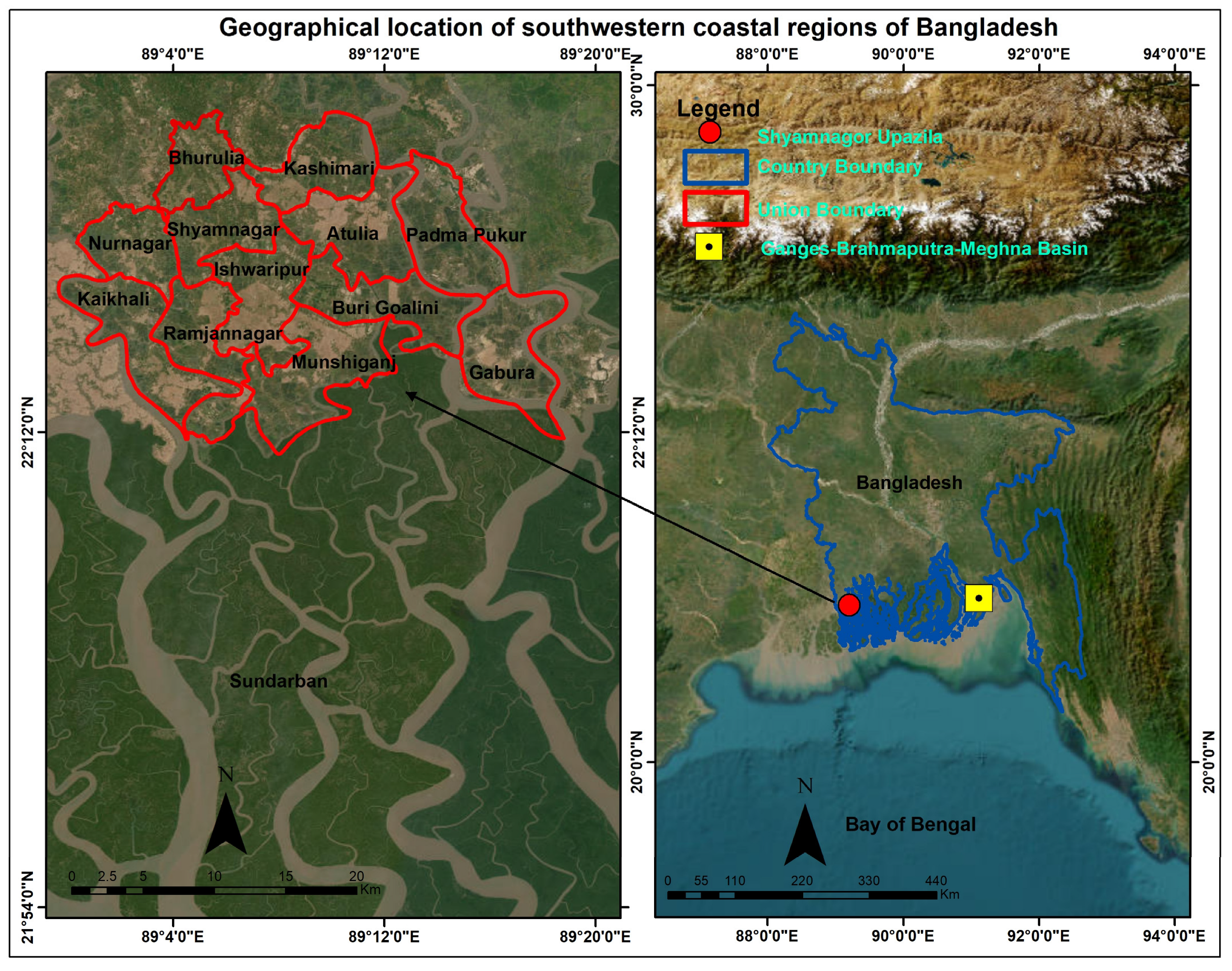
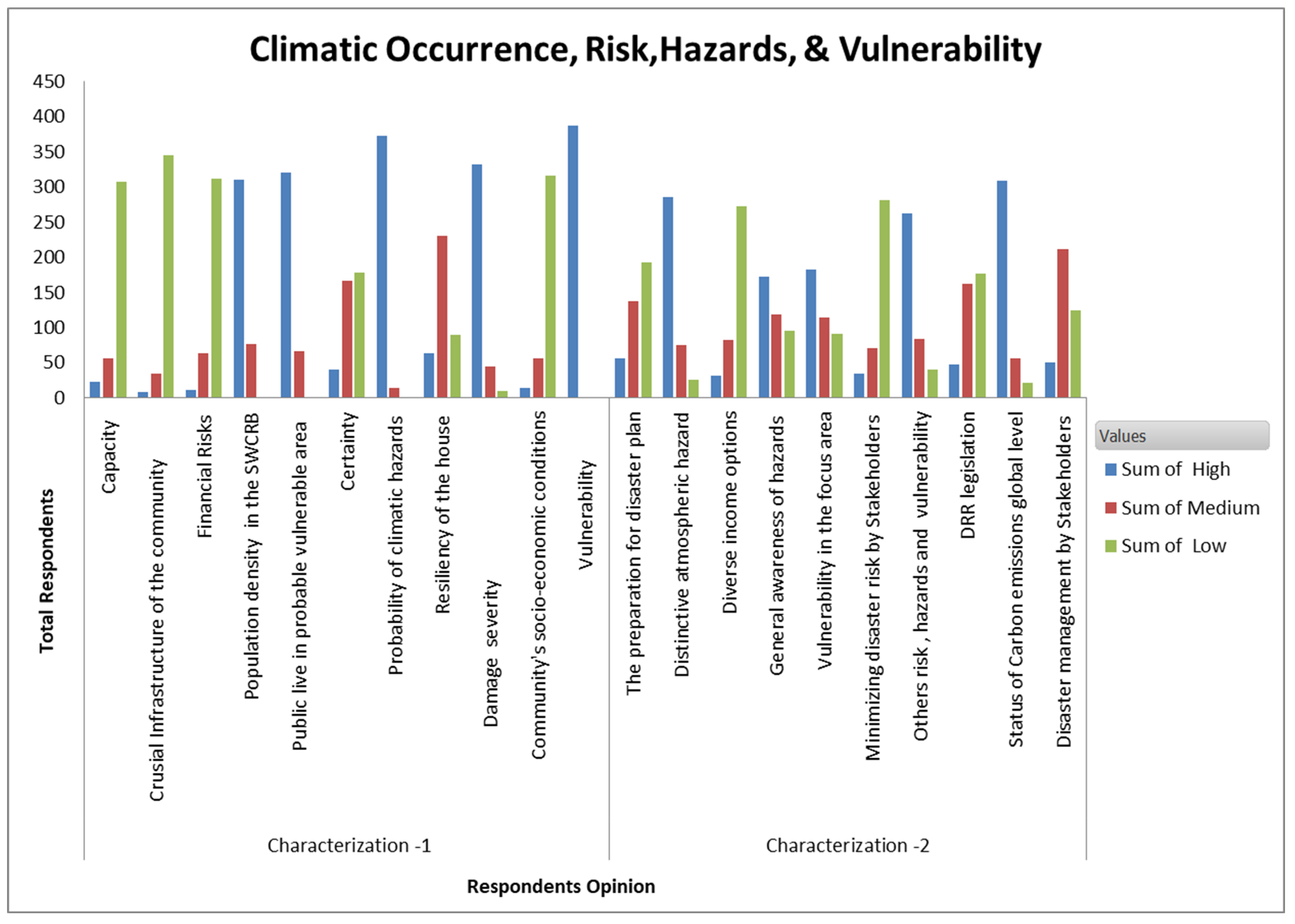
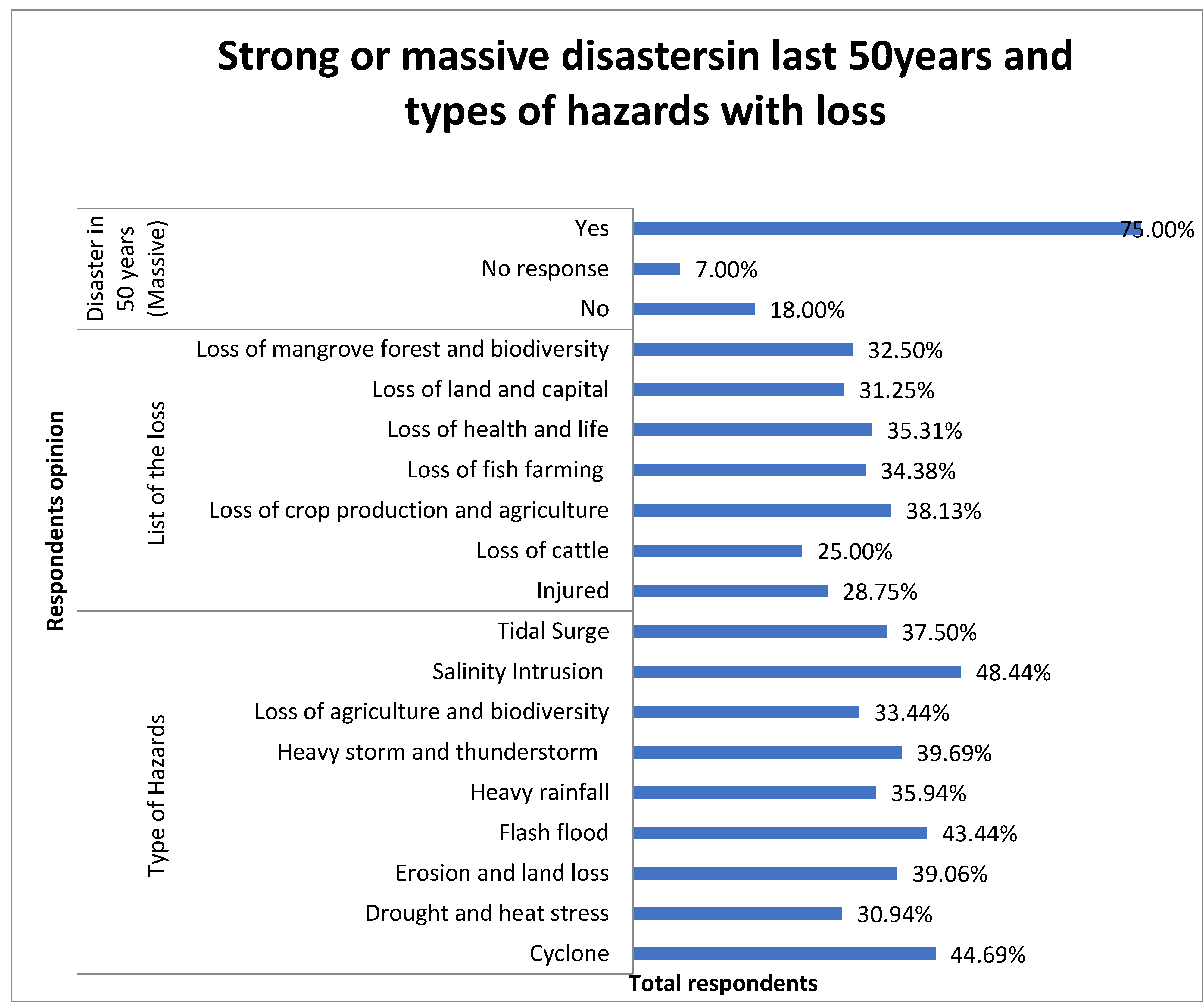
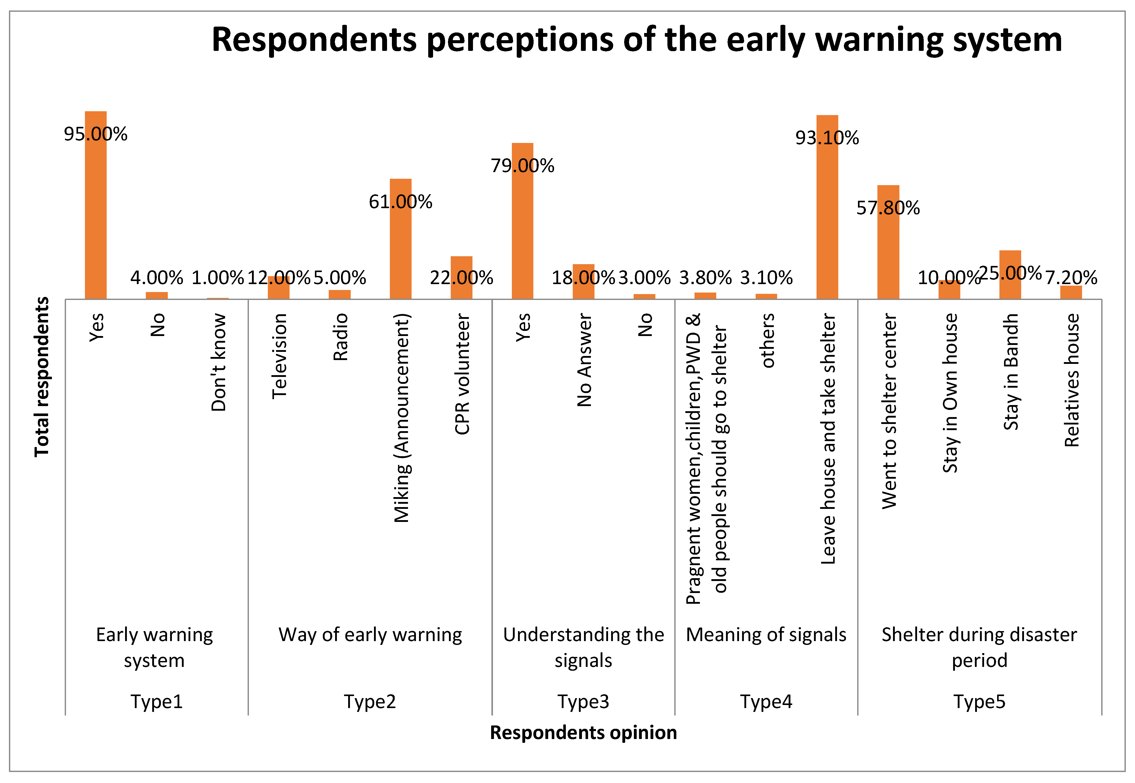
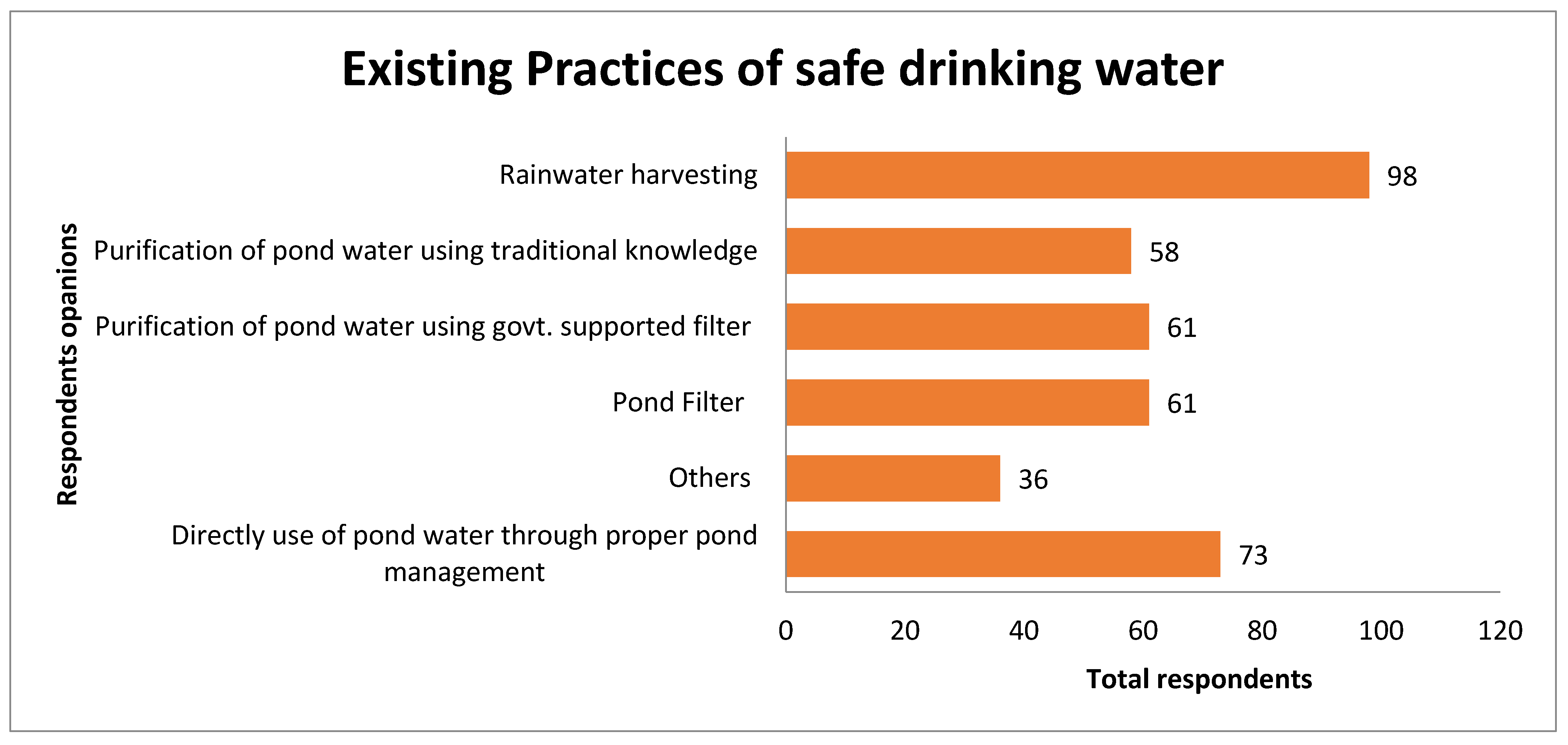
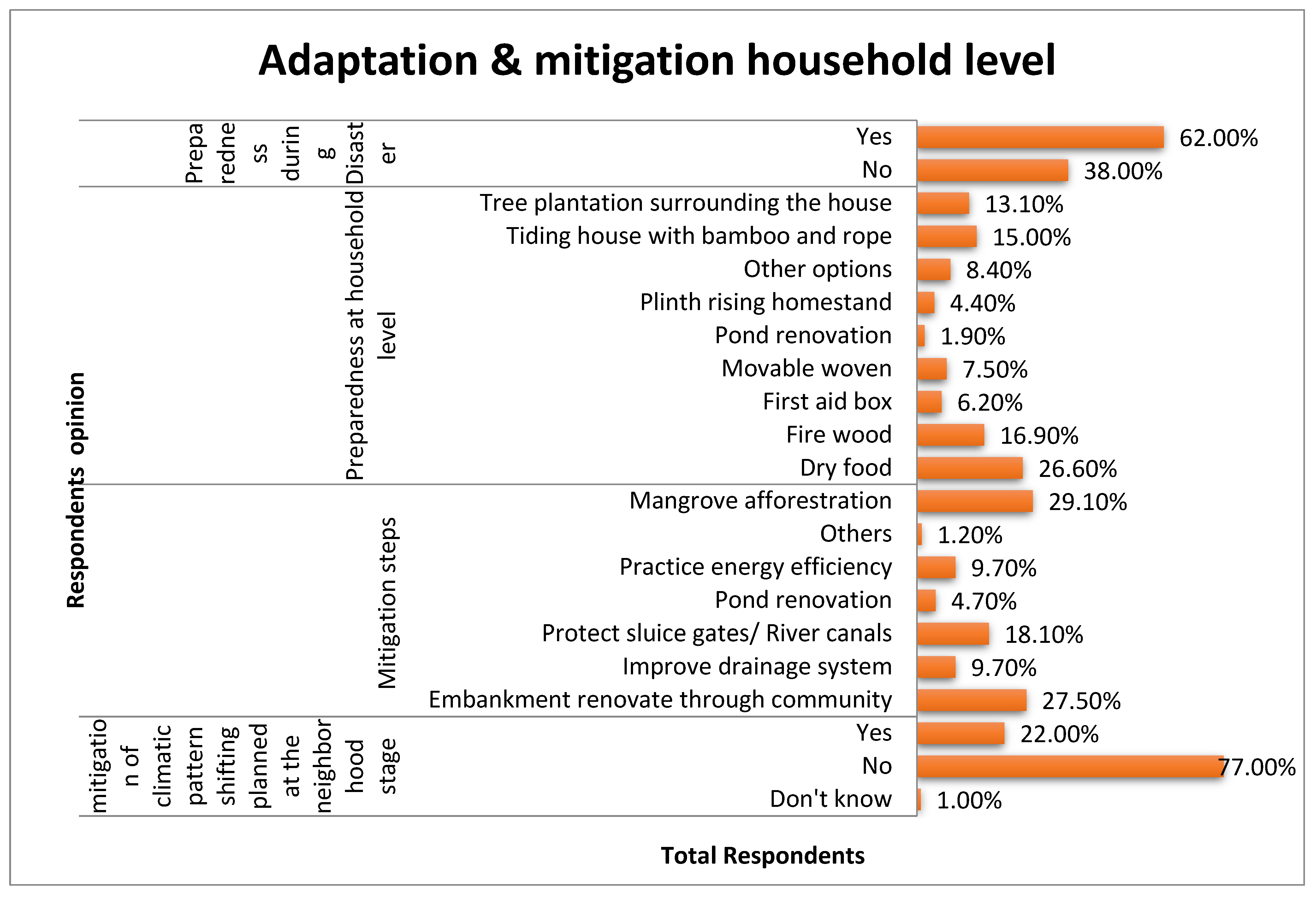
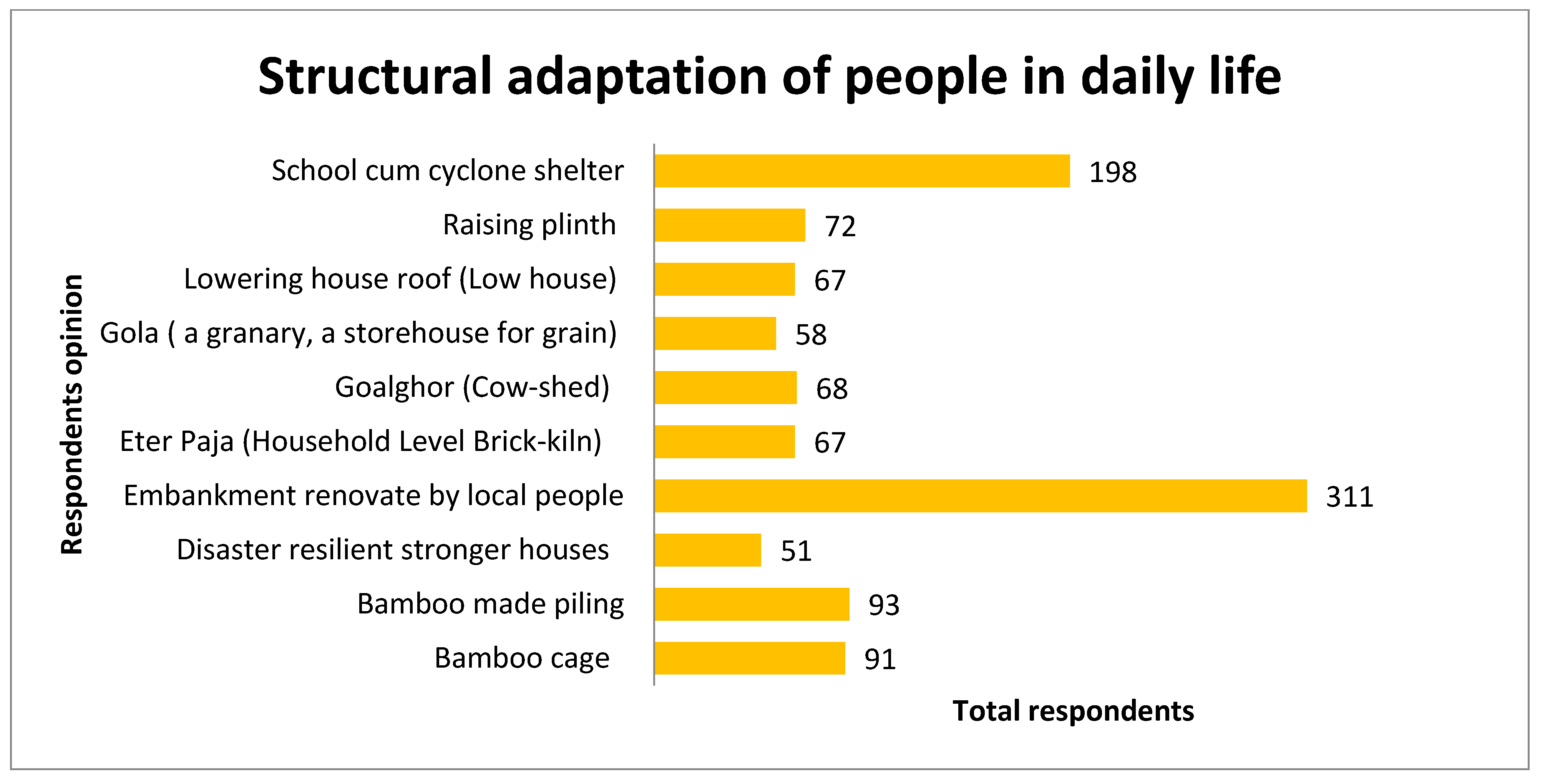
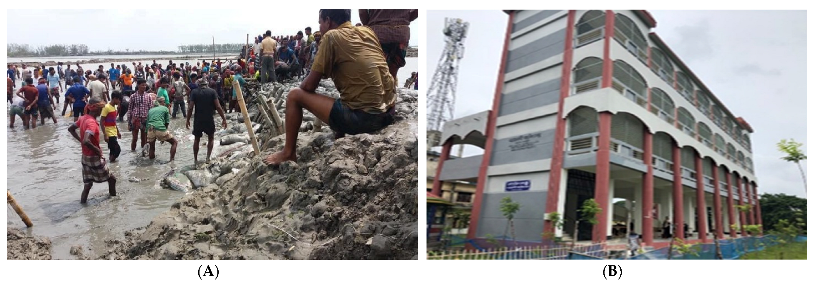
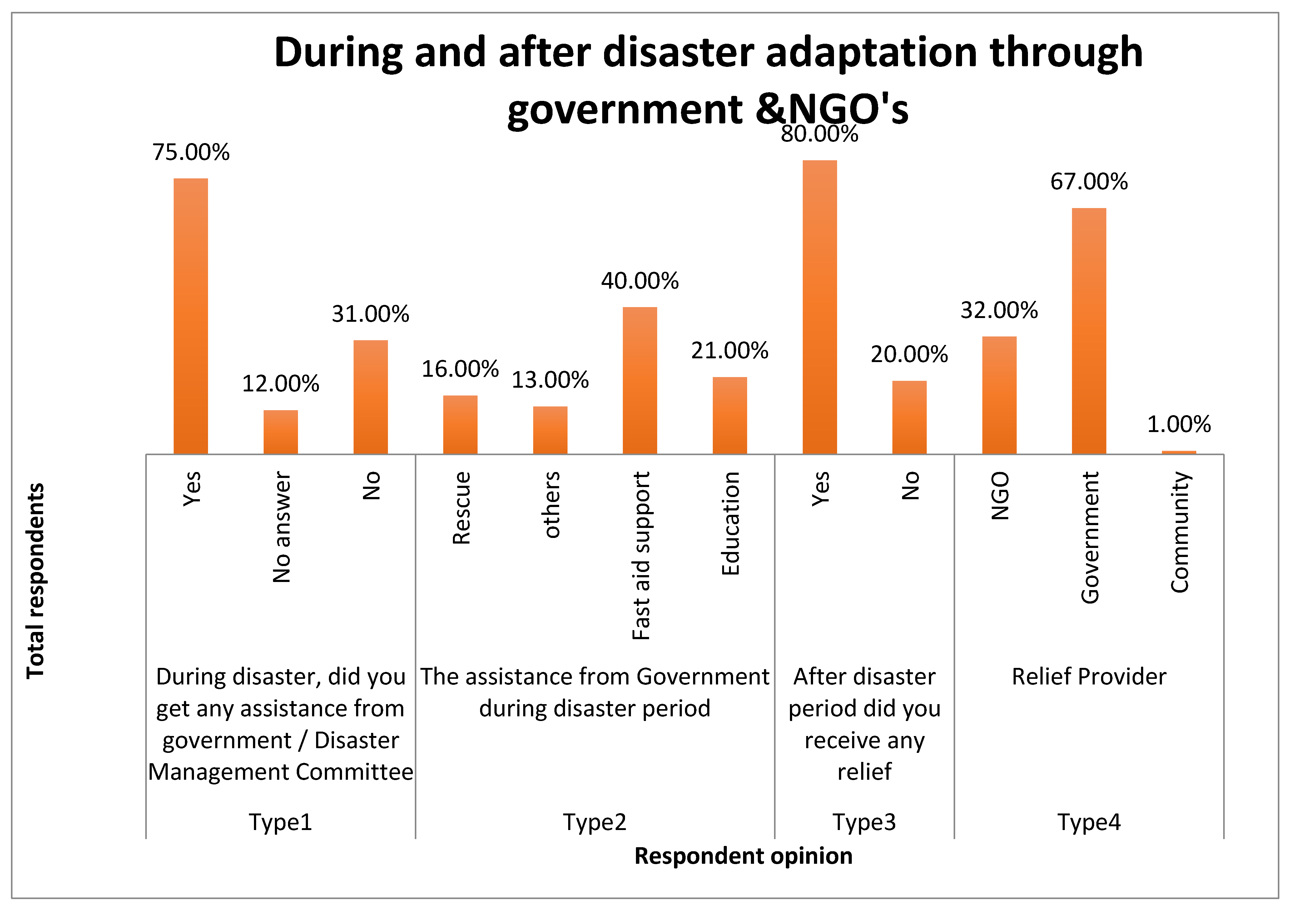
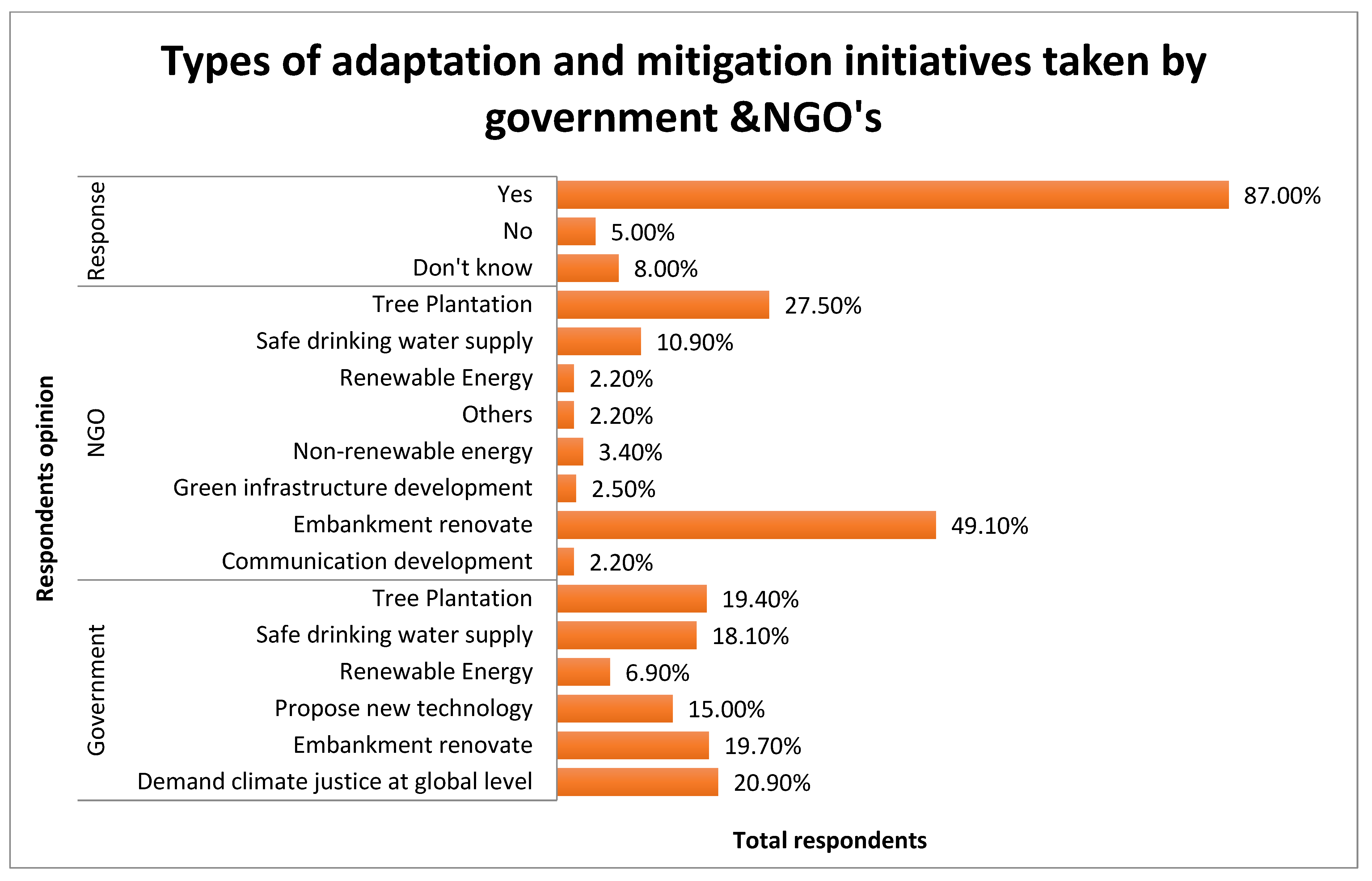
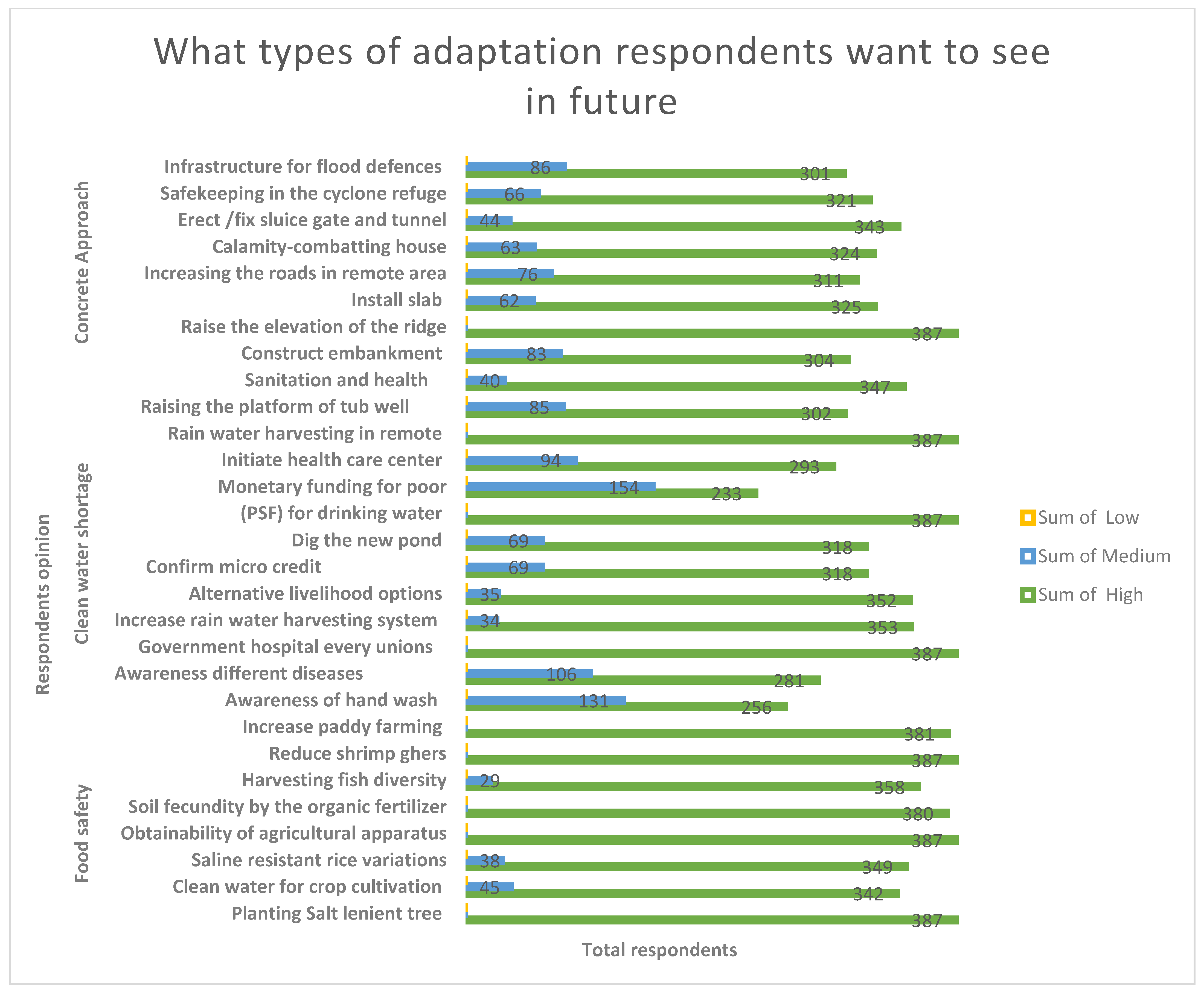
Table 1.
Details of quantitative sample size distribution.
| Type of Respondents | Union Coverage | N | n | Female Numbers | Male Numbers | Percentage of Youth |
|---|---|---|---|---|---|---|
| Risk and hazard analysis | 12 | 318,254 | 387 | 189 | 198 | 35.5% |
| Social vulnerability and adaptation analysis | 09 | 242,392 | 320 | 98 | 222 | 25.5% |
Table 2.
Local adaptation and behavior in reaction to climate change in societies of the SWCRB.
| Adaptation Practice | Narrative | Illustration |
|---|---|---|
| Mobility | Periodic movement or perpetual relocation to evade peril or in quest of better conditions | Seasonal, temporary, and permanent migration |
| Interchange | The movement of material and symbolic goods and services between people | Handover of customary information across generations, e.g., house construction Providing information for land uses, e.g., farmstead gardening and mangrove plantation (UDMC) (WDMC) |
| Allocating | Managing the spread or ingesting of limited or acute assets among the people | Recovery relief from government and NGO |
| Sharing | Spreading or involving of new livelihood options across social clusters | Allocation of new scientific information and expertise, homestead gardening, duck rearing, planting trees, pigeon rearing, and local knowledge concerning climate change adaptation |
| Variation | Diversifying food, earnings production tactics, and specialty to augment living | Modifying agricultural excellence and profession, such as shrimp agriculture, women entrepreneurship, and saline endurable rice |
| Strengthening | Growing the obtainability of assets by increasing their harvest | Individual yields in winter and saline endurable vegetables |
| Novelty | New scheme that arises to deal with a definite necessity | Biofuel for culinary need and renewable energy practice |
| Revival | Systematized reconfiguration of dogmas and performances to decrease strain and generate a more pleasing culture | Utilizing conventional information, association, and skills. Embankment project 1960– 1980, Sorjan method agriculture; National Adaptation Plan of Action (NAPA) and the Bangladesh Climate Change Strategies and Action Plan (BCCSAP) |
(FGD, PRA, Observation and Workshops, 2017–2019).
Table 3.
Adaptive alternatives in relation to adverse situations.
| Adaptive Alternatives | Count * | Percentage of Responses |
|---|---|---|
| Financial management for health care | 50 | 15.6% |
| Alternative adaption through microcredit/loan | 88 | 27.5% |
| Occupational changes | 176 | 55% |
| Migration as an alternative process | 80 | 25% |
| Social networking | 92 | 28.8% |
| Savings | 28 | 8.75% |
| Others | 112 | 35% |
* Multiple responses: N = 320, source: field survey, 2017–2019.
Table 4.
Local adaptation events that are reducing climatic risk as well as exploring climate-resilient livelihoods in vulnerable communities.
Table 4.
Local adaptation events that are reducing climatic risk as well as exploring climate-resilient livelihoods in vulnerable communities.
| Adaptation | Adaptation Segment | Participant Code/Informer Under 12 Unions |
|---|---|---|
| Adapt to salinity | Grass cultivation, cage aquaculture, crab fattening, shrimp-fish mixed cultivation | Participant 33, Participant 34, Participant 35, Participant 36 |
| Adapt to cyclones, storm surges, tides, floods, waterlogging and high salinity, and severe erosion in the rainy season | Keora nursery, mele (reed) cultivation, cattle raising, shrimp-fish mixed cultivation, growing local rice variety (BR 28), goalpata cultivation, Keora cultivation, vegetable cultivation on raised mound with concrete wall, fish and vegetables combined cultivation, eter paja (household level brick-kiln), dyke cropping, hanging vegetables, hydroponics, poultry farming, cropping on raised mound vegetables, homestead gardening, combined cultivation of fish and hanging vegetables, Aman rice and fish (bagda, golda, rui, and katla) combined cultivation | Participant 37, Participant 38, Participant 39, Participant 40, Participant 41, Participant 42, Participant 43, Participant 44, Participant 45, Participant 46, Participant 47, Participant 48, Participant 49, Participant 50, Participant 51 |
| Alternative income generation, innovative income generation | Apiculture—beekeeping and honey, vegetable cultivation on the banks of homestead fish ponds, vegetable cultivation on homestead yards, shrimp cultivation at homestead | Participant 52, Participant 53, Participant 54, Participant 55, Participant 56, Participant 57, Participant 58 |
| Adapt to drought | local rice variety (T-Aus.) | Participant 59, Participant 60, Participant 61, Participant 62, Participant 63, Participant 64 |
| Adapt to the salinity of groundwater and even most surface water bodies | Purification of pond water using govt. supported filter, purification of pond water using traditional knowledge, fainwater harvesting in rectangular concrete tank, fainwater harvesting through hanging canvas while raining, pond filter | Participant 65, Participant 66, Participant 67, Participant 68, Participant 69 |
| Structural adaptation to pests and insects | Gola (a granary, a storehouse for grain) | Participant 70, Participant 71, Participant 72, Participant 73 |
| Structural adaptation to the strong force of cyclone wind and tidal surge, riverbank erosion, coastal flooding, and salinity | School cum cyclone shelter, bamboo-made piling, bamboo cage—to protect riverbanks, raising plinth | Participant 74, Participant 75, Participant 76, Participant 77, Participant 78, Participant 79, Participant 80, Participant 81, Participant 82 |
| Structural adaptation | Lower house roofs for houses with stronger disaster resistance (low house)—lower house roofs as much as possible to avoid the destructive power of strong winds in hurricanes | Participant 83, Participant 84, Participant 85, Participant 86, Participant 87, Participant 88, Participant 89, Participant 90, Participant 91, Participant 92 |
| Structural adaptation | Earth embankment for protection of salt water and embankment built by the local community | Participant 93, Participant 97, Participant 94, Participant 98, Participant 95, Participant 99, Participant 96 |
FGDs, interviews, and workshops (2017–2019).
Disclaimer/Publisher’s Note: The statements, opinions and data contained in all publications are solely those of the individual author(s) and contributor(s) and not of MDPI and/or the editor(s). MDPI and/or the editor(s) disclaim responsibility for any injury to people or property resulting from any ideas, methods, instructions or products referred to in the content. |
© 2023 by the author. Licensee MDPI, Basel, Switzerland. This article is an open access article distributed under the terms and conditions of the Creative Commons Attribution (CC BY) license (https://creativecommons.org/licenses/by/4.0/).
Share and Cite
MDPI and ACS Style
Ashrafuzzaman, M. Local Context of Climate Change Adaptation in the South-Western Coastal Region of Bangladesh. Sustainability 2023, 15, 6664. https://0-doi-org.brum.beds.ac.uk/10.3390/su15086664
AMA Style
Ashrafuzzaman M. Local Context of Climate Change Adaptation in the South-Western Coastal Region of Bangladesh. Sustainability. 2023; 15(8):6664. https://0-doi-org.brum.beds.ac.uk/10.3390/su15086664
Chicago/Turabian StyleAshrafuzzaman, Md. 2023. "Local Context of Climate Change Adaptation in the South-Western Coastal Region of Bangladesh" Sustainability 15, no. 8: 6664. https://0-doi-org.brum.beds.ac.uk/10.3390/su15086664
Note that from the first issue of 2016, this journal uses article numbers instead of page numbers. See further details here.