Case Report

Built Cultural Heritage Recording and Evaluation in the Traditional Settlement of Siatista in Greece: Functional and Institutional Proposals for Conservation

School of Architecture, National Technical University of Athens, 10682 Athens, Greece
Submission received: 16 June 2019 / Revised: 16 August 2019 / Accepted: 19 August 2019 / Published: 26 August 2019
(This article belongs to the Special Issue Nature & Culture for Cities and Territories)

Abstract

:
This case report explores the town of Siatista (located in the Western Macedonia Region—Greece), which is designated as a “traditional settlement”. The paper argues that, despite the relevant legislation that designated 400 settlements in Greece as “traditional settlements” and put them under protection, Siatista has no delimited traditional section. Through the years, new house typologies, demolitions, and alterations of its urban form have appeared, and Siatista has lost its identity. Having as an ultimate goal to identify proper planning guidelines and regulations for the preservation of Siatista’s built heritage, the methodology used in the paper includes the following steps: (a) recording and codification of the key legislation for the protection of Siatista, including the official urban plans (and their revisions); (b) identification and mapping of the urban form and spatial characteristics of Siatista (existing land uses, house typology, etc.); (c) identification of the alterations of the urban form and the demolitions, mainly with the use of aerial photos (1960–2014); and (d) creation of a map presenting the remaining built heritage per degree of evaluation. Following the analysis of the existing situation and the identification of the key challenges, the paper ends by defining and delimitating the well-preserved section of the town (proposing stricter rules and regulations for its preservation).

1. Introduction

In the 1970s, Greece, under the supervision of the Greek Ministry of Environment and Regional Planning, began a program entitled “Recognition of Architectural Physiognomy” at the level of the prefectures of Greece. The program tried to record the architectural forms and the physiognomy of settlements, mainly the small ones with less than 2000 inhabitants, but also of the most significant ones, in order to find and define conditions and building restrictions for them. After this program, 1232 settlements around Greece were characterized as “remarkable settlements.” Following a Presidential Decree in 1978, 400 of them, the most significant ones and those most representative of the traditional architecture, were designated as “traditional settlements” [1]. In this paper, the term “physiognomy” refers to the unique characteristics of a place, without comparison to other places [2]. Siatista is one of the 400 traditional settlements. The main problem of this effort is that those records were made mainly by architectural offices spread all over Greece, resulting in qualitative differences between different prefectures [3,4,5,6]. This led to a failed result, as no common criteria and specifications were identified. However, they are still used as a source of record of traditional settlements and a point of reference for (a) the attempt to record the physiognomy and (b) the effort to put some criteria and morphological rules and regulations. This case report deals with that problems in the settlement of Siatista Voios Kozani.
Siatista is located in Greece, in the region of Western Macedonia, at the municipality of Voios Kozani, and is a settlement surrounded by mountains. Voios Kozani is one of the four municipalities of the Regional Unit of Kozani, and Siatista is the administrative capital of the Municipality of Voios. Voios has a long history of intangible and tangible cultural heritage, with a rich historical and architectural past [7]. The development of these areas, due to the merchants traveling in Europe, directly affects urban and architectural design, with those settlements declared as “traditional” according to the 1978 decree. In total, Voios includes three traditional settlements (Siatista, Pentalofos, and Vlasti). This work will focus on Siatista Voios Kozani utilizing the author’s 10 years of research on the settlement at the urban and architectural level [8].
This paper, concerning the urban level of planning, is a proposal for a built heritage protection zone and new rules and regulations for its preservation. Siatista was designated as “traditional settlement” in 1978 (Presidential Decree 594), along with 400 other settlements in Greece. It has a fortified structure with narrow streets, stone fences, etc. [9]. The settlement was founded in the 15th century [9] by refugees from the surrounding areas who migrated into the settlement. Over the years, the population of the settlement changed through the internal and external migrations of its inhabitants. After the 17th century, Siatista’s development reached its peak, driven by exports of fur (the population’s main occupation) and trade with other European countries [10]. The travel undertaken by Siatista’s inhabitants was reflected on its built heritage and residence types, such as the types of houses called “mansions” that are two-story buildings with great interior wooden and stone structures and wall drawings. The main occupation of the inhabitants, up to the 19th century, was the export of fur to other regions in Europe and the Balkans. Today, fur is hit by the economic crisis and is gradually fading away, with its demise starting after the Industrial Revolution [11]. Over the years, the economic, social, and political conditions have affected the form and urban planning of Siatista and in many cases, have destroyed part of its built heritage, as detailed below. The biggest problem of the 1978 designation was that the decree only named the characterized settlements as “traditional” without delimiting a “traditional” or a “built heritage protection zone” in the well-preserved sections. This decision has created many problems through the years, such as demolitions, alterations, etc.
Another issue contributing to the loss of the traditional core and the distortion of the physiognomy and architecture of Siatista is the construction of new types of houses, called “polykatoikies,” before Siatista’s declaration as a “traditional settlement”. Additionally, no effort to properly delimit the meaning of “traditional” has been made in every new protection decree since 1978. These problems have created legal loopholes and a great deal of arbitrariness. For this reason, and mainly due to the lack of bibliographic references, this paper proceeds, first, to make use of poor bibliographic references and then field research. The results of this case report show that the settlement has undergone alterations and reconstructions over the years. The aim of this case report is to identify the remaining built heritage and well-preserved section of the settlement and propose a delimitation of its original core as “traditional” and a new set of rules and regulations for its preservation. In the future, these new rules and regulations can contribute to the creation of the urban planning of Siatista and especially to the new town planning.

2. Materials and Methods

2.1. Methodology

The main goal of this case report is to identify the remaining cultural heritage and well-preserved sections of the cultural heritage of the traditional settlement of Siatista Voios Kozani. This goal, first, tries to recognize the reasons that have caused the loss of a large amount of Siatista’s heritage over the years. Second, the aim of the case report is to solve the problem of the non-delimitation of the traditional section of the settlement after Siatista was declared a “traditional settlement” in 1978. Finally, the case report proposes the limitation of the “traditional” designation to the well-preserved section of the built heritage of Siatista and a new legal framework of rules and regulations aimed at preserving the remaining heritage, culture, types and morphology of old and new buildings, and the listed buildings of the settlement. The methodology is separated in bibliographic and field research due to the lack of literature. In Siatista, four types of buildings are identified as mentioned below, but only one of them (mansions) has bibliographic references. Additionally, mapping research and recording of the built and architecture heritage has not been made in the last 20 years. So, field research was necessary in order to strengthen the knowledge base of the research. The case report has two main chapters, the literature/field research and the proposal of delimitation and new rules and regulations. In the first chapter, as a result of the literature research, the morphology of the buildings is presented, as well as the urban planning and the type of buildings. This is an introductory chapter on the general recognition of the settlement and the presentation the relevant literature, through its heritage and its long history. It also presents the alterations and demolitions the new buildings etc. Following this, all the legislative texts are gathered in a chronological order as a mean to detect the period of the demolitions, the loss of Siatista’s cultural heritage, as well as the problem of the non-definition of the limits of the traditional settlement.
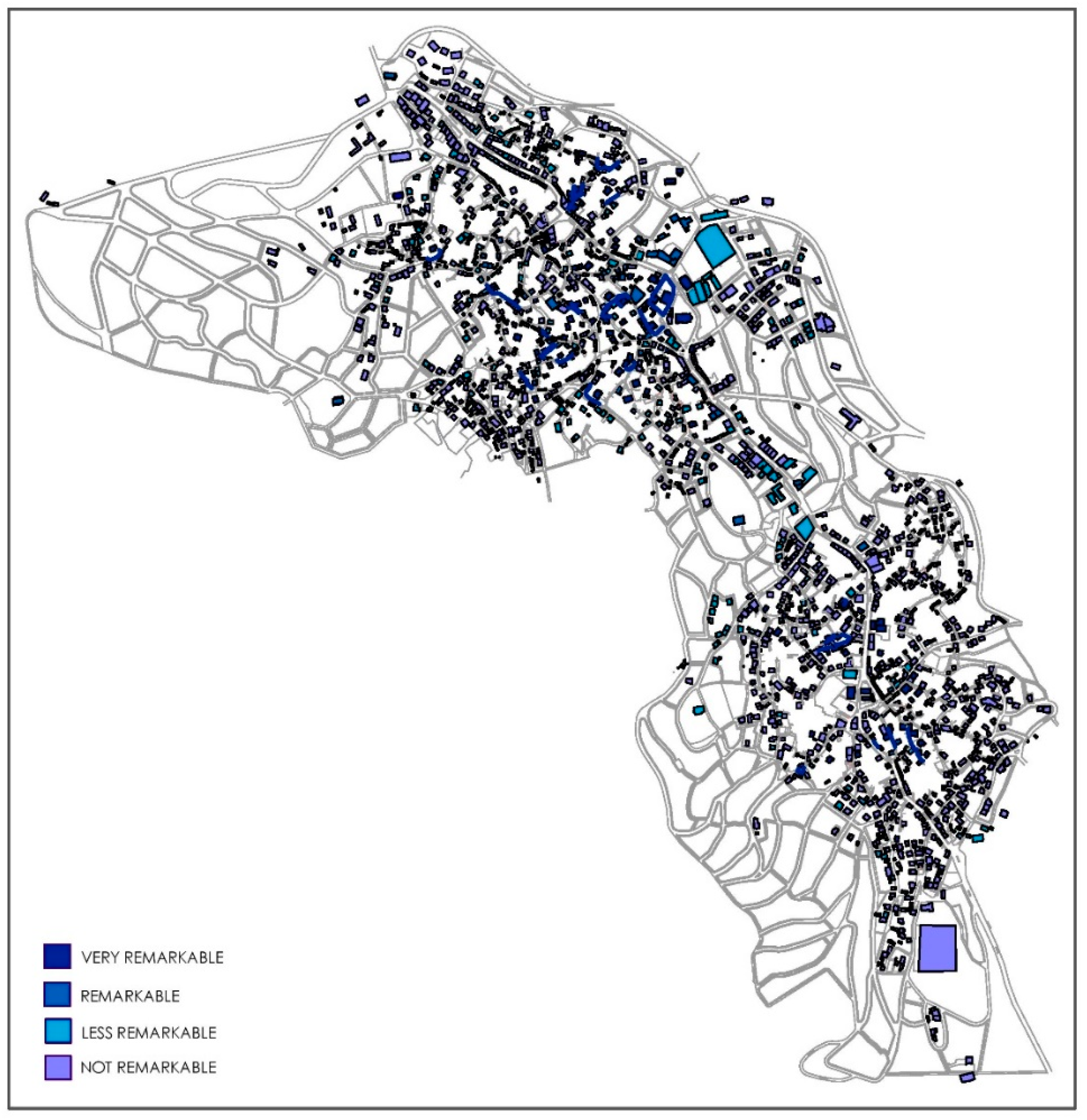
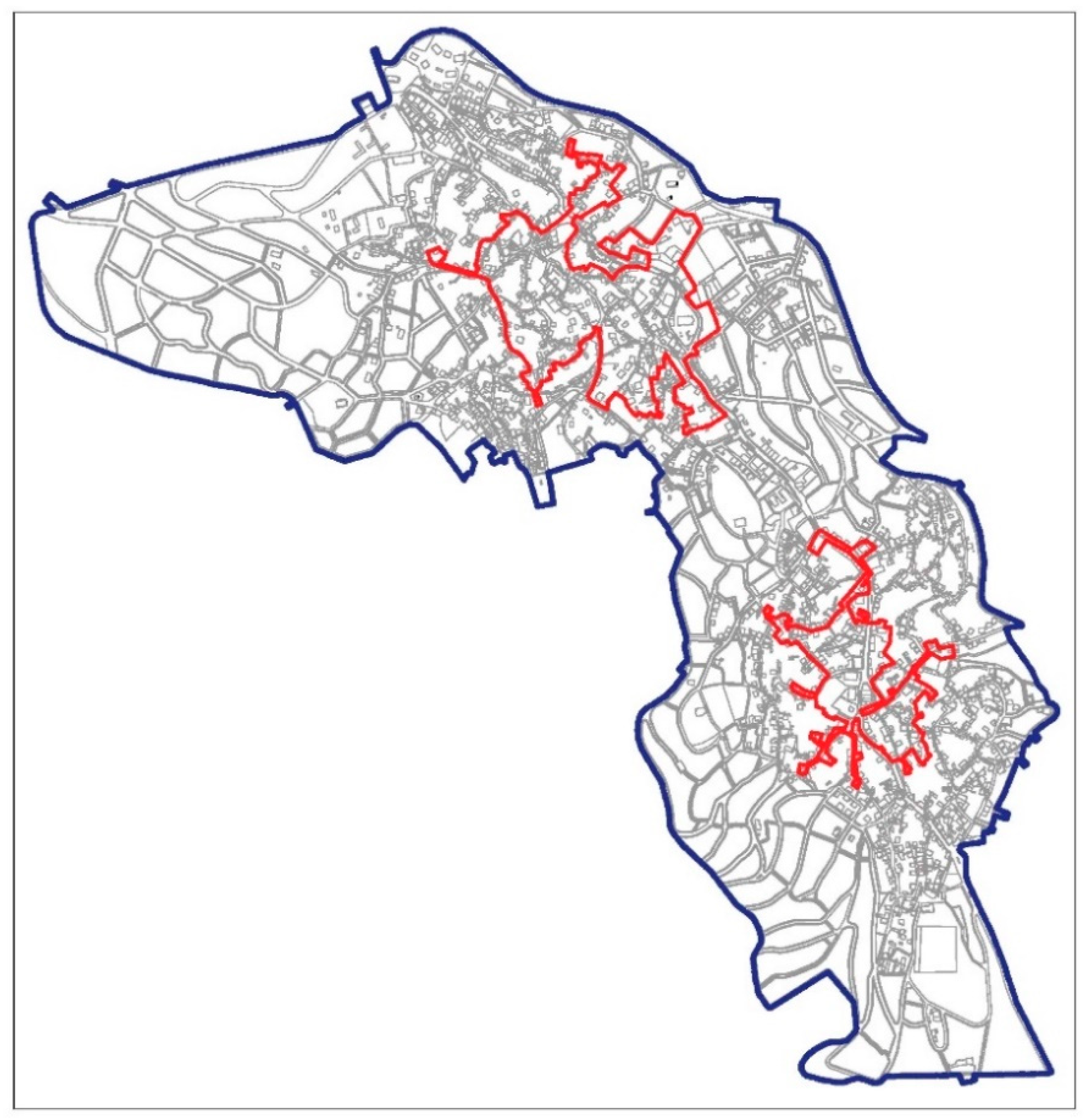
This chapter is an attempt, through the detailed reading and interpretation of the legislative texts, to identify the point of interruption that caused this loss and also to look for the reasons and the legislative failures and shortcomings that contributed to it. Due to the lack of literature, and in order to triangulate the data/results of the literature research and confirm the conclusions of the legislative texts, two funds have been created, one concerning the certification of the above, through timely aerial photos of the settlement and quantitative data (period of construction of buildings) and a cartographic research chapter with mapping of the whole area of the settlement (land use and typology of buildings maps). In the end of this chapter is the proposal of the delimitation and the new rules and regulations. Before the proposal and as a result of the literature, the field research and the mapping of the settlement an evaluation map was created in order to evaluate the remaining cultural heritage of Siatista. This map is the first step and the findings of these (the remaining cultural assets) lead to the proposal of the new delimitation of the well-preserved section in order to preserve and protect the remaining cultural heritage. Consequently, a decree of new rules and regulations is proposed according to Siatista’s physiognomy.

2.2. Description and Evolution of the Built Heritage of Siatista

Siatista, since its creation, has two districts, Chora and Gerania, with the latter showing habitation first in Gerania, without being fully confirmed [9]. Geomorphologically, Siatista consists of slopes and perimetric mountains with its original construction distinguished by the mansions, the large courtyards, narrow streets, and stone fences [10]. During the 17th century, Siatista went through intense urban and residential development, based on the construction of mansions, which are residences of the merchants. The merchants travel in Europe and embed in the design of their residences elements such as interior designs and architectural forms [
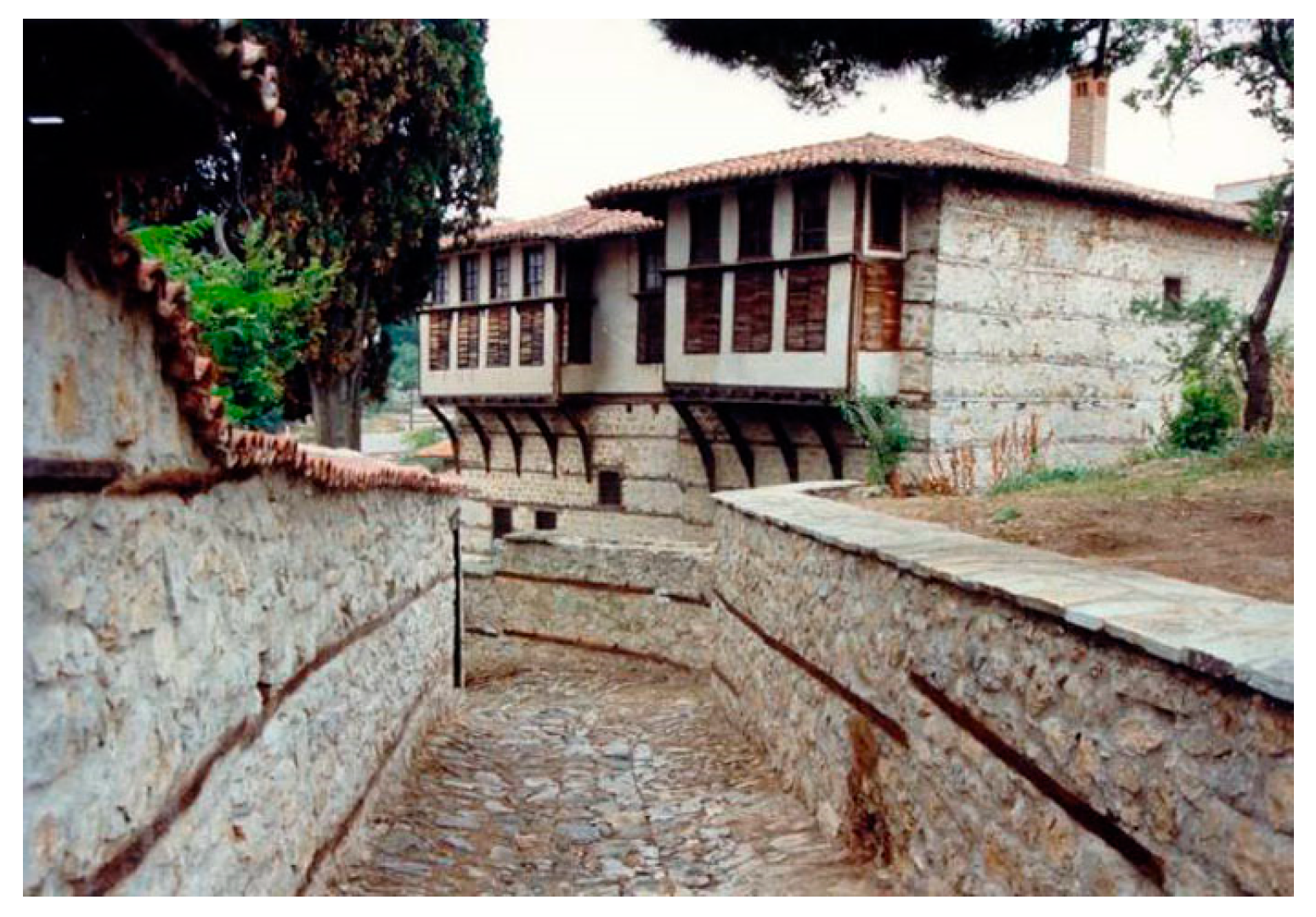
11]. The mansions are built in top view, P- or C- shaped, and the structure follows a form of two floors. The ground floor is built with stone and the second floor is made of waddle and daub to lighten the weight of the construction. In the second floor, two closed balconies called ‘sahnishia’ (one left and one right) are created (see Figure 1). The balcony is prominently in the front façade, 0.4–0.6 m, and is based on wooden projections. In the left façade, a small cabin has been used as a toilet from the 1950s onwards.
Internally, in the ground floor, a hall with stone tiles is in the entrance of the mansion and around this, on the left is the fur shop and centrally the storage areas for the auxiliary uses (such as storage of food and wine). On the right, a stone staircase leads to the first floor, to the ‘winter rooms’, as they are called. In the left part of the entrance, another staircase (half stone–made and half wooden-made), leads to the second floor, i.e. the ‘summer rooms’. On the second floor, there is the main area of the guests, named ‘solar’ or ‘dullian’ and around it, the rooms (bedroom, kitchen, etc.) are created. The interior decoration is complemented by medallions (wooden wardrobes), wooden ceilings (see Figure 2a), floors and windows and doors, as well as rich painting (frescos and paintings in the wooden wardrobes), wood-carved decoration and fireplaces with decorations (see Figure 2b) [12,13]. The wooden windows and doors are rectangular with table-shaped with ironmongers, for protection reasons.
In Siatista, despite the introversion of the large mansions, the stone fence and the internal courtyard organization with auxiliary uses, there are also narrow and cobbled streets [12]. The authentic stone fences and the adjoining courtyard buildings have been replaced with smaller stone fences or have been completely demolished, with only few of them are remaining [13]. On the perimeter of the mansions, there were the “musafirika”, the residences of the visitors, who live outside the mansion and the “outhouses”, the residences of the mansion’s servants [
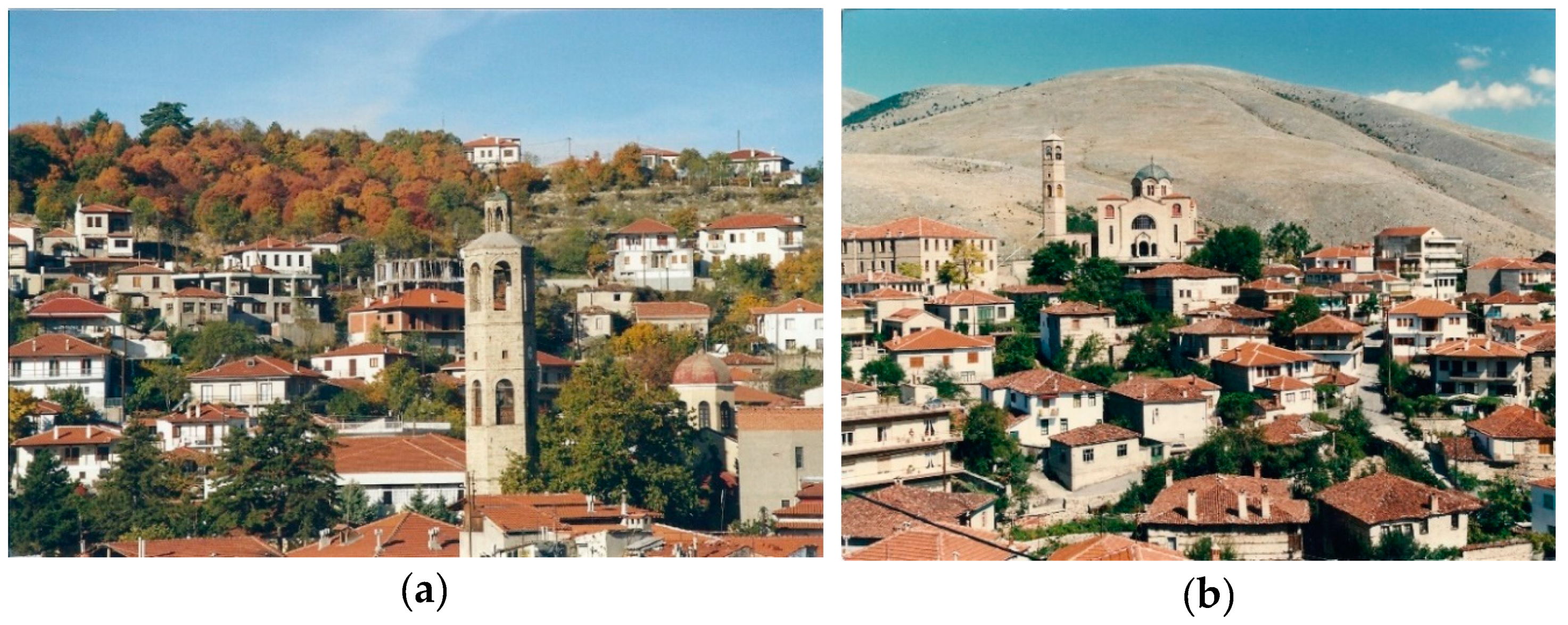
14]. Today, the field research shows that only few of them remain and the old mansions are abandoned and in a very bad condition. The landscape of the settlement is completed with 22 churches (see Figure 3) and chapels in and around it [15]. There are also three elementary school buildings, a high school, a music school, a health center, a town hall, a library and many other buildings, all donations of benefactors.
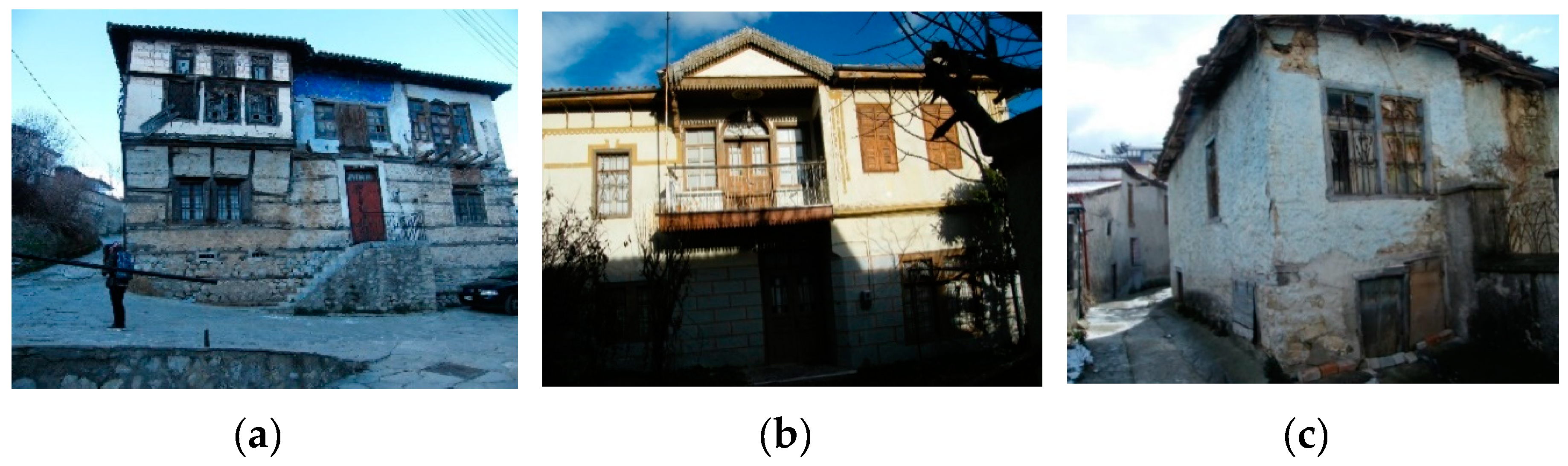
Beyond the listed mansions [16], the built heritage of the settlement is completed by the two older types of buildings, which are “the typical examples of traditional architecture” and the “rural buildings” [8]. According to the “Permanent catalog of listed monuments and archaeological sites of Greece” [17], 19 mansions (see Figure 4a) and 34 typical examples of traditional architecture (see Figure 4b) are protected individually without their surrounding area. Interestingly, until the Decree of 1978, eleven of the declared mansions have already been protected gradually but afterwards, no efforts were made in order to collect, record and protect the rest of the cultural heritage. This gradually led to significant damage and loss of important mansions, incompatible restorations, and many demolitions of accompanied buildings such as wells, ovens, musafirikia, etc. This caused a great loss and a rapid new growth of the settlement, with new types of buildings (polykatoikies) and further alterations and demolitions through the years.
The third type of oldest buildings of Siatista detected by field research is the rural buildings. Rural buildings are simplified examples of mansions made of stone and wood that have not been studied in the literature. Those houses were used by the poorest citizens and nowadays are mainly empty and in poor condition (see Figure 4c).
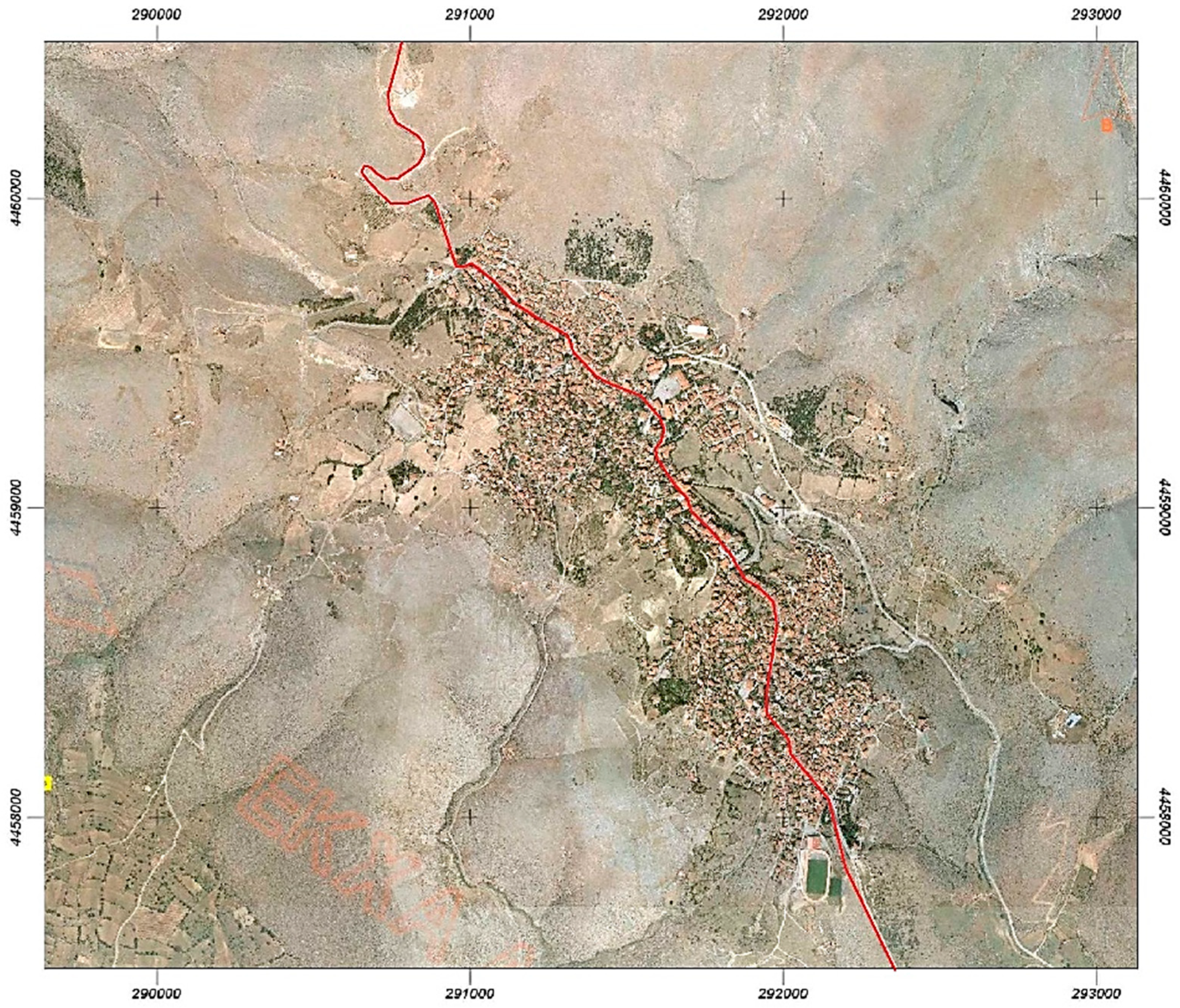
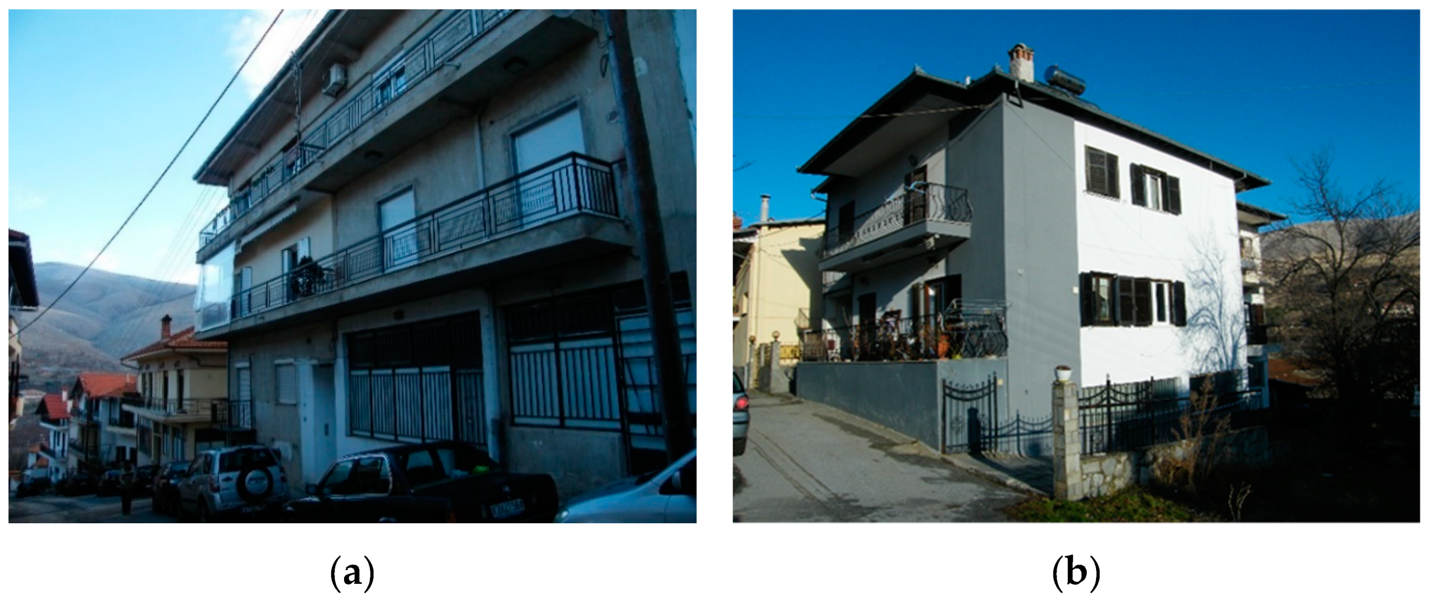
Over time, the proportion of built and unbuilt parts of the settlement changed and the settlement was rapidly filled with new buildings. The new local planning in the 1990s, which favored the alterations and demolitions of the old buildings and the design and structure of a new road in the 1970s (see Figure 5) running through the settlement from the entrance of the town to its exit, influenced not only the local planning, but also the architecture, with new type of roadside residences. These have many floors (called “polykatoikia) and are fully built on land (see Figure 6a) [18]. Those residences were built before the decree of 1978, without any morphological rules and were detrimental to the physiognomy, the identity and the heritage of Siatista. In addition, this road infrastructure collapsed and destroyed several cobbled streets, original stone fences, and mansions.
This caused a significant loss of the built heritage of Siatista. To date, after the morphological and architectural rules of the 1978 decree, the new residences, comply with new morphological regulations that follow traditional forms (see Figure 6b). Those residences are located mainly in the perimeter of the settlement. The main problem is that without the “built-heritage” limit and new strict morphological rules, the main core of the built heritage of the settlement was still under the favor and strategy options of each local authority.
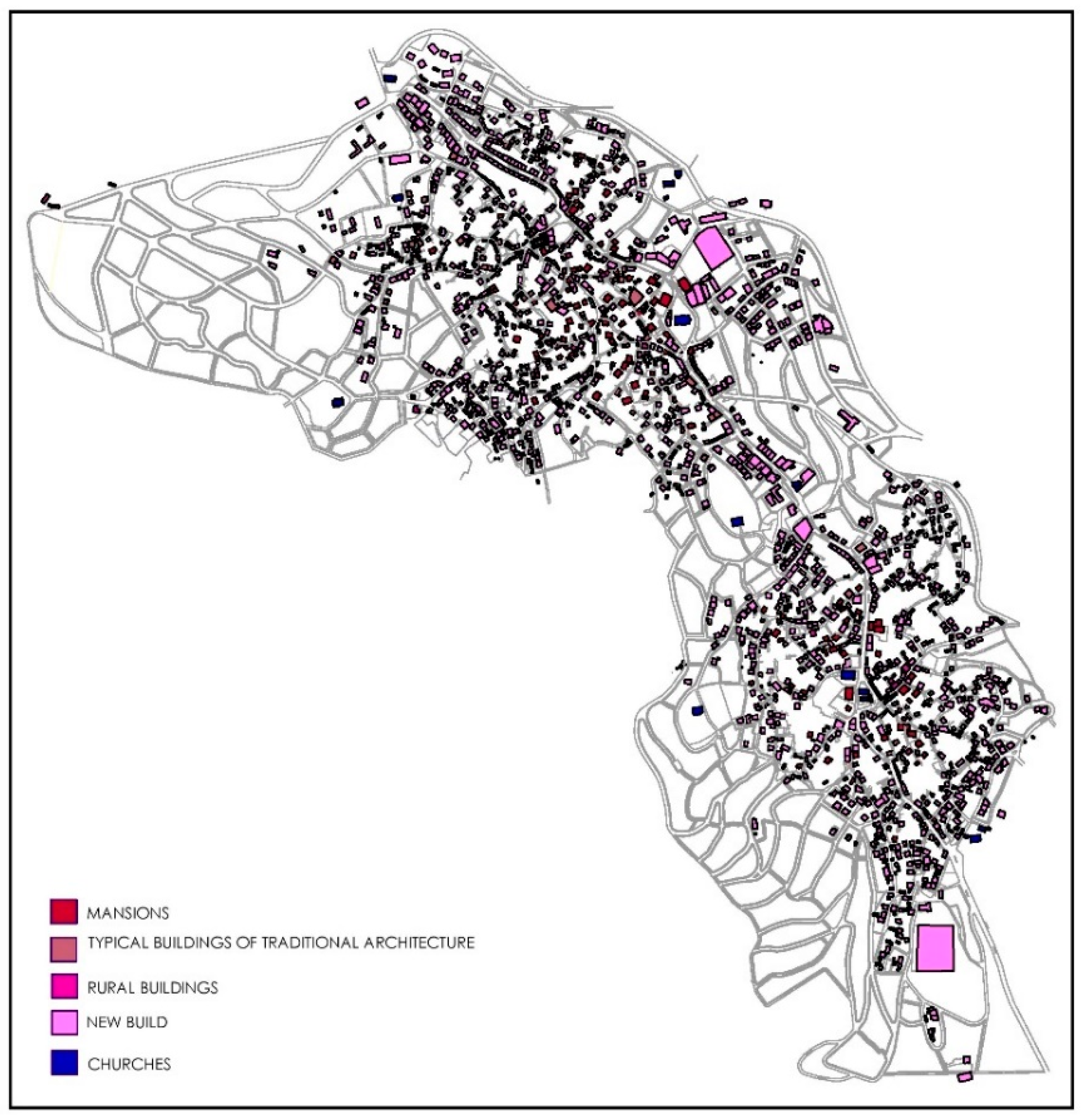
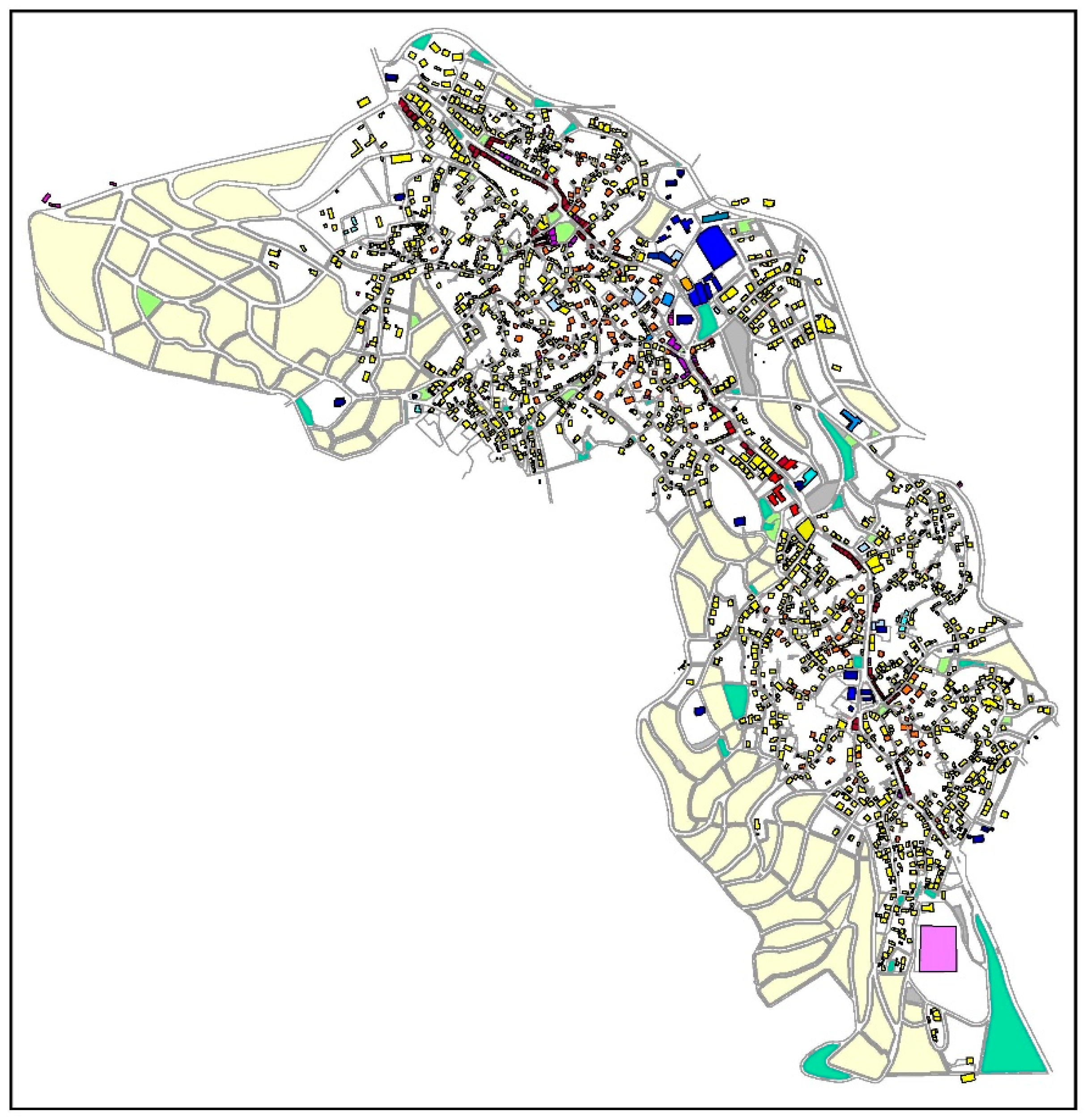
In order to evaluate the settlement of Siatista and propose a new limit of the well-preserved section of Siatista, we conducted a thorough mapping of the whole settlement. After the lack of bibliographic references, field research was required. Also, the aim was to record and protect the remaining cultural heritage of Siatista. The first map that was created was a map illustrating the types of buildings in the area(see Figure 7). Residential is the main land use, expressed in the four types of buildings and elaborated above. The record of those buildings can provide answers for the remaining culture. In the map below (see Figure 7), we identify only two main cores with traditional buildings (mansions, rural and typical examples of traditional architecture). The settlement is filled with new buildings after or before the Presidential Decree of 1978, and all the other three types are fragmented and scattered. The new areas, on the edges of Siatista are newly built areas.

2.3. Planning Law

This chapter presents the legal framework for the protection of the traditional settlement of Siatista in chronological order, aiming at identifying the deficiencies and problems of these legal frameworks. The decrees described in Table 1 and then analyzed separated into three columns under their chronological order of publication [18].
According to the Presidential Decree of 1978, Siatista is characterized as a ‘traditional settlement’ without a delimited built heritage protection zone. The key problem of this decree is that it sets regulations and rules, such as coverage and building factors, by separating the settlement into a central and a remaining part, ignoring the possibility of a non-delimited traditional settlement, as in the case of Siatista. This created misunderstandings and allowed the arbitrary classification in central or non-central part of the settlement. In 1981, a new attempt to define targeted rules and regulations for Siatista was made through the adoption of a presidential decree. The settlement, according to the decree, will be divided into three areas, A, B, C, but these areas cannot be identified in the attached map of the decree. An important point of the decree is the deviations included of Article 5, allowed the demolition of old or “by declare” dangerous buildings. This deviation allowed the restoration of the old buildings, without any morphological rules or the building of totally new houses in old plots of land. So, the old ones were completely demolished or altered. This is the key point of loss of Siatista’s cultural and built heritage.
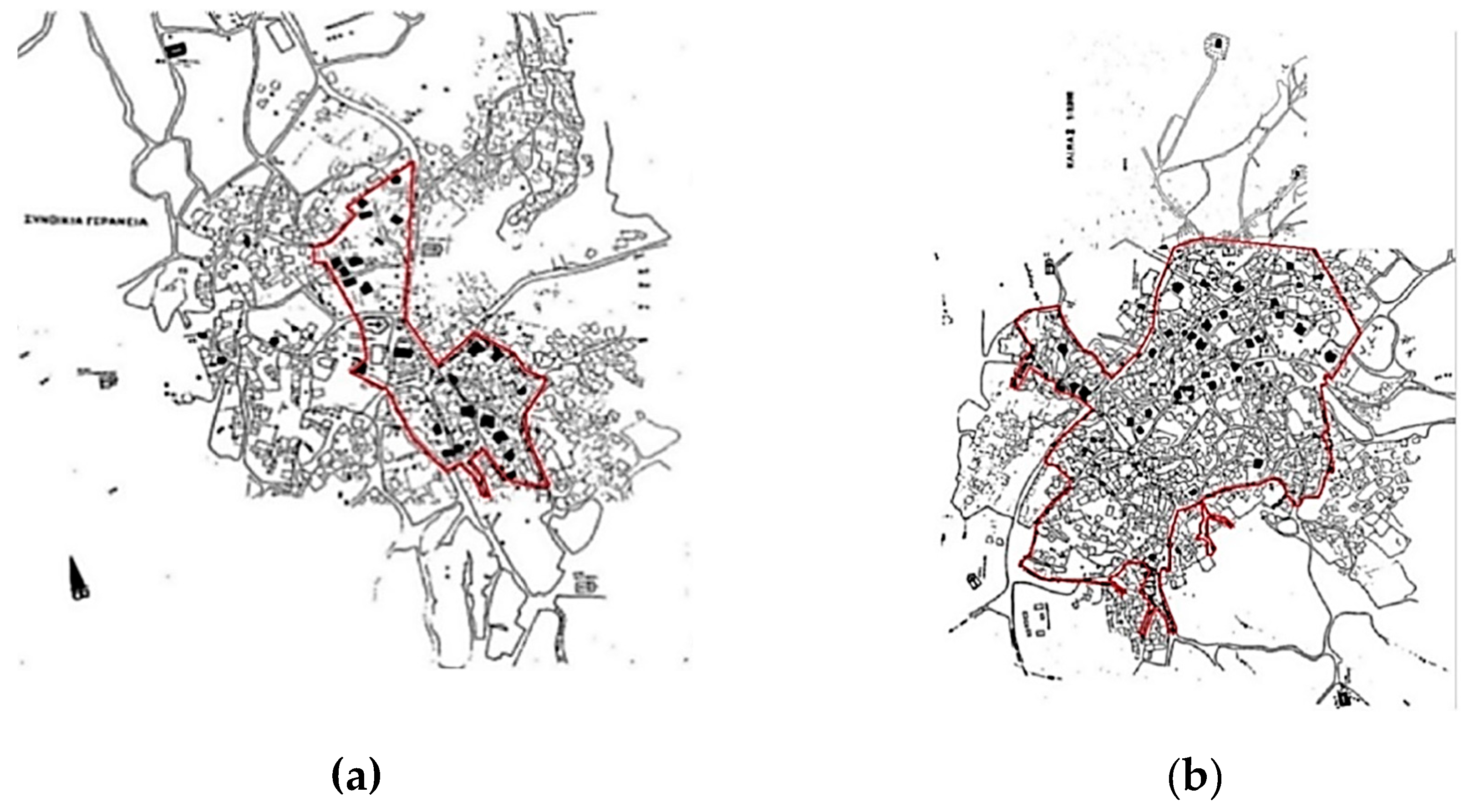
In 1984, with the Ministerial Decree of the Ministry of Culture, the two main neighborhoods of Siatista, name “Chora” and “Gerania” are characterized as “historic sites” (see Figure 8) and several remarkable individual buildings were designated. This decree did not have the goal of new building rules, but proposed two delimited areas for conservation in an effort to protect the remaining heritage. The limits of the historic sites are seem to be by chance, as they do not follow the outline of listed or remarkable buildings.
The urban planning of Siatista was approved in 1996, dividing again the settlement into areas that refer to fragmentary random plot of land, without delimitation. Finally, in 1999, the designation of the densely built part of the settlement was made by the Ministry of Macedonia—Thrace. The demarcation is fragmentary and arbitrary, without including densely built areas, as field research proves. The settlement has already undergone several changes to its original core. Since then, any effort to protect Siatista’s built heritage was not successful.

2.4. Detection Methods: Aerial Photos, Autopsy and Mapping

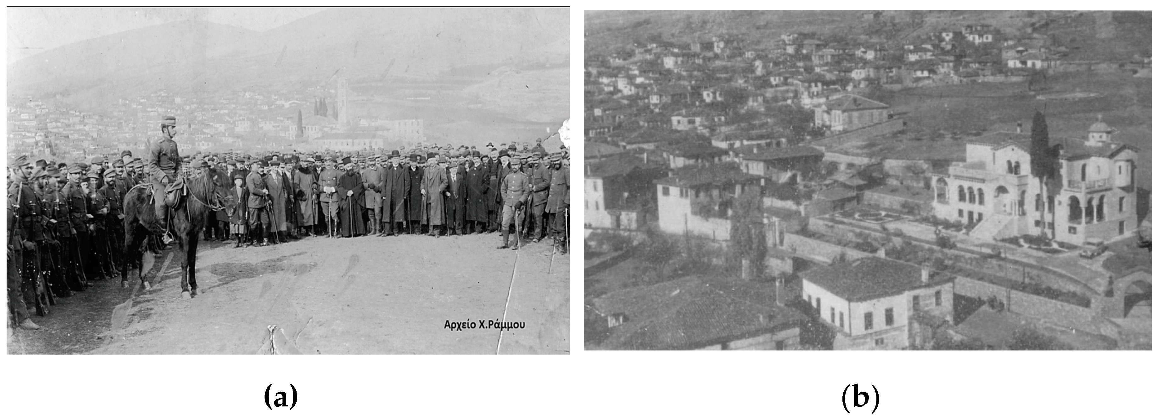
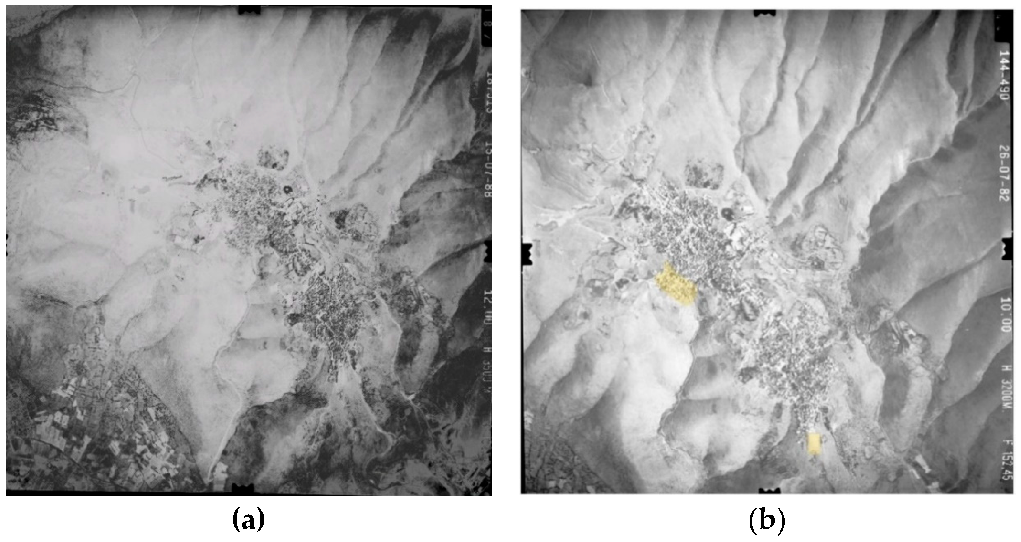
The purpose of this chapter is to triangulate through Army aerial photographs (1969–2008) and old photographs of the settlement as findings of the bibliographic research. The oldest photograph of Siatista from 1912 (see Figure 9a) reveals the two original districts Chora and Gerania, without the present extension to the perimeter of the settlement. The second photo of 1967 (see Figure 9b) shows the new road built in the 1970s and older mansions before the construction of the new buildings and the demolitions through the 1981 Decree.
Following this, aerial photographs are presented. In the original aerial photograph of 1969 (see Figure 10a), before the declaration of the settlement, the two districts Chora and Gerania are clearly separated (see Figure 10b). In the next aerial photograph, taken in 1982, there is relatively little differentiation and expansion (yellow parts). It is in this period that Siatista, under the Government Gazette D/332/1981, seems to be rebuilt following the demolitions of its original core, which caused the loss of its valuable cultural and built heritage, as mentioned above. This fact, is confirmed, through the aerial photo as it shows a small extension of the settlement, which is highly illustrative that the new buildings used the old plots of land after the mass demolitions and alterations.
In order to confirm the above, we collected data from the National Statistical Authority as presented in Figure 11. In the period of 1961–1980 a massive building activity is deduced, with the construction of 50% of the total number of buildings, related to buildings before the implementation of the 1978 Decree. In the period 1981–1990, 28% of the urban land of Siatista was rebuilt. Therefore, all the above findings are fully confirmed.
Additionally, in the context of identifying the remaining built heritage, this case report maps, the land uses (see Figure 12) in order to use them in the chapter of the evaluation of the settlement and in the proposal of new regulations and rules. As mentioned above, the settlement of Siatista is divided into two central districts, which in the beginning of the settlement were divided. In the 1970s, after the creation of the main road, in the center of the settlement, a new administrative core was created, including the Town Hall, the library, the health center, etc. Apart from public buildings, the land uses refer to residential buildings and churches in the center of the settlement or in the perimetric slopes, and larger or smaller squares and parks. Specifically, the settlement has Agia Paraskevi square, Agios Dimitrios Park in Chora, Gerania, Square Koukoulidis Park in Gerania and smaller parks and squares all over the town.
The settlement in its traditional core has a cobbled street, while the remaining area is organized by a linear structure of mixed services, which start at the western entrance of the settlement, all the way to its eastern exit, creating a passageway with successive facades and a full plot of land, with mixed uses of residences and shops selling fur. In these linear facades, only one mansion is detected, while the narrow and cobbled streets are not visible. In recent years, due to the hit of the economic crisis in fur production, there are many empty shops. The image of the city, after the mapping of land uses, reveals that the settlement retains urban elements and architecture, but most of them are significantly altered and/or destroyed. This means that the settlement needs targeted rules and regulations that will prevent some land use and better organize the land use according to the requirements of a traditional settlement.

3. Results

3.1. Delimitation of the Well-Preserved Section of Siatista

Following, the two maps (type of buildings and land uses) and the literature and field research, this chapter of the case report is an attempt to propose new limits of the well-preserved section of Siatista., Before the proposal of a built heritage protection zone, it was necessary to create a map (see Figure 13), presenting the remaining built heritage per degree of evaluation. By using these two maps (type of buildings and land uses) and with the findings of the literature and the field research, the aim is to identify the valuable remaining built heritage though a four-category evaluation system for proposed new limits. So, the record of this maps was made by evaluating the whole settlement in four categories. The categories are: Very remarkable, Remarkable, Less remarkable, Not remarkable.
To elaborate these categories, the labelling as “very remarkable” refers to the ecclesiastical buildings, the mansions and the original urban elements (such as cobbled streets, walls, etc.), as well as the accompanying buildings of the courtyard and the outhouses of the mansions. These buildings are samples of the well-preserved built heritage of Siatista that maintained their original value and their form without being significantly altered. The “remarkable” category refers to typical examples of traditional architecture. As “less remarkable” are considered the rural buildings, and the residences after 1978, which adapted the morphological regulations and building conditions and restrictions. Finally, the category “not remarkable” is used for the pre-1978 buildings.
The first two categories were used for the proposed limitation of Siatista. Two built heritage protection zones (red lines) are proposed, one in Chora and one in Gerania (see Figure 14). The outlines of the delimitation follow the buildings and urban elements, which belong to the “very remarkable” and “remarkable” categories of the evaluation map, so as to include only the well preserved and the remaining cultural heritage of Siatista are included. The rest of the settlement was designated as a protection zone (blue line).

3.2. Decree of New Rules and Regulations of Siatista Voios Kozani

The case report proposes a set of planning regulations (to be adopted by the future Urban Plan of Siatista). The new rules and regulations are based on the Greek law of “General Building Regulation”, published in 2000 [19], the Government Gazette 401D/79 “Terms and limitations of the construction of the plots of land within the boundaries of the pre-existing agglomerations of pre-1923, of the approved urban plan” [20] and the new Greek Law on Spatial Planning [21], published in 2014. Τhe Greek government has a strict methodology for the submissions of the new urban plans. When a new urban plan is required in a “traditional settlement”, the new terms and building restrictions must be written and organized in accordance with the regulations. For the creation of the terms, this chapter combined the 2004 legislation (Greek Law for Spatial Planning) and previously approved gazettes for the settlement, as well as the 1932 law. In particular, the methodology for the new terms and restrictions was formulated with the approved urban plan of 1996, the last approved urban plan of the settlement and the articles of the decree, which protected Siatista’s physiognomy, identity and heritage, filled with the results of field research. More specifically, the pre-existing articles of the 1996 decree were the starting point for attributing new, more targeted rules and regulations for the protection of the remaining heritage of Siatista. The same methodology was also used for the land uses. The law of 2014, in Article 21, provides detailed descriptions of the chapters of the land uses that can be applied in new urban plans of settlements. Following Article 21, the selection of the appropriate land uses was done according to the protection of its historical core and allow the continuity and protect of Siatista [22]. The purpose of this decree is to protect the architectural heritage in the new proposed traditional cores. This decree was formulated into sub-headings, in the sense of preventing further alterations and demolitions and creating new constructions with provisions conforming to traditional standards by respecting the physiognomy of the settlement of Siatista.
To avoid a lengthy analysis, only the general idea of each subheading and not specific rules or regulations are elaborated. Otherwise it would be impractical and impossible to complete the case report with more than 150 rules and regulations. Also, the selective references may create misunderstandings and their terms and restrictions may not express the whole decree. This would require further analysis and thorough writing. For this reason, in each category the general structure of rules and regulations, without deeper or analytical chapters and case reports is described. So, in terms of general building conditions, the general spirit of this sub-heading is the cessation of demolitions and alterations in the listed buildings, through a general framework of instructions and regulations. The new decree follows two targets. Firstly, the articles for the protection, preservation, restoration and re-use of the existing declared buildings, and secondly, the description of the new buildings in order to follow the morphology, form and structure of the mansions as it was described in the Section 2.1 (closed balconies, wooden doors and windows) and to forbid morphologies and structures, who may harm or destroy the built heritage (such as buildings with three or more floors, balconies, polykatoikies).
Lastly, about the land uses, the permitted land uses were chosen in accordance with Law 4226/2014 entitled “Spatial Planning and Urban Planning—Sustainable Development” [22], which determines the land use categories at the level of urban planning. For these reasons, at the level of residence, the category K2 (Neighborhood Level Residence) was chosen, so that the settlement can be protected but at the same time, to encourage its development. This category allows several uses in each category of K2. In the new created decree, K2 land uses are used, except from those uses that may harm the physiognomy and the cultural heritage of Siatista, such as industrial uses etc.

4. Discussion

This case report attempted to solve the issue of unsuccessful efforts of delimiting part of the settlement of Siatista as traditional. The Decree of 1978 that characterized 400 settlements as traditional, saved many of them from morphological alterations, demolitions and new structures, but it also created large legal loopholes and many other problems as it homogenized the settlements and ignored their particular physiognomy. A big failure of this decree is that it sets the same rules and regulations in each traditional settlement, without taking into account the particulars of their physiognomy. Another point of criticism is that at none of the 400 declared traditional settlements, a protection zone or a limit of its traditional section was declared. The decree set the first rules with the sense that each settlement would have its own rules in a new decree according to its morphology and needs. It also connoted that through this new decree, each settlement would establish a ‘traditional’ limit. The noninstitutionalization of morphological regulations and the parameters and the deviations of the laws allowed for new urban and architectural design, and the loss of the wide range of the cultural heritage of several settlements, as in the case of Siatista. The literature of this case report is small and fragmentary and most of the work of this paper was done through field research.
Siatista is a dynamic settlement with constant presence, growth and a great cultural heritage. This means that even after the decree, it continued to expand, build and grow. Siatista is a place that has rich urban, architectural, spiritual folklore and culture that needs direct protection. Through the years, numerous interventions took place such as demolitions, the major motorway, the polykatoikia, etc. This case report tries to identify the well-preserved section and the degree of alterations and demolitions in order to protect the remaining original traditional core and cultural heritage with the delimitation and clear rules and regulations that follow the pre-existing plans and decrees. This report also propose new, strict rules according to the types of the listed buildings and the original traditional elements, etc.
Unfortunately, until now, despite the declaration of the two historical sites and the number of urban plans, over the last 20 years, no other effort were made. The scope of this case report is to protect the cultural heritage, but also stimulate growth of the settlement. It also attempts to be a handbook that can be used as an exemplary effort for the rest of the 399 traditional settlements in Greece and as a template for their protection and management. The built and cultural heritage of Siatista seeks immediate protection and a proposal for the delimitation of the “built heritage protection zone”. Frequently, laws and decrees do not favor, but add problems to towns, as in the case of Siatista. This work attempted to investigate this problem and provide a direct solution through the delimitation and the protection decree of the settlement.

Funding

This research received no external funding.

Conflicts of Interest

The author declares no conflicts of interest.

References and Notes

  1. Government Gazette. Presidential Decree for the Protection of Traditional Settlements; Greek Government: Athens, Greek, 1978. [Google Scholar]
  2. Stefanou, I. The Character of a Place, the Character of the Greek City in the 21st Century; National Technical University of Athens: Athens, Greece, 2001. [Google Scholar]
  3. Tzonos, T.H. International Environment and Western Macedonians in the Ottoman Empire. In Western Macedonia against the Times of Turkish Domination with Emphasis on Western-Macedonian Expatriates in the Balkan Countries (15th Century Up to 1912); “Manushis” Central Library: Siatista, Greece, 1962. [Google Scholar]
  4. Steriotou, A. Current Legislation for the Protection of Historic Monuments and Sets in Greece, Propositions, Practices and Results of State Policy, on Theory and Practice for Restoration of Historic Settlements for New Uses; ESTIA: Athens, Greece, 2001. [Google Scholar]
  5. TEE. Working Group of the Architectural Heritage Committee. Editing a Study by the Ministry of Interior “Identification and Inventory of Significant Settlements of Chora or Parts Thereof; TEE: Athens, Greece, 1997. [Google Scholar]
  6. Karimetrou, M. South South Orestians: Archaeological Research and Historical Topography. Ph.D. Thesis, Aristotle University, Thessaloniki, Greece, 12 October 1999. [Google Scholar]
  7. Chatzioannou, M.C. The Historical Evolution of the Settlements in the Aliakmonas Region during the Ottoman Occupation; Neohellenic Research Center/National Hellenic Research Foundation: Athens, Greece, 2000; p. 175. [Google Scholar]
  8. Aivazoglou-Dova, D. Greek Traditional Architecture: Eratyra; Melissa: Athens, Greece, 1989. [Google Scholar]
  9. Apostolou, E. History of Siatista; Athens, Greece,1929; pp. 23–29.
  10. Pukevil, K. Roadtrip in Western Macedonia (Spring of 1806); Kyriakides Publications: Thessaloniki, Greece, 1806; pp. 46–52. [Google Scholar]
  11. Strakalis, G. 50 years of Freedom; Siatista, Greece, 1962; pp. 12–16.
  12. Moutsopoulos, N. Siatista’s Mansions; Aristotle University Publications: Thessaloniki, Greece, 1964; Volume A, pp. 234–280. [Google Scholar]
  13. Veikou, G.; Nomikou, D. Greek Traditional Architecture-Siatista; Melissa Publications: Athens, Greece, 1989; pp. 1–45. [Google Scholar]
  14. Dardas, A. The Monasteries of the Metropolis of Sisani and Siatista; Company of Macedonian Studies: Thessaloniki, Greece, 1996; pp. 36–50. [Google Scholar]
  15. Kanatsoulis, D. About the Macedonian Citizen; School of Philosophy: Thessaloniki, Greece, 1957; Volume 7, pp. 34–59. [Google Scholar]
  16. Bondas. Siatista’s Protected Buildings and the Government Gazette; Bondas: Siatista, Greece, 1991. [Google Scholar]
  17. Constant Catalog of Declared Archaeological Sites and Monuments of Greece. Available online: http://listedmonuments.culture.gr/result_declarations.php (accessed on 20 July 2019).
  18. Tsotsos. Western Macedonia during the Times of Turkish Domination with an Emphasis on Western Macedonian Emigrants in the Balkan Countries (15th Century until 1912); Kastanis: Thessaloniki, Greece, 2003; pp. 47–48. [Google Scholar]
  19. Hatzopoulou, A. Historical evolution of the Legislation for the protection of the Architectural Heritage; NTUA Courses: Fort Defiance, NM, USA, 2010. [Google Scholar]
  20. Government Gazette. General Building Regulation; Greek Government: Athens, Greece, 2000.
  21. Government Gazette 401/79. Terms and Limitations of the Construction of the Plots of Land within the Boundaries of the Pre-Existing Agglomerations of Pre-1923, of the Approved Urban Plan; Greek Government: Athens, Greek, 1979.
  22. Law 4226/20 2014. Spatial and Urban Planning-Land Uses-Sustainable Development. Directive 30 October 2013, Apply 28 June 2014. Greece
Figure 1. Façade of “Manousis” mansion.
Urbansci 03 00095 g001
Figure 2. (a) Wooden ceilings, (b) frescos.
Urbansci 03 00095 g002
Figure 3. (a) Gerania district; (b) Chora district.
Urbansci 03 00095 g003
Figure 4. (a) Mansion with several alterations. (b) Typical example of traditional architecture. (c) Rural building.
Urbansci 03 00095 g004
Figure 5. New road.
Figure 5. New road.
Urbansci 03 00095 g005
Figure 6. (a) Polykatoikia. (b) New residences after the morphological regulations.
Urbansci 03 00095 g006
Figure 7. Type of buildings in the area.
Urbansci 03 00095 g007
Figure 8. (a) Geraneia’s characterized historic site. (b) Chora’s characterized historic site.
Urbansci 03 00095 g008
Figure 9. (a) Siatista in 1912. (b) Chora’s district in 1960.
Urbansci 03 00095 g009
Figure 10. (a) Aerial photo of 1969. (b) Aerial photo of 1982.
Urbansci 03 00095 g010
Figure 11. Construction period of Siatista’s buildings (National Statistical Authority).
Urbansci 03 00095 g011
Figure 12. Land use map.
Urbansci 03 00095 g012
Figure 13. Evaluation map.
Urbansci 03 00095 g013
Figure 14. Definition of the limits of the traditional settlement (red) and protection zone (blue).
Urbansci 03 00095 g014
Table 1. Legal framework of Siatista Voios Kozani.
Type of DeclarationPublished Government GazetteTitle of the Decree
Presidential DecreeGG 538/D/1978“Regarding the designation of Traditional Settlements of the State and the determination of the terms and limitations of the buildings of their plot of land”
Presidential DecreeGG 332/D/1981“On determining the terms and limitations of the construction of the plot of land, including the boundaries of the pre-existing of 1923 settlement of Siatista, Prefecture of Kozani, designated as a traditional settlement by the Order of 19.10.1978 (Government Gazette 594) and beyond its limits“
Ministerial DecisionGG 344/B/1984“Characterization the neighborhoods of Siatista ‘Chora’ and ‘Gerania’ as historic sites”
Presidential DecreeGG 1316/D/1996“Concerning the approval of the town-planning for the expansion and revision of the city of Siatista in the prefecture of Kozani and the imposition of special building conditions”
Ministerial DecisionGG 85/D/1999“Decision of set, densely-built areas in the town planning of the traditional settlement of Siatista in the Prefecture of Kozani”
Presidential and Ministerial decisions and decrees.

