Estimating Human Impacts on Soil Erosion Considering Different Hillslope Inclinations and Land Uses in the Coastal Region of Syria

 ,
, 
 ,
,  ,
, 
 ,
, 
Abstract
:1. Introduction
2. Materials and Methods
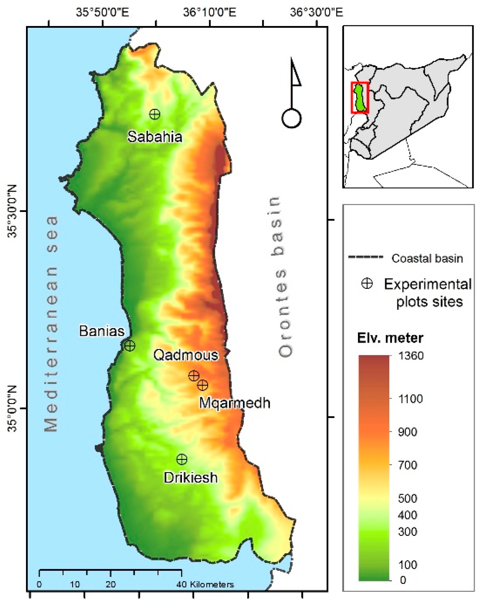
2.1. Study Area
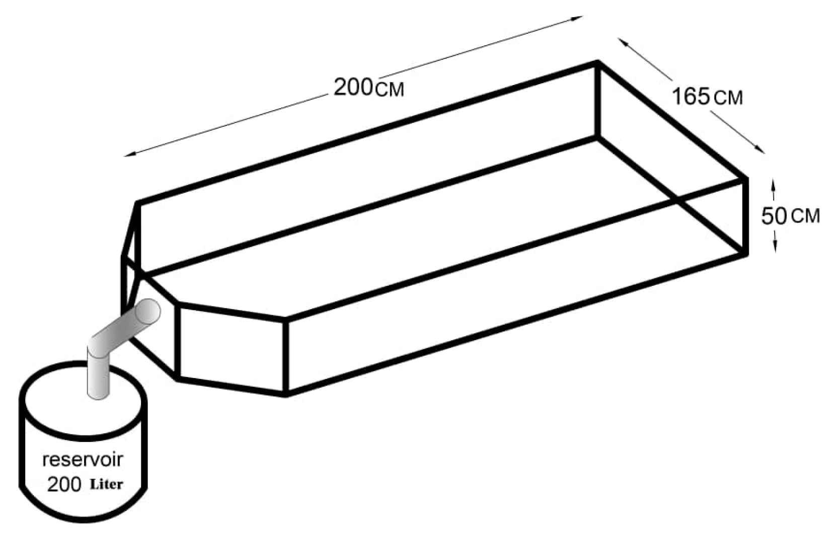
2.2. Experimental Design
2.3. Data Analysis
3. Results
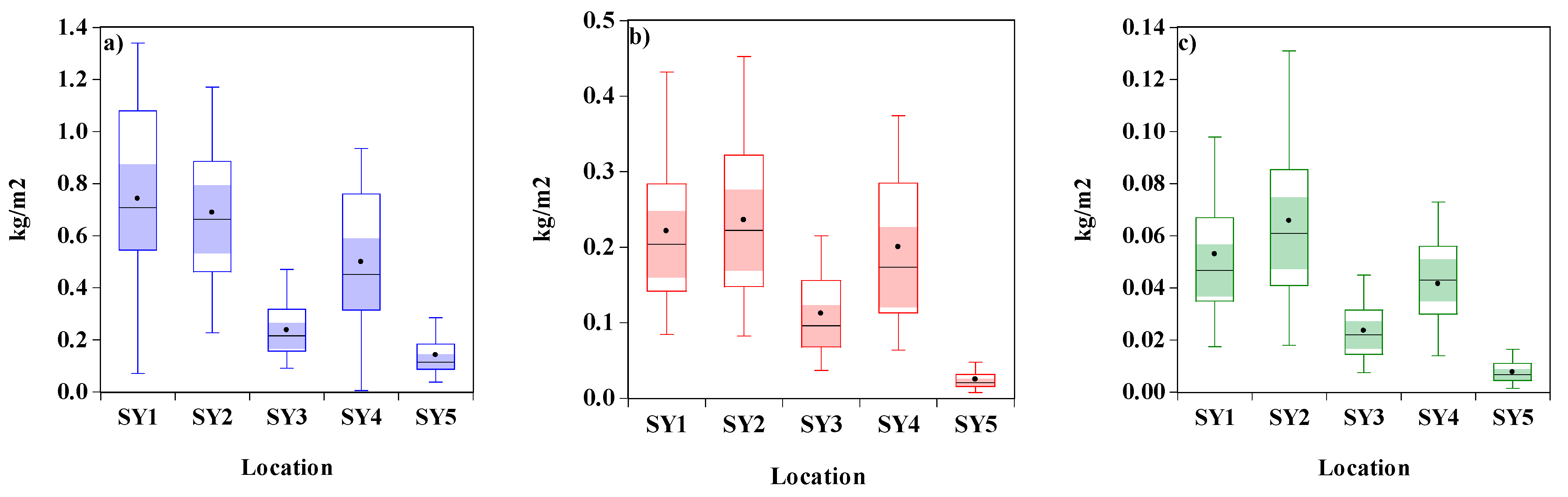
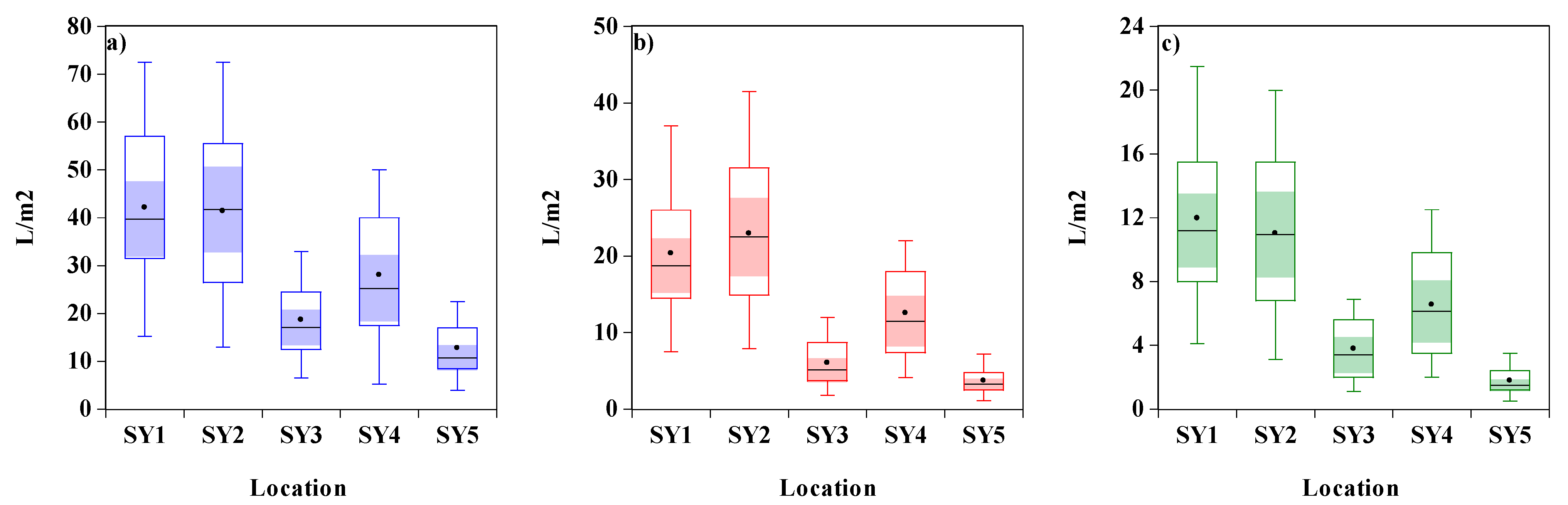
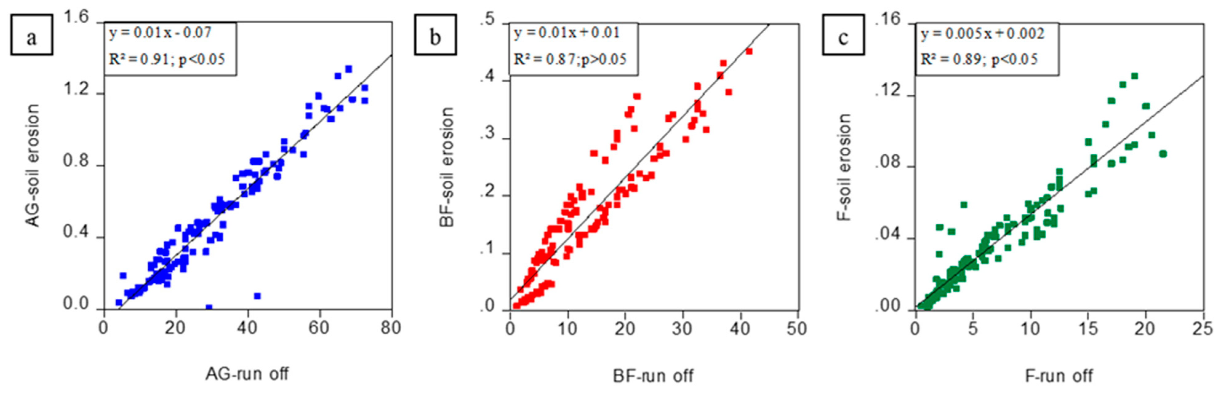
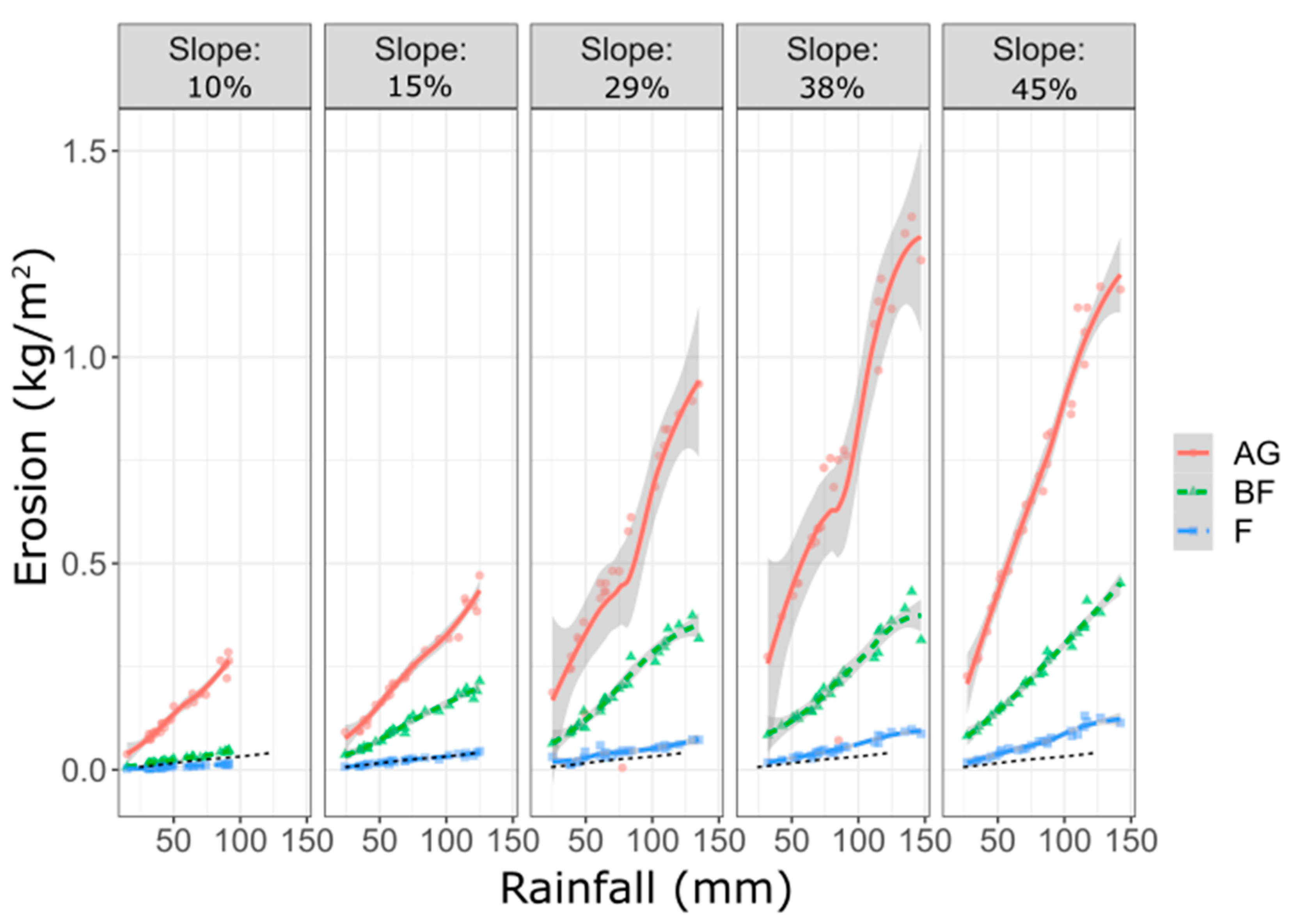
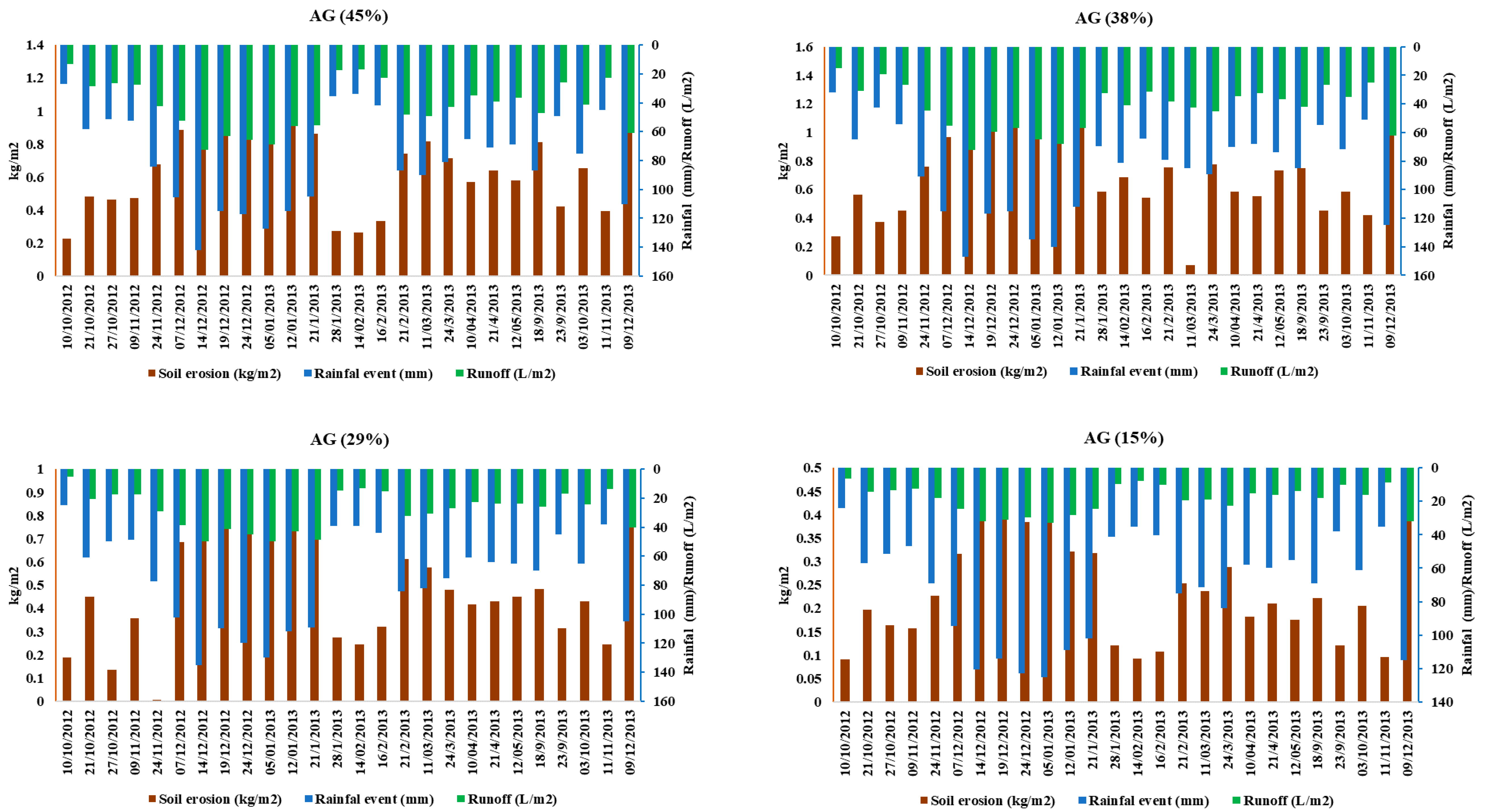
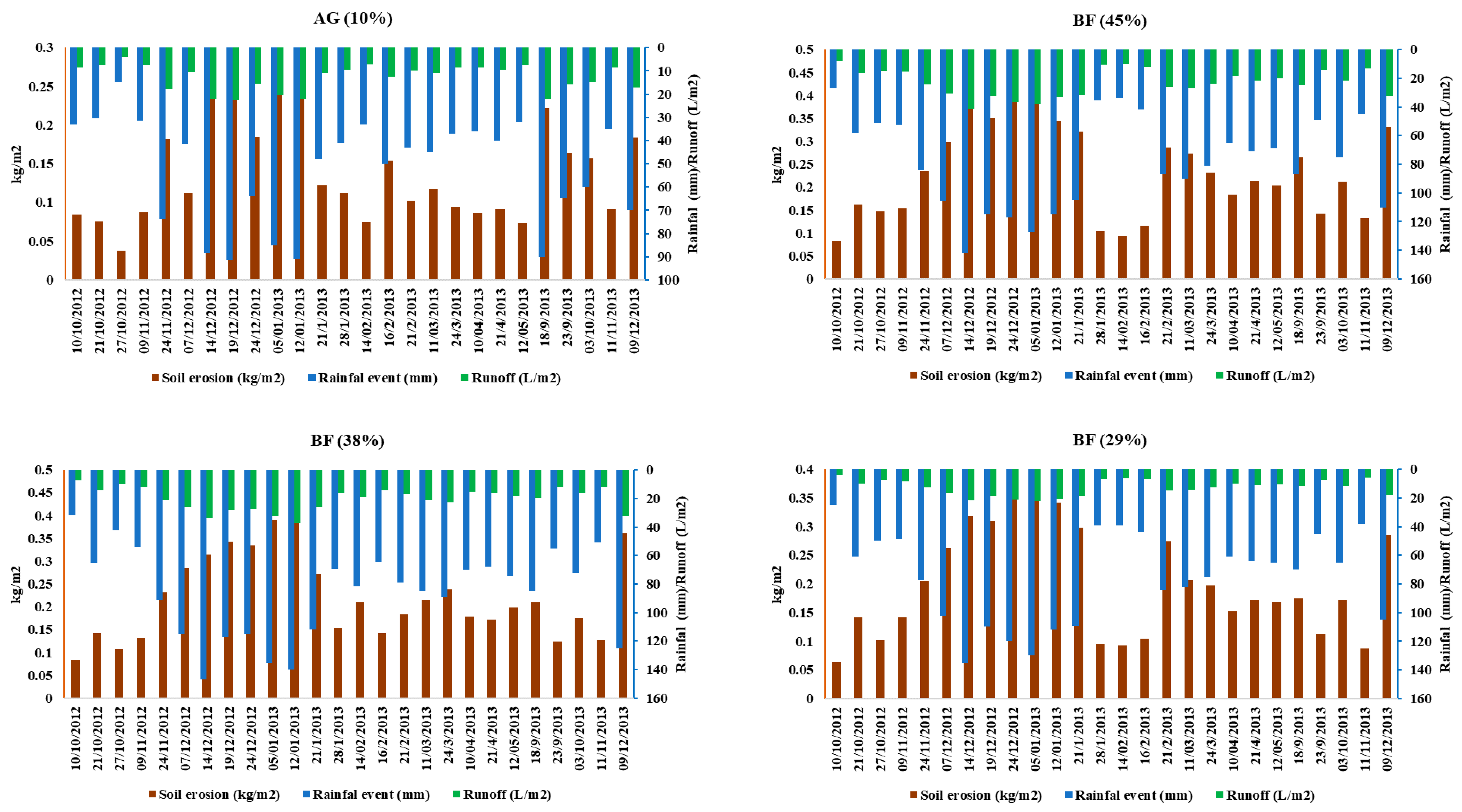
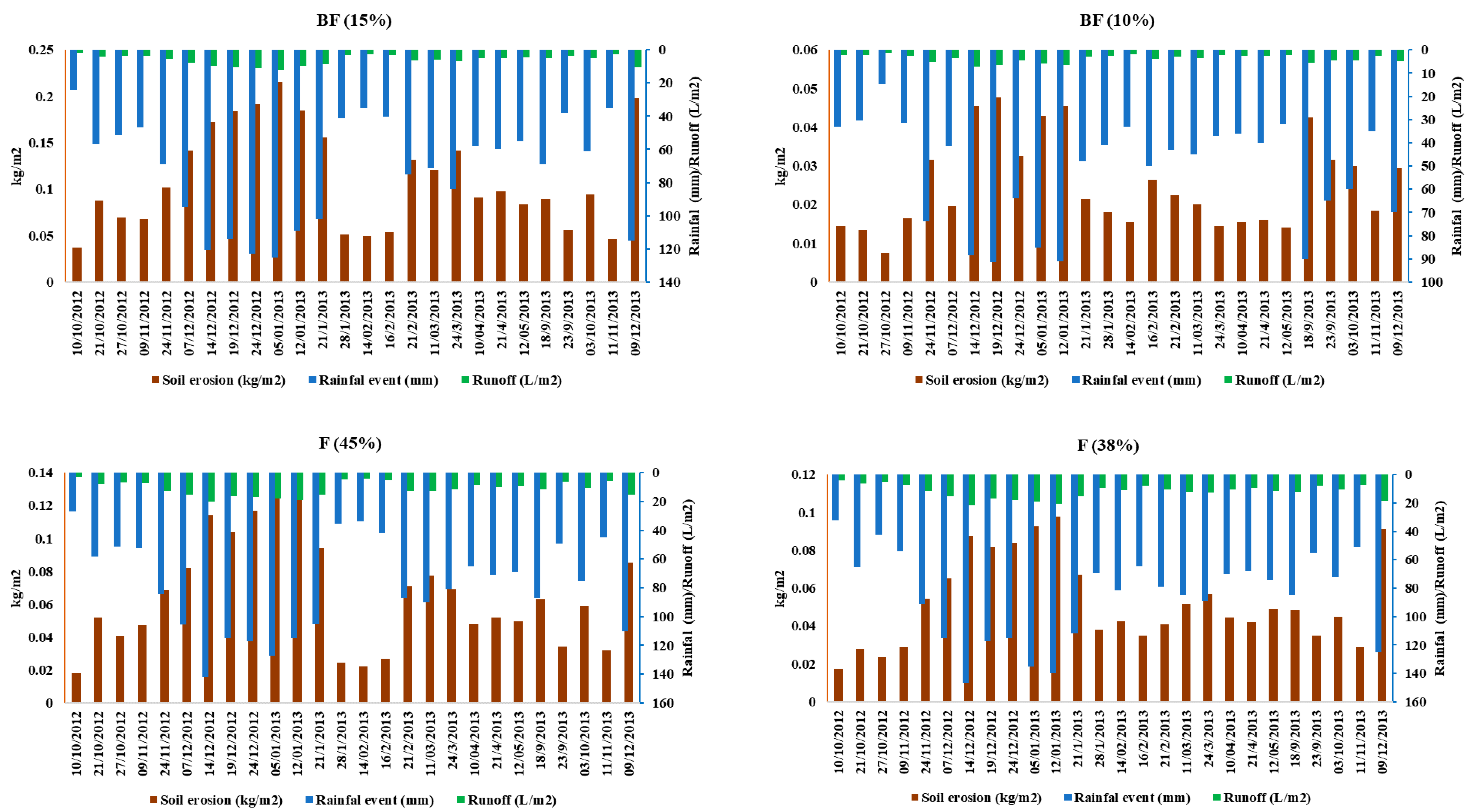
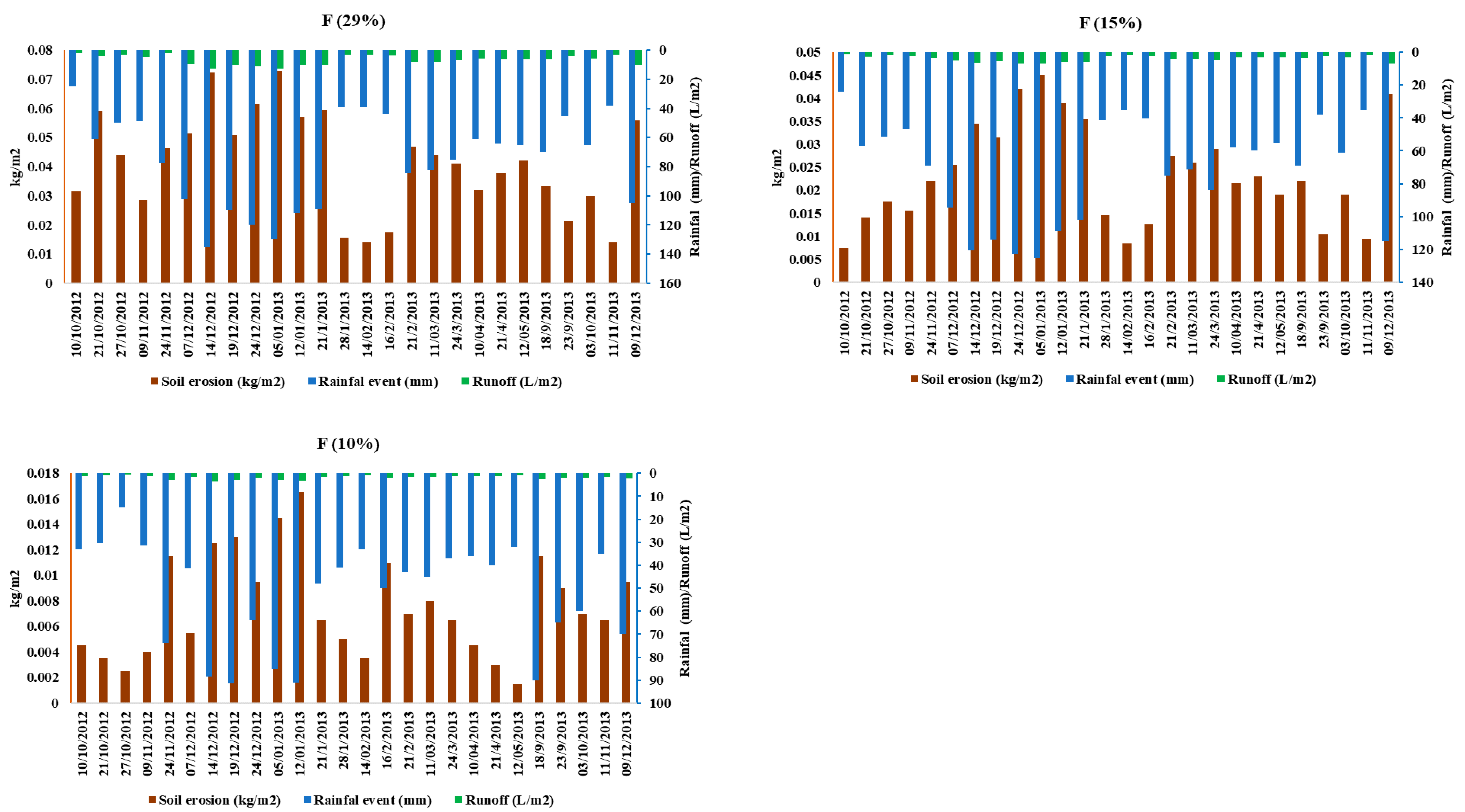
3.1. Soil Water Erosion and Runoff
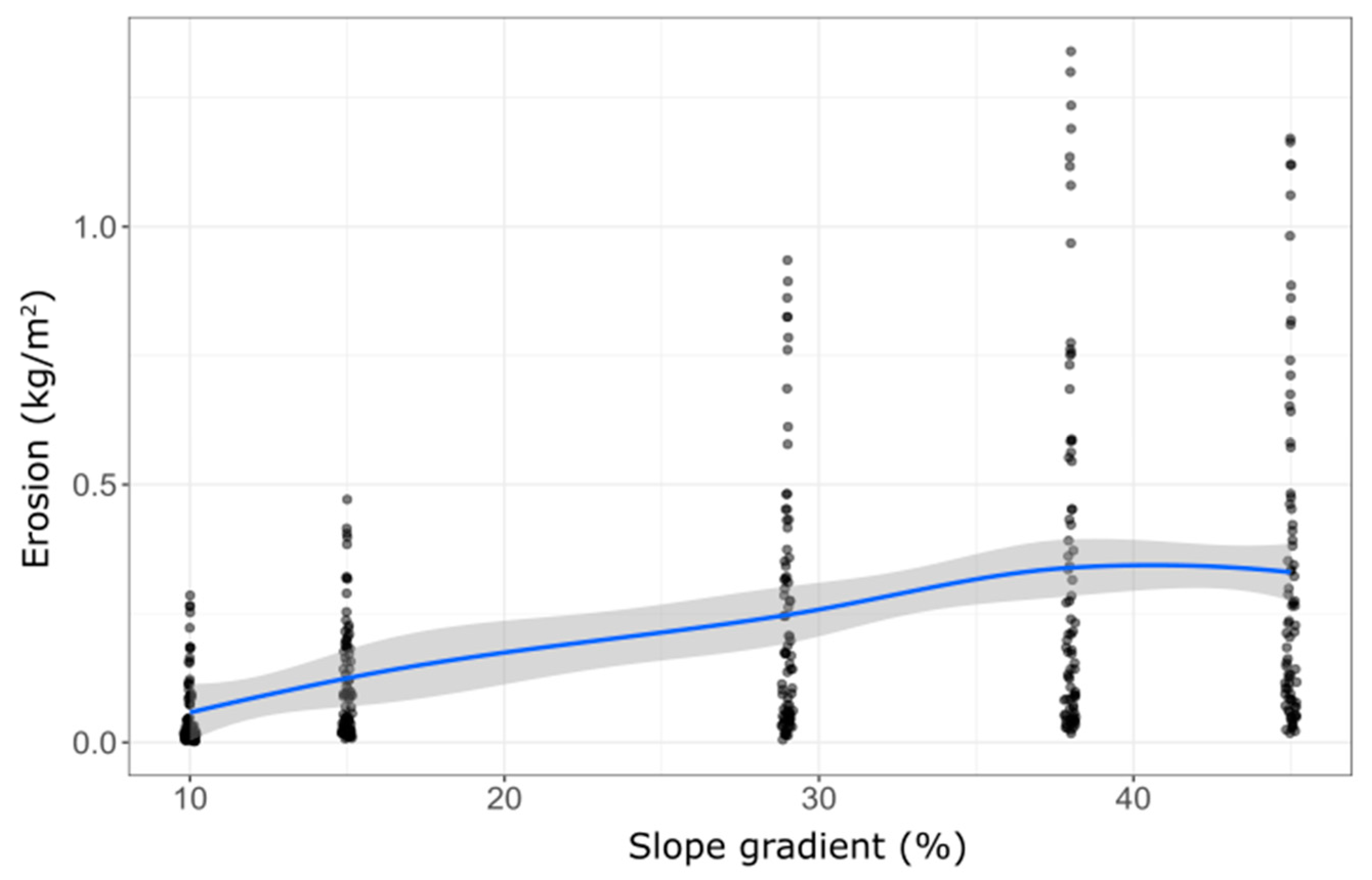
3.2. Impact of Inclination on Soil Water Erosion
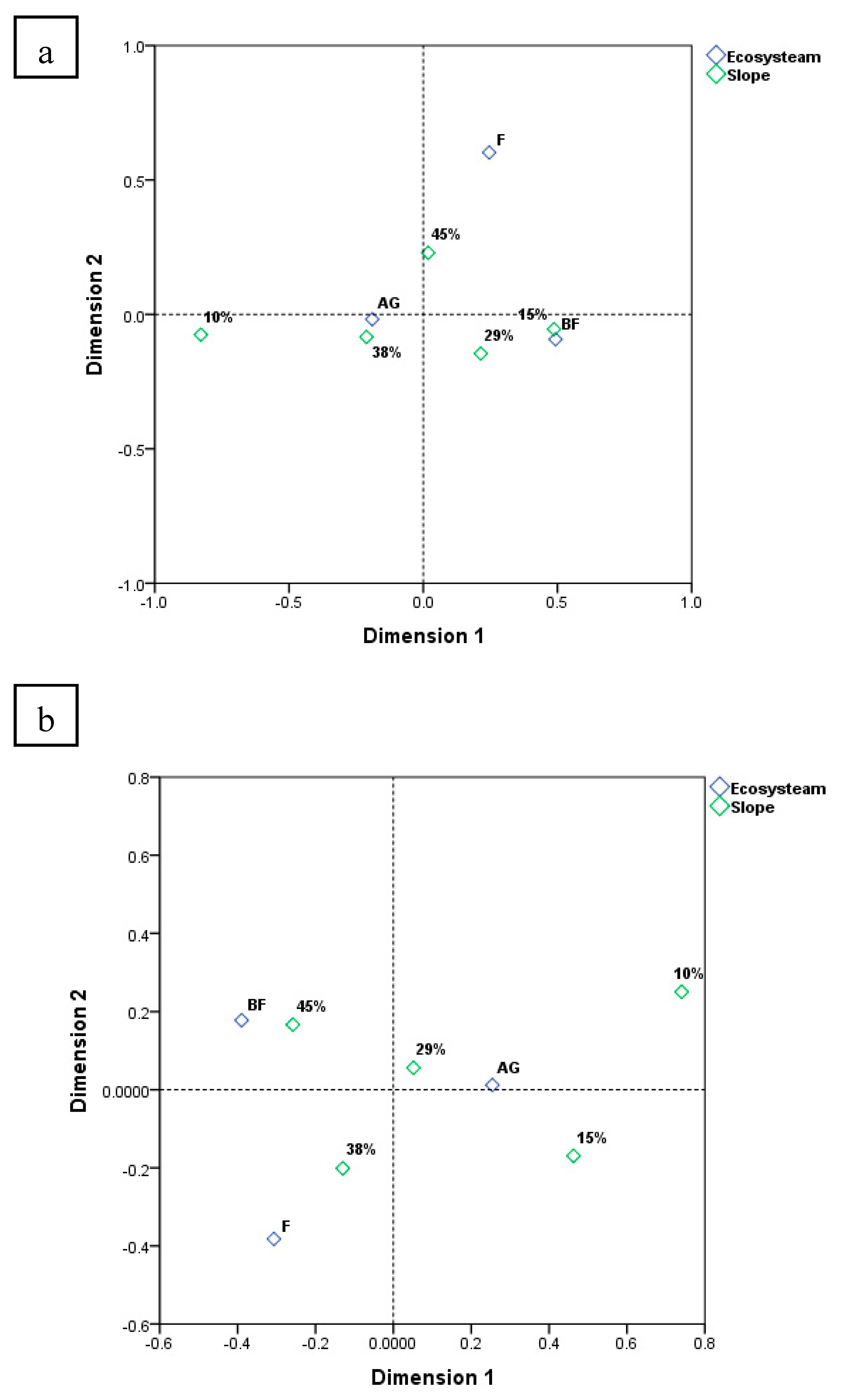
3.3. Multivariate Analysis of Factors and Covariates
4. Discussion
4.1. Criteria to Assess Current Erosion
4.1.1. The Role of Physical Features in Erosion
4.1.2. The Role of Slope Steepness in Erosion
4.1.3. Role of Human Activities in Erosion
4.2. Dimensions of the Current Evaluation
5. Conclusions
- Observed soil loss and runoff were higher in the AG lands, followed by BF and F.
- In the CRoS, land use has the greatest effect on soil erosion, followed by rainfall amount and hillslope inclination.
- Concerning the inclination degree, SY1 (38%) and SY2 (45%) showed the greatest soil erosion and runoff amounts per event, followed by SY4 (29%), SY3 (15%), and SY5 (10%).
- Regardless of the land use type, our results show an absence of statistical differences (p < 0.05) between 10 and 15% inclination, and between 38 and 45%.
- Soil loss was 0.14 ± 0.07 kg/m2 in the AG plots, while it did not exceed 0.1 ± 0.001 kg/m2 in the F plots. Meanwhile, the highest runoff was recorded in the AG plots, which ranged between 3.77 ± 1.62 and 22.95 ± 9.33 L/m2
- In the CRoS, the pairwise comparison among the hillslopes revealed that 29% inclination can be the maximum tolerable threshold to apply urgent soil erosion control measures.
Author Contributions
Funding
Acknowledgments
Conflicts of Interest
Appendix A


References
- Baritz, R.; Wiese, L.; Verbeke, I.; Vargas, R. Voluntary guidelines for sustainable soil management: Global action for healthy soils. In International Yearbook of Soil Law and Policy 2017; Springer: Berlin, Germany, 2018; pp. 17–36. [Google Scholar]
- Brevik, E.C.; Steffan, J.J.; Rodrigo-Comino, J.; Neubert, D.; Burgess, L.C.; Cerdà, A. Connecting the public with soil to improve human health. Eur. J. Soil Sci. 2019, 70, 898–910. [Google Scholar] [CrossRef]
- Fang, H.; Sun, L.; Tang, Z. Effects of rainfall and slope on runoff, soil erosion and rill development: An experimental study using two loess soils. Hydrolog. Process. 2015, 29, 2649–2658. [Google Scholar] [CrossRef]
- Alewell, C.; Egli, M.; Meusburger, K. An attempt to estimate tolerable soil erosion rates by matching soil formation with denudation in Alpine grasslands. J. Soils Sedim. 2015, 15, 1383–1399. [Google Scholar] [CrossRef] [Green Version]
- Wang, L.; Li, X.A.; Li, L.C.; Hong, B.; Liu, J. Experimental study on the physical modeling of loess tunnel-erosion rate. Bull. Eng. Geol. Environ. 2019, 78, 5827–5840. [Google Scholar] [CrossRef]
- Dotterweich, M.; Ivester, A.H.; Hanson, P.R.; Larsen, D.; Dye, D.H. Natural and human-induced prehistoric and historical soil erosion and landscape development in Southwestern Tennessee, USA. Anthropocene 2014, 8, 6–24. [Google Scholar] [CrossRef]
- Romero-Díaz, A.; Ruiz-Sinoga, J.D.; Robledano-Aymerich, F.; Brevik, E.C.; Cerdà, A. Ecosystem responses to land abandonment in Western Mediterranean Mountains. Catena 2017, 149, 824–835. [Google Scholar] [CrossRef] [Green Version]
- Panagos, P.; Borrelli, P.; Meusburger, K.; Yu, B.; Klik, A.; Lim, K.J.; Yang, J.E.; Ni, J.; Miao, C.; Chattopadhyay, N.; et al. Global rainfall erosivity assessment based on high-temporal resolution rainfall records. Sci. Rep. 2017, 7, 1–12. [Google Scholar] [CrossRef] [Green Version]
- Borrelli, P.; Robinson, D.A.; Fleischer, L.R.; Lugato, E.; Ballabio, C.; Alewell, C.; Meusburger, K.; Modugno, S.; Schütt, B.; Ferro, V.; et al. An assessment of the global impact of 21st century land use change on soil erosion. Nat. Commun. 2017, 8, 1–13. [Google Scholar] [CrossRef] [Green Version]
- Gholami, V.; Booij, M.; Tehrani, E.N.; Hadian, M. Spatial soil erosion estimation using an artificial neural network (ANN) and field plot data. Catena 2018, 163, 210–218. [Google Scholar] [CrossRef]
- Prasannakumar, V.; Vijith, H.; Abinod, S.; Geetha, N. Estimation of soil erosion risk within a small mountainous sub-watershed in Kerala, India, using Revised Universal Soil Loss Equation (RUSLE) and geo-information technology. Geosci. Front. 2012, 3, 209–215. [Google Scholar] [CrossRef] [Green Version]
- Efthimiou, N.; Lykoudi, E.; Karavitis, C. Comparative analysis of sediment yield estimations using different empirical soil erosion models. Hydrol. Sci. J. 2017, 62, 2674–2694. [Google Scholar] [CrossRef]
- Ramos, M.; Martinez-Casasnovas, J. Soil moisture variability at different depths in land-levelled vineyards and its influence on crop productivity. J. Hydrol. 2006, 321, 131–146. [Google Scholar] [CrossRef]
- Rodrigo-Comino, J. Five decades of soil erosion research in “terroir”. The State-of-the-Art. Earth Sci. Rev. 2018, 179, 436–447. [Google Scholar] [CrossRef]
- Sannigrahi, S.; Joshi, P.K.; Keesstra, S.; Paul, S.K.; Sen, S.; Roy, P.; Chakraborti, S.; Bhatt, S. Evaluating landscape capacity to provide spatially explicit valued ecosystem services for sustainable coastal resource management. Ocean Coastal Manag. 2019, 182, 104918. [Google Scholar] [CrossRef]
- Sannigrahi, S.; Zhang, Q.; Pilla, F.; Joshi, P.K.; Basu, B.; Keesstra, S.; Roy, P.; Wang, Y.; Sutton, P.C.; Chakraborti, S. Responses of ecosystem services to natural and anthropogenic forcings: A spatial regression based assessment in the world’s largest mangrove ecosystem. Sci. Total Environ. 2020, 715, 137004. [Google Scholar] [CrossRef]
- Norman, L.M. Ecosystem services of riparian restoration: A review of rock detention structures in the madrean archipelago ecoregion. Air Soil Water Res. 2020, 13, 1178622120946337. [Google Scholar] [CrossRef]
- Petrakis, R.E.; Norman, L.M.; Lysaght, O.; Sherrouse, B.C.; Semmens, D.; Bagstad, K.J.; Pritzlaff, R. Mapping perceived social values to support a respondent-defined restoration economy: Case Study in Southeastern Arizona, USA. Air Soil Water Res. 2020, 13, 1178622120913318. [Google Scholar] [CrossRef]
- Cerdà, A.; Lavee, H.; Romero-Diaz, A.; Hooke, J.; Montanarella, L. Soil erosion and degradation in Mediterranean-type ecosystems. Land Degrad. Dev. 2010, 21, 71–74. [Google Scholar] [CrossRef]
- Kaiser, J. Wounding Earth’s Fragile Skin; American Association for the Advancement of Science: Washington, DC, USA, 2004. [Google Scholar]
- Boardman, J.; Poesen, J. Soil Erosion in Europe; John Wiley & Sons: Hoboken, NJ, USA, 2007. [Google Scholar]
- Pimentel, D.; Burgess, M. Soil erosion threatens food production. Agriculture 2013, 3, 443–463. [Google Scholar] [CrossRef] [Green Version]
- Abdo, H.G. Impacts of war in Syria on vegetation dynamics and erosion risks in Safita area, Tartous, Syria. Reg. Environ. Change 2018, 18, 1707–1719. [Google Scholar] [CrossRef]
- Falcão, C.J.L.M.; de Araújo Duarte, S.M.; da Silva Veloso, A. Estimating potential soil sheet Erosion in a Brazilian semiarid county using USLE, GIS, and remote sensing data. Environ. Monit. Assess. 2020, 192, 47. [Google Scholar] [CrossRef] [PubMed]
- FAO. Status of the world’s soil resources (SWSR)–main report. In Food and Agriculture Organization of the United Nations and Intergovernmental Technical Panel on Soils; FAO, I: Rome, Italy, 2015; Volume 650. [Google Scholar]
- Hatna, E.; Bakker, M.M. Abandonment and expansion of arable land in Europe. Ecosystems 2011, 14, 720–731. [Google Scholar] [CrossRef] [Green Version]
- Arnáez, J.; Lana-Renault, N.; Lasanta, T.; Ruiz-Flaño, P.; Castroviejo, J. Effects of farming terraces on hydrological and geomorphological processes. A review. Catena 2015, 128, 122–134. [Google Scholar] [CrossRef] [Green Version]
- Dutta, S. Soil erosion, sediment yield and sedimentation of reservoir: A review. Modeling Earth Syst. Environ. 2016, 2, 123. [Google Scholar] [CrossRef] [Green Version]
- Angulo-Martinez, M.; Beguería, S.; Navas, A.; Machin, J. Splash erosion under natural rainfall on three soil types in NE Spain. Geomorphology 2012, 175, 38–44. [Google Scholar] [CrossRef]
- Klik, A.; Rosner, J. Long-term experience with conservation tillage practices in Austria: Impacts on soil erosion processes. Soil Tillage Res. 2020, 203, 104669. [Google Scholar] [CrossRef]
- Martínez-Mena, M.; Carrillo-López, E.; Boix-Fayos, C.; Almagro, M.; Franco, N.G.; Díaz-Pereira, E.; Montoya, I.; de Vente, J. Long-term effectiveness of sustainable land management practices to control runoff, soil erosion, and nutrient loss and the role of rainfall intensity in Mediterranean rainfed agroecosystems. Catena 2020, 187, 104352. [Google Scholar] [CrossRef]
- Chen, X.; Liang, Z.; Zhang, Z.; Zhang, L. Effects of soil and water conservation measures on runoff and sediment yield in red soil slope farmland under natural rainfall. Sustainability 2020, 12, 3417. [Google Scholar] [CrossRef] [Green Version]
- Madarász, B.; Bádonyi, K.; Csepinszky, B.; Mika, J.; Kertész, Á. Conservation tillage for rational water management and soil conservation. Hung. Geograph. Bull. 2011, 60, 117–133. [Google Scholar]
- Koch, H.J.; Stockfisch, N. Loss of soil organic matter upon ploughing under a loess soil after several years of conservation tillage. Soil Tillage Res. 2006, 86, 73–83. [Google Scholar] [CrossRef]
- Armand, R.; Bockstaller, C.; Auzet, A.V.; van Dijk, P. Runoff generation related to intra-field soil surface characteristics variability: Application to conservation tillage context. Soil Tillage Res. 2009, 102, 27–37. [Google Scholar] [CrossRef]
- García-Ruiz, J.M.; Nadal-Romero, E.; Lana-Renault, N.; Beguería, S. Erosion in Mediterranean landscapes: Changes and future challenges. Geomorphology 2013, 198, 20–36. [Google Scholar] [CrossRef] [Green Version]
- Raclot, D.; le Bissonnais, Y.; Annabi, M.; Sabir, M. Challenges for mitigating Mediterranean soil erosion under global change. Mediterr. Reg. Under Clim. Change 2016, 311. [Google Scholar]
- Amate, J.I.; de Molina, M.G.; Vanwalleghem, T.; Fernández, D.S.; Gómez, J.A. Erosion in the Mediterranean: The case of olive groves in the south of Spain (1752–2000). Environ. Hist. 2013, 18, 360–382. [Google Scholar] [CrossRef]
- Takken, I.; Govers, G.; Ciesiolka, C.; Silburn, D.; Loch, R. Factors Influencing the Velocity-Discharge Relationship in Rills; IAHS Publication: Oxfordshire, UK, 1998; pp. 63–70. [Google Scholar]
- Bradford, J.; Foster, G. Interrill soil erosion and slope steepness factors. Soil Sci. Soc. Am. J. 1996, 60, 909–915. [Google Scholar] [CrossRef]
- Nearing, M.; Deer-Ascough, L.; Laflen, J. Sensitivity analysis of the WEPP hillslope profile erosion model. Trans. ASAE 1990, 33, 839–0849. [Google Scholar] [CrossRef]
- Rojo, L. Plan nacional de restauración hidrológico-forestal y control de la erosión; Memoria, Tomo I: Mapas Tomo II; ICONA: Madrid, Spain, 1990. [Google Scholar]
- Irvem, A.; Topaloğlu, F.; Uygur, V. Estimating spatial distribution of soil loss over Seyhan River Basin in Turkey. J. Hydrol. 2007, 336, 30–37. [Google Scholar] [CrossRef]
- Trabucchi, M.; Puente, C.; Comin, F.A.; Olague, G.; Smith, S.V. Mapping erosion risk at the basin scale in a Mediterranean environment with opencast coal mines to target restoration actions. Reg. Environ. Change 2012, 12, 675–687. [Google Scholar] [CrossRef] [Green Version]
- Farhan, Y.; Zregat, D.; Farhan, I. Spatial estimation of soil erosion risk using RUSLE approach, RS, and GIS techniques: A case study of Kufranja watershed, Northern Jordan. J. Water Res. Prot. 2013, 5, 1247. [Google Scholar] [CrossRef] [Green Version]
- Verheijen, F.G.; Jones, R.J.; Rickson, R.; Smith, C. Tolerable versus actual soil erosion rates in Europe. Earth Sci. Rev. 2009, 94, 23–38. [Google Scholar] [CrossRef] [Green Version]
- Kouli, M.; Soupios, P.; Vallianatos, F. Soil erosion prediction using the revised universal soil loss equation (RUSLE) in a GIS framework, Chania, Northwestern Crete, Greece. Environ. Geol. 2009, 57, 483–497. [Google Scholar] [CrossRef]
- Mohammed, S.; Khallouf, A.; Alshiehabi, O.; Pham, Q.B.; Linh, N.T.T.; Anh, D.T.; Harsányi, E. Predicting soil erosion hazard in Lattakia governorate (W Syria). Int. J. Sediment Res. 2020. In press. [Google Scholar]
- Al Bakeer, H. Report About the Agricultural Situation in Syria; Institute of Development Studies: Brighton, UK, 2018. [Google Scholar]
- GCSAR: General Commission for Scientific Agricultural Research. Natural Resources in the Costal Region of Syria; Ministry of Agriculture: Damascus, Syria, 2013; p. 159. (In Arabic)
- Abdo, H.; Salloum, J. Mapping the soil loss in Marqya basin: Syria using RUSLE model in GIS and RS techniques. Environ. Earth Sci. 2017, 76, 114. [Google Scholar] [CrossRef]
- Hazem, G.A. Geo-modeling approach to predicting of erosion risks utilizing RS and GIS data: A case study of Al-Hussain Basin, Tartous, Syria. J. Environ. Geol. 2017, 1, 1–4. [Google Scholar]
- Mohammed, S.; Kbibo, I.; Alshihabi, O.; Mahfoud, E. Studying rainfall changes and water erosion of soil by using the WEPP model in Lattakia, Syria. J. Agric. Sci. Belgrad. 2016, 61, 375–386. [Google Scholar] [CrossRef]
- Barakat, M.; Mahfoud, I.; Kwyes, A. Study of soil erosion risk in the basin of Northern Al-Kabeer river at Lattakia-Syria using remote sensing andGIS techniques. Mesop. J. Mar. Sci. 2014, 29, 29–44. [Google Scholar]
- Al-Ali, Y.A.Z.; Kheder, R. Studying the effect of forest fire on soil erosion and loss of some mineral elements in the forest of ein al-jaouz/tartous. Biol. Sci. Ser. 2014, 36, 277–290. (In Arabic) [Google Scholar]
- Sarah, P. Soil organic matter and land degradation in semi-arid area, Israel. Catena 2006, 67, 50–55. [Google Scholar] [CrossRef]
- Stavi, I.; Ragolsky, G.; Shem-Tov, R.; Shlomi, Y.; Ackermann, O.; Rueff, H.; Lekach, J. Ancient through mid-twentieth century runoff harvesting agriculture in the hyper-arid Arava Valley of Israel. Catena 2018, 162, 80–87. [Google Scholar] [CrossRef]
- Lavee, H.; Poesen, J.; Yair, A. Evidence of high efficiency water-harvesting by ancient farmers in the Negev Desert, Israel. J. Arid Environ. 1997, 35, 341–348. [Google Scholar] [CrossRef]
- Abdo, H.G. Evolving a total-evaluation map of flash flood hazard for hydro-prioritization based on geohydromorphometric parameters and GIS–RS manner in Al-Hussain river basin, Tartous, Syria. Nat. Hazards 2020, 104, 681–703. [Google Scholar] [CrossRef]
- Ministry of Oil and Natural Resoures. Geology Map of Syria. 2009. Available online: https://geology-sy.org/ (accessed on 9 September 2020).
- Directoriet of Meteorology. Weather Data of Syria; Syrian Ministry of Defense: Damascus, Syria, 2019.
- Mohammed, S.; Khallouf, A.; Kiwan, S.; Alhenawi, S.; Ali, H.; Harsányi, E.; Kátai, J.; Habib, H. Characterization of Major Soil Orders in Syria. Eurasian Soil Sci. 2020, 53, 420–429. [Google Scholar] [CrossRef]
- Ministry of Agriculture and Agrarian Reform (MoAAR). The Agricultural Investment Map in the Syrian Arab Republic; Ministry of Agriculture and Agrarian Reform (MoAAR): Damascus, Syria, 2020.
- Kbibo, I.; Ibrahim, J.; Bou-Issa, A. Studying the effect of soil erosion for eight different systems with different slopes in the coastal area under forests, burned forest and planted soil system. Tishreen Univ. J. Res. Sci. Stud. Biol. Sci. Ser 2017, 39, 25–38. [Google Scholar]
- Mohammed, S.; Al-Ebraheem, A.; Holb, I.J.; Alsafadi, K.; Dikkeh, M.; Pham, Q.B.; Linh, N.T.T.; Szabo, S. Soil management effects on soil water erosion and runoff in central Syria—A comparative evaluation of general linear model and random forest regression. Water 2020, 12, 2529. [Google Scholar] [CrossRef]
- Safwan, M.; Alaa, K.; Omran, A.; Quoc, B.P.; Nguyen, T.T.L.; Van, N.T.; Duong, T.A.; Endre, H. Predicting soil erosion hazard in Lattakia Governorate (W Syria). Int. J. Sediment Res. 2020. [Google Scholar] [CrossRef]
- Wischmeier, W.H.; Smith, D.D. Predicting Rainfall Erosion Losses: A Guide to Conservation Planning; Department of Agriculture, Science and Education Administration: Washington, DC, USA, 1978. [Google Scholar]
- McDonald, J.H. Handbook of Biological Statistics; Sparky House Publishing: Baltimore, MD, USA, 2009; Volume 2. [Google Scholar]
- Field, A. Discovering Statistics Using IBM SPSS Statistics; Sage: Thousand Oacs, CA, USA, 2013. [Google Scholar]
- McCullough, B.D. Econometric Software Reliability: EViews, LIMDEP, SHAZAM and TSP; JSTOR: New York, NY, USA, 1999. [Google Scholar]
- Team, R.C. R: A Language and Environment For Statistical Computing.(Version 3.6). 2019. Available online: http://www.r-project.org/index.html (accessed on 9 May 2020).
- Gallucci, M. R Package Version 2.0.5. 2020. Available online: https://gamlj.github.io/ (accessed on 9 May 2020).
- Feng, T.; Wei, W.; Chen, L.; Rodrigo-Comino, J.; Die, C.; Feng, X.; Ren, K.; Brevik, E.C.; Yu, Y. Assessment of the impact of different vegetation patterns on soil erosion processes on semiarid loess slopes. Earth Surf. Process. Landf. 2018, 43, 1860–1870. [Google Scholar] [CrossRef]
- Rodrigo-Comino, J.; Brevik, E.C.; Cerdà, A. The age of vines as a controlling factor of soil erosion processes in Mediterranean vineyards. Sci. Total Environ. 2018, 616, 1163–1173. [Google Scholar] [CrossRef] [Green Version]
- DeLong, S.B.; Youberg, A.M.; de Long, W.M.; Murphy, B.P. Post-wildfire landscape change and erosional processes from repeat terrestrial LIDAR in a steep headwater catchment, Chiricahua Mountains, Arizona, USA. Geomorphology 2018, 300, 13–30. [Google Scholar] [CrossRef]
- Cerdà, A.; Morera, A.G.; Bodí, M.B. Soil and water losses from new citrus orchards growing on sloped soils in the western Mediterranean basin. Earth Surface Process. Landf. J. Br. Geomorphol. Res. Group 2009, 34, 1822–1830. [Google Scholar] [CrossRef]
- Chaplot, V.; le Bissonnais, Y. Field measurements of interrill erosion under different slopes and plot sizes. Earth Surface Process. Landf. J. Br. Geomorphol. Res. Group 2000, 25, 145–153. [Google Scholar] [CrossRef]
- Comino, J.R.; Sinoga, J.R.; González, J.S.; Guerra-Merchán, A.; Seeger, M.; Ries, J. High variability of soil erosion and hydrological processes in Mediterranean hillslope vineyards (Montes de Málaga, Spain). Catena 2016, 145, 274–284. [Google Scholar] [CrossRef]
- Kairis, O.; Karavitis, C.; Kounalaki, A.; Salvati, L.; Kosmas, C. The effect of land management practices on soil erosion and land desertification in an olive grove. Soil Use Manag. 2013, 29, 597–606. [Google Scholar] [CrossRef]
- Aksoy, H.; Kavvas, M.L. A review of hillslope and watershed scale erosion and sediment transport models. Catena 2005, 64, 247–271. [Google Scholar] [CrossRef]
- Assouline, S.; Ben-Hur, M. Effects of rainfall intensity and slope gradient on the dynamics of interrill erosion during soil surface sealing. Catena 2006, 66, 211–220. [Google Scholar] [CrossRef]
- Defersha, M.; Quraishi, S.; Melesse, A.M. The effect of slope steepness and antecedent moisture content on interrill erosion, runoff and sediment size distribution in the highlands of Ethiopia. Hydrol. Earth Syst. Sci. 2011, 15, 2367–2375. [Google Scholar] [CrossRef] [Green Version]
- Barneveld, R.; Bruggeman, A.; Sterk, G.; Turkelboom, F. Comparison of two methods for quantification of tillage erosion rates in olive orchards of north-west Syria. Soil Tillage Res. 2009, 103, 105–112. [Google Scholar] [CrossRef]
- Fonseca, F.; de Figueiredo, T.; Nogueira, C.; Queirós, A. Effect of prescribed fire on soil properties and soil erosion in a Mediterranean mountain area. Geoderma 2017, 307, 172–180. [Google Scholar] [CrossRef]
- Jenny, J.P.; Koirala, S.; Gregory-Eaves, I.; Francus, P.; Niemann, C.; Ahrens, B.; Brovkin, V.; Baud, A.; Ojala, A.E.; Normandeau, A.; et al. Human and climate global-scale imprint on sediment transfer during the Holocene. Proc. Nat. Acad. Sci. USA 2019, 116, 22972–22976. [Google Scholar] [CrossRef] [Green Version]
- Lieskovský, J.; Kenderessy, P. Modelling the effect of vegetation cover and different tillage practices on soil erosion in vineyards: A case study in Vráble (Slovakia) using WATEM/SEDEM. Land Degrad. Dev. 2014, 25, 288–296. [Google Scholar] [CrossRef]
- Gao, Y.; Dang, X.; Yu, Y.; Li, Y.; Liu, Y.; Wang, J. Effects of tillage methods on soil carbon and wind erosion. Land Degrad. Dev. 2016, 27, 583–591. [Google Scholar] [CrossRef]
- Paul, B.K.; Vanlauwe, B.; Ayuke, F.; Gassner, A.; Hoogmoed, M.; Hurisso, T.; Koala, S.; Lelei, D.; Ndabamenye, T.; Six, J. Medium-term impact of tillage and residue management on soil aggregate stability, soil carbon and crop productivity. Agric. Ecosyst. Environ. 2013, 164, 14–22. [Google Scholar] [CrossRef]
- Kasper, M.; Buchan, G.; Mentler, A.; Blum, W. Influence of soil tillage systems on aggregate stability and the distribution of C and N in different aggregate fractions. Soil Tillage Res. 2009, 105, 192–199. [Google Scholar] [CrossRef]
- Wang, Y.; Zhang, J.; Zhang, Z. Influences of intensive tillage on water-stable aggregate distribution on a steep hillslope. Soil Tillage Res. 2015, 151, 82–92. [Google Scholar] [CrossRef]
- Bayat, F.; Monfared, A.B.; Jahansooz, M.R.; Esparza, E.T.; Keshavarzi, A.; Morera, A.G.; Fernández, M.P.; Cerdà, A. Analyzing long-term soil erosion in a ridge-shaped persimmon plantation in eastern Spain by means of ISUM measurements. Catena 2019, 183, 104176. [Google Scholar] [CrossRef]
- Bogunovic, I.; Telak, L.J.; Pereira, P. Experimental comparison of runoff generation and initial soil erosion between vineyards and croplands of eastern Croatia: A case study. Air Soil Water Res. 2020, 13, 1178622120928323. [Google Scholar] [CrossRef]
- Lin, Q.; Xu, Q.; Wu, F.; Li, T. Effects of wheat in regulating runoff and sediment on different slope gradients and under different rainfall intensities. Catena 2019, 183, 104196. [Google Scholar] [CrossRef]
- Ayoubi, S.; Mokhtari, J.; Mosaddeghi, M.R.; Zeraatpisheh, M. Erodibility of calcareous soils as influenced by land use and intrinsic soil properties in a semiarid region of central Iran. Environ. Monit. Assess. 2018, 190, 192. [Google Scholar] [CrossRef]
- Boix-Fayos, C.; Calvo-Cases, A.; Imeson, A.; Soriano-Soto, M. Influence of soil properties on the aggregation of some Mediterranean soils and the use of aggregate size and stability as land degradation indicators. Catena 2001, 44, 47–67. [Google Scholar] [CrossRef]
- Kayet, N.; Pathak, K.; Chakrabarty, A.; Sahoo, S. Evaluation of soil loss estimation using the RUSLE model and SCS-CN method in hillslope mining areas. Int. Soil Water Conserv. Res. 2018, 6, 31–42. [Google Scholar] [CrossRef]
- Novara, A.; Gristina, L.; Bodí, M.; Cerdà, A. The impact of fire on redistribution of soil organic matter on a Mediterranean hillslope under maquia vegetation type. Land Degrad. Dev. 2011, 22, 530–536. [Google Scholar] [CrossRef]
- Toubal, A.K.; Achite, M.; Ouillon, S.; Dehni, A. Soil erodibility mapping using the RUSLE model to prioritize erosion control in the Wadi Sahouat basin, North-West of Algeria. Environ. Monit. Assess. 2018, 190, 210. [Google Scholar] [CrossRef] [PubMed]
- Cerdà, A.; Jurgensen, M.; Bodi, M. Effects of ants on water and soil losses from organically-managed citrus orchards in eastern Spain. Biologia 2009, 64, 527–531. [Google Scholar] [CrossRef] [Green Version]
- Laudicina, V.A.; Novara, A.; Barbera, V.; Egli, M.; Badalucco, L. Long-term tillage and cropping system effects on chemical and biochemical characteristics of soil organic matter in a Mediterranean semiarid environment. Land Degrad. Dev. 2015, 26, 45–53. [Google Scholar] [CrossRef]
- Fullen, M.A.; Catt, J.A. Soil Management: Problems and Solutions; Routledge: London, UK, 2004; p. 269. [Google Scholar]
- Conforti, M.; Buttafuoco, G.; Leone, A.P.; Aucelli, P.P.; Robustelli, G.; Scarciglia, F. Studying the relationship between water-induced soil erosion and soil organic matter using Vis–NIR spectroscopy and geomorphological analysis: A case study in southern Italy. Catena 2013, 110, 44–58. [Google Scholar] [CrossRef]
- Giménez-Morera, A.; Sinoga, J.R.; Cerdà, A. The impact of cotton geotextiles on soil and water losses from Mediterranean rainfed agricultural land. Land Degrad. Dev. 2010, 21, 210–217. [Google Scholar] [CrossRef]
- Cerda, A.; Rodrigo-Comino, J.; Novara, A.; Brevik, E.C.; Vaezi, A.R.; Pulido, M.; Gimenez-Morera, A.; Keesstra, S.D. Long-term impact of rainfed agricultural land abandonment on soil erosion in the Western Mediterranean basin. Prog. Phys. Geogr. Earth Environ. 2018, 42, 202–219. [Google Scholar] [CrossRef]
- Schmid, T.; Rodríguez-Rastrero, M.; Escribano, P.; Palacios-Orueta, A.; Ben-Dor, E.; Plaza, A.; Milewski, R.; Huesca, M.; Bracken, A.; Cicuéndez, V.; et al. Characterization of soil erosion indicators using hyperspectral data from a Mediterranean rainfed cultivated region. IEEE J. Sel. Topics Appl. Earth Obs. Remote Sens. 2015, 9, 845–860. [Google Scholar] [CrossRef]
- Zhao, G.; Mu, X.; Wen, Z.; Wang, F.; Gao, P. Soil erosion, conservation, and eco-environment changes in the Loess Plateau of China. Land Degrad. Dev. 2013, 24, 499–510. [Google Scholar] [CrossRef]
- Ochoa, P.; Fries, A.; Mejia, D.; Burneo, J.; Ruíz-Sinoga, J.; Cerdà, A. Effects of climate, land cover and topography on soil erosion risk in a semiarid basin of the Andes. Catena 2016, 140, 31–42. [Google Scholar] [CrossRef]
- Dunjó, G.; Pardini, G.; Gispert, M. The role of land use–land cover on runoff generation and sediment yield at a microplot scale, in a small Mediterranean catchment. J. Arid Environ. 2004, 57, 239–256. [Google Scholar] [CrossRef]
- Bajocco, S.; de Angelis, A.; Perini, L.; Ferrara, A.; Salvati, L. The impact of land use/land cover changes on land degradation dynamics: A Mediterranean case study. Environ. Manag. 2012, 49, 980–989. [Google Scholar] [CrossRef] [PubMed]
- Lucas-Borja, M.E.; Zema, D.A.; Carrà, B.G.; Cerdà, A.; Plaza-Alvarez, P.A.; Cózar, J.S.; Gonzalez-Romero, J.; Moya, D.; de las Heras, J. Short-term changes in infiltration between straw mulched and non-mulched soils after wildfire in Mediterranean forest ecosystems. Ecol. Eng. 2018, 122, 27–31. [Google Scholar] [CrossRef] [Green Version]
- Rodrigo-Comino, J.; Giménez-Morera, A.; Panagos, P.; Pourghasemi, H.; Pulido, M.; Cerdà, A. The potential of straw mulch as a nature-based solution in olive groves treated with glyphosate. A biophysical and socio-economic assessment. Land Degrad. Dev. 2020, 31, 1877–1889. [Google Scholar] [CrossRef]
- Alliaume, F.; Rossing, W.; Tittonell, P.; Jorge, G.; Dogliotti, S. Reduced tillage and cover crops improve water capture and reduce erosion of fine textured soils in raised bed tomato systems. Agric. Ecosyst. Environ. 2014, 183, 127–137. [Google Scholar] [CrossRef]
- Seitz, S.; Goebes, P.; Puerta, V.L.; Pereira, E.I.P.; Wittwer, R.; Six, J.; van der Heijden, M.G.; Scholten, T. Conservation tillage and organic farming reduce soil erosion. Agron. Sustain. Dev. 2019, 39, 4. [Google Scholar] [CrossRef] [Green Version]
- Wauters, E.; Bielders, C.; Poesen, J.; Govers, G.; Mathijs, E. Adoption of soil conservation practices in Belgium: An examination of the theory of planned behaviour in the agri-environmental domain. Land Use Policy 2010, 27, 86–94. [Google Scholar] [CrossRef]
- Zuazo, V.D.; Ruiz, J.A.; Raya, A.M.; Tarifa, D.F. Impact of erosion in the taluses of subtropical orchard terraces. Agric. Ecosyst. Environ. 2005, 107, 199–210. [Google Scholar] [CrossRef]


| Location | Code | X | Y | Slope (%) | Rainfall (mm) |
|---|---|---|---|---|---|
| Drikiesh | SY1 | 36°07′ | 34°53′ | 38% | 965 |
| Qadmous | SY2 | 36°09′ | 35°05′ | 45% | 936 |
| Banias | SY3 | 35°56′ | 35°10′ | 15% | 914 |
| Mqarmedh | SY4 | 36°10′ | 35°04′ | 29% | 890 |
| Sabahia | SY5 | 36°00′ | 35°45′ | 10% | 765 |
| Code | Agricultural Land (AG) | Burnt Forest (BF) | Forest Land (F) | |||||||||
|---|---|---|---|---|---|---|---|---|---|---|---|---|
| Sand | Silt | Clay | K | Sand | Silt | Clay | K | Sand | Silt | Clay | K | |
| SY1 | 31.5 | 27.0 | 41.5 | 0.154 | 30.5 | 32.5 | 37.0 | 0.128 | 32.5 | 35.5 | 32.0 | 0.074 |
| SY2 | 23.0 | 35.0 | 42.0 | 0.236 | 23.0 | 35.0 | 42.0 | 0.215 | 24.0 | 36.0 | 40.0 | 0.161 |
| SY3 | 27.0 | 31.0 | 42.0 | 0.172 | 25.0 | 33.0 | 42.0 | 0.155 | 29.0 | 33.0 | 38.0 | 0.124 |
| SY4 | 22.0 | 30.5 | 47.5 | 0.186 | 21.0 | 32.0 | 47.0 | 0.173 | 23.0 | 31.0 | 46.0 | 0.119 |
| SY5 | 20.5 | 39.5 | 40.0 | 0.257 | 27.5 | 42.0 | 30.5 | 0.224 | 17.5 | 51.0 | 31.5 | 0.151 |
| System | Code | Soil Loss (kg/m2) | Runoff (L/m2) | ||||||||||||
|---|---|---|---|---|---|---|---|---|---|---|---|---|---|---|---|
| Min. | Max. | Range | Median | Mean | SD | 𝝋 | Min. | Max. | Range | Median | Mean | SD | 𝝋 | ||
| AG | SY1 | 0.07 | 1.34 | 1.27 | 0.71 | 0.74 | 0.33 | 0.07 | 15.20 | 72.50 | 57.30 | 39.75 | 42.14 | 15.27 | 3.05 |
| SY2 | 0.23 | 1.17 | 0.94 | 0.66 | 0.69 | 0.29 | 0.06 | 13.00 | 72.50 | 59.50 | 41.75 | 41.42 | 16.88 | 3.38 | |
| SY3 | 0.09 | 0.47 | 0.38 | 0.22 | 0.24 | 0.11 | 0.02 | 6.50 | 33.00 | 26.50 | 17.10 | 18.66 | 8.19 | 1.64 | |
| SY4 | 0.01 | 0.94 | 0.93 | 0.45 | 0.50 | 0.25 | 0.05 | 5.20 | 50.00 | 44.80 | 25.25 | 28.07 | 12.61 | 2.52 | |
| SY5 | 0.04 | 0.29 | 0.25 | 0.11 | 0.14 | 0.07 | 0.01 | 3.90 | 22.50 | 18.60 | 10.75 | 12.77 | 5.48 | 1.10 | |
| BF | SY1 | 0.08 | 0.43 | 0.35 | 0.20 | 0.22 | 0.09 | 0.02 | 7.50 | 37.00 | 29.50 | 18.75 | 20.35 | 7.80 | 1.56 |
| SY2 | 0.08 | 0.45 | 0.37 | 0.22 | 0.24 | 0.10 | 0.02 | 7.90 | 41.50 | 33.60 | 22.50 | 22.95 | 9.33 | 1.87 | |
| SY3 | 0.04 | 0.22 | 0.18 | 0.10 | 0.11 | 0.05 | 0.01 | 1.80 | 12.00 | 10.20 | 5.10 | 6.06 | 2.92 | 0.58 | |
| SY4 | 0.06 | 0.37 | 0.31 | 0.17 | 0.20 | 0.09 | 0.02 | 4.10 | 22.00 | 17.90 | 11.50 | 12.58 | 5.36 | 1.07 | |
| SY5 | 0.01 | 0.05 | 0.04 | 0.02 | 0.03 | 0.01 | 0.00 | 1.10 | 7.20 | 6.10 | 3.25 | 3.72 | 1.62 | 0.32 | |
| F | SY1 | 0.02 | 0.10 | 0.08 | 0.05 | 0.05 | 0.02 | 0.001 | 4.10 | 21.50 | 17.40 | 11.20 | 11.98 | 4.73 | 0.95 |
| SY2 | 0.02 | 0.13 | 0.11 | 0.06 | 0.07 | 0.03 | 0.01 | 3.10 | 20.00 | 16.90 | 10.95 | 11.03 | 4.85 | 0.97 | |
| SY3 | 0.01 | 0.05 | 0.04 | 0.02 | 0.02 | 0.01 | 0.001 | 1.10 | 6.90 | 5.80 | 3.40 | 3.79 | 1.79 | 0.36 | |
| SY4 | 0.01 | 0.07 | 0.06 | 0.04 | 0.04 | 0.02 | 0.001 | 2.00 | 12.50 | 10.50 | 6.13 | 6.54 | 3.21 | 0.64 | |
| SY5 | 0.00 | 0.02 | 0.02 | 0.01 | 0.01 | 0.00 | 0.001 | 0.50 | 3.50 | 3.00 | 1.50 | 1.78 | 0.78 | 0.16 | |
| Kruskal–Wallis | Soil Loss | Runoff | ||
|---|---|---|---|---|
| H (chi2) | p | H (chi2) | p | |
| SY1 | 63.41 | 0.00 | 48.99 | 0.00 |
| SY2 | 62.47 | 0.00 | 45.69 | 0.00 |
| SY3 | 59.44 | 0.00 | 43.81 | 0.00 |
| SY4 | 55.52 | 0.00 | 40.89 | 0.00 |
| SY5 | 65.83 | 0.00 | 59.14 | 0.00 |
| Agricultural land | 76.35 | 0.00 | 67.33 | 0.00 |
| Burnt forest | 78.57 | 0.00 | 92.08 | 0.00 |
| Forest | 83.09 | 0.00 | 86.17 | 0.00 |
| Soil Loss | Runoff | ||||||||||
|---|---|---|---|---|---|---|---|---|---|---|---|
| System | Inclination | Test Statistic | Std. Error | Std. Test Statistic | Sig. | Adj. Sig.a | Test Statistic | Std. Error | Std. Test Statistic | Sig. | Adj. Sig.a |
| AG | 10–15% | 18.64 | 10.45 | 1.78 | 0.07 | 0.75 | 18.96 | 10.45 | 1.82 | 0.07 | 0.70 |
| 10–29% | 52.89 | 10.45 | 5.06 | 0.00 | 0.00 | 42.44 | 10.45 | 4.06 | 0.00 | 0.00 | |
| 10–45% | 70.35 | 10.45 | 6.73 | 0.00 | 0.00 | 66.96 | 10.45 | 6.41 | 0.00 | 0.00 | |
| 10–38% | 72.65 | 10.45 | 6.95 | 0.00 | 0.00 | 70.00 | 10.45 | 6.70 | 0.00 | 0.00 | |
| 15–29% | −34.25 | 10.45 | −3.28 | 0.00 | 0.01 | −23.48 | 10.45 | −2.25 | 0.03 | 0.25 | |
| 15–45% | 51.71 | 10.45 | 4.95 | 0.00 | 0.00 | 48.00 | 10.45 | 4.60 | 0.00 | 0.00 | |
| 15–38% | 54.02 | 10.45 | 5.17 | 0.00 | 0.00 | 51.04 | 10.45 | 4.89 | 0.00 | 0.00 | |
| 29–45% | 17.46 | 10.45 | 1.67 | 0.10 | 0.95 | 24.52 | 10.45 | 2.35 | 0.02 | 0.19 | |
| 29–38% | 19.77 | 10.45 | 1.89 | 0.06 | 0.59 | 27.56 | 10.45 | 2.64 | 0.01 | 0.08 | |
| 45–38% | 2.31 | 10.45 | 0.22 | 0.83 | 1.00 | 3.04 | 10.45 | 0.29 | 0.77 | 1.00 | |
| BF | 10–15% | 38.98 | 10.45 | 3.73 | 0.00 | 0.00 | 16.96 | 10.45 | 1.62 | 0.10 | 1.00 |
| 10–29% | 67.44 | 10.45 | 6.46 | 0.00 | 0.00 | 50.56 | 10.45 | 4.84 | 0.00 | 0.00 | |
| 10–38% | 74.71 | 10.45 | 7.15 | 0.00 | 0.00 | 75.73 | 10.45 | 7.25 | 0.00 | 0.00 | |
| 10–45% | 77.71 | 10.45 | 7.44 | 0.00 | 0.00 | 80.21 | 10.45 | 7.68 | 0.00 | 0.00 | |
| 15–29% | −28.46 | 10.45 | −2.72 | 0.01 | 0.06 | −33.60 | 10.45 | −3.22 | 0.00 | 0.01 | |
| 15–38% | 35.73 | 10.45 | 3.42 | 0.00 | 0.01 | 58.77 | 10.45 | 5.63 | 0.00 | 0.00 | |
| 15–45% | 38.73 | 10.45 | 3.71 | 0.00 | 0.00 | 63.25 | 10.45 | 6.05 | 0.00 | 0.00 | |
| 29–38% | 7.27 | 10.45 | 0.70 | 0.49 | 1.00 | 25.17 | 10.45 | 2.41 | 0.02 | 0.16 | |
| 29–45% | 10.27 | 10.45 | 0.98 | 0.33 | 1.00 | 29.65 | 10.45 | 2.84 | 0.01 | 0.05 | |
| 38–45% | −3.00 | 10.45 | −0.29 | 0.77 | 1.00 | −4.48 | 10.45 | −0.43 | 0.67 | 1.00 | |
| F | 10–15% | 32.85 | 10.45 | 3.14 | 0.00 | 0.02 | 26.48 | 10.45 | 2.54 | 0.01 | 0.11 |
| 10–29% | 61.79 | 10.45 | 5.91 | 0.00 | 0.00 | 50.35 | 10.45 | 4.82 | 0.00 | 0.00 | |
| 10–38% | 73.65 | 10.45 | 7.05 | 0.00 | 0.00 | 76.64 | 10.45 | 7.34 | 0.00 | 0.00 | |
| 10–45% | 82.29 | 10.45 | 7.88 | 0.00 | 0.00 | 82.02 | 10.45 | 7.85 | 0.00 | 0.00 | |
| 15–29% | −28.94 | 10.45 | −2.77 | 0.01 | 0.06 | −23.87 | 10.45 | −2.29 | 0.02 | 0.22 | |
| 15–38% | 40.81 | 10.45 | 3.91 | 0.00 | 0.00 | 50.15 | 10.45 | 4.80 | 0.00 | 0.00 | |
| 15–45% | 49.44 | 10.45 | 4.73 | 0.00 | 0.00 | 55.54 | 10.45 | 5.32 | 0.00 | 0.00 | |
| 29–38% | 11.87 | 10.45 | 1.14 | 0.26 | 1.00 | 26.29 | 10.45 | 2.52 | 0.01 | 0.12 | |
| 29–45% | 20.50 | 10.45 | 1.96 | 0.05 | 0.50 | 31.67 | 10.45 | 3.03 | 0.00 | 0.02 | |
| 38–45% | −8.64 | 10.45 | −0.83 | 0.41 | 1.00 | 5.39 | 10.45 | 0.52 | 0.61 | 1.00 | |
| GLM | SS | df | F | p | η²p |
|---|---|---|---|---|---|
| Model | 24.33 | 15 | 142.8 | <0.001 | 0.851 |
| Inclination | 2.30 | 4 | 50.7 | <0.001 | 0.352 |
| Land use | 12.38 | 2 | 544.7 | <0.001 | 0.744 |
| Rainfall | 3.69 | 1 | 324.5 | <0.001 | 0.465 |
| Inclination × Land use | 3.41 | 8 | 37.5 | <0.001 | 0.445 |
| Residuals | 4.25 | 374 | |||
| Total | 28.58 | 389 |
© 2020 by the authors. Licensee MDPI, Basel, Switzerland. This article is an open access article distributed under the terms and conditions of the Creative Commons Attribution (CC BY) license (http://creativecommons.org/licenses/by/4.0/).
Share and Cite
Mohammed, S.; Abdo, H.G.; Szabo, S.; Pham, Q.B.; Holb, I.J.; Linh, N.T.T.; Anh, D.T.; Alsafadi, K.; Mokhtar, A.; Kbibo, I.; et al. Estimating Human Impacts on Soil Erosion Considering Different Hillslope Inclinations and Land Uses in the Coastal Region of Syria. Water 2020, 12, 2786. https://0-doi-org.brum.beds.ac.uk/10.3390/w12102786
Mohammed S, Abdo HG, Szabo S, Pham QB, Holb IJ, Linh NTT, Anh DT, Alsafadi K, Mokhtar A, Kbibo I, et al. Estimating Human Impacts on Soil Erosion Considering Different Hillslope Inclinations and Land Uses in the Coastal Region of Syria. Water. 2020; 12(10):2786. https://0-doi-org.brum.beds.ac.uk/10.3390/w12102786
Chicago/Turabian StyleMohammed, Safwan, Hazem G. Abdo, Szilard Szabo, Quoc Bao Pham, Imre J. Holb, Nguyen Thi Thuy Linh, Duong Tran Anh, Karam Alsafadi, Ali Mokhtar, Issa Kbibo, and et al. 2020. "Estimating Human Impacts on Soil Erosion Considering Different Hillslope Inclinations and Land Uses in the Coastal Region of Syria" Water 12, no. 10: 2786. https://0-doi-org.brum.beds.ac.uk/10.3390/w12102786