
Combined Effects of Hillslope-Concentrated Flows and Riverine Stream Waves on Soil Erosion in the Reservoir Riparian Zone


Abstract
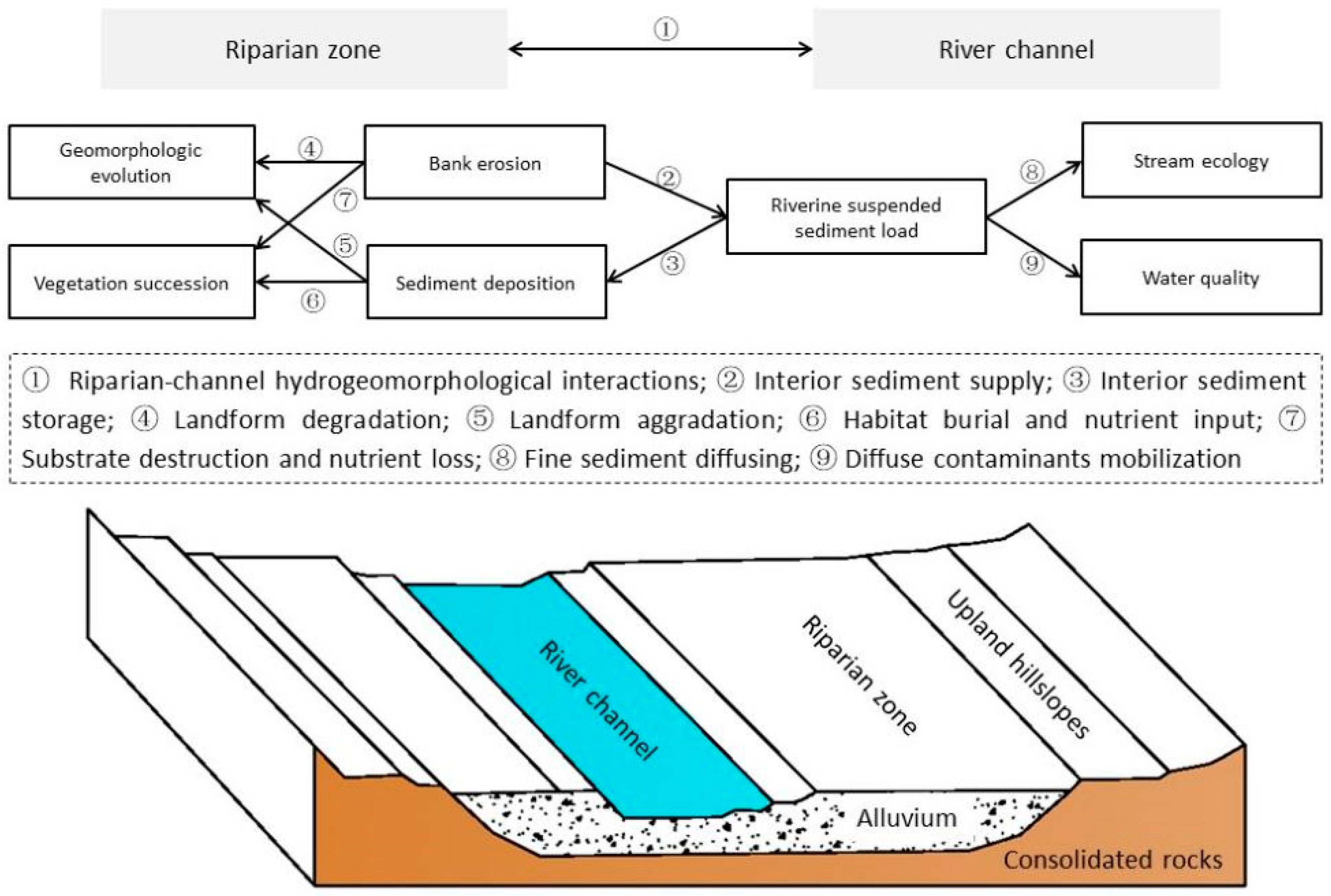
:1. Introduction
2. Methodology
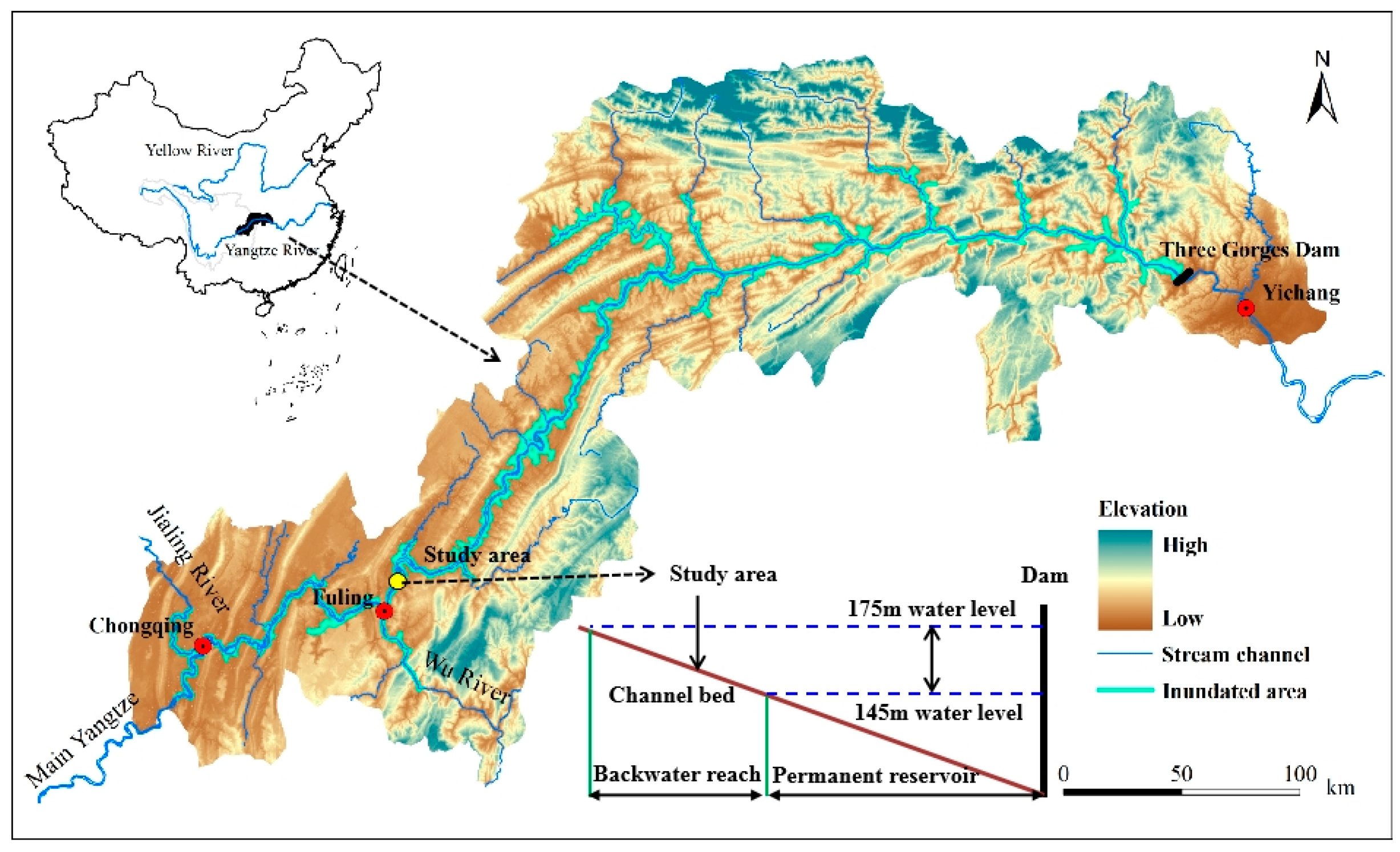
2.1. Study Area
2.2. Field Measurement
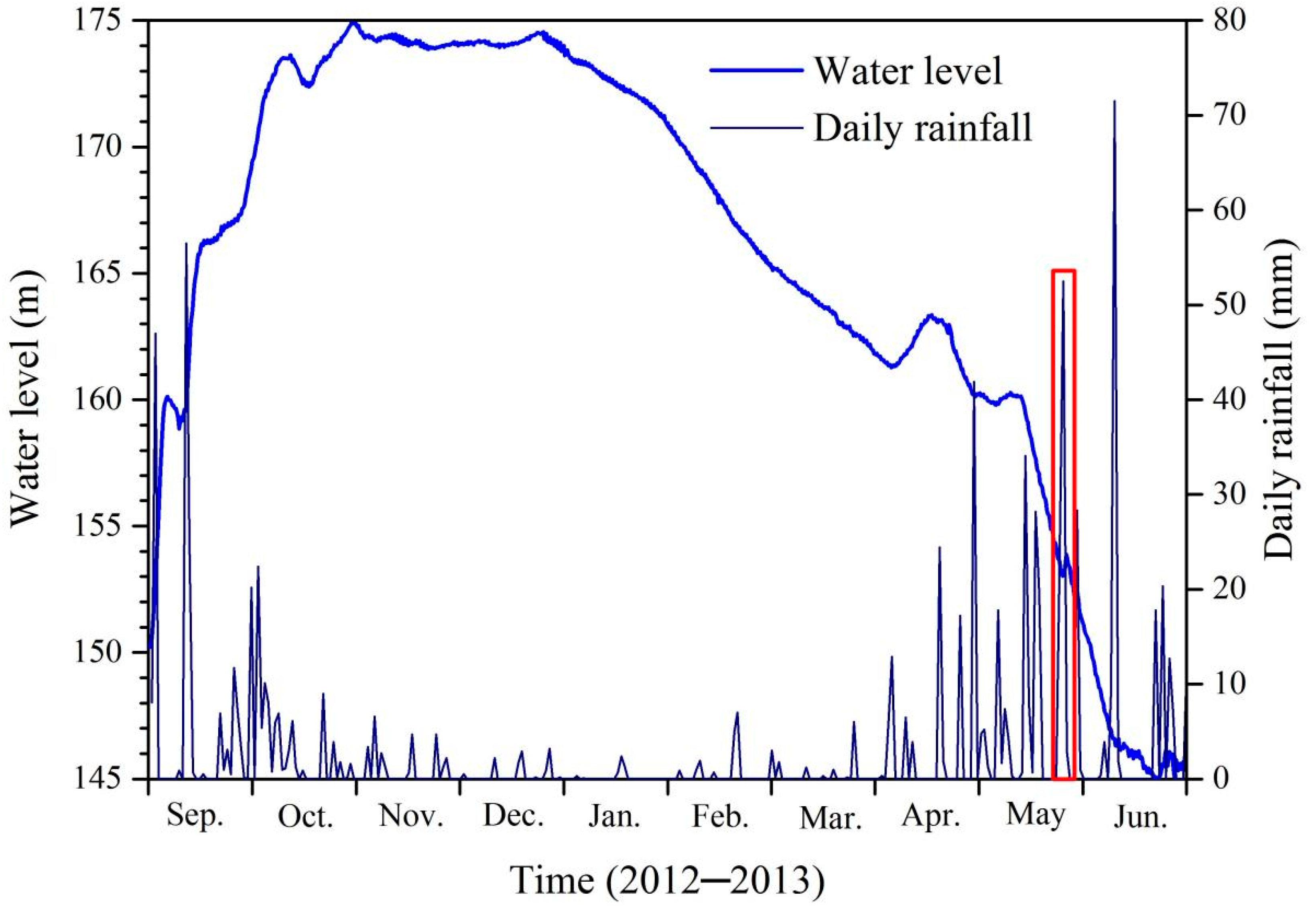
2.3. Data Acquisition
3. Results
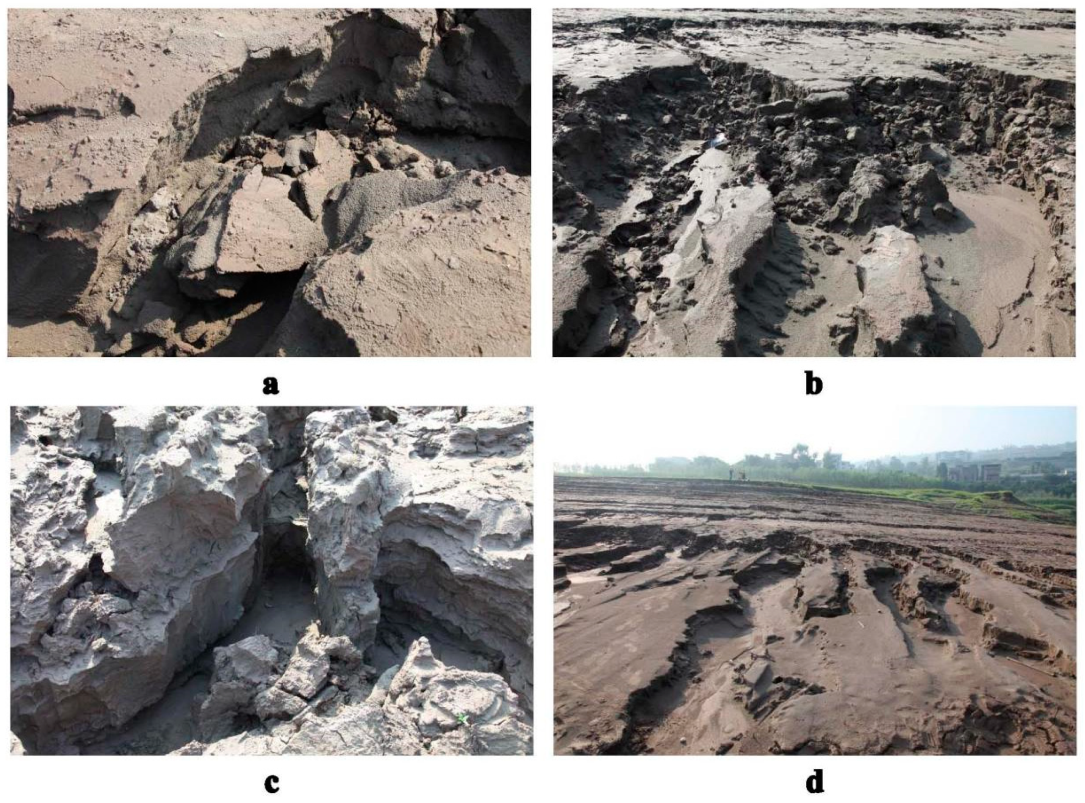
3.1. Morphologic Features of Soil Erosion in the Reservoir Riparian Zone
3.2. The Evolutionary Process of Bank Erosion in the Riparian Zone
3.3. Quantifying the Magnitude of Bank Erosion in the Riparian Zone
4. Discussion
4.1. The Specificity of Soil Erosion in This Reservoir Marginal Landscape
4.2. Geomorphological Role of Gully Erosion in Bank Erosion
5. Conclusions
Author Contributions
Funding
Institutional Review Board Statement
Informed Consent Statement
Data Availability Statement
Conflicts of Interest
References
- Hupp, C.R.; Osterkamp, W. Riparian vegetation and fluvial geomorphic processes. Geomorphology 1996, 14, 277–295. [Google Scholar] [CrossRef]
- Lane, S.N.; Tayefi, V.; Reid, S.C.; Yu, D.; Hardy, R.J. Interactions between sediment delivery, channel change, climate change and flood risk in a temperate upland environment. Earth Surf. Process. Landf. 2006, 32, 429–446. [Google Scholar] [CrossRef]
- Ta, W.; Jia, X.; Wang, H. Channel deposition induced by bank erosion in response to decreased flows in the sand-banked reach of the upstream Yellow River. Catena 2013, 105, 62–68. [Google Scholar] [CrossRef]
- Baniya, M.B.; Asaeda, T.; Fujino, T.; Jayasanka, S.M.D.H.; Muhetaer, G.; Li, J. Mechanism of Riparian Vegetation Growth and Sediment Transport Interaction in Floodplain: A Dynamic Riparian Vegetation Model (DRIPVEM) Approach. Water 2019, 12, 77. [Google Scholar] [CrossRef] [Green Version]
- Bull, L.J. Magnitude and variation in the contribution of bank erosion to the suspended sediment load of the River Severn, UK. Earth Surf. Proc. Land. 1997, 22, 1109–1123. [Google Scholar] [CrossRef]
- Florsheim, J.; Mount, J.F.; Chin, A. Bank Erosion as a Desirable Attribute of Rivers. BioScience 2008, 58, 519–529. [Google Scholar] [CrossRef]
- Walling, D.E.; Collins, A.L. Suspended sediment sources in British rivers. In Sediment Budgets 1, Proceedings of the Symposium S1 Held during the Seventh IAHS Scientific Assembly, Foz do Iguaçu, Brazil, 3–9 April 2005; Walling, D.E., Horowitz, A.J., Eds.; IAHS Press: Wallingford, UK, 2005. [Google Scholar]
- Kronvang, B.; Andersen, H.E.; Larsen, S.E.; Audet, J. Importance of bank erosion for sediment input, storage and export at the catchment scale. J. Soils Sediments 2012, 13, 230–241. [Google Scholar] [CrossRef]
- Owens, P.N.; Batalla, R.J.; Collins, A.J.; Gomez, B.; Hicks, D.M.; Horowitz, A.J.; Kondolf, G.M.; Marden, M.; Page, M.J.; Peacock, D.H.; et al. Fine-grained sediment in river systems: Environmental significance and management issues. River Res. Appl. 2005, 21, 693–717. [Google Scholar] [CrossRef]
- Stover, S.; Montgomery, D. Channel change and flooding, Skokomish River, Washington. J. Hydrol. 2001, 243, 272–286. [Google Scholar] [CrossRef]
- Dosskey, M.G.; Vidon, P.; Gurwick, N.P.; Allan, C.J.; Duval, T.P.; Lowrance, R. The Role of Riparian Vegetation in Protecting and Improving Chemical Water Quality in Streams. J. Am. Water Resour. Assoc. 2010, 46, 261–277. [Google Scholar] [CrossRef]
- Mander, Ü.; Hayakawa, Y.; Kuusemets, V. Purification processes, ecological functions, planning and design of riparian buffer zones in agricultural watersheds. Ecol. Eng. 2005, 24, 421–432. [Google Scholar] [CrossRef]
- Stutter, M.I.; Chardon, W.J.; Kronvang, B. Riparian Buffer Strips as a Multifunctional Management Tool in Agricultural Landscapes: In-troduction. J. Environ. Qual. 2012, 41, 297–303. [Google Scholar] [CrossRef] [PubMed] [Green Version]
- Osterkamp, W.R.; Hupp, C.R. Fluvial processes and vegetation—Glimpses of the past, the present, and perhaps the future. Geomorphology 2010, 116, 274–285. [Google Scholar] [CrossRef]
- Bao, Y.; Gao, P.; He, X. The water-level fluctuation zone of Three Gorges Reservoir—A unique geomorphological unit. Earth Sci. Rev. 2015, 150, 14–24. [Google Scholar] [CrossRef]
- Bao, Y.; Tang, Q.; He, X.; Hu, Y.; Zhang, X. Soil erosion in the riparian zone of the Three Gorges Reservoir, China. Hydrol. Res. 2013, 46, 212–221. [Google Scholar] [CrossRef]
- Fu, B.J.; Wu, B.F.; Lu, Y.H.; Xu, Z.H.; Cao, J.H.; Niu, D.; Yang, G.S.; Zhou, Y.M. Three Gorges Project: Efforts and challenges for the environment. Prog. Phys. Geog. 2010, 34, 741–754. [Google Scholar] [CrossRef]
- Zhang, Q.; Lou, Z. The environmental changes and mitigation actions in the Three Gorges Reservoir region, China. Environ. Sci. Policy 2011, 14, 1132–1138. [Google Scholar] [CrossRef]
- Tang, Q.; Bao, Y.H.; He, X.B.; Fu, B.J.; Collins, A.L.; Zhang, X.B. Flow regulation manipulates contemporary seasonal sedimentary dynamics in the reservoir fluctuation zone of the Three Gorges Reservoir, China. Sci. Total Environ. 2016, 548–549, 410–420. [Google Scholar] [CrossRef] [PubMed]
- Oparaku, L.A.; Iwar, R.T. Relationships between average gully depths and widths on geological sediments underlying the Idah-Ankpa Plateau of the North Central Nigeria. Int. Soil Water Conse. 2018, 6, 43–50. [Google Scholar] [CrossRef]
- Kaczmarek, H.; Mazaeva, O.; Kozyreva, E.; Babicheva, V.; Tyszkowski, S.; Rybchenko, A.A.; Brykała, D.; Bartczak, A.; Słowiński, M. Impact of large water level fluctuations on geomorphological processes and their interactions in the shore zone of a dam reservoir. J. Great Lakes Res. 2016, 42, 926–941. [Google Scholar] [CrossRef]
- Valentin, C.; Poesen, J.; Li, Y. Gully erosion impacts, factors and control. Catena 2005, 63, 132–153. [Google Scholar] [CrossRef]
- Zgłobicki, W.; Poesen, J.; Cohen, M.; Del Monte, M.; García-Ruiz, J.M.; Ionita, I.; Niacsu, L.; Machová, Z.; Martín-Duque, J.F.; Nadal-Romero, E.; et al. The Potential of Permanent Gullies in Europe as Geomorphosites. Geoheritage 2017, 11, 217–239. [Google Scholar] [CrossRef]
- Morgan, R.; Mngomezulu, D. Threshold conditions for initiation of valley-side gullies in the Middle Veld of Swaziland. Catena 2003, 50, 401–414. [Google Scholar] [CrossRef]
- Holbrook, J.; Schumm, S.A. Geomorphic and sedimentary response of rivers to tectonic deformation: A brief review and critique of a tool for recognizing subtle epeirogenic deformation in modern and ancient settings. Tectonophysics 1999, 305, 287–306. [Google Scholar] [CrossRef]
- Vandekerckhove, L.; Poesen, J.; Wijdenes, D.O.; Gyssels, G.; Beuselinck, L.; de Luna, E. Characteristics and controlling factors of bank gullies in two semi-arid mediterranean environments. Geomorphology 2000, 33, 37–58. [Google Scholar] [CrossRef]
- Brooks, A.P.; Shellberg, J.G.; Knight, J.; Spencer, J. Alluvial gully erosion: An example from the Mitchell fluvial megafan, Queensland, Australia. Earth Surf. Process. Landf. 2009, 34, 1951–1969. [Google Scholar] [CrossRef] [Green Version]
- Shellberg, J.G.; Spencer, J.; Brooks, A.P.; Pietsch, T.J. Degradation of the Mitchell River fluvial megafan by alluvial gully erosion in-creased by post-European land use change, Queensland, Australia. Geomorphology 2016, 266, 105–120. [Google Scholar] [CrossRef] [Green Version]
- Shellberg, J.; Brooks, A.; Spencer, J.; Ward, D. The hydrogeomorphic influences on alluvial gully erosion along the Mitchell River fluvial megafan. Hydrol. Process. 2012, 27, 1086–1104. [Google Scholar] [CrossRef]
- Erskine, W.D.; Melville, M.D. Sediment movement in a discontinuous gully system at Boro Creek, Southern Tablelands, N.S.W. In Drainage Basin Erosion and Sedimentation, Proceedings of the Conference on Erosion, Transportation and Sedimentation in Australian Drainage Basins, Newcastle, NSW, Australia, 14–17 May 1984; Loughran, R.J., Ed.; University of Newcastle and the Soil Conservation Service of N.S.W.: Newcastle, NSW, Australia, 1984. [Google Scholar]
- Yibeltal, M.; Tsunekawa, A.; Haregeweyn, N. Morphological characteristics and topographic thresholds of gullies in different agroecological environments. Geomorphology 2019, 341, 15–27. [Google Scholar] [CrossRef]
- Vandekerckhove, L.; Poesen, J.; Govers, G. Medium-term gully headcut retreat rates in Southeast Spain determined from aerial photographs and ground measurements. Catena 2003, 50, 329–352. [Google Scholar] [CrossRef]
- Capra, A.; Porto, P.; Scicolone, B. Relationships between rainfall characteristics and ephemeral gully erosion in a cultivated catchment in Sicily (Italy). Soil Tillage Res. 2009, 105, 77–87. [Google Scholar] [CrossRef]
- Li, Z.; Zhang, Y.; Zhu, Q.; He, Y.; Yao, W. Assessment of bank gully development and vegetation coverage on the Chinese Loess Plateau. Geomorphology 2015, 228, 462–469. [Google Scholar] [CrossRef]
- Castillo, C.; Gómez, J. A century of gully erosion research: Urgency, complexity and study approaches. Earth Sci. Rev. 2016, 160, 300–319. [Google Scholar] [CrossRef]
- Frankl, A.; Poesen, J.; Deckers, J.; Haile, M.; Nyssen, J. Gully head retreat rates in the semi-arid highlands of Northern Ethiopia. Geomorphology 2012, 173–174, 185–195. [Google Scholar] [CrossRef] [Green Version]
- Frankl, A.; Poesen, J.; Haile, M.; Deckers, J.; Nyssen, J. Quantifying long-term changes in gully networks and volumes in dryland envi-ronments: The case of Northern Ethiopia. Geomorphology 2013, 201, 254–263. [Google Scholar] [CrossRef] [Green Version]
- Zucca, C.; Canu, A.; Della Peruta, R. Effects of land use and landscape on spatial distribution and morphological features of gullies in an agropastoral area in Sardinia (Italy). Catena 2006, 68, 87–95. [Google Scholar] [CrossRef]
- Wu, H.; Xu, X.; Zheng, F.; Qin, C.; He, X. Gully morphological characteristics in the loess hilly-gully region based on 3D laser scanning technique. Earth Surf. Process. Landf. 2018, 43, 1701–1710. [Google Scholar] [CrossRef]
- Montgomery, D.; Dietrich, W. Where do channels begin? Nature 1988, 336, 232–234. [Google Scholar] [CrossRef]
- Prosser, I.P.; Chappell, J.; Gillespie, R. Holocene valley aggradation and gully erosion in headwater catchments, south-eastern highlands of Australia. Earth Surf. Process. Landf. 1994, 19, 465–480. [Google Scholar] [CrossRef]
- Knapen, A.; Poesen, J.; Govers, G.; Gyssels, G.; Nachtergaele, J. Resistance of soils to concentrated flow erosion: A review. Earth Sci. Rev. 2007, 80, 75–109. [Google Scholar] [CrossRef]
- Montgomery, D.R.; Dietrich, W.E. Channel Initiation and the Problem of Landscape Scale. Science 1992, 255, 826–830. [Google Scholar] [CrossRef] [Green Version]
- Oostwoud Wijdenes, D.; Bryan, R. Gully-head erosion processes on a semi-arid valley floor in Kenya: A case study into temporal varia-tion and sediment budgeting. Earth Surf. Proc. Land. 2001, 26, 911–933. [Google Scholar] [CrossRef]
- Mazaeva, O.; Babicheva, V.; Kozyreva, E. Gully development on large dam reservoir shores: Dynamics, interaction, and mechanisms. Phys. Geogr. 2019, 41, 195–216. [Google Scholar] [CrossRef]
- Poesen, J.; Nachtergaele, J.; Verstraeten, G.; Valentin, C. Gully erosion and environmental change: Importance and research needs. Catena 2003, 50, 91–133. [Google Scholar] [CrossRef]
- Collins, B.D.; Sitar, N. Processes of coastal bluff erosion in weakly lithified sands, Pacifica, California, USA. Geomorphology 2008, 97, 483–501. [Google Scholar] [CrossRef]
- Vilmundardóttir, O.; Magnússon, B.; Gísladóttir, G.; Thorsteinsson, T. Shoreline erosion and aeolian deposition along a recently formed hydro-electric reservoir, Blöndulón, Iceland. Geomorphology 2010, 114, 542–555. [Google Scholar] [CrossRef]
- Burkard, M.B.; Kostaschuk, R.A. Patterns and controls of gully growth along the shoreline of Lake Huron. Earth Surf. Process. Landf. 1997, 22, 901–911. [Google Scholar] [CrossRef]
- Mazaeva, O.; Pellinen, V.; Janicki, G. Development of bank gullies on the shore zone of the Bratsk Reservoir (Russia). Ann. UMCS Geogr. Geol. Miner. Petrogr. 2014, 69, 117–133. [Google Scholar] [CrossRef] [Green Version]
- Smolska, E. Development of gullies and sedimentjans in last-glacial areas on the example of the Suwalki Lakeland (NE Poland). Catena 2007, 71, 122–131. [Google Scholar] [CrossRef]
- Leyland, J.; Darby, S.E. An empirical–conceptual gully evolution model for channelled sea cliffs. Geomorphology 2008, 102, 419–434. [Google Scholar] [CrossRef] [Green Version]
- Schumm, S.A.; Hadley, R.F. Arroyos and the semiarid cycle of erosion [Wyoming and New Mexico]. Am. J. Sci. 1957, 255, 161–174. [Google Scholar] [CrossRef]
- Tucker, G.E.; Arnold, L.; Bras, R.L.; Flores, H.; Istanbulluoglu, E.; Sólyom, P. Headwater channel dynamics in semiarid rangelands, Colorado high plains, USA. Geol. Soc. Am. Bull. 2006, 118, 959–974. [Google Scholar] [CrossRef]
- Schumm, S.A.; Lichty, R.W. Space, time and causality in geomorphology. Am. J. Sci. 1965, 263, 110–119. [Google Scholar] [CrossRef]
- Phillips, J.D. Relative importance of intrinsic, extrinsic, and anthropic factors in the geomorphic zonation of the Trinity River, Texas. J. Am. Water Resour. Assoc. 2010, 46, 807–823. [Google Scholar]


| Morphologic Features | Number | Lengths (m) | Widths (m) | Depths (m) |
|---|---|---|---|---|
| Continuous gullies | 2 | 38–46 | 0.2–0.8 | 0.3–1.9 |
| Discontinuous gullies | 6 | 3.1–3.8 | 0.4–1.6 | 0.1–0.4 |
| Map Area (m2) | Surface Area (m2) | Gully Length (m) | Mean W (m) | Mean D (m) | W/D | Gradient (%) | Eroded Volume (m3) |
|---|---|---|---|---|---|---|---|
| 25 | 1.36 | 2.37 | 0.45 | 0.12 | 3.75 | 16.30 | 0.096 |
| 2.67 | 3.88 | 0.62 | 0.21 | 2.95 | 16.80 | 0.21 | |
| 1.35 | 3.45 | 0.30 | 0.10 | 3.00 | 16.20 | 0.085 | |
| 2.65 | 3.90 | 0.62 | 0.20 | 3.10 | 16.40 | 0.20 | |
| 2.36 | 3.85 | 0.55 | 0.15 | 3.67 | 16.30 | 0.16 | |
| 2.85 | 3.95 | 0.68 | 0.20 | 3.40 | 16.60 | 0.26 | |
| Total | 13.24 | 21.40 | 0.54 | 0.16 | 3.31 | 16.43 | 1.01 |
| Forms | Processes | Agents | Water Level |
|---|---|---|---|
| Gully | Raindrop detachment, scouring, micro-scale mass failure | Raindrops, overland flows, stream waves | Higher water level or water level fluctuation |
| Inter-gully | Sheeting | Stream waves, runoff | Higher water level and low water level |
Publisher’s Note: MDPI stays neutral with regard to jurisdictional claims in published maps and institutional affiliations. |
© 2021 by the authors. Licensee MDPI, Basel, Switzerland. This article is an open access article distributed under the terms and conditions of the Creative Commons Attribution (CC BY) license (https://creativecommons.org/licenses/by/4.0/).
Share and Cite
Bao, Y.; Yu, Y.; Tang, Q.; He, X.; Wei, J.; Hu, Y.; Li, J. Combined Effects of Hillslope-Concentrated Flows and Riverine Stream Waves on Soil Erosion in the Reservoir Riparian Zone. Water 2021, 13, 3465. https://0-doi-org.brum.beds.ac.uk/10.3390/w13233465
Bao Y, Yu Y, Tang Q, He X, Wei J, Hu Y, Li J. Combined Effects of Hillslope-Concentrated Flows and Riverine Stream Waves on Soil Erosion in the Reservoir Riparian Zone. Water. 2021; 13(23):3465. https://0-doi-org.brum.beds.ac.uk/10.3390/w13233465
Chicago/Turabian StyleBao, Yuhai, Yantong Yu, Qiang Tang, Xiubin He, Jie Wei, Yunhua Hu, and Jinlin Li. 2021. "Combined Effects of Hillslope-Concentrated Flows and Riverine Stream Waves on Soil Erosion in the Reservoir Riparian Zone" Water 13, no. 23: 3465. https://0-doi-org.brum.beds.ac.uk/10.3390/w13233465