

Integrating Machine Learning in Urban Pedagogy: Addressing Homelessness in Skid Row


College of Architecture and Environmental Design, Kent State University, Kent, OH 44240, USA
Architecture 2024, 4(1), 112-123; https://0-doi-org.brum.beds.ac.uk/10.3390/architecture4010008
Submission received: 18 December 2023
/
Revised: 30 January 2024
/
Accepted: 5 February 2024
/
Published: 15 February 2024
(This article belongs to the Special Issue Interdisciplinary and Multi-Scalar Design and Research Models in Architectural Practice and Education)
Abstract
:This paper investigates the application of machine learning in urban and architectural education, with a focus on addressing homelessness in Skid Row, Los Angeles. It presents a case study of an urban design studio utilizing data-driven methods to propose transitional housing solutions, emphasizing the importance of design in the context of social justice. The study explores the use of machine learning and digital cartography for a detailed analysis of Skid Row’s dense homeless population, offering students a thorough insight into urban challenges. The research also identifies the complexities involved in integrating these technologies into educational frameworks, including issues with data accuracy, technical hurdles, and ethical considerations. The paper concludes by advocating for an interdisciplinary, data-informed, and socially conscious approach in architectural and urban design education, highlighting its necessity in preparing students to effectively tackle contemporary urban problems.
Keywords:
machine learning; urban design; architecture; pedagogy; homelessness; Skid Row; Los Angeles1. Introduction
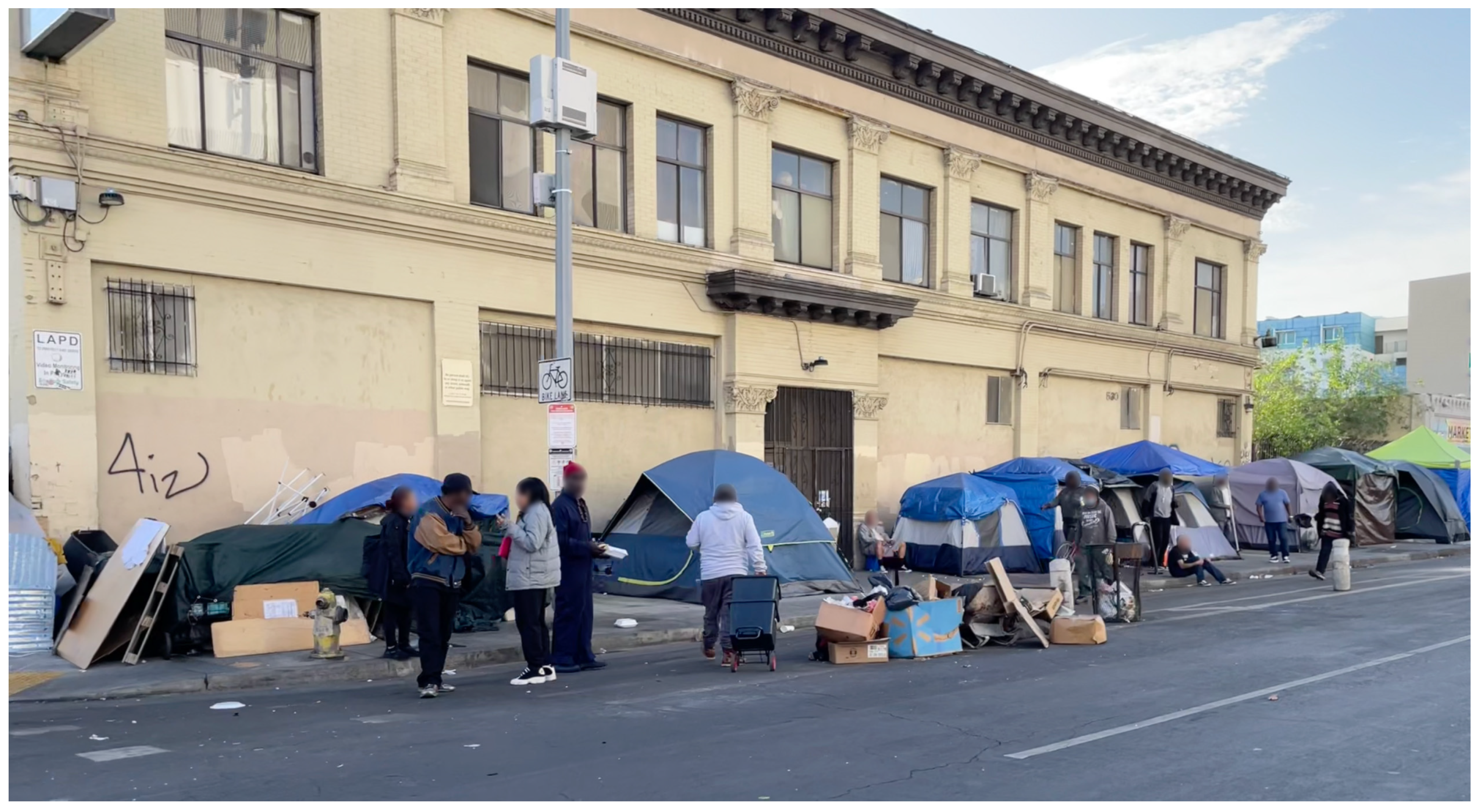
Los Angeles is at the forefront of America’s homelessness crisis, a challenge starkly illustrated by the 2023 Greater Los Angeles Homeless Count. This count identified approximately 75,518 individuals experiencing homelessness across LA County on any given night, with 46,260 of those in LA City alone [1]. In the midst of this crisis is Skid Row, a 50-block area in downtown Los Angeles, which epitomizes the urban homelessness challenge. Home to approximately 4402 sheltered and unsheltered homeless populations, Skid Row serves as a striking representation of the intense density and complexity of homelessness in urban America [2] (Figure 1). This research paper delves into the multifaceted nature of Skid Row’s homelessness, examining the role of innovative, data-driven approaches in urban design education and policy making, particularly focusing on machine learning’s potential in shaping strategies to address this crisis.
Central to understanding Skid Row’s current state is the historical and policy-driven factors that have shaped it. Exclusionary zoning practices, common across many urban centers, have historically concentrated homelessness in specific areas, with Skid Row being a prime example [3]. Over time, Skid Row has evolved into a neighborhood of last resort, marked by an array of cheap, single-room occupancy (SRO) hotels and a concentration of social services. This development has made it a refuge for individuals grappling with extreme poverty, disability, mental illness, and addiction [4]. The 2023 homeless count, highlighting the prevalence of makeshift shelters and vehicles as homes, underlines the enduring challenge of providing adequate and stable housing in this area [1].
The attempts to ‘clean up’ Skid Row since the 1980s have often exacerbated the plight of its homeless residents. Efforts to redevelop the area and implement intensive policing strategies have frequently resulted in the displacement of homeless populations without substantially decreasing the overall number of homeless individuals [5,6,7]. This has led to a complicated and often contested landscape, where the goals of urban development and real estate interests clash with the basic needs and rights of the homeless population.
Amidst this complex scenario, grassroots organizations, particularly the Los Angeles Community Action Network, have emerged as vocal advocates for the rights of Skid Row’s homeless residents. These organizations have been instrumental in opposing measures that undermine the welfare of homeless people and have actively championed legal initiatives to safeguard their interests [5,8]. Their efforts highlight the importance of community-led resistance in shaping policies and practices around urban homelessness.
In light of this backdrop, the relevance of incorporating data-driven methods such as machine learning into urban design education becomes increasingly clear. By understanding and addressing the complexities of areas like Skid Row, urban design studios can encourage students to integrate these advanced technologies into their work. This is particularly pertinent in developing transitional housing concepts for communities such as those in Skid Row. The integration of machine learning and other advanced technologies into urban design education serves a dual purpose: it enriches the students’ understanding of multifaceted urban challenges and equips them with the skills necessary for data-driven decision making in their future careers. The anticipated use of sophisticated digital tools, including the automation of satellite imagery and the TensorFlow Object Detection API, bridges the gap between traditional design practices and cutting-edge technology. This synthesis not only aligns with the interdisciplinary nature of modern urban challenges, but also underscores the importance of technological fluency for future urban designers and architects. In doing so, it opens up avenues for these professionals to engage more effectively with the issues highlighted by grassroots organizations, potentially leading to more informed and equitable solutions for longstanding urban challenges like homelessness.
2. Methodology
This paper presents a methodological exploration of the integration of machine learning within the domain of urban design and architectural education. Initially, it delves into existing urban pedagogies, highlighting participatory urban design, experiential community-engaged learning, and interdisciplinary studio approaches. These traditional methods underscore the importance of hands-on, real-world engagement and collaborative problem solving in urban contexts.
Emerging methodologies are then introduced, focusing on the use of diverse data sources such as satellite imagery, CCTV footage, and social media content to enrich urban analysis. These innovative approaches mark a significant shift in architectural education, offering a more nuanced and detailed perspective on urban landscapes. For instance, satellite imagery provides a macroscopic view of urban sprawl and development patterns, while CCTV footage offers insights into micro-level urban dynamics such as traffic flow and pedestrian movement. Social media content, on the other hand, serves as a reflection of public perception and interaction with urban spaces.
Following this exploration, the paper transitions to a case study in an urban design class. Here, the application of machine learning is exemplified in the context of analyzing homelessness in Skid Row, Los Angeles. This case study demonstrates how integrating data-driven methods can offer profound insights into complex urban issues, aiding in the development of more informed and effective urban design strategies. By combining traditional pedagogical approaches with these emerging methodologies, the study highlights the evolving landscape of urban and architectural education, emphasizing the importance of equipping future professionals with the skills to navigate and address the multifaceted challenges of urban environments.
3. Urban Pedagogy and Data-Driven Approaches
Urban design pedagogy is evolving to incorporate more real-world, community-engaged, and technologically enabled learning experiences. The recent literature highlights pedagogical innovations in studios and courses that address local community needs through participatory planning and design. Participatory urban pedagogy, which involves students in real-world community projects, offers a profound experiential learning experience. This method allows students to directly confront complex urban challenges and diverse community requirements, honing essential skills such as problem solving, communication, and empathy, and the ability to reconcile different viewpoints. For example, Michael Neuman’s work illustrates the effectiveness of a collaborative, interdisciplinary studio approach in education, where the involvement of students in practical, service-based projects is emphasized [9]. This methodology, demonstrated in a project focused on Palacios, integrates students, faculty, and clients in tackling real-world issues, from urban redevelopment to regional planning.
In the evolving landscape of urban design pedagogy, addressing problems with a focus on social justice is of considerable importance. This academic approach involves instilling in students an understanding of the impacts of urban design on diverse social groups, especially the marginalized and underserved. Emphasizing issues like housing affordability and equitable access to public amenities, this pedagogy aims to equip future urban designers with the skills to identify and address systemic biases. Such a curriculum is crucial in developing professionals capable of creating urban environments that are not only innovative, but also deeply rooted in social equity and inclusivity. For instance, Loukaitou-Sideris and Mukhija employ participatory mapping and visualization in a studio addressing informal settlements, reflecting on effective pedagogical approaches when collaborating with marginalized communities [10].
On the other hand, interactive and visual technologies in urban design education provide new opportunities for experiential learning. In urban design, Augmented Reality (AR) and Virtual Reality (VR) serve as powerful tools, enabling immersive previews of proposed projects. With AR, digital enhancements are superimposed onto actual environments, aiding in visualizing and planning within real-world contexts. Meanwhile, VR provides a complete immersive experience, allowing users to explore future developments virtually, thus improving both decision-making processes and stakeholder engagement. In line with these advancements, Speranza demonstrates the use of parametric urban modeling to help students grasp the complexities of urban characters [11]. This method blends traditional design principles with advanced computational techniques, offering a nuanced approach to urban design education. Similarly, Lim et al. provide a comprehensive review of digital methods in urban design, highlighting how these technologies enable new ways of experiencing and learning about cities [12]. Their work emphasizes the use of digital media for research that engages with oral, visual, and sensory experiences, further enhancing design communication skills through tools such as video, animation, and interactive PDFs. These approaches collectively bring new perspectives to traditional urban design concepts, showcasing the evolving landscape of urban design education. In addition to these methods, Ameijde et al. emphasize the role of information and communication technologies (ICTs) in relation to studio design education and report on an innovative pedagogical initiative which introduces data-driven methods to academic teaching practices [13].
While the existing literature on urban design pedagogy has largely focused on community participation and mainly interactive and visual technologies, there is an emerging need to discuss how big data and machine learning can revolutionize this field. The exponential growth in urban datasets, both in size and complexity, calls for new computational methods to analyze and derive insights, offering alternative strategies to traditional top-down planning, as suggested by Batty [14]. Machine learning, in particular, provides data-driven ways to identify patterns, model complex urban systems, and potentially automate aspects of design and planning, as noted by Carta [15].
Integrating these technologies into urban design education through the analysis of real-world urban datasets is crucial for developing skills suited to data-intensive planning and design practices. Urban design curricula should evolve to include more opportunities for students to engage with big data, which will necessitate learning basic data science and programming skills. Furthermore, advanced educational programs, such as doctoral and graduate courses, should offer specialized training in machine learning applications for urban design and planning.
This evolution in pedagogy is not just about integrating new technologies, it is about preparing a new generation of urban designers and planners who are not only technologically proficient, but also socially conscious. The combination of community participation with big data analytics and machine learning will enable these future professionals to engage in evidence-based design and planning, creating urban spaces that are both innovative and equitable. Therefore, it is essential for contemporary urban design education to embrace this blend of community engagement, social justice, and advanced technological methodologies, fostering an interdisciplinary approach to urban development.
4. Emerging Methodologies in Urban Analysis
The study of urban environments is evolving significantly with the incorporation of advanced technologies such as machine learning into architectural and urban design education. This evolution is characterized by an increased use of diverse data sources. These cutting-edge methods offer a novel lens for understanding and analyzing urban landscapes, enabling a more detailed and multifaceted perspective. Delving into these varied technologies enhances the pedagogical framework, equipping students with the essential skills to decipher and navigate the complexities of urban settings. Such integration not only enriches the educational curriculum, but also prepares future professionals to tackle the diverse challenges of contemporary urban planning and design.
One particular study utilizes the integration of deep-neural-network-based approaches for urban analysis. The research conducted by a team of scholars, including Cao et al., combined aerial and street-level imagery in a novel way to enhance the precision of urban land use classification [16]. Their work innovatively synthesized aerial imagery with street view data, thereby enhancing the accuracy and depth of urban land use analysis. Their comprehensive study meticulously captured the complexities and subtleties inherent within urban landscapes, offering a panoramic perspective that transcends conventional methodologies. This advanced approach emerges as an invaluable asset within the urban and architectural pedagogical sphere, equipping students with a sophisticated analytical tool to dissect and interpret the layered dynamics of urban environments.
In a similar vein of utilizing advanced imaging for urban analytics, semantic segmentation’s pivotal role is skillfully demonstrated in student work from the Stuart Weitzman School of Design at University of Pennsylvania, focusing on land-use classification in 2023. The students’ project presents semantic segmentation as a precise tool for categorizing various types of land uses. This cutting-edge approach aids educators in imparting a deep and nuanced comprehension of urban form and structure to their students. The work provides an explorative narrative on the complex relationship between the built environment and land utilization, granting students an integrated perspective of urban landscapes and their evolving patterns [17].
Shifting the focus to a different aspect of urban design, the study conducted by Rezaei et al. explores the application of CCTV footage for 3D traffic monitoring using a single camera [18]. Their work delves into the advancements in object detection algorithms and tracking methodologies, which facilitate an exhaustive analysis of traffic patterns. Such insights can be invaluable for urban design and planning classes, providing a detailed investigation into urban traffic behaviors and their implications for urban planning and architectural designs. This understanding further contributes to the broader discussion on sustainable urban development, wherein traffic management emerges as a crucial consideration [18].
In a separate yet technologically innovative exploration, Algiriyage et al. discuss the utilization of advanced algorithms for analyzing traffic data from surveillance video footage [19]. Their study offers students insights into real-time urban dynamics, highlighting the potential of modern technologies in traffic flow estimation. This aspect is crucial for urban planning and development, emphasizing the potential of leveraging cutting-edge technology to address urban challenges and enrich the academic curriculum with practical, real-world applications [19].
Exploring another technological advancement, drones, as discussed in the article by Hannah Wood, provide a unique perspective for urban data collection. Their capabilities extend from construction monitoring to nuanced site analysis, offering a plethora of new opportunities for architects and urban planners. The narrative elucidates the myriad ways in which drone technology is revolutionizing the architectural domain, enabling a more nuanced understanding and analysis of urban landscapes [20]. The incorporation of drone technology in educational modules can equip students with practical exposure to modern data collection methodologies, nurturing skills that are becoming increasingly pertinent in this domain.
Similarly, the role of street-view imagery in urban analytics, as examined by Biljecki and Ito, underscores the importance of visual data in urban analysis and geographic information systems [21]. In addition to traditional street-view data, platforms like Mapillary and KartaView offer a rich repository of user-generated street-level imagery. Mapillary, for instance, employs a collaborative platform where individuals contribute imagery data, which are then made accessible for various urban analysis tasks. Similarly, KartaView provides an open platform for sharing and utilizing street-level photos for a multitude of applications, including urban planning and analysis. These platforms are emblematic of the burgeoning trend of crowdsourced data collection, which not only democratizes data, but also significantly broadens the scope and depth of available imagery for urban analytics. By engaging with such platforms, students can gain a hands-on understanding of contemporary data collection methodologies, further enhancing their comprehension of urban locales and their complex dynamics [21].
Lastly, the emergence of social media imagery as a fresh data source for grasping urban spaces is exemplified in the ASLA’s 2019 case study on Seattle Freeway Park. This case underscores how social media platforms can mirror the public engagement with and perception of urban environments, providing a unique lens through which students can examine the human facet embedded in urban and architectural analysis. It highlights the transformative potential of leveraging social media data in understanding and enhancing public spaces, thus enriching the academic discourse on urban design and planning [22].
While the comparative analysis highlights the distinct values of each data source, it is evident that all contribute uniquely to a better understanding of urban spaces. As demonstrated, numerous scholars have effectively utilized these data sources in conjunction with machine learning to enrich urban studies. Incorporating diverse data sources and methodologies into urban and architectural education significantly enhances the curriculum, transcending traditional teaching paradigms (Table 1). This integration equips students to adeptly address the complex aspects of contemporary urban planning and design. Through an in-depth exploration of both the physical and social dimensions of urban environments, students develop a sophisticated understanding of the interplay between architectural forms, their functions, and human experiences. Such a comprehensive perspective is not only vital for confronting challenges in urban contexts, but also lays the groundwork for applying these approaches in practical scenarios. Reflecting on this, the following section will touch upon a studio at the College of Architecture & Environmental Design at Kent State University, where we specifically chose aerial imagery to address the critical issue of homelessness, owing to its accessibility and the breadth of data it provides.
5. Digital Cartography and Machine Learning
The exploration of transitional housing and the intricacies of homelessness in urban settings are pivotal facets of architectural education and practice, particularly as they pertain to areas with dense instances of homelessness, such as Skid Row in Los Angeles. Our traveling urban design studio engaged in a longitudinal study focusing on this region, with an aim to contribute substantive analysis and solutions to the chronic issue of homelessness.
During two distinct studio sessions, students engaged in a thorough and detailed examination of the Skid Row landscape, employing a comprehensive analytical approach. Initially, their investigation encompassed an extensive study of housing and homelessness policies, police raids, and the resources available to the unsheltered population over a decade. This preliminary research provided a critical context for understanding the dynamics at play in urban homelessness.
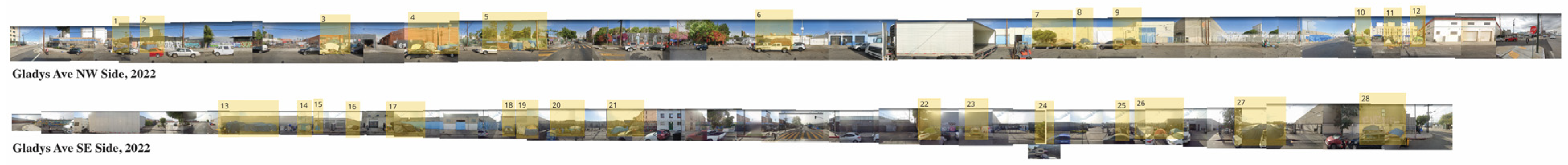
Following this foundational analysis, the focus shifted to a methodological examination revolving around the quantification and location of tents on sidewalks—a stark, visible indicator of homelessness. In the initial studio segment, students manually collected data using Google Maps Satellite View and Google Street View. They identified tents on assigned streets, cross-checked their locations for accuracy between the satellite and street views, and recorded the coordinates of each tent in a spreadsheet. This detailed process, while time-consuming, ensured the precision of the data. The outcome of this task was a comprehensive spreadsheet mapping the distribution of homeless encampments (Figure 2).
This pedagogical approach was adopted to address key questions: identifying urban locations predominantly favored by the homeless, understanding how these preferences have evolved over time, and unraveling the reasons behind these patterns, be it the urban physical fabric, availability of resources, or other factors.
The comprehensive tableau of Skid Row’s homelessness that emerged from this study, while enlightening, also presented its challenges. The task’s detail-oriented nature deepened students’ understanding of urban homelessness through a data-driven approach, enhancing their skills in site selection and providing them with a more comprehensive historical perspective on space utilization. Mapping tent clusters revealed transient yet resilient patterns of homeless communities, providing rich insights into urban dynamics. However, the extensive manual data collection underscored the need for more efficient methodologies in urban studies, highlighting the practical challenges in analyzing complex urban phenomena.
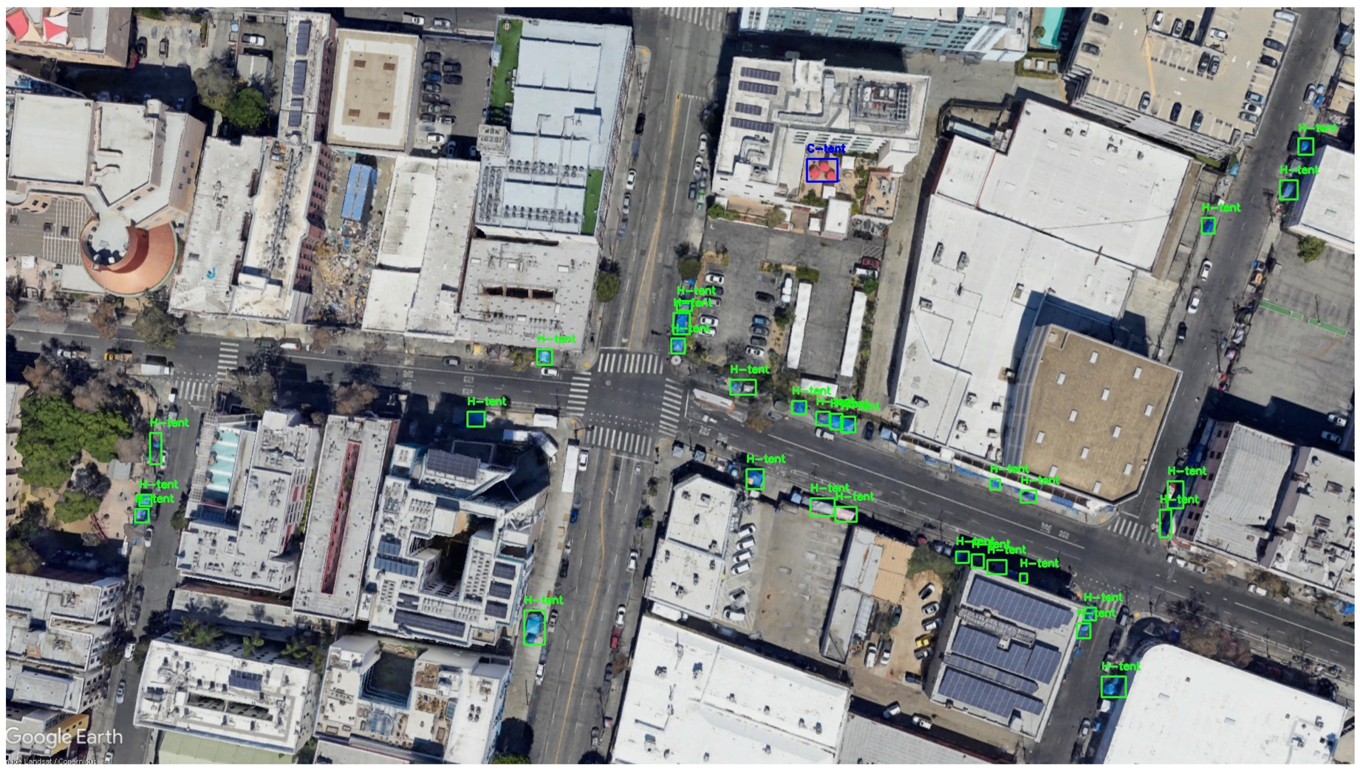
In response to these challenges, there was a shift towards incorporating advanced digital tools, reflecting the growing accessibility of such technologies. This approach leveraged automated processes for satellite image acquisition, involving a script that captured and labeled images based on coordinates for object detection. The TensorFlow Object Detection API (version 2.13.0) was utilized, specifically the SSD MobileNet V1 FPN 640 × 640 model, chosen for its balance of speed, accuracy, and our computational capacity. The quality of the satellite images was a crucial factor, as images with a lower quality hindered accurate tent detection.
Initially, satellite imagery of high fidelity was harvested, dating back a decade to 2013, to discern temporal patterns in the proliferation of homeless encampments. Subsequently, we engaged in the rigors of machine learning, meticulously training and testing a detection model to identify and categorize tents. This nuanced process distinguished between tents utilized by the homeless, predominantly situated on public pavements, and other tent structures located on private grounds or atop buildings (Figure 3).
With a refined model, we processed extensive maps encompassing Skid Row, extracting tent coordinates to construct a dynamic visual narrative of the decade’s spatial transformations. This digital cartography serves not only as a historical record, but also as a basis for correlative analysis with ancillary data streams—such as the evolution of municipal resources for the homeless, the enforcement of urban policies, and their spatial ramifications.
The incorporation of digital mapping and object detection technologies marks a significant evolution in design studio methodologies. In the past, conducting such detailed analyses required either extensive time commitments or specialized technical skills. Now, with the advent of these advanced technologies, this process has become more accessible, providing a comprehensive dataset that enhances scholarly research.
This development has profound implications for architectural education. It enables students to underpin their design proposals with empirical data, effectively bridging the gap between abstract theoretical concepts and the concrete realities of urban social issues. The integration of these digital tools into architectural pedagogy is emblematic of a broader shift. It highlights the transformative impact these technologies can have in redefining design practices at multiple levels, from material innovation to critical urban interventions. By leveraging these tools, students gain a deeper understanding of the complexities of urban environments, fostering a more informed and responsive approach to architectural design.
6. Limitations in the Integration of Machine Learning in Architecture and Urban Design Teaching
The incorporation of machine learning into the teaching of architecture and urban design signifies a major leap forward in educational practices. However, it is essential to recognize that this innovative approach comes with its own set of limitations and challenges. Moreover, we recognize the significant efforts of specialized scientific communities in addressing a spectrum of challenges inherent to AI/ML, encompassing issues like data quality and accuracy, the complexity of machine learning models, ensuring sufficient computing power, and navigating the critical aspects of ethics and privacy. This manuscript examines a selection of these challenges, particularly relevant to the incorporation of such technologies in architecture and urban design education, but it is by no means an exhaustive exploration of the extensive work conducted by these communities. Despite the considerable advantages it offers in terms of deepening learning experiences and expanding analytical capacities, there are inherent constraints and difficulties that need to be carefully considered. These limitations play a crucial role in shaping the overall effectiveness and applicability of machine learning technologies in the context of architectural and urban design education.
6.1. Data Quality and Accuracy Concerns
A primary limitation lies in the quality and accuracy of the data sources utilized. Aerial imagery, street-view data, and social media imagery, while invaluable, are prone to inaccuracies and inconsistencies. The reliance on these data sources for urban analysis introduces a risk of erroneous or misleading outcomes. Inaccuracies can lead to a skewed understanding of urban landscapes, affecting both the learning process and the eventual practical application of this knowledge.
6.2. Complexity of Machine Learning Models
The intricacy of machine learning models presents a considerable challenge, particularly for those new to the fields of architecture and urban planning. These beginners often face a steep learning curve when attempting to understand and apply these complex models. Machine learning, with its intricate algorithms and technical subtleties, requires substantial expertise, especially in computational sciences. For students and professionals in urban design and architecture who may not have an extensive background in these areas, accurately implementing and utilizing these tools can be daunting. This level of complexity not only poses a barrier to entry, but could also impede the widespread adoption and effective integration of machine learning in architectural education, underscoring the need for tailored educational strategies and interdisciplinary support.
6.3. Access to Computing Power
In the realm of architecture and urban design education, the effective integration of machine learning is deeply influenced by the availability of sufficient computing resources. Teaching advanced models necessitates high-end GPUs, yet limitations in speed and data handling are prevalent, even with powerful hardware. Constraints in RAM and CPU speed pose significant bottlenecks in both the training and application of ML models in the classroom. This scenario is analogous to challenges faced in deploying ML models in resource-limited environments, such as the Europa Clipper spacecraft project, where computational resource scarcity necessitated the use of less demanding ML techniques [23]. Moreover, the environmental impact of training ML models, with its substantial energy and greenhouse gas footprint, presents an additional layer of complexity, emphasizing the need for teaching computationally efficient practices.
6.4. Ethical and Privacy Concerns
Additionally, the use of public and user-generated data, such as CCTV footage and social media content, raises ethical and privacy concerns. The balance between leveraging such data for urban analytics and respecting individual privacy rights is delicate. There is a risk of inadvertently infringing upon personal privacy or misusing data, which can lead to ethical dilemmas and potential legal implications. This aspect of data usage necessitates careful consideration and responsible management, especially in an educational context where students are learning the foundations of ethical professional practice. Furthermore, the increased delegation of functions to algorithms, often at the expense of human control, amplifies concerns for loss of fairness and equitability, as well as the potential emergence of ‘garbage-in-garbage-out’ issues in contexts where external control is limited [24,25].
While the incorporation of machine learning into architectural and urban design education offers exciting prospects for enhanced learning and sophisticated analysis, it is not without its challenges. Concerns regarding data quality, the complexity of machine learning models, access to computing power, and ethical considerations represent significant barriers. These limitations must be carefully navigated to ensure that the integration of these advanced technologies into educational curriculums is both effective and responsible. Furthermore, one effective way to overcome these limitations is through interdisciplinary collaboration, particularly with computer science departments, leveraging the expertise of faculty and students who are already well-versed in AI/ML methodologies. This approach is ultimately fostering a generation of architects and urban planners who are well-equipped to utilize technology ethically and effectively in their future professional endeavors.
7. Discussion
In the field of architectural and urban design education, especially when tackling complex urban issues like homelessness, the shift towards data-driven methods represents a significant development. This is illustrated in the urban design studio’s study of Skid Row in Los Angeles, where the potential for integrating advanced technologies such as machine learning and digital mapping was explored to deepen the understanding of urban landscapes. This methodology enabled students to synthesize diverse data sources, including aerial imagery, street-level photography, and social media content, enhancing their analytical capacity.
The application of such integrated approaches not only enriches students’ comprehension of urban spaces, but also equips them with practical skills for addressing real-world challenges. As students confront actual urban issues, they gain preparedness for the complex demands of professional practice, contributing to socially responsible urban design solutions. Moreover, this method promotes interdisciplinary collaboration, necessitating interaction with specialists in fields like data science, sociology, and urban planning, thereby expanding the students’ perspectives on urban design and fostering a more diverse approach to learning and problem solving.
However, this transition to advanced methodologies is not devoid of challenges. The technical intricacy and accessibility of machine learning models and digital mapping tools can be daunting, especially for individuals who lack a robust background in computational sciences. Ensuring that these technologies are accessible and comprehensible is crucial for their effective integration into architectural education. Moreover, as students work with real-world datasets, issues of data quality, privacy, and ethics become increasingly relevant. The challenge lies in leveraging data for educational purposes while respecting individual privacy rights and maintaining ethical standards. Additionally, the requirement for significant computational power to process and analyze large datasets poses a challenge, especially in resource-limited educational settings. The environmental impact of resource-intensive machine learning models also raises concerns, necessitating a focus on sustainability in the era of climate change.
To navigate these opportunities and challenges effectively, architectural and urban design programs must evolve. Curriculum development should include comprehensive courses on data science and machine learning, ensuring that students are not only proficient in using these technologies, but also understand their principles and limitations. Creating collaborative learning environments that encourage interaction between architecture, urban planning, data science, and related fields can provide a more rounded education, reflecting the interdisciplinary nature of contemporary urban design challenges. Furthermore, instilling a strong ethical framework in students is imperative, especially concerning data usage and environmental considerations. By prioritizing ethical practices and sustainable methodologies, educational institutions can play a pivotal role in shaping architects and urban planners who are not only technologically adept, but also socially conscious and environmentally responsible.
In conclusion, the future of architectural and urban design education lies in effectively leveraging the potential of data-driven approaches while conscientiously navigating their complexities. By preparing students to tackle real-world challenges with technological proficiency, ethical responsibility, and a commitment to sustainability, educational institutions can contribute significantly to addressing critical issues like urban inequality and homelessness, shaping a new generation of architects and urban planners ready to confront the pressing challenges of our times.
Funding
This research received no external funding.
Institutional Review Board Statement
Not applicable.
Informed Consent Statement
Not applicable.
Data Availability Statement
The data presented in this study are available within the article.
Conflicts of Interest
The author declares no conflicts of interest.
References
- LAHSA.org. Available online: https://www.lahsa.org/news?article=927-lahsa-releases-results-of-2023-greater-los-angeles-homeless-count (accessed on 12 November 2023).
- LAHSA. Skid Row Hc2022 Data Summary. Available online: https://www.lahsa.org/documents?id=6560-skid-row-hc2022-data-summary.pdf (accessed on 12 November 2023).
- Wolch, J.R.; Dear, M.; Akita, A. Explaining homelessness. J. Am. Plan. Assoc. 1988, 54, 443–453. [Google Scholar] [CrossRef]
- Rossi, P.H. Down and Out in America: The Origins of Homelessness; University of Chicago Press: Chicago, IL, USA, 1989. [Google Scholar]
- Dozier, D. Contested development: Homeless property, police reform, and resistance in Skid Row, LA. Int. J. Urban Reg. Res. 2019, 43, 179–192. [Google Scholar] [CrossRef]
- Vitale, A.S. The safer cities initiative and the removal of the homeless: Reducing crime or promoting gentrification on LA’s Skid Row? Criminol. Public Policy 2010, 9, 867–873. [Google Scholar] [CrossRef]
- Stuart, F. From ‘rabble management’ to ‘recovery management’: Policing homelessness in marginal urban space. Urban Stud. 2014, 51, 1909–1925. [Google Scholar] [CrossRef]
- Stuart, F. Down, Out, and Under Arrest: Policing and Everyday Life in Skid Row; University of Chicago Press: Chicago, IL, USA, 2016. [Google Scholar]
- Neuman, M. Teaching collaborative and interdisciplinary service-based urban design and planning studios. J. Urban Des. 2015, 21, 596–615. [Google Scholar] [CrossRef]
- Loukaitou-Sideris, A.; Mukhija, V. Responding to Informality through Urban Design Studio Pedagogy. J. Urban Des. 2016, 21, 577–595. [Google Scholar] [CrossRef]
- Speranza, P. Using Parametric Methods to Understand Place in Urban Design Courses. J. Urban Des. 2016, 21, 661–689. [Google Scholar] [CrossRef]
- Mapua Lim, R.; Novo de Azevedo, L.; Cooper, J. Embracing the Conceptual Shift on New Ways of Experiencing the City and Learning Urban Design: Pedagogical Methods and Digital Technologies. J. Urban Des. 2016, 21, 638–660. [Google Scholar] [CrossRef]
- van Ameijde, J.; Cheng, S.; Wang, H. Integrating Urban Analytics into Postgraduate Urban Design Pedagogy: A Mixed-Methods Teaching Approach to Addressing Urban Liveability. J. Plan. Educ. Res. 2023. [Google Scholar] [CrossRef]
- Batty, M. Smart Cities, Big Data. Environ. Plan. B Plan. Des. 2012, 39, 191–193. [Google Scholar] [CrossRef]
- Carta, S. (Ed.) Machine Learning and the City: Applications in Architecture and Urban Design; John Wiley & Sons: Hoboken, NJ, USA, 2022. [Google Scholar]
- Cao, R.; Zhu, J.; Tu, W.; Li, Q.; Cao, J.; Liu, B.; Zhang, Q.; Qiu, G. Integrating Aerial and Street View Images for Urban Land Use Classification. Remote Sens. 2018, 10, 1553. [Google Scholar] [CrossRef]
- Clementi, J.; Mangiapane, G. Land-Use Classification Using Semantic Segmentation. Available online: https://www.design.upenn.edu/musa/work/land-use-classification-using-semantic-segmentation (accessed on 12 November 2023).
- Rezaei, M.; Azarmi, M.; Mir, F.M.P. Traffic-Net: 3D Traffic Monitoring Using a Single Camera. 2021. Available online: https://arxiv.org/abs/2109.09165v2 (accessed on 12 November 2023).
- Algiriyage, N.; Doyle, E.E.; Johnston, D.; Prasanna, R.; Stock, K.; Punchihewa, M.; Jayawardhana, S. Towards Real-Time Traffic Flow Estimation Using YOLO and SORT from Surveillance Video Footage. In Proceedings of the 18th International Conference on Information Systems for Crisis Response and Management, Blacksburg, VA, USA, 23 May 2021; pp. 40–48. Available online: https://search-ebscohost-com.proxy.library.kent.edu/login.aspx?direct=true&AuthType=ip&db=edselc&AN=edselc.2-52.0-85121223784&site=eds-live&scope=site (accessed on 12 November 2023).
- Wood, H. Drones for Architects: New Capabilities for the Construction Sector, How to Get Started and How to Navigate the Law. Archinect. 4 April 2018. Available online: https://archinect.com/features/article/150058176/drones-for-architects-new-capabilities-for-the-construction-sector-how-to-get-started-and-how-to-navigate-the-law (accessed on 12 November 2023).
- Biljecki, F.; Ito, K. Street View Imagery in Urban Analytics and GIS: A Review. Landsc. Urban Plan. 2021, 215, 104217. [Google Scholar] [CrossRef]
- ASLA. Using Social Media Data to Understand Site-Scale Landscape Architecture Design: A Case Study of Seattle Freeway Park by Bo Zhang and Yang Song. 2019 Awards. Available online: https://www.asla.org/2019awards/629092-Using_Social_Media_Data_To_Understand_Site.html (accessed on 12 November 2023).
- Paleyes, A.; Urma, R.-G.; Lawrence, N.D. Challenges in Deploying Machine Learning: A Survey of Case Studies. ACM Comput. Surv. 2023, 55, 114. [Google Scholar] [CrossRef]
- Lo Piano, S. Ethical principles in machine learning and artificial intelligence: Cases from the field and possible ways forward. Humanit. Soc. Sci. Commun. 2020, 7, 9. [Google Scholar] [CrossRef]
- Saltelli, A.; Funtowicz, S. When all models are wrong. Issues Sci. Technol. 2014, 30, 79–85. [Google Scholar]
Figure 1.
Homeless tents in Skid Row—image by the author.

Figure 2.
Panoramic street view of Skid Row highlighting tent locations with numbers—image by Julia Kenny.
Figure 2.
Panoramic street view of Skid Row highlighting tent locations with numbers—image by Julia Kenny.

Figure 3.
Capturing homeless tent locations using Tensorflow Object Detection API—image by the author.
Figure 3.
Capturing homeless tent locations using Tensorflow Object Detection API—image by the author.


Table 1.
This table provides a comparison of the key data sources utilized in urban analysis, highlighting their respective pros and cons.
Table 1.
This table provides a comparison of the key data sources utilized in urban analysis, highlighting their respective pros and cons.
| Overview of Data Sources in Urban Analysis | ||
|---|---|---|
| Data Source | Advantages | Disadvantages |
| Aerial and Street-Level Imagery |
|
|
| Drone Footage |
|
|
| CCTV |
|
|
| Social Media Visuals |
|
|
Disclaimer/Publisher’s Note: The statements, opinions and data contained in all publications are solely those of the individual author(s) and contributor(s) and not of MDPI and/or the editor(s). MDPI and/or the editor(s) disclaim responsibility for any injury to people or property resulting from any ideas, methods, instructions or products referred to in the content. |
© 2024 by the author. Licensee MDPI, Basel, Switzerland. This article is an open access article distributed under the terms and conditions of the Creative Commons Attribution (CC BY) license (https://creativecommons.org/licenses/by/4.0/).
Share and Cite
MDPI and ACS Style
Meshkani, T. Integrating Machine Learning in Urban Pedagogy: Addressing Homelessness in Skid Row. Architecture 2024, 4, 112-123. https://0-doi-org.brum.beds.ac.uk/10.3390/architecture4010008
AMA Style
Meshkani T. Integrating Machine Learning in Urban Pedagogy: Addressing Homelessness in Skid Row. Architecture. 2024; 4(1):112-123. https://0-doi-org.brum.beds.ac.uk/10.3390/architecture4010008
Chicago/Turabian StyleMeshkani, Taraneh. 2024. "Integrating Machine Learning in Urban Pedagogy: Addressing Homelessness in Skid Row" Architecture 4, no. 1: 112-123. https://0-doi-org.brum.beds.ac.uk/10.3390/architecture4010008