Article

Evaluating the Contribution of Trees outside Forests and Small Open Areas to the Italian Landscape Diversification during the Last Decades

1
Centro di Ricerca per le Aree Interne e gli Appennini (ArIA), University of Molise, Via F. De Sanctis—snc, 86100 Campobasso (CB), Italy
2
Dipartimento di Bioscienze e Territorio, University of Molise, c. da Fonte Lappone, 86090 Pesche (IS), Italy
3
European Commission, Joint Research Centre, Directorate D—Sustainable Resources, Bio-Economy Unit, Via E. Fermi 2749 Ispra (VR), Italy
4
Department of Land, Environment, Agriculture and Forestry, Università degli Studi di Padova, Viale dell’Università 16, 35020 Legnaro (PD), Italy
*
Author to whom correspondence should be addressed.
Submission received: 8 October 2018 / Revised: 3 November 2018 / Accepted: 7 November 2018 / Published: 12 November 2018

Abstract

:
Land use by humans strongly alters the landscape mosaic, either by reducing or increasing its heterogeneity. One of the most recent and widespread land use changes in Europe has been the spontaneous reforestation of marginal agricultural lands. These primarily affected small landscape patches, such as trees outside forests (TOF) and small open areas (SOA), often represent the most diversifying features of landscape’ structures. Nevertheless, only small-scale studies can be found in the literature and thus it remains a relatively unexplored issue. Integrating inventory and cartographic approaches, this work assesses changes in abundance, coverage, and average size of small patches in Italy between 1990 and 2013. Main results showed an overall increase in number and coverage of small patches during the reference period. The average patch size remains unaltered for TOF but decreases significantly for SOA, due to trees encroachment and canopy cover increasing in forests. Our findings confirm the important changes in Mediterranean land mosaics and contribute to a better understanding of current conditions and recent trends regarding TOF and SOA. The integrated approach has proven to be helpful for the large-scale assessment of small patches dynamics, representing a viable monitoring tool to encourage the inclusion of small patches in landscape policy and planning.

1. Introduction

Natural processes and human activities might change landscape patterns over time. This will affect the configuration and distribution of the spatial elements of the land mosaic and their contribution to ecological processes [1]. The spatial elements of a land mosaic contribute to its heterogeneity and fragmentation, and have positive effects on ecosystem functionality and resilience [2,3]. Patches–relative homogeneous areas that differ from their surroundings—are among the spatial elements of the land mosaic whose geometry and spatial configuration are important for ecosystem functionality [4]. Indeed, the proportion of patch types and their spatial configuration within the land mosaic have a strong impact on ecological processes and, in turn, on the functioning of socio-economic and ecological systems [5,6].
Recently, humans have driven landscape dynamics much more than natural evolution [7,8]. Since the Industrial Revolution, intensive farming systems and urban land expansion at a global scale have increasingly altered the structures and functions of the existing landscapes at an unprecedented rate [9]. The anthropogenic influence is even more marked in landscapes characterized by higher levels of heterogeneity and built by centuries of human activities and modifications, such as those in the Mediterranean area [10,11,12]. During the last decades, the Mediterranean landscapes have indeed experienced a general decrease of agricultural lands, mainly due to their abandonment, followed by tree encroachment and subsequent woodland expansion [13,14], particularly in mountain and less profitable marginal lands [15,16,17]. Oppositely, the agricultural intensification and the expansion of urban areas, which usually follow a high scattered and fragmented spatial pattern, urban sprawl, and urban sprinkling [18,19], are occurring in lowlands and plains [20,21,22]. These phenomena are strictly interlinked and can alter the sustainability of such systems, especially in the medium-long term [22].
Tree encroachment can have both positive and negative implications in terms of ecosystems’ functionality and their capacity to provide ecosystem services (e.g., [23,24,25,26,27,28,29]). The risk associated with landscape homogenization [30] is particularly relevant if combined with urban expansion, leading to the loss of fertile soils and urban green spaces [31], as well as agricultural intensification in more profitable lands [32,33]. The negative impacts of such land cover changes are particularly exacerbated when occurring at the expense of small landscape patches, due to their limited extension [27,30,32,34]. Examples of small patches are single trees, small woods, and hedgerows outside the forested matrix, collectively identified as trees outside forests (TOF) [35], and the small open areas (SOA) enclosed by forests. TOF and SOA are intended here as homogeneous areas covering between 0.05 and 0.5 ha, which is the threshold set by FAO to discriminate forestlands [36].
The relevance of TOF as landscapes’ features, particularly the hedgerows, has emerged since the 70s [37]. During the last decades, the systems for their inventorying have been increasingly explored and reviewed. TOF contributes to human wellbeing at both the global and local scale [38], through the conservation of biodiversity [35] and the mitigation of climate change [39]. TOF also offers a wide range of provisioning [38], regulating [40,41], and cultural services (ecotourism, recreation, and education; [38]). Conversely, to our knowledge, poor attention has been given to the systematic inventory of SOA in forested landscapes, as demonstrated by the fact that a clear and unambiguous definition is still missing in the literature. The spatial configuration of SOA has a high variability and varies depending on the successional stage. For example, SOA in early-stage secondary forests (i.e., areas under active trees encroachment phenomena) are usually settled close to the forest edges and characterized by sparse trees in low-density stands, whereas SOA in mature stands are enclosed within forest stands and characterized by more evident and clearly defined borders [42]. These differences result in the ecological functionality of these patches, and therefore in the ecosystem services delivered [42,43,44].
The large-scale assessment and mapping of landscape dynamics from a socio-ecological perspective is a prerequisite for sustainable planning [8]. However, assessing the dynamics of small forest patches in diversified landscapes is limited by the currently adopted minimum thresholds for forest cover and area in many inventories [45]. Therefore, assessing the spatial configuration of small patches in fragmented landscapes and the relative influence on biodiversity and ecosystem services provision remains an open issue [46,47]. Recently, different methodological approaches and techniques for small patches monitoring were developed and implemented using both inventory and cartographic approaches [48,49,50,51,52,53]. The inventory approaches are convenient in terms of costs and are usually adopted to estimate the total coverage of small patches and additional quantitative attributes, such as trees characteristics and biodiversity. Especially thanks to the availability of very high resolution images, as well as the progresses in proximal and remote sensing techniques [52], the cartographic approach actually represents a reliable option to assess small patches. Nevertheless, current data and studies are often limited to small-scale and synchronic studies (i.e., for Italy, [53,54]), mainly due to the lack of historical data over large scales and high computational costs [51]. Accordingly, though some isolated attempts to integrate small patches within large scale monitoring systems were recently made (e.g., for TOF, [39]), further efforts should be oriented towards developing time and cost-effective approaches to analyze their consistency and characteristics (e.g., shape and average size) as well as changes over time. Furthermore, particular emphasis should be given to statistical accuracy and reliability of such information to strengthen their supporting role in decision making contexts [55].
According to these issues, the present study aims to assess coverage, abundance, and average size of small patches; i.e., TOF and SOA, in 1990 and 2013 as well as their dynamics in this time-span, using Italy as a case study. Accordingly, a design-based approach integrating inventory and cartographic data was implemented with the threefold objective to (i) reduce costs and time for monitoring activities, (ii) provide statistically-sound estimates, and (iii) increase the informative power of pure inventory approaches. In this way, the present study provides useful insights to support landscape policy and planning, and conservation strategies, and to facilitate the inclusion of small patches in existing large-scale monitoring systems.

2. Materials and Methods

2.1. Study Area

The study area overlaps the entire national surface of Italy (about 300,000 km2) with high ecological and socio-economic variability. The mountain chains, namely Alps and Apennines, dominate the northern and the central part of the country, respectively, have been widely characterized by outmigration, land use abandonment, and forest expansion in the last decades [56]. During the same time-span, the low hills, plains, and coastlines experienced agricultural intensification and the growth of urban areas. Currently, agricultural areas cover almost 56%, forests 32%, and settlements 7.3% of the national territory. Urban areas are mainly located along the coasts and in flat areas where the majority of population is settled [21]. As briefly introduced, changes in the socio-economic asset of the country (i.e., outmigration towards urban areas, industrialization, etc.) had strongly influenced recent land use and land cover changed dynamics nationwide [57]. Hence, on the one hand, depopulation of mountain areas resulted in the abandonment of traditional land uses, thus facilitating forest expansion [58]. On the other hand, urban growth on croplands increasingly affects low hills and plains [31].

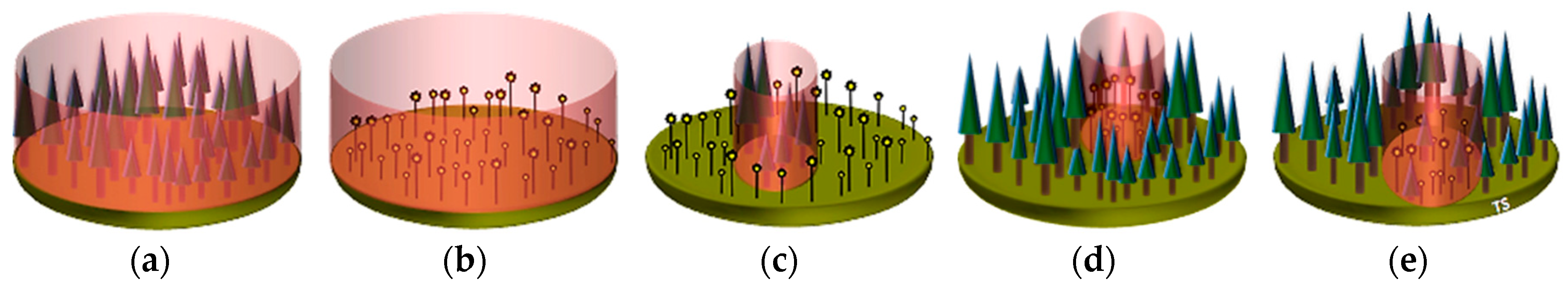
2.2. The Classification System and Inventory Framework

The Italian Land Use Inventory (IUTI) has been adopted to implement the following methodology in order to analyze small landscape patches and their dynamics during the 1990–2013 time-span. IUTI has been promoted and implemented by The Italian Ministry of Environment and Protection of Land and Sea as a key instrument for the National Registry for forest carbon sinks [59]. According to its tessellated stratified sampling scheme, the whole Italian territory was covered by a network of 25-ha squares and one sample point was randomly located within each square [60]. For this work, a sub-sampling strategy was applied in order to further reduce cost and times for photointerpretation [60]. Accordingly, about 13,000 IUTI sampling points were classified based on high-resolution imagery in 1990 and 2013, and according to the classification system proposed by the Intergovernmental Panel on Climate Change (IPCC) [61]. Moreover, a minimum dimensional threshold of 0.5 ha was used to discriminate the land use categories [61]. The coarsest classification adopted six land use classes: forests, cropland, grassland, wetland, settlements, and other lands.
In addition to the basic land use classification, during the photointerpretation phase, sampling points falling within homogeneous patches less than 0.5 ha in size and with a land use different from the surrounding area were marked as “enclosed patches”. Particularly, we distinguished between: (i) small patches with trees within land use classes other than forests, namely TOF, and (ii) small patches without trees within forest, namely SOA. In general terms, the latter can be principally associated with: (i) human activities (i.e., clearings; [44]); (ii) natural disturbances (i.e., treefall causing tree canopy gaps [42]); (iii) the tree crown architecture typical of certain forest types due to the so-called “canopy shyness” phenomenon [52]; (iv) the traditional extensive grazing activities (e.g., the so-called “maggenghi” meadows in the Alps; [62]); (v) the canopy cover gaps due to the ongoing encroaching process in new forest stands [25]. Taking into account forest dynamics and forest ecosystem functions and related services (e.g., biodiversity conservation), in this study we divided SOA into two main sub-types, namely enclosed small open areas (encld-SOA) and encroaching small open areas (encrg-SOA). The former mainly corresponds to gaps associated with traditional grazing activities, while the latter to gaps in open recent secondary forest stands. See Figure 1 for some examples of encld-SOA and encrg-SOA. SOA due to forest harvesting or natural treefall are not considered in the present study because of their temporary nature (i.e., short-term natural evolution processes).
In order to apply the methodological approach based on the integration of inventory and cartographic data proposed by [63,64] for assessing green spaces in urban areas, each polygon surrounding a sampling point classified as TOF or SOA was drawn for both inventory occasions. This integrated approach allows to estimate not only the total coverage, but also the abundance and average size of small patches, which can offer a valuable contribution for better understanding and characterize the historical dynamics as well as their possible implications on landscape structure and functionality.

2.3. Trees outside Forests and Small Open Areas Estimation

Total coverage of small patches (A), abundance (N) and average size (a) at both inventory occasions were estimated, applying the design-based estimation approach developed by [48]. Let Q be the extent of the area covered by the n square grid cells fully overlapping the national territory under the IUTI sampling scheme, the estimate of A is given by:
A ^ = p ^ Q ,
where:
p ^ = n u n ,
where nu is the number of sample points classified as small patches (or their sub-types). The variance of A can be estimated as:
var ^ ( A ^ ) = Q 2 n u ( n n u ) n 2 ( n 1 ) .
Let S and aj be, respectively, the set of small patches (or their sub-types) selected by the n sampling points and the size of the jth patch. Whether aj values are negligible with respect to Q, the estimate of N is given by:
N ^ = Q n j S 1 a j ,
with estimated variance equal to:
var ^ ( N ^ ) = 1 n ( n 1 ) ( Q 2 j S 1 a j 2 n N ^ 2 ) .
Accordingly, the estimate of a is given by A/N, i.e.,
a ¯ ^ = n u j S 1 a j ,
with estimated variance equal to:
var ^ ( a ¯ ^ ) = Q 2 N ^ 2 n ( n 1 ) j S ( 1 a ¯ ^ a j ) 2 .
Considering the standard normal distribution of the variable, a statistical test was performed to assess whether a real variation occurs between estimates at 1990 and 2013. Accordingly, in the present study we considered variation as (i) extremely significant for p value < 0.01, (ii) very significant for p value < 0.05, (iii) significant for p value < 0.1, and (iv) not significant for p value > 0.1.

3. Results

The main findings of the study reveal that the overall number and coverage of small patches, considering both TOF and SOA, increased during the 1990–2013 period. On the contrary, their average size slightly decreased, even if results in this case show different trends between TOF and SOA. Indeed, the average size of TOF essentially remained stable, while that of SOA decreased during the observed time-span (Table 1), passing from 0.16 to 0.07 ha (−56% than the average size at 1990). Even though the increase in the number of patches is higher for SOA (+181.6%) than for TOF (+17.1%), the opposite trend is visible for their total coverage (+18.0% and +27.4%, respectively). The estimates of standard errors are satisfactory for all features at both reference times, ranging from 1.3% to 12.5%.
To better understand the dynamics of small patches, their changes were also compared with those of the two land matrices in which they can occur (i.e., forestlands for SOA, and non-forest lands except water and other lands without vegetation, for TOF), using data reported by [65] as a reference for land use estimates at 2013 in Italy. During the 1990–2013 period, the relative coverage of both TOF and SOA with respect to the surrounding land use matrix increased (+0.5% and +0.7%, respectively). In fact, the relative coverage of TOF passed from 1.6% to 2.1% while that of SOA passed from 5.5% to 6.2% during the observed period. However, it is worth to highlight that while forests increased by about 550,000 ha, the non-forest land uses decreased by about 580,000 ha during this time-span.
The overall increase of SOA, in terms of both abundance and coverage, is almost solely due to the dynamics of encld-SOA. In fact, as shown in Table 2, encld-SOA contribute to 93% of the overall increase in number of SOA, and even more, they are able to even compensate for the negative trend concerning encrg-SOA from 1990 to 2013.
Accordingly, the relative contribution of encld-SOA respect to SOA as a whole, passed from 64.8% to 74.3% in terms of coverage, and from 63.4% to 82.6% in terms of abundance, during the observed period. The average size decreased for both encld-SOA and encrg-SOA, but with major emphasis in the former, for which the 2013 value is 0.06 ha. Even in this case, estimates of standard errors are satisfactory, being in any case below 12%.
Relative transitions between the two SOA sub-types (i.e., encld-SOA and encrg-SOA) and with respect to forest and non-forest matrices (i.e., land use change occurred during the time-span towards a different land use class), were also analyzed (Table 3).
It is worth to highlight that values in rows refer to flows from 1990 to 2013 (loss), while values in columns to flows from 2013 to 1990 (gain). Overall, the results confirm a general increase of SOA coverage, with encld-SOA losing 7.5% mostly due to their shift toward other land uses (i.e., forests), and encrg-SOA losing about 13.3% and mainly converted into encld-SOA (74.4%). Contrarily, encld-SOA show a higher overall increase than encrg-SOA (24.2% and 10.5%, respectively). This gain predominantly occurs at the expense of other land uses for encrg-SOA, while amounts to almost 59% for encld-SOA with the remaining 41% occurring at the expense of encrg-SOA.

4. Discussion

The results reveal that the number and relative coverage of small patches generally increased across the entire Italian territory from 1990 to 2013. In particular, our results show that TOF have increasingly contributed to the diversification of semi-natural (i.e., agricultural lands) and artificial land uses. On the other hand, the decrease in average size of SOA and their strong relation with successional stages, as demonstrated by the transition from encrg-SOA to encld-SOA and from the decrease of the latter within established stands, indicate that their contribution might slightly decrease in the medium-long term due to forest expansion (landscape homogenization).
These findings extend those of several studies carried out at regional and local scales. However, the comparison with such studies is not an easy task, because of the different thresholds usually fixed to distinguish small from large patches. In addition, forests are usually aggregated, and enclosed small open patches are included in the open forest class, as a mixture of agricultural and non-agricultural lands, and thus they are difficult to distinguish from aerial photographs [66]. The same occurs at the global scale, where spontaneous reforestation led to an increase and a decrease of forest area and open patch sizes and numbers, respectively, but with some inconsistencies probably related to the lack of distinction between large and small patches [29]. Usually, the reduction of the total size of open lands is interpreted as negative for ecological connectivity in Europe, because a large part of the plant and animal biodiversity is associated with open habitats of human origin. However, species with small home ranges and a short dispersal distance are more influenced by changes at the small patch level, while only species with larger home ranges and longer dispersal distances will be affected by the loss of larger patches.
The relative coverage of TOF with respect to the national surface increased from 1.1% at 1990 to 1.4% at 2013, with an average patch size almost stable around 0.1 ha. These results are in line with those obtained by [53] in Molise Region, where TOF cover 1.7% of the regional territory, having an average patch size of 0.14 ha at 2008. Our results are slightly lower than those obtained by [54] in Central Italy, where TOF cover almost 2.3% of the territory and with an average patch size of 0.21 ha, but with large variability among the four regions considered. However, as explicitly reported by [54], the analyses were performed on four administrative regions where TOF coverage is particularly high, thus justifying these differences. If our estimates are compared with those reported by the 2017 Great Britain’s National Forest Inventory [67], which used the same classification system adopted by the present study, Italy has less TOF relative coverage than GB (1.4% and 3.2%, respectively), but a larger forest area [68]. In spite of the recent debate around TOF, only few studies have been conducted so far and limited to regional scales [69]. However, if compared with those by [51] at the regional scale in the Czech Republic during the 1953–2014 period, our results show similar dynamics about the overall increase of TOF coverage. Consistently with [51]’ results, we found that TOF both disappeared because it was incorporated in recently expanded forest lands, and appeared in agricultural lands. Both processes have been driven by the abandonment of agricultural practices, which in turn originated in forest expansion and TOF formation and their enlargement in other land uses other than forest. Indeed, we observed that the increase of TOF in the 1990–2013 period inversely relates with the loss of agricultural lands (+27.4% and −8.5%, respectively; [65]). This trend can be interpreted as an important extension of the green infrastructure network, through which the ecological connectivity at lower scales is further strengthened (i.e., landscape to regional) [70]. The mitigation of threats and pressures coming from the surrounding land uses and processes (e.g., urbanization and agricultural intensification) offered by TOF’s network should be considered, and the TOF’s functions evaluated according to different landscape patterns [54,71]. In our case, the average patch size of TOF remained almost stable, despite a general increase in already existing TOF due to the small size of newly formed TOF.
The raising relative contribution in terms of coverage for both TOF and SOA has probably different characteristics whether taking into account the opposite trends in the land use matrices in which they occur. In fact, the relative contribution of TOF mainly increases because of the decrease of the land use matrix during the same period, while the increase in the relative contribution of SOA is exclusively due to the their own coverage increase. Moreover, results show that non-forested landscape are becoming more diverse thanks to the increase of small patches, while the decrease in average size of SOA and their coverage increase mostly related to encld-SOA, thus mostly coming from trees encroachment processes, could led to a progressive homogenization and simplification of forested landscapes in the medium-long term period.
Results show a reduction in average patch size of SOA, particularly regarding encld-SOA; (−62% with respect to the average patch size at 1990). This trend indicates the closure of these patches due to forest expansion and tree densification as a consequence of the progressive abandonment of extensive grazing and forest management practices [72]. We observed a rate of reduction similar to what has been detected at local scales [30]. Similarly, other authors have detected larger differences in the response of metrics over time at smaller spatial extents, and a stronger reduction in small patch size in completely abandoned forestlands, rather than in low-intensively managed watersheds [28].
This is confirmed by the in-depth analysis of the IUTI sampling points classified as SOA in 1990 and 2013, showing that 45.5% of them experienced a change in the reference period (i.e., new SOA, disappearing or shifting from one sub-type to another). This is also consistent with the evident dynamics in Mediterranean forests, triggered by land use and climate change, especially regarding the modifications of species composition and spatial structure [73]. Considering the key role played by forest structure on productivity [74], biodiversity [75], and the resistance/resilience [76] of forest ecosystems, these dynamics deserve particular attention from forest managers. At a broader scale (i.e., landscape), forest management and planning should valorize the role of small forest patches as contributing to ecological connectivity (in terms of e.g., species corridors, refugia, seed dispersers, and pollinators; [77,78]).
Looking at our results, the low increase in the number of patches of encrg-SOA compared to encld-SOA, and their relatively unchanged coverage overtime, might be related to the progressive slowdown of forest expansion processes in Italy during the most recent years [65]. Considering the origin of encrg-SOA (usually associated with recent secondary forests; [79]), future active forest management should be considered as a valuable option towards the long-term maintenance of their functionality and stability [80]. Results also suggest that recently formed encld-SOA are mainly represented by residual canopy gaps in the successional phases. Therefore, if a further decrease in forest harvesting and extensive grazing coupled with a progressive decrease in forest expansion in the future is hypothesized, a general negative trend in SOA in the medium to long term will be expected, as well as negative implications on their ecological roles. This is particularly true if considering that these small patches are prone to the rapid invasion of fast growing and light demanding species [80]. Furthermore, it is worth noting that only 41.2% of SOA belongs to permanent encld-SOA, probably having the highest ecological value if it is considered that they effectively contribute to the heterogeneity of mature stands [42]. Accordingly, from a management perspective, management activities oriented towards their maintenance should be set as a conservation priority. With this regard, a future scenario of increase of the harvesting rate could be also possible, consistently with the sustainable mobilization of wood [81]. In this case, competent authorities should resist the temptation to develop a bimodal forest landscape pattern (frequent timber harvest, including clearcut, and no timber harvest) and to simplify the forest plan requirements, because this will result in the loss of small patches [82].

5. Conclusions

In the present work, we demonstrated that small patches do not represent a negligible component, at least in quantitative terms, of heterogeneous landscapes. TOF represent essential elements of the “green infrastructure” network (e.g., [83]), and SOA contribute to forest heterogeneity, biodiversity conservation, and ecosystem services’ provision. The observed results underline that the management of secondary forests may reverse the impact of land use change (LUC), and give an opportunity to maintain ecosystem functionality and resilience in diversified landscapes.
Open patches play also a key role for the conservation of EU habitats [77]. To bridge the gap between forest planning and habitat conservation, enclosed patches may be included in the ordinary silvicultural plans, and the (larger) open patches may be a focus of rural farming plans. A support is therefore needed for those restoration actions aiming at levelling out habitat gains and losses through the conservation of small patches. The current scenario of wood accumulation might conduct the forest landscape of Italy to a bifurcated model of intensive logging against total conservation, undermining the historical land mosaic patterns, namely of small patches, which are a key-habitat feature of small home-range species, as well as non-matching with stakeholders’ expectations (e.g., in Switzerland; [66]).
From a methodological perspective, the integrated approach (i.e., coupling inventory and cartographic data) we propose can be considered particularly valuable for large-scale assessment of small landscape patches and related temporal and spatial dynamics. Moreover, the proposed approach seems to be cost- and time-effective in updating processes, as well as for obtaining accurate and reliable data. In addition, it enables a cross-comparison between small patches dynamics and surrounding landscape patterns. Considering the ecological and economic relevance of small forest patches, a deeper understanding of their spatial arrangement may increase their “edge-effect”, and enhance the ecosystem services’ flow, thus counterbalancing the disservices coming from the agricultural intensification [84]. Further work should deal with the inventory of temporal and spatial changes in other patch metrics like shape, which might be equally important than size and density in assessing habitat quality and landscape ecosystem services. In conclusion, sustainable land management and conservation planning should (i) incorporate small forest patches and associated dynamics, into current intervention plans; (ii) balance biological conservation with other landscape services (e.g., small vs. large heaths; [85]); (iii) include effective landscape restoration actions [25]; and (iv) consider local knowledge, in combination with remote-sensing techniques, when assessing and mapping the historical landscape changes (e.g., participatory mapping; [45]). As at the basis of sustainability, the consideration of small elements in landscape planning indeed contributes to further understand the impacts of landscape complexity and the related slow processes of change for local wellbeing, otherwise neglected when looking at broader scales.

Author Contributions

Conceptualization, L.S. and M.M.; Data curation, L.S.; Formal analysis, L.S., M.d.C., M.M.H. and B.L.; Investigation, L.S. and M.V.; Resources, B.L. and M.M.; Supervision, L.S., B.L. and M.M.; Validation, B.L.; Visualization, M.d.C. and T.S.; Writing—original draft, L.S., M.d.C. and M.M.H.; Writing—review & editing, M.V. and T.S.

Funding

This project has been partially supported in the framework of the LIFE project “FRESh LIFE—Demonstrating Remote Sensing integration in sustainable forest management” (LIFE14 ENV/IT/000414).

Acknowledgments

We thank Marco Ottaviano from University of Molise for his supervision during the photointerpretation phase. We also thank the three anonymous reviewers for their useful comments and remarks that improved the quality of the manuscript.

Conflicts of Interest

The authors declare no conflict of interest. The views expressed are purely those of the writers and may not in any circumstances be regarded as stating an official position of the European Commission or any other Government Agency.

References

  1. Lausch, A.; Blaschke, T.; Haase, D.; Herzog, F.; Syrbe, R.U.; Tischendorf, L.; Walz, U. Understanding and quantifying landscape structure—A review on relevant process characteristics, data models and landscape metrics. Ecol. Modell. 2015, 295, 31–41. [Google Scholar] [CrossRef]
  2. Forman, R.T. Foundations. In The Ecological Design and Planning Reader; Ndubisi Forster, O., Ed.; Island Press: Washington, DC, USA, 2014; p. 217. ISBN 978-1-59726-646-8. [Google Scholar]
  3. Fahrig, L. Ecological Responses to Habitat Fragmentation Per Se. Annu. Rev. Ecol. Evol. Syst. 2017, 48. [Google Scholar] [CrossRef]
  4. Turner, M.G. Landscape ecology: The effect of pattern on process. Annu. Rev. Ecol. Syst. 1989, 20, 171–197. [Google Scholar] [CrossRef]
  5. Cushman, S.A.; Gutzweiler, K.; Evans, J.S.; McGarigal, K. The gradient paradigm: A conceptual and analytical framework for landscape ecology. In Spatial Complexity, Informatics, and Wildlife Conservation; Cushman, S.A., Huettmann, F., Eds.; Springer: Tokyo, Japan, 2010; pp. 83–108. ISBN 978-4-431-87770-7. [Google Scholar]
  6. Ellis, E.C.; Kaplan, J.O.; Fuller, D.Q.; Vavrus, S.; Klein Goldewijk, K.; Verburg, P.H. Used planet: A global history. Proc. Natl Acad. Sci. USA 2013, 110, 7978–7985. [Google Scholar] [CrossRef] [PubMed] [Green Version]
  7. Antrop, M. Why landscapes of the past are important for the future. Landsc. Urban Plan. 2005, 70, 21–34. [Google Scholar] [CrossRef]
  8. Plieninger, T.; Kizos, T.; Bieling, C.; Dû-Blayo, L.L.; Budniok, M.A.; Bürgi, M.; Crumley, C.L.; Girod, G.; Howard, P.; Kolen, J.; et al. Exploring ecosystem-change and society through a landscape lens: Recent progress in european landscape research. Ecol. Soc. 2015, 20. [Google Scholar] [CrossRef]
  9. Antrop, M. The concept of traditional landscapes as a base for landscape evaluation and planning. The example of flanders region. Landsc. Urban Plan. 1997, 38, 105–117. [Google Scholar] [CrossRef]
  10. Scarascia-Mugnozza, G.; Oswald, H.; Piussi, P.; Radoglou, K. Forests of the Mediterranean region: Gaps in knowledge and research needs. For. Ecol. Manag. 2000, 132, 97–109. [Google Scholar] [CrossRef]
  11. Blondel, J. The “design” of Mediterranean landscapes: A millennial story of humans and ecological systems during the historic period. Hum. Ecol. 2006, 34, 713–729. [Google Scholar] [CrossRef]
  12. Agnoletti, M. Rural landscape, nature conservation and culture: Some notes on research trends and management approaches from a (southern) European perspective. Landsc. Urban Plan. 2014, 126, 66–73. [Google Scholar] [CrossRef]
  13. Falcucci, A.; Maiorano, L.; Boitani, L. Changes in land-use/land-cover patterns in Italy and their implications for biodiversity conservation. Landsc. Ecol. 2007, 22, 617–631. [Google Scholar] [CrossRef]
  14. Kuemmerle, T.; Levers, C.; Erb, K.; Estel, S.; Jepsen, M.R.; Müller, D.; Plutzar, C.; Stürck, J.; Verkerk, P.J.; Verburg, P.H.; et al. Hotspots of land use change in Europe. Environ. Res. Lett. 2016, 11. [Google Scholar] [CrossRef]
  15. Navarro, L.M.; Pereira, H.M. Rewilding abandoned landscapes in Europe. In Rewilding European Landscapes; Springer: Cham, Switzerland, 2015; pp. 3–23. ISBN 9783319120393. [Google Scholar]
  16. Recanatesi, F.; Clemente, M.; Grigoriadis, E.; Ranalli, F.; Zitti, M.; Salvati, L. A Fifty-Year Sustainability Assessment of Italian Agro-Forest Districts. Sustainability 2016, 8, 32. [Google Scholar] [CrossRef]
  17. Sallustio, L.; Pettenella, D.; Merlini, P.; Romano, R.; Salvati, L.; Marchetti, M.; Corona, P. Assessing the economic marginality of agricultural lands in Italy to support land use planning. Land Use Policy 2018, 76, 526–534. [Google Scholar] [CrossRef]
  18. Zitti, M.; Ferrara, C.; Perini, L.; Carlucci, M.; Salvati, L. Long-Term Urban Growth and Land Use Efficiency in Southern Europe: Implications for Sustainable Land Management. Sustainability 2015, 7, 3359–3385. [Google Scholar] [CrossRef] [Green Version]
  19. Romano, B.; Zullo, F.; Fiorini, L.; Ciabò, S.; Marucci, A. Sprinkling: An approach to describe urbanization dynamics in Italy. Sustainability 2017, 9, 97. [Google Scholar] [CrossRef]
  20. Salvati, L.; Munafo, M.; Morelli, V.G.; Sabbi, A. Low-density settlements and land use changes in a Mediterranean urban region. Landsc. Urban Plan. 2012, 105, 43–52. [Google Scholar] [CrossRef]
  21. Romano, B.; Zullo, F. The urban transformation of Italy’s adriatic coastal strip: Fifty years of unsustainability. Land Use Policy 2014, 38, 26–36. [Google Scholar] [CrossRef]
  22. Rivieccio, R.; Sallustio, L.; Paolanti, M.; Vizzarri, M.; Marchetti, M. Where Land Use Changes Occur: Using Soil Features to Understand the Economic Trends in Agricultural Lands. Sustainability 2017, 9, 78. [Google Scholar] [CrossRef]
  23. Tarolli, P.; Preti, F.; Romano, N. Terraced landscapes: From an old best practice to a potential hazard for soil degradation due to land abandonment. Anthropocene 2014, 6, 10–25. [Google Scholar] [CrossRef]
  24. Queiroz, C.; Beilin, R.; Folke, C.; Lindborg, R. Farmland abandonment: Threat or opportunity for biodiversity conservation? A global review. Front. Ecol. Environ. 2014, 12, 288–296. [Google Scholar] [CrossRef]
  25. Marchetti, M.; Vizzarri, M.; Sallustio, L.; di Cristofaro, M.; Lasserre, B.; Lombardi, F.; Giancola, C.; Perone, A.; Simpatico, A.; Santopuoli, G. Behind forest cover changes: Is natural regrowth supporting landscape restoration? Findings from Central Italy. Plant Biosyst. 2018, 152, 524–535. [Google Scholar] [CrossRef]
  26. Malek, Ž.; Boerboom, L.; Glade, T. Future Forest Cover Change Scenarios with Implications for Landslide Risk: An Example from Buzau Subcarpathians, Romania. Environ. Manag. 2015, 56, 1228–1243. [Google Scholar] [CrossRef] [PubMed]
  27. Fonderflick, J.; Besnard, A.; Martin, J.L. Species traits and the response of open-habitat species to forest edge in landscape mosaics. Oikos 2013, 122, 42–51. [Google Scholar] [CrossRef]
  28. Campagnaro, T.; Frate, L.; Carranza, M.L.; Sitzia, T. Multi-scale analysis of alpine landscapes with different intensities of abandonment reveals similar spatial pattern changes: Implications for habitat conservation. Ecol. Indic. 2017, 74, 147–159. [Google Scholar] [CrossRef]
  29. Sitzia, T.; Semenzato, P.; Trentanovi, G. Natural reforestation is changing spatial patterns of rural mountain and hill landscapes: A global overview. For. Ecol. Manag. 2010, 259, 1354–1362. [Google Scholar] [CrossRef]
  30. Bracchetti, L.; Carotenuto, L.; Catorci, A. Land-cover changes in a remote area of central Apennines (Italy) and management directions. Landsc. Urban Plan. 2012, 104, 157–170. [Google Scholar] [CrossRef]
  31. Marchetti, M.; Lasserre, B.; Pazzagli, R.; Sallustio, L. Rural areas and urbanization: Analysis of a change. Sci. Territ. 2014, 2, 239–258. [Google Scholar]
  32. Verburg, P.H.; Schulp, C.J.E.; Witte, N.; Veldkamp, A. Downscaling of land use change scenarios to assess the dynamics of European landscapes. Agric. Ecosyst. Environ. 2006, 114, 39–56. [Google Scholar] [CrossRef]
  33. Persson, A.S.; Olsson, O.; Rundlöf, M.; Smith, H.G. Land use intensity and landscape complexity-Analysis of landscape characteristics in an agricultural region in Southern Sweden. Agric. Ecosyst. Environ. 2010, 136, 169–176. [Google Scholar] [CrossRef]
  34. Doré, T.; Makowski, D.; Malézieux, E.; Munier-Jolain, N.; Tchamitchian, M.; Tittonell, P. Facing up to the paradigm of ecological intensification in agronomy: Revisiting methods, concepts and knowledge. Eur. J. Agron. 2011, 34, 197–210. [Google Scholar] [CrossRef] [Green Version]
  35. Bellefontaine, R.; Petit, S.; Pain-Orcet, M.; Deleporte, P.; Bertault, J.-G. Trees Outside Forests—Towards Better Awareness; FAO: Rome, Italy, 2002; ISBN 9251046565. [Google Scholar]
  36. FAO Global Forest Resources Assessment 2000; FAO: Rome, Italy, 2001.
  37. Pollard, E.; Hooper, M.D.; Moore, N.W. Hedges; Collins: London, UK, 1974; ISBN 0002190818. [Google Scholar]
  38. Schnell, S.; Kleinn, C.; Ståhl, G. Monitoring trees outside forests: A review. Environ. Monit. Assess. 2015, 187. [Google Scholar] [CrossRef] [PubMed]
  39. Schnell, S. Integrating Trees Outside Forests into National Forest Inventories; Swedish University of Agricultural Sciences: Uppsala, Sweden, 2015; Volume 37. [Google Scholar]
  40. Endreny, T.A. Biodiversity, traditional landscapes and agroecosystem management. J. For. 2002, 100, 35–40. [Google Scholar] [CrossRef]
  41. Gumiero, B.; Boz, B. Il ruolo delle siepi come fasce tampone e corridoi fluviali. Alberi e Territ. 2007, 4, 31. [Google Scholar]
  42. Muscolo, A.; Bagnato, S.; Sidari, M.; Mercurio, R. A review of the roles of forest canopy gaps. J. For. Res. 2014, 25, 725–736. [Google Scholar] [CrossRef]
  43. Bari, M.A.; Smettem, K.R.J. A conceptual model of daily water balance following partial clearing from forest to pasture. Hydrol. Earth Syst. Sci. 2006, 10, 321–337. [Google Scholar] [CrossRef] [Green Version]
  44. Frank, C.; Ruck, B. Numerical study of the airflow over forest clearings. Forestry 2008, 81, 259–277. [Google Scholar] [CrossRef] [Green Version]
  45. Chazdon, R.L.; Brancalion, P.H.S.; Laestadius, L.; Bennett-Curry, A.; Buckingham, K.; Kumar, C.; Moll-Rocek, J.; Vieira, I.C.G.; Wilson, S.J. When is a forest a forest? Forest concepts and definitions in the era of forest and landscape restoration. Ambio 2016, 45, 538–550. [Google Scholar] [CrossRef] [PubMed] [Green Version]
  46. Arnillas, C.A.; Tovar, C.; Cadotte, M.W.; Buytaert, W. From patches to richness: Assessing the potential impact of landscape transformation on biodiversity. Ecosphere 2017, 8. [Google Scholar] [CrossRef]
  47. Rentch, J.S.; Ray, R.; Hicks, J. Changes in presettlement forest composition for five areas in the central hardwood forest. Nat. Areas J. 2005, 25, 228–238. [Google Scholar]
  48. Baffetta, F.; Fattorini, L.; Corona, P. Estimation of small woodlot and tree row attributes in large-scale forest inventories. Environ. Ecol. Stat. 2011, 18, 147–167. [Google Scholar] [CrossRef] [Green Version]
  49. Turner, D.; Lucieer, A.; Watson, C. An automated technique for generating georectified mosaics from ultra-high resolution Unmanned Aerial Vehicle (UAV) imagery, based on Structure from Motion (SFM) point clouds. Remote Sens. 2012, 4, 1392–1410. [Google Scholar] [CrossRef]
  50. Dandois, J.P.; Ellis, E.C. High spatial resolution three-dimensional mapping of vegetation spectral dynamics using computer vision. Remote Sens. Environ. 2013, 136, 259–276. [Google Scholar] [CrossRef]
  51. Novotný, M.; Skaloš, J.; Plieninger, T. Spatial-temporal changes in trees outside forests: Case study from the Czech Republic 1953–2014. Appl. Geogr. 2017, 87, 139–148. [Google Scholar] [CrossRef]
  52. Bagaram, M.B.; Giuliarelli, D.; Chirici, G.; Giannetti, F.; Barbati, A. UAV Remote Sensing for Biodiversity Monitoring: Are Forest Canopy Gaps Good Covariates? Remote Sens. 2018, 10, 1397. [Google Scholar] [CrossRef]
  53. Marchetti, M.; Garfì, V.; Pisani, C.; Franceschi, S.; Marcheselli, M.; Corona, P.; Puletti, N.; Vizzarri, M.; di Cristofaro, M.; Ottaviano, M.; et al. Inference on forest attributes and ecological diversity of trees outside forest by a two-phase inventory. Ann. For. Sci. 2018, 75, 37. [Google Scholar] [CrossRef]
  54. Paletto, A.; De Natale, F.; Gasparini, P.; Morelli, S.; Tosi, V. Trees Outside Forests (TOF) inventory as a tool for landscape analysis and support for territorial planning. For. Riv. Selvic. Ecol. For. 2006, 3, 253–266. [Google Scholar] [CrossRef]
  55. Hamel, P.; Bryant, B.P. Uncertainty assessment in ecosystem services analyses: Seven challenges and practical responses. Ecosyst. Serv. 2017, 24, 1–15. [Google Scholar] [CrossRef]
  56. Sallustio, L.; Simpatico, A.; Munafò, M.; Giancola, C.; Tognetti, R.; Vizzarri, M.; Marchetti, M. Recent trends in forest cover changes: Only positive implications? L’Italia For. E Mont. 2015, 70, 273–294. [Google Scholar] [CrossRef]
  57. Corona, P.; Barbati, A.; Tomao, A.; Bertani, R.; Valentini, R.; Marchetti, M.; Fattorini, L.; Perugini, L. Land use inventory as framework for environmental accounting: An application in Italy. iForest 2012, 5, 204–209. [Google Scholar] [CrossRef] [Green Version]
  58. Palombo, C.; Chirici, G.; Marchetti, M.; Tognetti, R. Is land abandonment affecting forest dynamics at high elevation in Mediterranean mountains more than climate change? Plant Biosyst. 2013, 147, 1–11. [Google Scholar] [CrossRef]
  59. Marchetti, M.; Bertani, R.; Corona, P.; Valentini, R. Changes of forest coverage and land uses as assessed by the inventory of land uses in Italy. For. Riv. Selvic. Ecol. For. 2012, 9, 170–184. [Google Scholar] [CrossRef] [Green Version]
  60. Fattorini, L. Design-based methodological advances to support national forest inventories: A review of recent proposals. iForest Biogeosci. For. 2015, 8, 6–11. [Google Scholar] [CrossRef]
  61. Intergovernmental Panel on Climate Change (IPCC). Good Practice Guidance for Land Use, Land-Use Change and Forestry; IPCC: Kanagawa, Japan, 2003. [Google Scholar]
  62. Sitzia, T.; Trentanovi, G. Maggengo meadow patches enclosed by forests in the Italian Alps: Evidence of landscape legacy on plant diversity. Biodivers. Conserv. 2011, 20, 945–961. [Google Scholar] [CrossRef]
  63. Corona, P.; Agrimi, M.; Baffetta, F.; Barbati, A.; Chiriacò, M.V.; Fattorini, L.; Pompei, E.; Valentini, R.; Mattioli, W. Extending large-scale forest inventories to assess urban forests. Environ. Monit. Assess. 2012, 184, 1409–1422. [Google Scholar] [CrossRef] [PubMed] [Green Version]
  64. Sallustio, L.; Perone, A.; Vizzarri, M.; Corona, P.; Fares, S.; Cocozza, C.; Tognetti, R.; Lasserre, B.; Marchetti, M. The green side of the grey: Assessing greenspaces in built-up areas of Italy. Urban For. Urban Green. 2017. [CrossRef]
  65. Pagliarella, M.C.; Sallustio, L.; Capobianco, G.; Conte, E.; Corona, P.; Fattorini, L.; Marchetti, M. From one- to two-phase sampling to reduce costs of remote sensing-based estimation of land-cover and land-use proportions and their changes. Remote Sens. Environ. 2016, 184, 410–417. [Google Scholar] [CrossRef]
  66. Bolliger, J.; Kienast, F.; Soliva, R.; Rutherford, G. Spatial sensitivity of species habitat patterns to scenarios of land use change (Switzerland). Landsc. Ecol. 2007, 22, 773–789. [Google Scholar] [CrossRef]
  67. Brewer, A.; Ditchburn, B.; Cross, D.; Whitton, E.; Ward, A. Tree Cover Outside Woodland in Great Britain—Summary Report; Forestry Commission: Edinburgh, UK, 2017. [Google Scholar]
  68. European Commision State of Europe’ Forest 2015; Ministerial Conference on the Protection of Forests in Europe; FOREST EUROPE Liaison Unit: Madrid, Spain, 2015.
  69. Plieninger, T. Monitoring directions and rates of change in trees outside forests through multitemporal analysis of map sequences. Appl. Geogr. 2012, 32, 566–576. [Google Scholar] [CrossRef] [Green Version]
  70. Rossi, J.P.; Garcia, J.; Roques, A.; Rousselet, J. Trees outside forests in agricultural landscapes: Spatial distribution and impact on habitat connectivity for forest organisms. Landsc. Ecol. 2016, 31, 243–254. [Google Scholar] [CrossRef]
  71. Plieninger, T.; Levers, C.; Mantel, M.; Costa, A.; Schaich, H.; Kuemmerle, T. Patterns and drivers of scattered tree loss in agricultural landscapes: Orchard meadows in Germany (1968–2009). PLoS ONE 2015, 10, e0126178. [Google Scholar] [CrossRef] [PubMed]
  72. Sanz, A.S.R.; Fernandez, C.; Mouillot, F.; Ferrat, L.; Istria, D.; Pasqualini, V. Long-term forest dynamics and land-use abandonment in the Mediterranean Mountains, Corsica, France. Ecol. Soc. 2013, 18. [Google Scholar] [CrossRef]
  73. Valladares, F.; Benavides, R.; Rabasa, S.G.; Diaz, M.; Pausas, J.G.; Paula, S.; Simonson, W.D. Global change and Mediterranean forests: Current impacts and potential responses. In Forests and Global Change; Coomes, D.A., Ed.; Cambridge University Press: Cambridge, UK, 2014; p. 447. ISBN 978-1-10732350-6. [Google Scholar]
  74. Hardiman, B.S.; Bohrer, G.; Gough, C.M.; Vogel, C.S.; Curtis, P.S. The role of canopy structural complexity in wood net primary production of a maturing northern deciduous forest. Ecology 2011, 92, 1818–1827. [Google Scholar] [CrossRef] [PubMed]
  75. Lindenmayer, D.B.; Franklin, J.F.; Fischer, J. General management principles and a checklist of strategies to guide forest biodiversity conservation. Biol. Conserv. 2006, 131, 433–445. [Google Scholar] [CrossRef]
  76. Schütz, J.P. Silvicultural tools to develop irregular and diverse forest structures. Forestry 2002, 75, 329–337. [Google Scholar] [CrossRef] [Green Version]
  77. Varela, E.; Verheyen, K.; Valdés, A.; Soliño, M.; Jacobsen, J.B.; De Smedt, P.; Ehrmann, S.; Gärtner, S.; Górriz, E.; Decocq, G. Promoting biodiversity values of small forest patches in agricultural landscapes: Ecological drivers and social demand. Sci. Total Environ. 2018, 619–620, 1319–1329. [Google Scholar] [CrossRef] [PubMed]
  78. Arroyo-Rodríguez, V.; Melo, F.P.; Martínez-Ramos, M.; Bongers, F.; Chazdon, R.L.; Meave, J.A.; Norden, N.; Santos, B.A.; Leal, I.R.; Tabarelli, M. Multiple successional pathways in human-modified tropical landscapes: New insights from forest succession, forest fragmentation and landscape ecology research. Biol. Rev. Camb. Philos. Soc. 2017, 92, 326–340. [Google Scholar] [CrossRef] [PubMed]
  79. Král, K.; Shue, J.; Vrška, T.; Gonzalez-Akre, E.B.; Parker, G.G.; McShea, W.J.; McMahon, S.M. Fine-scale patch mosaic of developmental stages in Northeast American secondary temperate forests: The European perspective. Eur. J. For. Res. 2016, 135, 981–996. [Google Scholar] [CrossRef]
  80. Brokaw, N.V.L. Gap-Phase Regeneration of Three Pioneer Tree Species in a Tropical Forest. J. Ecol. 1987, 75, 9–19. [Google Scholar] [CrossRef]
  81. European Commision Good Practice Guidance on the Sustainable Mobilisation of Wood in Europe; Ministerial Conference on the Protection of Forests in Europe; FOREST EUROPE Liaison Unit: Oslo, Norway, 2010.
  82. Trentanovi, G.; Campagnaro, T.; Rizzi, A.; Sitzia, T. Synergies of planning for forests and planning for Natura 2000: Evidences and prospects from northern Italy. J. Nat. Conserv. 2018, 43, 239–249. [Google Scholar] [CrossRef]
  83. De Foresta, H.; Somarriba, E.; Temu, A.; Boulanger, D.; Feuilly, H.; Gauthier, M. Towards the Assessment of Trees Outside Forests: A Thematic Report Prepared in the Framework of the Global Forest Resources Assessment; Food and Agriculture Organization (FAO): Rome, Italy, 2013. [Google Scholar]
  84. Decocq, G.; Andrieu, E.; Brunet, J.; Chabrerie, O.; De Frenne, P.; De Smedt, P.; Deconchat, M.; Diekmann, M.; Ehrmann, S.; Giffard, B.; et al. Ecosystem Services from Small Forest Patches in Agricultural Landscapes. Curr. For. Rep. 2016, 2, 30–44. [Google Scholar] [CrossRef] [Green Version]
  85. Cordingley, J.E.; Newton, A.C.; Rose, R.J.; Clarke, R.T.; Bullock, J.M. Can landscape-scale approaches to conservation management resolve biodiversity-ecosystem service trade-offs? J. Appl. Ecol. 2016, 53, 96–105. [Google Scholar] [CrossRef] [Green Version]
Figure 1. Schematic representation of the land cover types surveyed in this study. Forestland (a), non-forest semi-natural land (b), trees outside forest (TOF) (c), enclosed small open areas (encld-SOA) (d), encroaching small open areas (encrg-SOA) (e).
Forests 09 00701 g001
Table 1. Number (N), coverage (A, in ha) and average size (a, in ha) of small patches (SOA and TOF) at 1990 and 2013 (±their estimated relative standard errors, in percentage). Significance levels (not significant for p value > 0.1, significant for p value ≤ 0.1, very significant for p value ≤ 0.05 and extremely significant for p value ≤ 0.01) of changes between 1990 and 2013 (Δ) are also reported in the summary tables with the relative symbol (n.s., *, **, ***, respectively).
19902013Δ
NAaNAaNAa
TOF3,607,709332,1740.094,223,692423,1810.10615,98391,0070.01
(±2.4%)(±8.2%)(±11.0%)(±2.2%)(±7.3%)(±12.5%)**n.s.
SOA3,246,709505,0870.169,142,196596,0940.075,895,48791,006−0.09
(±2.5%)(±6.6%)(±6.7%)(±1.3%)(±6.1%)(±8.1%)*******
Table 2. Number (N), coverage (A, in ha) and average size (a, in ha) of SOA (encld-SOA and encrg-SOA) at 1990 and 2013 (±their estimated relative standard errors, in percentage). Significance levels (not significant for p value > 0.1, significant for p value ≤ 0.1, very significant for p value ≤ 0.05 and extremely significant for p value ≤ 0.01) of changes between 1990 and 2013 (Δ) are also reported in the summary tables with the relative symbol (n.s., *, **, ***, respectively).
19902013Δ
NAaNAaNAa
ENCRG-SOA1,189,399177,4630.151,594,233159,2620.10404,834−18,201−0.05
(±4.3%)(±11.3%)(±9.9%)(±3.7%)(±12.0%)(±9.8%)***n.s.***
ENCLD-SOA2,057,310327,6240.167,547,963436,8320.065,490,653109,208−0.10
(±3.2%)(±8.3%)(±8.9%)(±1.5%)(±7.2%)(±9.5%)********
Table 3. Cross-tabulation matrix of the flows from one class to another during the 1990–2013 period, expressed in relative terms with respect to the total surface of SOA. Entries along the diagonal refer to persistence from 1990 to 2013.
2013
Forests and Land Uses Other than ForestsEncrg-SOAEncld-SOA
1990Forests and land uses other than forests 10.2%14.3%
Encrg-SOA3.4%13.3%9.9%
Encld-SOA7.5%0.3%41.2%

