Editorial for the Special Issue “Estimation of Crop Phenotyping Traits using Unmanned Ground Vehicle and Unmanned Aerial Vehicle Imagery”


Abstract
:1. Introduction
2. Overview of Contributions
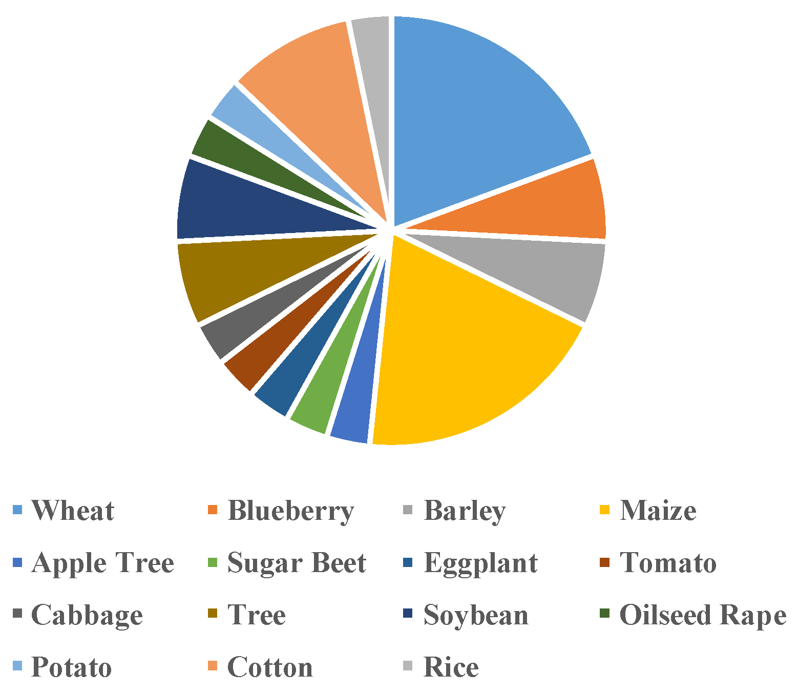
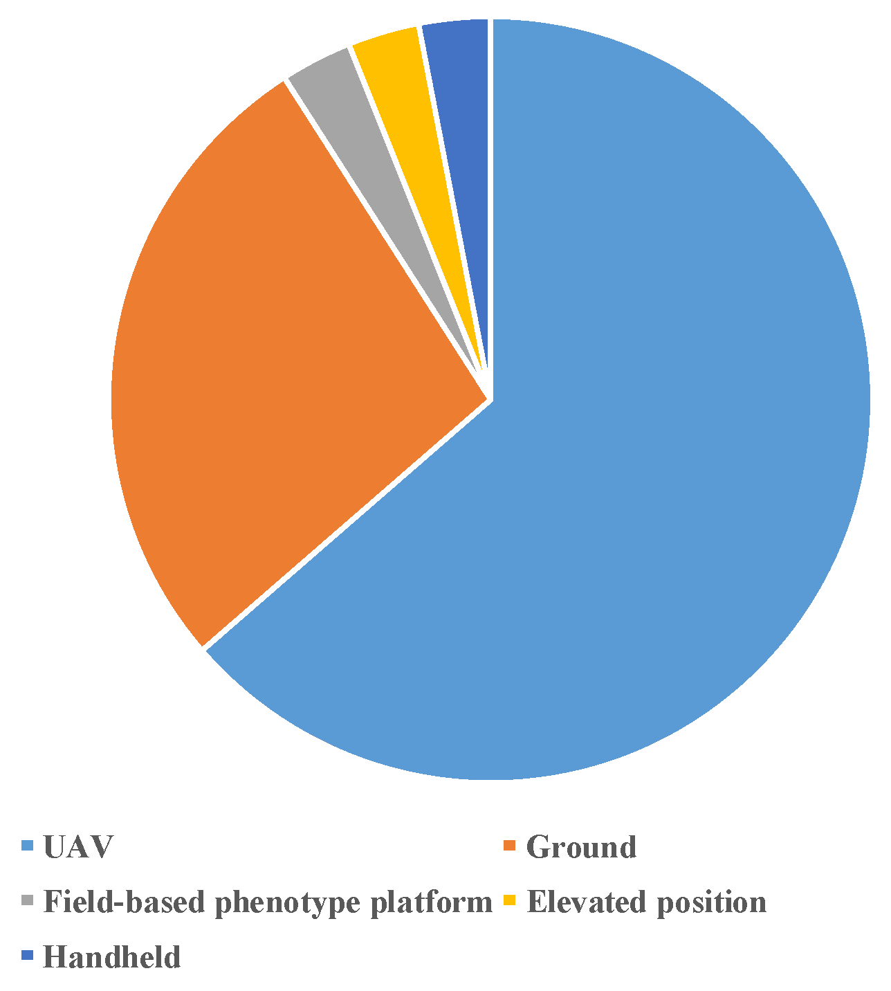
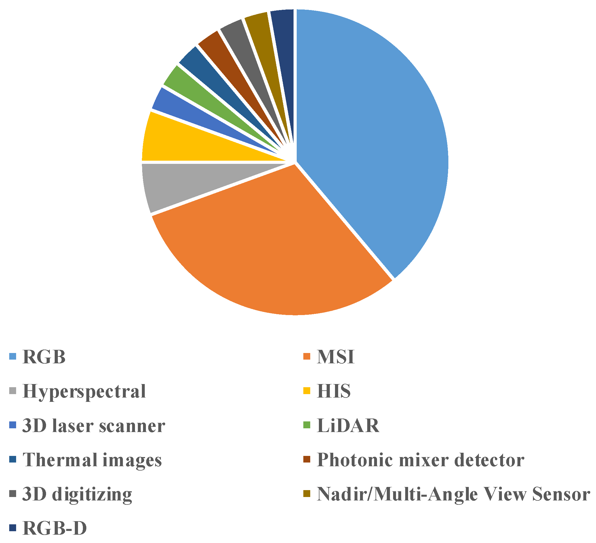
2.1. Platforms and Sensors
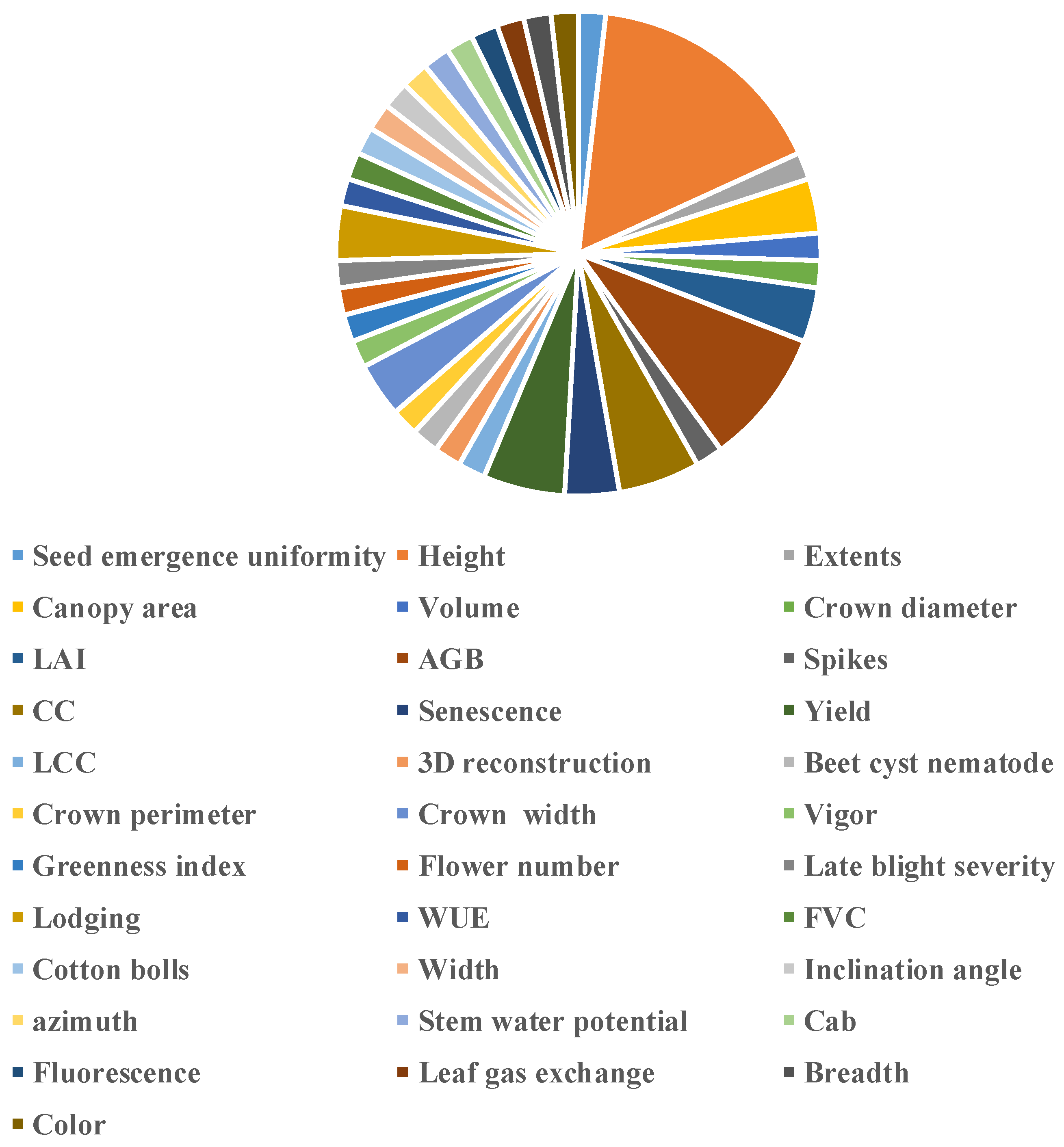
2.2. Phenotyping Traits
2.3. Data Processing Methods
3. Conclusions
Author Contributions
Acknowledgments
Conflicts of Interest
References
- Araus, J.L.; Kefauver, S.C. Breeding to adapt agriculture to climate change: Affordable phenotyping solutions. Curr. Opin. Plant Biol. 2018, 45, 237–247. [Google Scholar] [CrossRef] [PubMed]
- Singh, A.; Ganapathysubramanian, B.; Singh, A.K. Machine Learning for High-Throughput Stress Phenotyping in Plants. Trends Plant Sci. 2015, 21, 110–124. [Google Scholar] [CrossRef] [PubMed] [Green Version]
- Ghanem, M.E.; Marrou Hélène Sinclair, T.R. Physiological phenotyping of plants for crop improvement. Trends Plant Sci. 2015, 20, 139–144. [Google Scholar] [CrossRef] [PubMed]
- Araus, J.L.; Cairns, J.E. Field high-throughput phenotyping: The new crop breeding frontier. Trends Plant Sci. 2014, 19, 52–61. [Google Scholar] [CrossRef]
- Araus, J.L.; Kefauver, S.C.; Zaman-Allah, M.; Olsen, M.S.; Cairns, J.E. Translating High-Throughput Phenotyping into Genetic Gain. Trends Plant Sci. 2018, 23, 451–466. [Google Scholar] [CrossRef] [Green Version]
- Maes, W.H.; Steppe, K. Perspectives for remote sensing with unmanned aerial vehicles in precision agriculture. Trends Plant Sci. 2019, 24, 152–164. [Google Scholar] [CrossRef]
- Liu, T.; Li, R.; Jin, X.; Ding, J.; Zhu, X.; Sun, C.; Guo, W. Evaluation of Seed Emergence Uniformity of Mechanically Sown Wheat with UAV RGB Imagery. Remote Sens. 2017, 9, 1241. [Google Scholar] [CrossRef] [Green Version]
- Patrick, A.; Li, C. High Throughput Phenotyping of Blueberry Bush Morphological Traits Using Unmanned Aerial Systems. Remote Sens. 2017, 9, 1250. [Google Scholar] [CrossRef] [Green Version]
- Yao, X.; Wang, N.; Liu, Y.; Cheng, T.; Tian, Y.; Chen, Q.; Zhu, Y. Estimation of Wheat LAI at Middle to High Levels Using Unmanned Aerial Vehicle Narrowband Multispectral Imagery. Remote Sens. 2017, 9, 1304. [Google Scholar] [CrossRef] [Green Version]
- Yue, J.; Feng, H.; Yang, G.; Li, Z. A Comparison of Regression Techniques for Estimation of Above-Ground Winter Wheat Biomass Using Near-Surface Spectroscopy. Remote Sens. 2018, 10, 66. [Google Scholar] [CrossRef] [Green Version]
- Zhou, C.; Liang, D.; Yang, X.; Xu, B.; Yang, G. Recognition of Wheat Spike from Field Based Phenotype Platform Using Multi-Sensor Fusion and Improved Maximum Entropy Segmentation Algorithms. Remote Sens. 2018, 10, 246. [Google Scholar] [CrossRef] [Green Version]
- Brocks, S.; Bareth, G. Estimating Barley Biomass with Crop Surface Models from Oblique RGB Imagery. Remote Sens. 2018, 10, 268. [Google Scholar] [CrossRef] [Green Version]
- Makanza, R.; Zaman-Allah, M.; Cairns, J.; Magorokosho, C.; Tarekegne, A.; Olsen, M.; Prasanna, B. High-Throughput Phenotyping of Canopy Cover and Senescence in Maize Field Trials Using Aerial Digital Canopy Imaging. Remote Sens. 2018, 10, 330. [Google Scholar] [CrossRef] [Green Version]
- Gracia-Romero, A.; Vergara-Díaz, O.; Thierfelder, C.; Cairns, J.; Kefauver, S.; Araus, J. Phenotyping Conservation Agriculture Management Effects on Ground and Aerial Remote Sensing Assessments of Maize Hybrids Performance in Zimbabwe. Remote Sens. 2018, 10, 349. [Google Scholar] [CrossRef] [Green Version]
- Ma, X.; Feng, J.; Guan, H.; Liu, G. Prediction of Chlorophyll Content in Different Light Areas of Apple Tree Canopies based on the Color Characteristics of 3D Reconstruction. Remote Sens. 2018, 10, 429. [Google Scholar] [CrossRef] [Green Version]
- Joalland, S.; Screpanti, C.; Varella, H.; Reuther, M.; Schwind, M.; Lang, C.; Walter, A.; Liebisch, F. Aerial and Ground Based Sensing of Tolerance to Beet Cyst Nematode in Sugar Beet. Remote Sens. 2018, 10, 787. [Google Scholar] [CrossRef] [Green Version]
- Moeckel, T.; Dayananda, S.; Nidamanuri, R.; Nautiyal, S.; Hanumaiah, N.; Buerkert, A.; Wachendorf, M. Estimation of Vegetable Crop Parameter by Multi-temporal UAV-Borne Images. Remote Sens. 2018, 10, 805. [Google Scholar] [CrossRef] [Green Version]
- Hassan, M.; Yang, M.; Rasheed, A.; Jin, X.; Xia, X.; Xiao, Y.; He, Z. Time-Series Multispectral Indices from Unmanned Aerial Vehicle Imagery Reveal Senescence Rate in Bread Wheat. Remote Sens. 2018, 10, 809. [Google Scholar] [CrossRef] [Green Version]
- Johansen, K.; Raharjo, T.; McCabe, M. Using Multi-Spectral UAV Imagery to Extract Tree Crop Structural Properties and Assess Pruning Effects. Remote Sens. 2018, 10, 854. [Google Scholar] [CrossRef] [Green Version]
- Khan, Z.; Chopin, J.; Cai, J.; Eichi, V.; Haefele, S.; Miklavcic, S. Quantitative Estimation of Wheat Phenotyping Traits Using Ground and Aerial Imagery. Remote Sens. 2018, 10, 950. [Google Scholar] [CrossRef] [Green Version]
- Yue, J.; Feng, H.; Jin, X.; Yuan, H.; Li, Z.; Zhou, C.; Yang, G.; Tian, Q. A Comparison of Crop Parameters Estimation Using Images from UAV-Mounted Snapshot Hyperspectral Sensor and High-Definition Digital Camera. Remote Sens. 2018, 10, 1138. [Google Scholar] [CrossRef] [Green Version]
- Guan, H.; Liu, M.; Ma, X.; Yu, S. Three-Dimensional Reconstruction of Soybean Canopies Using Multisource Imaging for Phenotyping Analysis. Remote Sens. 2018, 10, 1206. [Google Scholar] [CrossRef] [Green Version]
- Wan, L.; Li, Y.; Cen, H.; Zhu, J.; Yin, W.; Wu, W.; Zhu, H.; Sun, D.; Zhou, W.; He, Y. Combining UAV-Based Vegetation Indices and Image Classification to Estimate Flower Number in Oilseed Rape. Remote Sens. 2018, 10, 1484. [Google Scholar] [CrossRef] [Green Version]
- Duarte-Carvajalino, J.; Alzate, D.; Ramirez, A.; Santa-Sepulveda, J.; Fajardo-Rojas, A.; Soto-Suárez, M. Evaluating Late Blight Severity in Potato Crops Using Unmanned Aerial Vehicles and Machine Learning Algorithms. Remote Sens. 2018, 10, 1513. [Google Scholar] [CrossRef] [Green Version]
- Han, L.; Yang, G.; Feng, H.; Zhou, C.; Yang, H.; Xu, B.; Li, Z.; Yang, X. Quantitative Identification of Maize Lodging-Causing Feature Factors Using Unmanned Aerial Vehicle Images and a Nomogram Computation. Remote Sens. 2018, 10, 1528. [Google Scholar] [CrossRef] [Green Version]
- Thorp, K.; Thompson, A.; Harders, S.; French, A.; Ward, R. High-Throughput Phenotyping of Crop Water Use Efficiency via Multispectral Drone Imagery and a Daily Soil Water Balance Model. Remote Sens. 2018, 10, 1682. [Google Scholar] [CrossRef] [Green Version]
- Michez, A.; Bauwens, S.; Brostaux, Y.; Hiel, M.; Garré, S.; Lejeune, P.; Dumont, B. How Far Can Consumer-Grade UAV RGB Imagery Describe Crop Production? A 3D and Multitemporal Modeling Approach Applied to Zea mays. Remote Sens. 2018, 10, 1798. [Google Scholar] [CrossRef] [Green Version]
- Yeom, J.; Jung, J.; Chang, A.; Maeda, M.; Landivar, J. Automated Open Cotton Boll Detection for Yield Estimation Using Unmanned Aircraft Vehicle (UAV) Data. Remote Sens. 2018, 10, 1895. [Google Scholar] [CrossRef] [Green Version]
- Ziliani, M.; Parkes, S.; Hoteit, I.; McCabe, M. Intra-Season Crop Height Variability at Commercial Farm Scales Using a Fixed-Wing UAV. Remote Sens. 2018, 10, 2007. [Google Scholar] [CrossRef] [Green Version]
- Wang, Y.; Wen, W.; Wu, S.; Wang, C.; Yu, Z.; Guo, X.; Zhao, C. Maize Plant Phenotyping: Comparing 3D Laser Scanning, Multi-View Stereo Reconstruction, and 3D Digitizing Estimates. Remote Sens. 2019, 11, 63. [Google Scholar] [CrossRef] [Green Version]
- Tu, Y.; Johansen, K.; Phinn, S.; Robson, A. Measuring Canopy Structure and Condition Using Multi-Spectral UAS Imagery in a Horticultural Environment. Remote Sens. 2019, 11, 269. [Google Scholar] [CrossRef] [Green Version]
- Lobos, G.; Escobar-Opazo, A.; Estrada, F.; Romero-Bravo, S.; Garriga, M.; del Pozo, A.; Poblete-Echeverría, C.; Gonzalez-Talice, J.; González-Martinez, L.; Caligari, P. Spectral Reflectance Modeling by Wavelength Selection: Studying the Scope for Blueberry Physiological Breeding under Contrasting Water Supply and Heat Conditions. Remote Sens. 2019, 11, 329. [Google Scholar] [CrossRef] [Green Version]
- Wilke, N.; Siegmann, B.; Klingbeil, L.; Burkart, A.; Kraska, T.; Muller, O.; van Doorn, A.; Heinemann, S.; Rascher, U. Quantifying Lodging Percentage and Lodging Severity Using a UAV-Based Canopy Height Model Combined with an Objective Threshold Approach. Remote Sens. 2019, 11, 515. [Google Scholar] [CrossRef] [Green Version]
- Feng, L.; Wu, W.; Wang, J.; Zhang, C.; Zhao, Y.; Zhu, S.; He, Y. Wind Field Distribution of Multi-rotor UAV and Its Influence on Spectral Information Acquisition of Rice Canopies. Remote Sens. 2019, 11, 602. [Google Scholar] [CrossRef] [Green Version]
- Thompson, A.; Thorp, K.; Conley, M.; Elshikha, D.; French, A.; Andrade-Sanchez, P.; Pauli, D. Comparing Nadir and Multi-Angle View Sensor Technologies for Measuring in-Field Plant Height of Upland Cotton. Remote Sens. 2019, 11, 700. [Google Scholar] [CrossRef] [Green Version]
- Ma, X.; Zhu, K.; Guan, H.; Feng, J.; Yu, S.; Liu, G. High-Throughput Phenotyping Analysis of Potted Soybean Plants Using Colorized Depth Images Based on A Proximal Platform. Remote Sens. 2019, 11, 1085. [Google Scholar] [CrossRef] [Green Version]


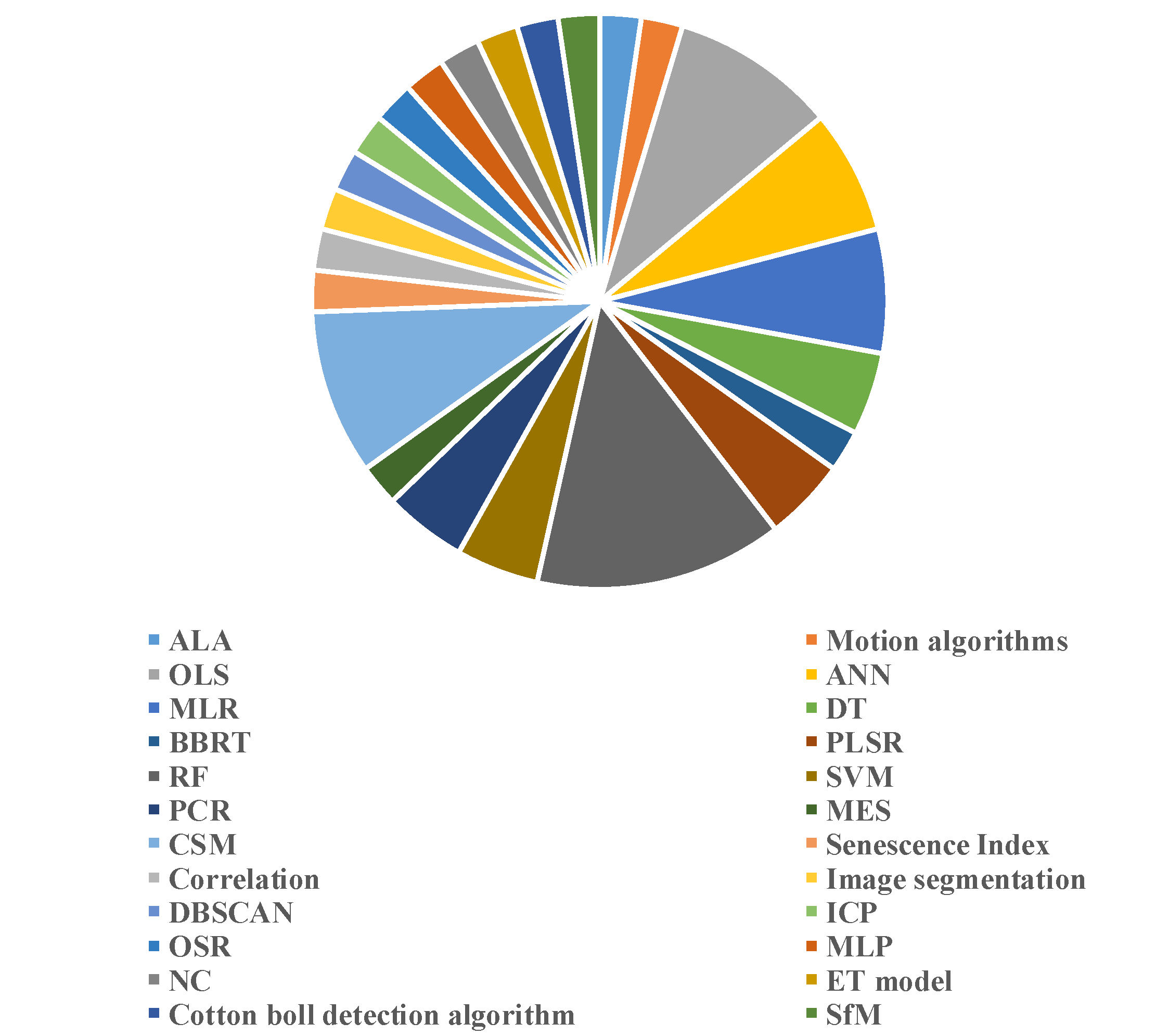
| No. | Crop | Traits | Platforms | Sensors | Methods | Reference |
|---|---|---|---|---|---|---|
| 1 | Wheat | Seed emergence uniformity | UAV | RGB | ALA | [7] |
| 2 | Blueberry | Height, extents, canopy area, volume; crown diameter and width | UAV | RGB | Motion algorithms | [8] |
| 3 | Wheat | LAI | UAV | MSI | OLS | [9] |
| 4 | Wheat | AGB | Ground | Hyperspectral | ANN, MLR, DT, BBRT, PLSR, RF, SVM, PCR | [10] |
| 5 | Wheat | Spikes | Field-based phenotype platform | RGB; MSI | MES | [11] |
| 6 | Barley | Fresh/dry Biomass | Elevated position | RGB | CSM | [12] |
| 7 | Maize | CC; Senescence | UAV | RGB | Senescence Index | [13] |
| 8 | Maize | Yield | Ground; UAV | RGB; MSI | MLR | [14] |
| 9 | Apple Tree | LCC; 3D reconstruction | Ground fixed | 3D laser scanner | ANN | [15] |
| 10 | Sugar Beet | Beet cyst nematode; yield | Handheld and UAV | Hyperspectral; Thermal images; HSI | PCR; DT | [16] |
| 11 | Eggplant, Tomato, Cabbage | Height; biomass | UAV | RGB | RF; OLS | [17] |
| 12 | Wheat | Senescence Rate | UAV | MSI | Correlation | [18] |
| 13 | Tree | Crown perimeter; width; height; area; CC | UAV | MSI | Image segmentation | [19] |
| 14 | Wheat | Height; vigor | Ground; UAV | RGB | - | [20] |
| 15 | Wheat | Height; LAI; AGB | UAV | HSI; RGB | RF; PLSR; | [21] |
| 16 | Soybean | Height; greenness index | Ground | Photonic mixer detector; RGB | DBSCAN; PCR; ICP | [22] |
| 17 | Oilseed Rape | Flower number | UAV | MSI; RGB | RF; OSR | [23] |
| 18 | Potato | Late blight severity | UAV | MSI | MLP, SVR, RF, ANN | [24] |
| 19 | Mazie | Lodging | UAV | MSI | NC | [25] |
| 20 | Cotton | WUE, FVC | UAV | MSI | ET model | [26] |
| 21 | Maize | AGB | UAV | RGB + point cloud | CSM; PLSR | [27] |
| 22 | Cotton | Cotton bolls; yield | UAV | RGB | Automatic open cotton boll detection algorithm | [28] |
| 23 | Maize | Height | UAV | RGB; LiDAR | CSM | [29] |
| 24 | Maize | Leaf length; width; inclination angle; azimuth; area; height | Ground | 3D laser scanning; 3D digitizing | -- | [30] |
| 25 | Avocado tree | Crown height; extent; CC | UAV | MSI | CSM; OLS; RF | [31] |
| 26 | Blueberry | Stem water potential; Cab; fluorescence; leaf gas exchange | Ground | Hyperspectral | MLR; PLSR | [32] |
| 27 | Barely | Height; lodging percentage; severity | UAV | RGB | SfM | [33] |
| 28 | Rice | CC | UAV | MSI | OLS | [34] |
| 29 | Cotton | Height | Ground; UAV | Nadir/Multi-Angle View Sensor | -- | [35] |
| 30 | Soybean | Height; breadth; color | Ground | RGB-D | [36] |
© 2020 by the authors. Licensee MDPI, Basel, Switzerland. This article is an open access article distributed under the terms and conditions of the Creative Commons Attribution (CC BY) license (http://creativecommons.org/licenses/by/4.0/).
Share and Cite
Jin, X.; Li, Z.; Atzberger, C. Editorial for the Special Issue “Estimation of Crop Phenotyping Traits using Unmanned Ground Vehicle and Unmanned Aerial Vehicle Imagery”. Remote Sens. 2020, 12, 940. https://0-doi-org.brum.beds.ac.uk/10.3390/rs12060940
Jin X, Li Z, Atzberger C. Editorial for the Special Issue “Estimation of Crop Phenotyping Traits using Unmanned Ground Vehicle and Unmanned Aerial Vehicle Imagery”. Remote Sensing. 2020; 12(6):940. https://0-doi-org.brum.beds.ac.uk/10.3390/rs12060940
Chicago/Turabian StyleJin, Xiuliang, Zhenhai Li, and Clement Atzberger. 2020. "Editorial for the Special Issue “Estimation of Crop Phenotyping Traits using Unmanned Ground Vehicle and Unmanned Aerial Vehicle Imagery”" Remote Sensing 12, no. 6: 940. https://0-doi-org.brum.beds.ac.uk/10.3390/rs12060940