Article

The Bus Rapid Transit (BRT) in Dar es Salaam: A Pilot Study on Critical Infrastructure, Sustainable Urban Development and Livelihoods

Institute of Geography, FAU Erlangen-Nürnberg, 91058 Erlangen, Germany
*
Authors to whom correspondence should be addressed.
Sustainability 2021, 13(3), 1058; https://0-doi-org.brum.beds.ac.uk/10.3390/su13031058
Submission received: 10 December 2020 / Revised: 6 January 2021 / Accepted: 17 January 2021 / Published: 20 January 2021
(This article belongs to the Special Issue Sustainable Planning of Urban Regions)

Abstract

:
Inner-city transportation looms large in big cities in the so-called Global South due to rapid population and urban growth. To tackle this challenge, a Bus Rapid Transit (BRT) system was implemented in Dar es Salaam (Tanzania) in 2016. This paper reports on the results of a pilot study on the impacts of the BRT on city development and livelihoods in Dar. Our pilot study, which is part of the collaborative research project LIPSINDAR (Linking Partners for a Sustainable and Inclusive Dar es Salaam), was not designed to provide a comprehensive insight into the problems of urban planning, infrastructure modification and their impact on urban livelihoods. Rather, using the example of Dar es Salaam, the study served as an entry point to highlight challenges and future research demands in the context of urban insecurities and risks in large cities of the Global South. In particular, our study investigated the BRT as an element of critical infrastructure in Dar es Salaam and probed into its impact on residents’ livelihoods, focusing on the influence of service disruptions on everyday routines, and on different stakeholders’ views on the functionality of the BRT. Elaborating on this topic, interviews, street vendor surveys and mappings were used as methods to describe the processes. To examine the results more closely, the outcome was divided into groups of different fields of activity, namely Traffic Management, Local Residents, City Administration, Basic Provision Services and Street Vendors. In summary, the pilot study confirms that the implementation of the BRT system has, in general, served to improve urban livelihoods. Reducing commuting times and enhancing access to basic services found positive results. There is, however, still potential for improvement: the bus network, in particular, needs to be expanded and the vulnerability to natural extreme events, especially flooding, needs to be addressed.

1. Introduction

1.1. Bus Rapid Transit (BRT) Proliferating in Cities in the So-Called Global South

Cities and municipalities, in particular those in the so-called “Global South”, are constantly facing new challenges and dynamic transformations. The UN Development Goal 11 for sustainable cities therefore aims to ensure adequate housing for all, to guarantee mobility, to involve citizens in the planning process, to reduce the environmental pollution caused by cities and municipalities and to develop and maintain public green spaces. Furthermore, strengthening linkages between cities and the rural areas surrounding them is to be promoted [1]. However, some of the most urgent needs for action in sustainable urban development are currently still not sufficiently considered by actors in urban planning and city administration [2]. These include resource and climate protection, the adaptation of cities to climate change, the introduction of more sustainable, quiet, climate-friendly, and affordable mobility as well as addressing research deficits regarding these issues [3]. Another significant point is the improved coordination of measures in cities and in their surrounding areas, i.e., a better harmonisation and integration of urban, peri-urban and rural policies and strategies [4]. There appear to be major research gaps in these fields in the Global South [5]. Bai et al. argue that one reason for this is that not enough data, and diverse types of data, are collected [6]. So far, the focus of urban transition has largely been on so-called developed countries. However, the outcomes of research on, and practical decision making in, e.g., cities in the Global North cannot serve as universal solutions for, and easily be adapted to, urban areas in the Global South as there are still significant knowledge gaps when it comes to (at least potentially) different or specific problems and challenges there [7]. The problem of insufficient data on mobility and infrastructure planning in so-called developing countries, in sub-Saharan Africa in particular, is also emphasized by Kinyondo and Pelizzo [8] and van Belle [9].
The rapid growth of urban populations, along with a vastly increasing global interconnectedness and dynamic environmental change, is also associated with local infrastructural challenges and effects on livelihoods [10]. Citizens and urban professionals in sub-Saharan African cities must focus on a more sustainable urban planning which includes coping with transport infrastructure issues and coming up with enhanced local transportation concepts [11]. Planning challenges include risk exposure, ill-defined aims, or lack of foresight in planning processes considering proliferating urbanisation, especially the growth of informal settlements. The design of public transport systems (which always carry with them an inherent, and as such systemic, criticality) is also confronted with the increasing need to integrate comprehensive concepts like sustainability, inclusivity and just livelihoods in urban areas, as infrastructure also has the potential to increase social injustice and spatial fragmentation (e.g., by allowing for easier access by those who have been privileged in the first place). A so-called Bus Rapid Transit (BRT) system can be a solution for high traffic volumes and congestion in large cities [12]. The Institute for Transportation and Development Policy (ITDP) defines BRT as follows: “Bus Rapid Transit (BRT) is a high-quality bus-based transit system that delivers fast, comfortable, and cost-effective services at metro-level capacities. It does this through the provision of dedicated lanes, with busways and iconic stations typically aligned to the centre of the road, off-board fare collection, and fast and frequent operations” [13]. The planning and implementation of BRT systems are supposed to be cheaper and quicker than the introduction of conventional, often technologically more advanced (and complicated) urban transport systems. Therefore, rapid transit technologies contribute to more sustainable and effective models of public transportation, and are also usually more suitable for cities with rapidly growing populations [13,14]. The BRTData integrated information platform, the result of a partnership between the BRT Competence Centre and the ITDP (Institute for Transportation and Development Policy), currently counts BRT systems in 176 cities worldwide (as of December 2020) [15]. According to Global BRTData, most cities offering BRT are in Latin America (56), followed by Asia (45) and Europe (44) [15]. The success of BRT systems in Latin America, for instance, the high-capacity TransMilenio in Bogotá, Colombia [16], was decisive for the implementation of BRTs in Africa [12]. In sub-Saharan Africa, this kind of transport system can currently be found in only a handful of cities, amongst them Lagos (Nigeria), Cape Town, Johannesburg, Pretoria and a few other cities in South Africa, and Dar es Salaam (Tanzania) [15,17].
Communicating the advantages of relatively “low-tech” BRT systems over technologically more sophisticated, often rail-bound urban transport systems is sometimes not an easy task. In the context of global metropolitan competition and marketing, city officials occasionally tend to favour “flagship" infrastructure technology which will render their city more visible on the global map of advanced, efficient, and investor-friendly cities. On the other hand, cheaper and more flexible BRTs can be promoted as innovative systems fostering a more sustainable urban development, and as viable alternatives to informal public transport operations. In a 2014 study, Astrid Wood assessed the way South Africa’s BRT systems were adopted through policies circulating as “best practices” across the world [17]. Wood found that it is often international consultants who introduce new practices into political systems (“moving policy”), but local “pioneers” who pick them up and really move the projects forward. In this policy network, described by Wood as a “messy and tangled process of policy circulation and adoption” ([17]: 1240), it is certain individuals who help realize new transport solutions. Wood’s case study is a good example of the importance of including the roles of these individual actors (such as administrative staff or public transport providers) in the urban policy space when doing research on urban transport infrastructure. As we will demonstrate below, we approached local policymakers and other urban actors in our own study, by means of qualitative fieldwork.

1.2. Tackling Urban Transportation Challenges in the Sub-Saharan Mega City of Dar es Salaam

Tanzania’s commercial capital Dar es Salaam is directly located on the coast of the Indian Ocean. With an estimated population of about 6.7 million people [18] it is one of the biggest and fastest growing cities in East Africa [19]. The population is growing rapidly and by 2030 Dar es Salaam is supposed to become a megacity with more than ten million inhabitants [20]. Mainly rooted in its historical role and strategic location as a trading hub for East African nations [21], Dar es Salaam forms Tanzania’s central transportation hub and economic and cultural metropolis. However, inconsistent urban planning and rapid, sometimes illicit land acquisition raise questions about how to manage growth dynamics in a socially acceptable and environmentally sound manner [22]. Today, around 70% of the city’s spatial expansion and transformation is happening in an uncontrolled manner and is thus not subject to, or regulated by, official urban planning [23]. A problematic area is the Msimbazi river basin, also referred to as the Jangwani valley known for the Jangwani Bridge, one of the city’s main traffic connectors. Approx. 27% of the city’s inhabitants live in this area, many of them in informal settlements. After rainfall, they frequently face heavy flooding endangering their houses, infrastructure, health, and even lives [24]. In line with the city’s heavy population growth there is a rapidly increasing demand of, and people’s dependence on, public transport whilst the transport provision and infrastructure are limited due to poor financial resources, the densely built-up area and, in general, a lack of the city administration’s capacities and capabilities. As public transportation can be considered as critical infrastructure and thus as a core element of sustainable urban livelihoods and lifeworlds, identifying ways to solve the rising problems with traffic and congestion became an increasingly urgent matter in recent decades. Therefore, in 2002 the plan to introduce a BRT system to Dar es Salaam emerged. The BRT operation finally started in 2016.
Before and during the first stage of its implementation, Matteo Rizzo [12] engaged in an extensive evaluation of the introductory phase and negotiations about the BRT in Dar es Salaam. He looked at the functionalities of the project in particular which was designed as a public–private partnership (PPP) and triggered the transition from public to private service provision in Dar es Salaam’s transport sector. The neoliberalist and diverging interests of different project initiators contrasted with concerns of local actors led to remarkable delays in the project realization. Continuous disputes circled around the bus depot area, ticket fares, compensation for residents and businesses needing to be relocated in the course of the construction works, and the involvement of Daladala operators (the “traditional” mode of public transport, largely involving mini-buses). These issues plus the lack of government support (due to worries about increasing unemployment and competition of foreign operators) led to the start of operations in 2016 only, instead of the targeted 2010. Rizzo notes that not only project management failures, but especially political negotiation issues can be identified as the main cause for delays and local resentments [12]. Research on the planned operation of the BRT system was also conducted in 2014 by Abdi Ka´bange et al. [25] and in 2017 by Duwa Hamisi Chengula and Keneth Kombe [26]. Ka´bange et al. dealt with what they call the paradoxes of establishing mass rapid transit systems in African cities, focusing on Dar es Salaam. They, too, observed conflicting objectives during the BRT implementation process, e.g., disputes about land acquisition. Due to shortcomings in the city’s land-use framework, people had occupied roadside spaces for residential and commercial purposes which were then dedicated to, or even confiscated for, BRT development. Compensation payments and formal resettlements only happened in very few cases or at questionable market value. It became evident that priorities in the arena of city planning and development were rarely matching those in the context of livelihood activities. As a solution, Ka´bange et al. suggest a more inclusive priority-setting mechanism and a better connection between stakeholders such as government, local leaders and affected people [25]. In their later assessment of the BRT’s (potential) effectiveness, Chengula and Kombe highlight positive outcomes such as the reduction of waiting and commuting times as well as fare costs as compared to the previous minibus mode (Daladala). However, the interviews conducted in the course of their study also revealed that connections between main bus routes and feeder routes need to be enhanced, and other routes to remote areas introduced [26].
In the first weeks of its operation, the newly introduced BRT already attracted over 200,000 passengers per day [27]. In 2018, Dar es Salaam was the first African city to receive the Sustainable Transport Award by the ITDP [28]. Although the new transport system has helped to increase public infrastructure functionality, it has not yet been fully adapted to the city’s massive passenger volume. Moreover, natural hazards and extreme events like recurring floods, and their cascading effects, pose a huge challenge to the bus system’s operation. The new bus system has already been severely disrupted several times, not only leading to civic protests but also facing passengers with a multitude of experienced or potential ruptures of their daily livelihood routines. This poses severe threats especially to those who must rely on mobility in order to secure their livelihoods (not only commuters in the formal employment sector but thousands of vulnerable persons in informal businesses or self-employed, such as street vendors). Malfunctioning infrastructures that hamper citizens in pursuing their urban livelihoods may even be interpreted as impeding their “right to the city”, i.e., exerting their rights by accessing city resources and shaping their urban lifeworlds by means which they deem fit or necessary. This “just city” and “right-to-the-city” dimension of urban planning, work and infrastructure has been underexplored in current research (cf. [29]) and adds to more conventional approaches to livelihoods and infrastructure issues in cities. In light of these observations and deficiencies, we designed a pilot study to quickly assess current challenges by means of a rapid on-site survey, and identify the most prominent research gaps. Using the example of Dar es Salaam, the pilot study was aimed at supplementing and updating the state of research by identifying existing challenges and not-yet-identified interdependencies between different actors and actions, with a special focus on service disruptions of the BRT. A transdisciplinary approach on critical infrastructure and livelihoods was chosen to shed light on different and diverging perspectives in the public and private sectors, and to come up with some suggestions and qualitative data for a future research agenda on critical infrastructures, cascading effects and sustainable urban livelihoods in sub-Saharan African cities.

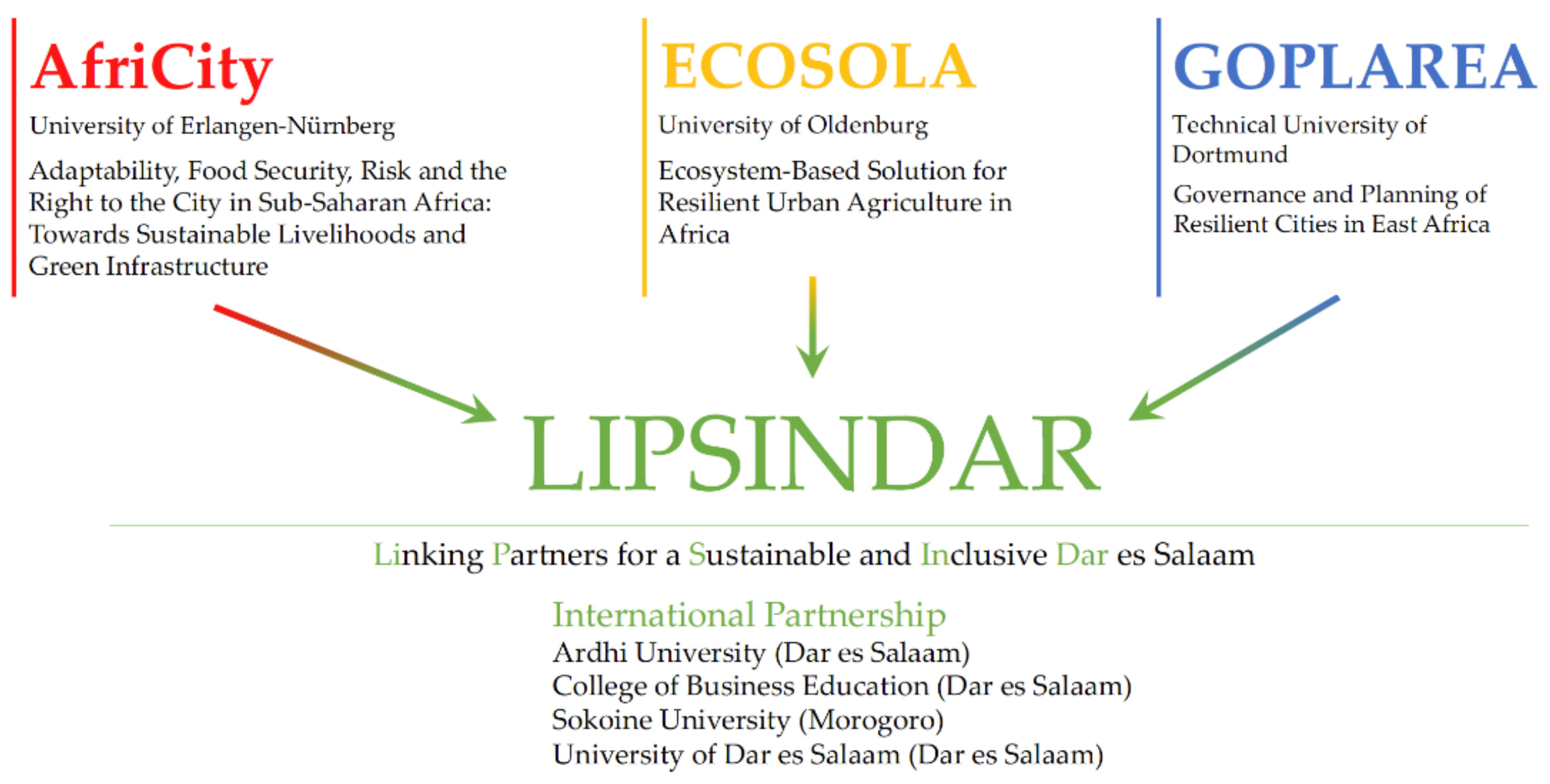
1.3. The Networking Project LIPSINDAR—Linking Partners for a Sustainable and Inclusive Dar es Salaam

The pilot study is situated within the framework of the collaborative LIPSINDAR research project, LIPSINDAR being an acronym for Linking Partners for a Sustainable and Inclusive Dar es Salaam. The project is carried out by three different consortia (see Figure 1).
The main purpose of LIPSINDAR is to create a network which links three individual research projects and consortia. The three projects are jointly funded by the German Federal Ministry of Education and Research (BMBF) and the German Academic Exchange Service (DAAD) under the umbrella of the Africa Strategy of the BMBF. The LIPSINDAR project, funded by the BMBF, connects the three projects which are stemming from different academic disciplines (Geography, Urban Planning, Ecological Economics) and are being carried out by three German universities and their African partners. The network serves to exchange research findings, to get to know each other’s disciplinary concepts and approaches, and to design joint exploratory inter- and transdisciplinary field studies. Apart from the aims mentioned in Section 1.1 the pilot study presented in this paper attempts to strengthen the linkages and cooperation between partner universities in Germany and Tanzania, with Dar es Salaam and the newly introduced BRT serving as a case in point regarding urban planning challenges, urban resilience and sustainability, and citizenship- and rights-based issues. Because the three involved disciplines (complemented by the Tanzanian academic partners who work in economics as well as urban and rural development, agriculture and nutritional sciences) usually have their specific understandings of, and conceptual approaches to, “the field”, a common thematic focus, vocabulary and methodology had to be identified and discussed before actually engaging in the fieldwork. LIPSINDAR thus triggered an intense cross-disciplinary debate amongst all involved partners.
Another aim of the project is to gather teaching, training and learning experience in multicultural contexts, and to provide university students with an opportunity to conduct fieldwork in environments they are not familiar with. The pilot study in Dar es Salaam was thus conducted by a group of Master students from the Institute of Geography at Friedrich-Alexander-University Erlangen-Nürnberg (FAU; Germany) as part of their degree programme, with support of the cooperating universities College of Business Education (CBE; Tanzania) and the Technical University of Dortmund (TU Dortmund; Germany). In this field study, we conducted an interview-guided survey (complemented by other methods of empirical fieldwork; see below) to gain an overview of the status quo of public transport infrastructure and its inter-linkages with planning activities and urban livelihoods in Dar es Salaam and, in particular, to identify the scope of threats, risks, challenges and possible cascading effects concerning the functionality and systemic criticality of the BRT. The Master students, who co-authored this paper in collaboration with their two academic supervisors, enrolled in a “research training course” which is a regular element of the Human Geography Masters programme at FAU. The course spanned over two semesters, including a 14-day field trip to Dar es Salaam in February/March 2020. Before the start of the research training course, a workshop in Dar es Salaam in June 2019 was held to discuss potential topics for the pilot study in general. Another meeting, a preparatory workshop with all partner universities, was conducted at TU Dortmund in November 2019 in order to define the focus and core research questions of the study. The results of the previous workshop in June served as a basis for these discussions. In addition, a stakeholder workshop was carried out at the CBE in Dar es Salaam a few days before the start of the actual fieldwork, organised by TU Dortmund, with over 50 participants from relevant groups of actors (City Council, BRT, Mtaa leaders/street chairpersons, representatives of Daladala mini-bus drivers and other activists, citizen representatives, scholars, etc.). A final workshop in Dar es Salaam to present and discuss preliminary study results with urban actors involved and to encourage future in-depth research on the topic had to be postponed because of the Corona pandemic and is now scheduled for mid-2021 (see Figure 2).

1.4. Assumptions of the Pilot Study

The pilot study aimed at exploring potentials of modern public transport to contribute to more inclusive cities, at identifying direct and indirect effects of this means of transport on urban residents’ everyday activities, and at pointing out research gaps that need to be addressed. Apart from considering commuting behaviours and (mostly informal) economic activities, a special focus was on the BRT’s “built-in” criticality, e.g., on service disruptions linked to, or enhanced by, shortcomings of the bus system itself. The effects of the BRT system in Dar es Salaam have hitherto not been assessed in depth, and little is known about the cascading impacts of a service breakdown. However, designed as a pilot study, and as an academic teaching and training endeavour, the survey never aimed at generating representative results on a larger scale. As mentioned above, no reliable data on infrastructure and mobility aspects are available for Dar es Salaam. It was thus not possible to revert to such data. In fact, this lack of reliable and sufficient data was one of the main reasons for conducting the pilot study in the first place: confronted by an insufficient data basis (not at all uncommon in sub-Saharan African urban environments), we had to explore new options to generate data, some quantitative but most acquired through qualitative fieldwork. Therefore, the goals of the pilot study were to experiment with several transdisciplinary concepts and tools, to probe into various parameters and processes at the transport infrastructure—urban livelihoods nexus and to hint at essential challenges. The outcomes serve as a basis and orientation that need to be explored further, and to identify opportunities and stressors to be examined in depth in a future fully-fledged study.
Consequently, the following two interconnected research questions formed the basis of the pilot study:
“Bus Rapid Transit as an element of critical infrastructure in Dar es Salaam: How does the implementation of the BRT affect residents´ livelihoods? How do service disruptions influence them?”
During prior literature research and through discussions with project partners and residents, three hypotheses emerged. For the conceptual design of the study, the LIPSINDAR project partner workshop in Dortmund and the ensuing stakeholder workshop in Dar es Salaam were of central importance. Three hypotheses lay the foundations of the fieldwork phase in Dar es Salaam.
Hypothesis 1.
The BRT is improving for urban livelihoods.
It is assumed that the BRT led to more secure livelihoods, more decent living conditions through the reduction of travel times and better accessibility of basic provision. More sales opportunities for street vendors and the creation of new jobs can also contribute to improved livelihoods.
Hypothesis 2.
The BRT has a positive impact on urban mobility.
Another assumption is that Dar es Salaam’s overall transport infrastructure is relieved by the BRT by reducing (inner city) traffic congestion and the number of cars in the streets. Separate bus lanes ensure faster traffic flow, and the structure of stations increases pedestrian safety.
Hypothesis 3.
The BRT system is prone to both externally induced and internal disruptions.
Some experts and passengers in Dar pointed out the risks and the structural faults of the transport system. Inherent flaws such as insufficient feedback loops and unclear responsibilities within the BRT organisation can trigger the risk of service disruptions as well as non-adjustment of the service to weather dependency (flood risks). The geographic location of the city on the coastal shore and at the mouth of Msimbazi river, combined with its rapid rate of urbanisation, land sealing and the effects of climate change lead to more frequent and more intense flooding in the city area, which is a major threat and, if not tackled adequately, the main cause of service disruptions.

1.5. Core Concepts and Literature Resources

The pilot study is based on two underlying concepts: critical infrastructure and livelihoods. Infrastructures are considered “critical” when they are of major importance for the functioning of modern societies and their failure or impairment results in long-term disruptions of the overall system [31]. For this study, the recently established BRT system in Dar es Salaam is thus defined as an element of critical infrastructure, given its crucial role in urban public transport. In preparation of our study, we observed that although a considerable amount of literature on BRT projects as relatively low-cost but high-capacity and flexible transport operations has emerged in recent years (see Section 1.1), their criticality has barely been considered. In our study, we focused on the mentioned disruptions of the overall, and overarching, livelihood routines, and of city logistics, triggered by failures of the BRT. It was also deemed important to look at different interconnections within critical infrastructure systems. These systems are “highly structured, complex and highly interconnected networks […]. However, critical infrastructures are vulnerable and can be damaged, destroyed or disrupted by breakdowns […], natural disasters [etc.]” [32]. Our pilot study looked at the impact of flooding events in particular, as these emerged as a major cause for severe service disruptions. The bus routes and the location of stations and depots are mainly the results of spatial planning decisions, which is why we included processes at the level of city administration in the pilot study. Collaboration and decision-making regarding use of space are primarily executed on this level [33]. In addition, the study also considered other stakeholders involved in, or relevant to, the decision-making processes.
The concept of critical infrastructure evolved from a systemic point of view, leading to the conceptual approach to so-called “systemic criticality”. According to Germany’s National Strategy for Critical Infrastructure Protection (CIP-Strategy), infrastructure contains systemic criticality when it is embedded in a functional system and is therefore connected with other services through significant interdependencies [34]. Systemic criticality is thus inherent to, for instance, electricity, information and telecommunication infrastructures, health, and educational facilities or, in this case, (public) transport. These sectors are systemically critical if “systemic feedback and cross-scale dynamic interactions” exist between them [33].
Residents, too, are elements of city-related systems (and, one might argue, form the core of cities which can essentially be seen as a social product). They experience consequences of infrastructure disruptions as their livelihoods depend on the functioning of services such as transport, electricity or water supply. As an example of a number of similar definitions, Krantz states that “a livelihood comprises the capabilities, assets (stores, resources, claims and access) and activities required for a means of living” [35]. Public transport can be identified as one of these assets. The United Nations definition of sustainable road transport, too, mentions the social dimension. Road transport needs to be developed in “a manner that is safe, affordable, accessible, efficient, and resilient” [36]. Since the late 1990s, livelihood studies have been a major field of interest in Development Studies. The concept of Sustainable Livelihoods came to the foreground as the Sustainable Livelihood Framework was pushed by the Department for International Development (DFID) and other development and humanitarian organisations [37,38]. More precisely, a livelihood can be regarded as sustainable when it is able to deal with and recover from shocks and stresses [33]. Opportunities and challenges related to successfully mobilising strategies to access, and make use of, assets to reduce vulnerability and sustain an adequate livelihood are thus at the core of the Sustainable Livelihoods Approach [38]. Therefore, disruptions in public transport and other assets of basic provision services need to be considered in order to measure the quality and security of livelihoods.
The significance of this study lies in its attempt to link concepts of critical infrastructure and people’s livelihoods, e.g., through assessing the cascading effects of extreme events (here: floods) and BRT disruptions. The main purpose of the study was to explore the impact of the BRT system on people’s livelihoods and the overall transport infrastructure of Dar es Salaam, as well as the vulnerability of the system to inherent and external stressors and disruptions. Functional and planning processes of the BRT system were evaluated as well as their impact on passengers and other dependent infrastructure sectors. In the following chapters, we will summarise some core preliminary findings of the exploratory pilot study. These provide some provisional answers to the following questions:
  • Which effects does the bus system have on people’s everyday lives and livelihoods?
  • How do certain stakeholders and groups of residents adapt in case of service disruptions?
  • Which cascading effects may emerge in case of service disruptions?
  • How did the city develop or change in light of the newly introduced BRT system?
  • How can planning processes be optimised to better prevent disruptions and cascading negative effects in the first place?
  • Are there any structural or functional differences between individual BRT system components (such as bus stops/stations) that have an influence on criticality issues?
The participatory approach of the pilot study attempted to consider voices of affected people like residents and street vendors. These complement previous research findings from infrastructural project planning, spatial planning and risk management. Key stakeholders and different actors were brought together by the pilot study. In the process of urban transportation planning, involvement of the public and of different stakeholders is essential and even inevitable. It allows for proactive planning and transparent decision-making. Additionally, as mentioned in Section 1.1, the roles of individual local actors in shaping policies and implementation strategies must not be underestimated. In the context of a “developing city” in particular, with its lack of unified institutional arrangements and reliable governance practices, coordinating and negotiating multiple interests is a challenge [39]. For the purpose of our research, this was mainly achieved by joint workshops in Dar es Salaam before and during the pilot study. The workshops were collaboratively organised by the Tanzanian and German LIPSINDAR partners.

2. Materials and Methods

The pilot study and some preparatory activities are based on the conceptual framework of the “Grounded Theory”. Due to this methodological approach and the exploratory nature of the pilot survey, mainly qualitative methods (participatory interviews and mappings, content analyses of photos, group discussions, observations) were employed for data collection. As the aim of the pilot study was to provide a rough overview of situations, locations, (critical) events and actions in relation to the BRT, urban planning, and the livelihood contexts, impressions and everyday situations related to the BRT were first collected through site visits and photo documentations (see Figure 3). This served to identify central hotspots and locations for the planned mappings and interviews.

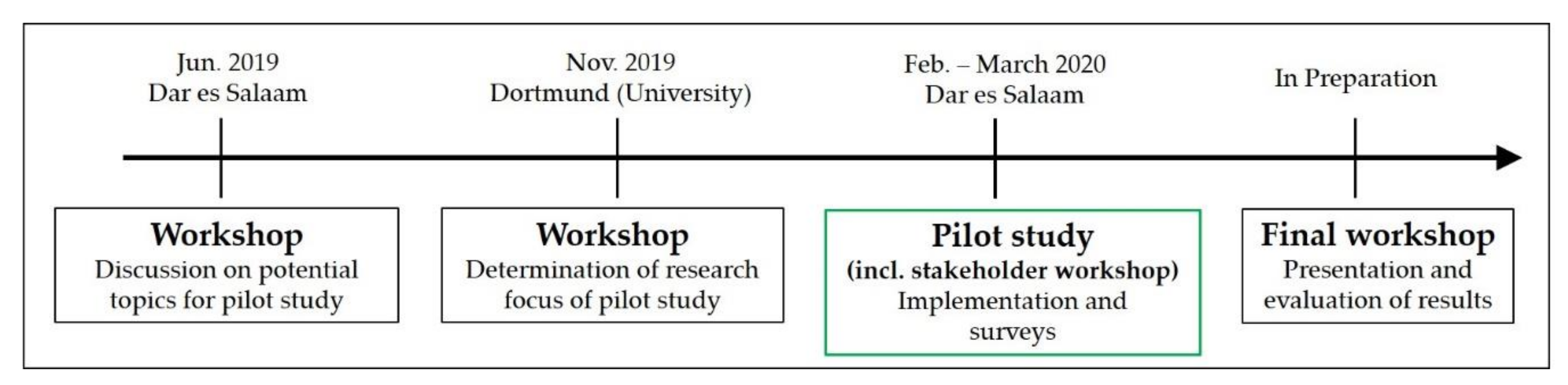
2.1. Stakeholder Workshop

The pilot study started with a stakeholder workshop at the College of Business Education (CBE) and was supervised and directed by J. Lückenkötter and P. Kruse, both from TU Dortmund. During the workshop, three different scenarios concerning the duration and severity of BRT disruptions were developed and discussed with local stakeholders. The participants were selected in advance in an attempt to include representatives from as many organisations and BRT-related stakeholder groups as possible. Stakeholders from city and municipal councils, academic institutions, public organisations, citizen’s initiatives and the private sector were invited. In total, around 50 persons participated in the workshop. For the subsequent fieldwork, the most important stakeholders were identified from amongst the participants as interview partners (see Section 2.2).
In order to approach the core topic of systemic criticality and to grasp the scope of cascading effects in case of a BRT service breakdown, the workshop participants were “confronted” with three scenarios. All dealt with effects of an assumed closure of the Jangwani Bridge. The Jangwani Bridge is part of the main BRT traffic route and serves as the fastest and most effective connection between the eastern part of Dar es Salaam, including the CBD, and the city areas west of the Msimbazi river over which the bridge crosses. The scenarios were based on the assumptions that the bridge would close for (a) one day (which happens several times a year due to heavy rainfall and flooding), (b) several days and (c) a few weeks (assuming a major flood event including damage to the bridge). The main objective was to identify cascading effects of the flood-related closure of the bridge and thus BRT service disruption on other systems, including everyday life and work situations. Workshop participants were also asked to discuss the “true” underlying causes of the disruptions and cascading effects; such causes to be found, e.g., in a poorly planned bus and road system or in a more general impact of increasing flood events due to climate and environmental change. In the course of the discussions (mostly in breakout groups), images of the extent of criticality of the BRT emerged which were then discussed in a concluding plenary session. Participants were free to comment not only from their professional point of view, but also to add personal thoughts and describe individual experiences. The scope of key findings thus covered the consequences of traffic jams and severe commuting delays on the individual family and work situations as well as on other basic provision services such as waste or emergency services.

2.2. “Expert” Interviews

With the support of the CBE, 15 interviews were arranged with people representing different organisations or interest groups. These interviewees were considered “experts” as most of them were professionals or had profound knowledge about, and interest in, the topics dealt with during the workshop. As the pilot study was not intended to generate statistically representative data but rather to identify, and test, different approaches and methods while attempting to cover as many different stakeholders as possible, within the relatively short time frame of two weeks, (potential) interviewees from a broad scope of sectors or organisations were approached but their availability in the given time frame was also a decisive factor. The majority of qualitative interviews were semi-structured. Questions were prepared in advance, but flexibility was kept through an open design, e.g., by spontaneously adding reinforcing, or clarifying, questions. The duration of the interviews varied. The majority lasted between 30 and 45 min. The interviewees were divided into four different groups reflecting the different fields of expertise: Traffic Management, Local Residents, City Administration and Basic Provision Services. Each group was linked to an individual research focus with a specific overarching research question. The interviews were conducted on the basis of the following lead questions (see Table 1).
The allocation of interviewees to one of the four groupings was based on their respective areas of responsibility, activities, or interests. For the pilot study, it was assumed that the four selected groupings represent some of the most essential spheres of influence on, or most important groups affected by, the BRT system and its disruption or criticality. The classification into groups helped to provide a clearer interpretation of individual statements but extra care was taken to not subsume specific personal views of interviewees under the more generalised group-related results.
We did not apply any specific scientific procedure for information processing of the interviews. Not all interviews could be digitally recorded for lack of consent from some interviewees. Some interviews were conducted in the national language Swahili and were then translated into English. Due to these factors, no systematic transcription was performed. Instead, key points and important statements were recorded in written form during the interviews. Afterwards, the statements served as a basis for a memory protocol which served to structure the most important contents. If available, audio recordings were compared with the memory protocols. As the last step, contents were summarized and categorized and only then assigned to the topic groups (Traffic Management, Local Residents, City Administration, Basic Provision Services) described above.

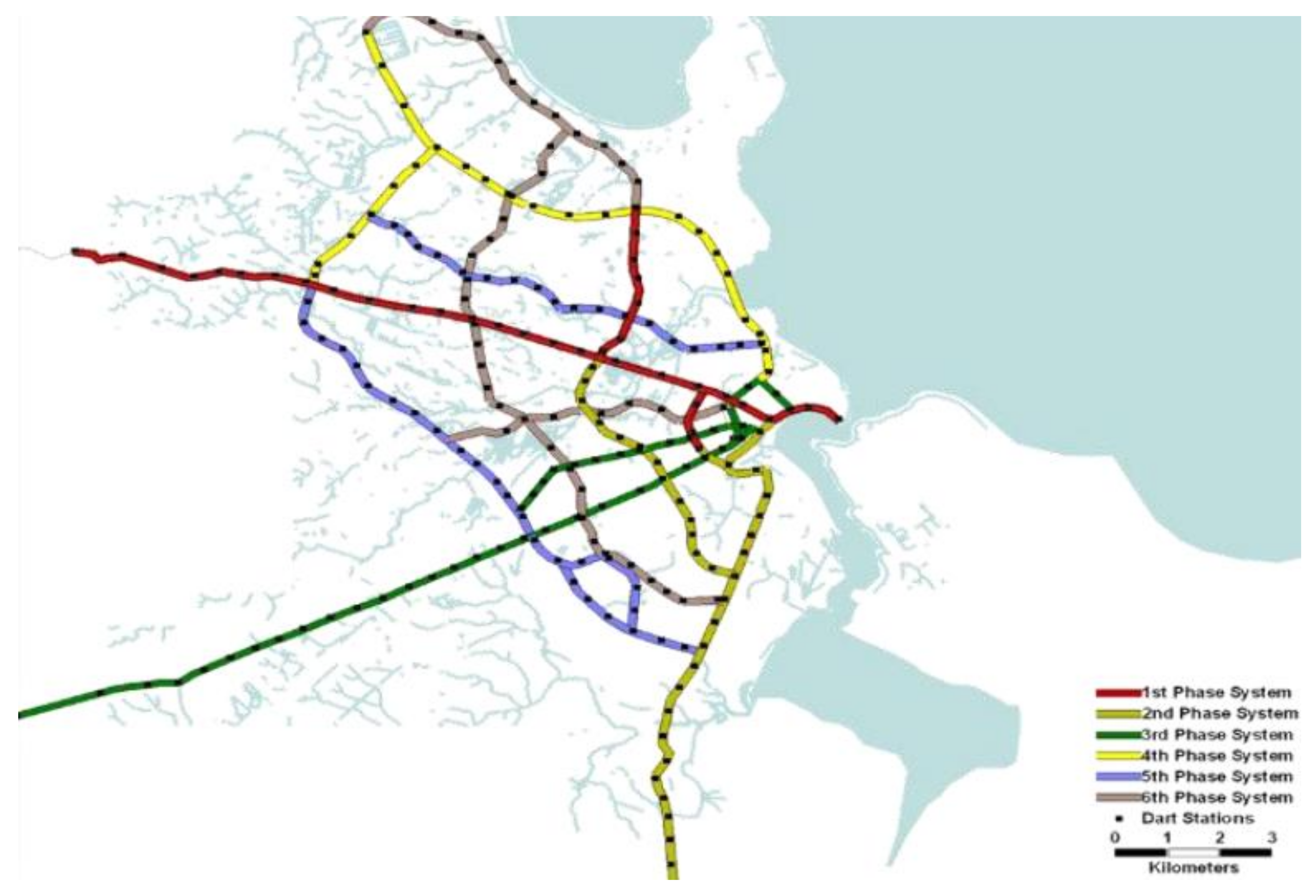
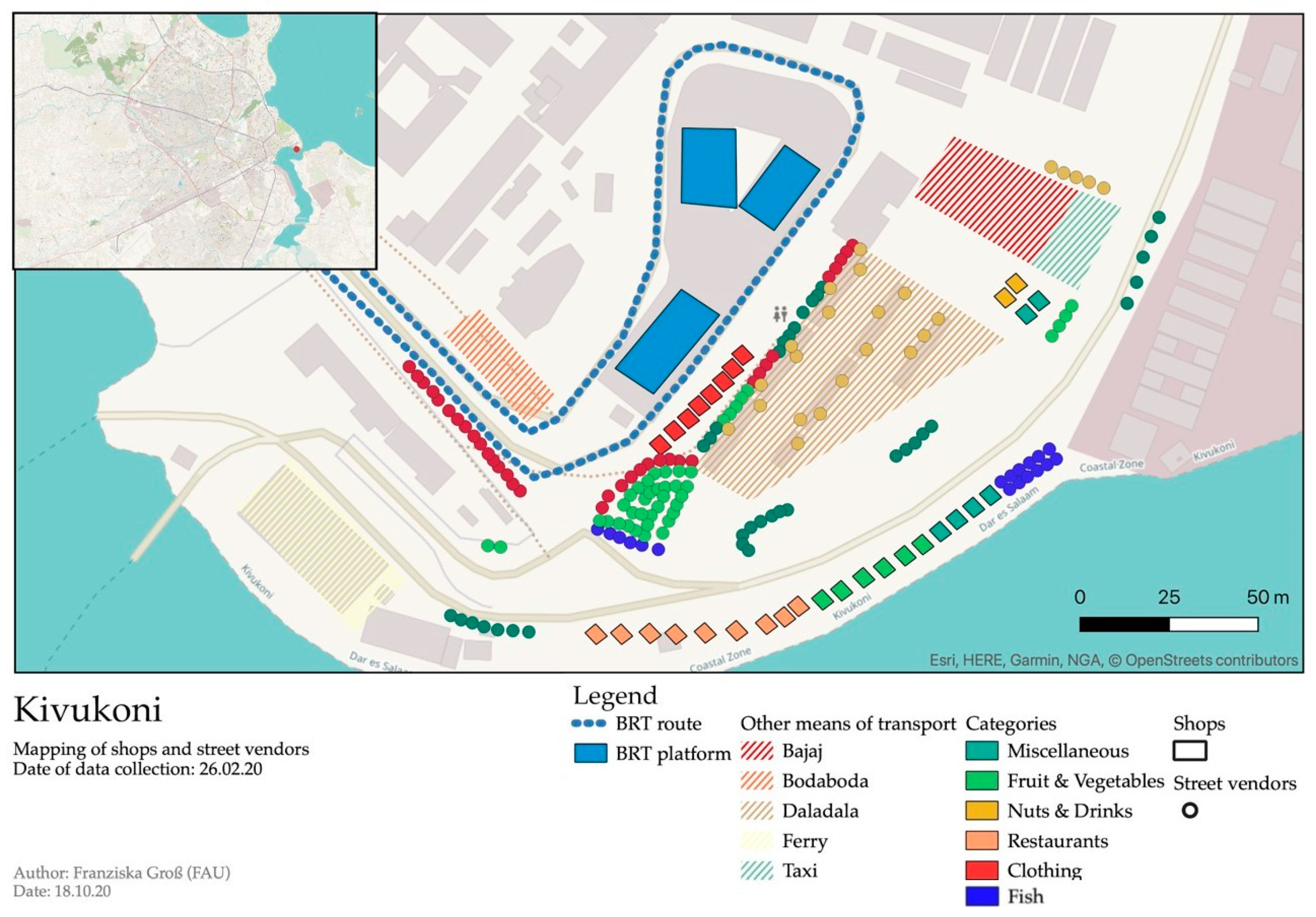
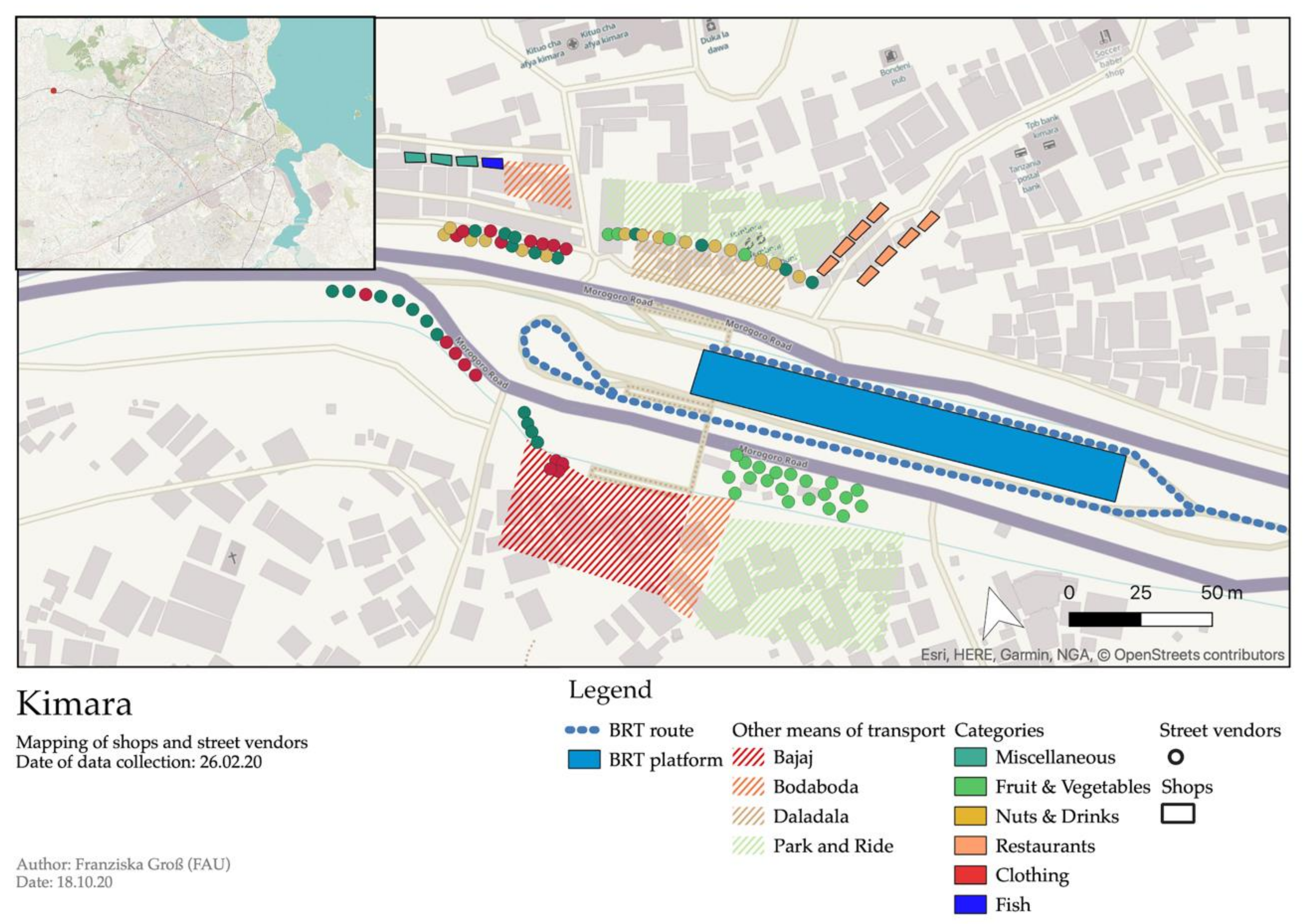
2.3. Mappings of BRT Terminals

At the beginning of the pilot study, different bus stations and terminals were mapped (see Figure 4). The main objective of the mapping was to gain a better overview of terminal structures and to identify spatial patterns in the bus stop surroundings, such as the allocation of permanent shops or temporary vendors and their product range. Furthermore, other public transport services like Daladalas (local city buses), Bajaj (auto rickshaws) and Bodabodas (motorcycles) were localized. The bus stops were selected purposely according to their location, functionality and importance within the BRT network:
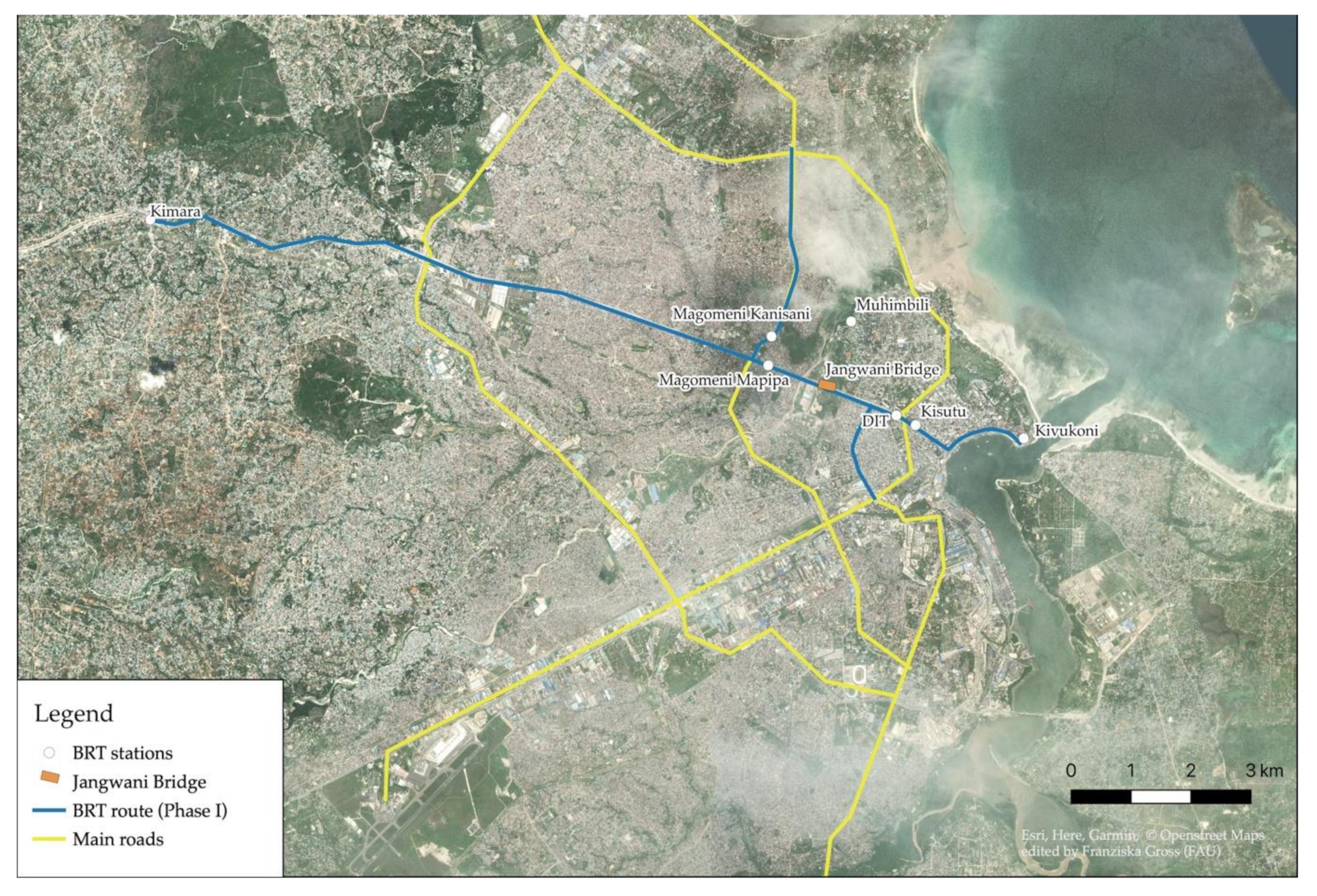
  • Kivukoni, Kimara: Both BRT stations are terminals of the BRT trunk routes. Kivukoni is the city centre terminal leading to the harbor and the ferries. Kimara is the most western BRT bus station and an important traffic hub for further travel on Morogoro Road.
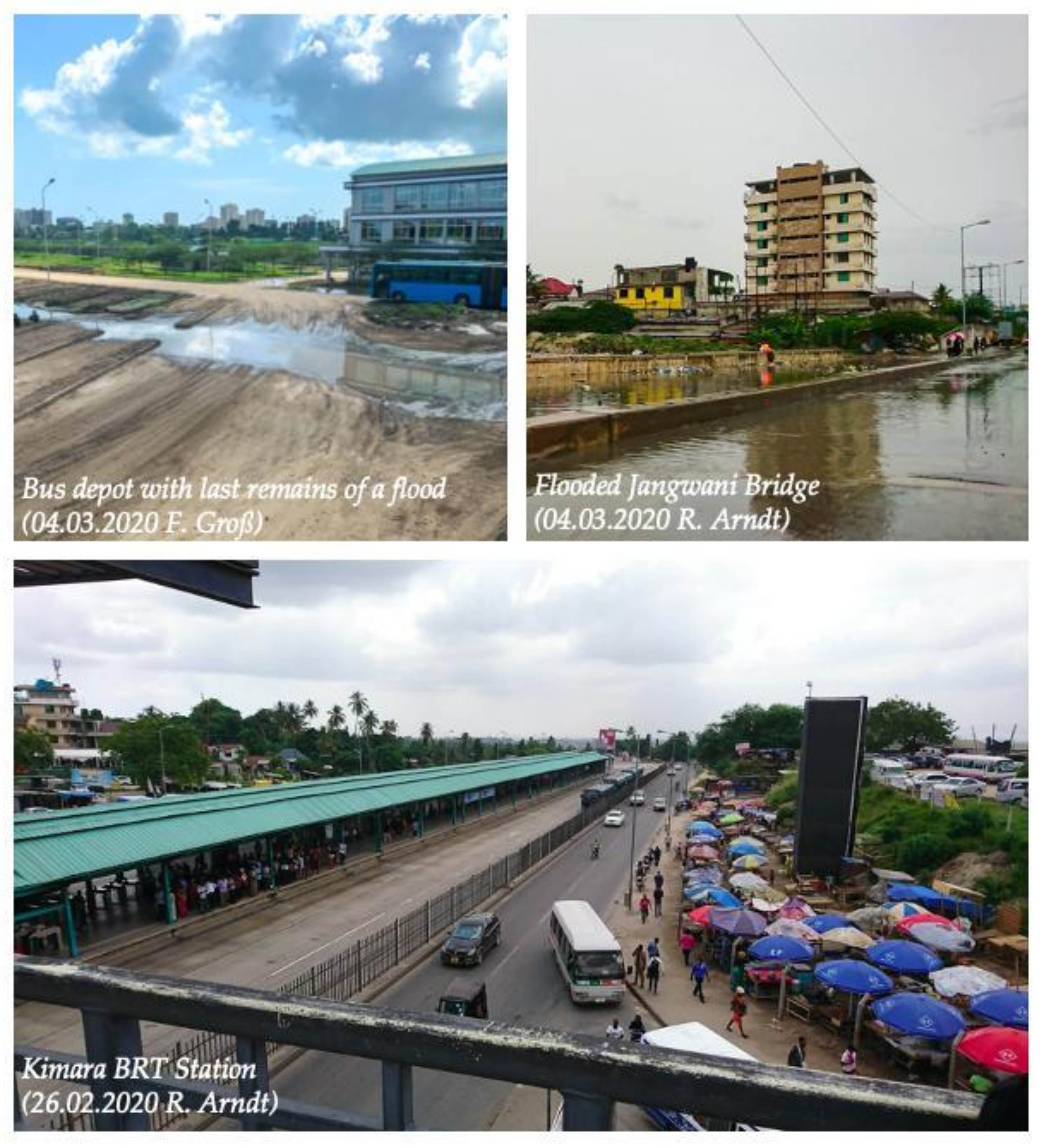
  • Magomeni Kanisani, Magomeni Mapipa: These stations represent regular BRT stations along the routes. Magomeni Kanisani is another central traffic hub. The proximity to Jangwani Bridge is one more decisive factor. Furthermore, Magomeni Kanisani was chosen as a station outside of the Morogoro trunk route.
  • Dar es Salaam Institute of Technology (DIT), Kisutu, Muhimbili: The city centre is represented by these bus stations. DIT and Kisutu are located in the central business district (CBD). Muhimbili is on a so-called “feeder route” of the BRT system and meets lower standards than bus stops on the main route (missing bus lane and no BRT platform).
Kimara as the starting terminal of the BRT phase 1 route in the West of Dar es Salaam and Kivukoni as final terminal in the East were analysed in more detail. These two stops were chosen to allow a certain comparability of relevant linkages between economic and spatial structures and their importance within the BRT route. Special features and characteristics of the two stops were identified and compared with the information provided by the street vendor surveys.

2.4. Standardized Surveys with Local Street Vendors

A total of 23 street vendor surveys were conducted at seven bus stations and their immediate surroundings (see Figure 4), focusing on the extent to which the BRT exerts an influence on their business activities. The aim of the surveys was to get an impression of street vendors’ personal experiences with the BRT and its influence on their lives, income-generating activities and profits. In contrast to the expert interviews described above, the street vendor interviews were conducted randomly and with simple and standardized questions. Although standardized questions were asked, answers were allowed to be open, and varied considerably in length and contents. The focus was not on collecting facts and figures, but on personal accounts and experiences. The language barrier turned out to be a challenge which was successfully met with the support of CBE field assistants. The interviews were conducted in Swahili, translated into English and recorded handwritten in keywords. Due to the short duration and settings on site (noise, interruptions by customers, etc.), no audio recording was used. The data were then summarized by station and interview location.

3. Results

In the following, we present the findings of our exploratory pilot study in Dar es Salaam. The findings are based on the analysis and interpretation of our mapping and interviews, which we compared and supplemented with other scientific resources. In order to ensure confidentiality, the results of the interviews were anonymised.
Table 2 provides an overview of the findings of the different groups and interview partners, with the groups´ narratives and their most important statements.

3.1. Expert Interviews

3.1.1. Traffic Management

A significant share of the Dar es Salaam Metropolitan Development Project financed by the World Bank was targeted at improving urban infrastructure, especially urban transport services [40]. After years of discussion, the idea of the BRT was initially drafted by the city council in 2007, and operations began in 2016. In the same year, a new state-owned company was established to operate and expand the system. Once completed, the new bus network will have a total length of around 137 km, implemented in six construction phases (see Figure 5) [41]. Each phase covers a specific geographical urban area. Construction of Phase I was carried out by the Austrian construction company Strabag International GmbH starting in April 2012. Phase II is expected to be completed by 2022. The planning for Phases III to VI is still pending. Five BRT lines are currently operating. Eleven feeder service lines are supposed to connect larger areas to the BRT lines but at the moment only two feeder lines are in use. Further park and ride (P + R) stations are to be built around the BRT terminals. A total of 305 buses are planned for full-service coverage.
In order to obtain information about the traffic management of the BRT, we interviewed one representative each of a private commuter bus association (DARCOBOA), the BRT bus provider (UDART) and the bus operator (DART). As it turned out, most statements referred to planning and communication difficulties during the construction and ongoing implementation phases.
As initial planning and construction companies were replaced by others, many difficulties occurred during the implementation period, which led to significant postponements of the phases. Although phase I was finished in 2015 the service could not be launched because a provider for the bus operation was still missing. At first, a consortium of private bus operators was supposed to manage and run the BRT system but could not meet the necessary requirements. In 2016, the current provider, an external private company, started operations. The buses are owned by the provider, but the operator is responsible for managing and monitoring the BRT system. For the ensuing construction phases, the responsibility for constructing the BRT lines was assigned to a state-owned construction company which got involved in the planning and design process of Phase II.
The current provider acts as an interim service provider and does not offer full-service. Out of the 305 buses planned, only 140 are currently in operation (significantly reduced at times due to water damage to the engines because of flooding of the main depot). This results in delays and high demand, most notably during peak times in the morning (7–8 a.m.) and evening (6–7 p.m.). Demand is particularly high during peak hours at the Kimara and Kivukoni bus stops due to their function as start and end-of-line points. As a solution, the current operator is searching for another bus provider to finally offer full-service.
From the perspective of the city’s private bus cooperatives, there is some criticism that the BRT is becoming increasingly competitive and is shifting the flow of passengers to the BRT. However, although the BRT system is regarded as an innovative transport service, it does not seem to have a major impact on the operation of private buses in the city. Speed level studies on urban roads indicate that public transport can be identified as the fastest mode of transport [43]. Around 3.2 million customers are using the formal and informal transport facilities in Dar es Salaam every day (however, most data are rough estimates and must be treated with some caution). Currently, approx. 180,000 people travel on the BRT daily, representing only a fraction of users ([6,27]). One advantage of private buses over the BRT is the 450 available routes which are not rigidly fixed and are therefore more flexible in case of disruptions due to, e.g., traffic congestion and flooding.
Flooding as a direct result of heavy rainfall events is a major challenge for the BRT. During heavy rainfall, the Jangwani Bridge on the BRT main line is often flooded and can then not be crossed. The providers’ office as well as the bus depot are located directly at Jangwani Bridge and are also affected by floods. In case of sudden and severe flooding, the whole area is under water within ten to fifteen minutes, with water levels reaching up to two meters. The current high-risk location of the depot (which also serves as the BRT’s control centre) leads to communication and technical difficulties in monitoring and controlling the BRT. As a part of the Msimbazi Opportunity plan of the World Bank [24] the relocation of the depot to a more elevated site (though at a more remote location) is currently being planned.
In summary, from the Traffic Management perspective, planning processes have been considerably delayed due to the lack of a provider and a reassignment of tasks and responsibilities. The high number of passengers, the insufficient number of busses operating in the system and the resulting overcrowding and delays are posing great challenges every day. Due to the current interim service which does not allow for a sustained planning process, an increase in the number of buses is not considered feasible. In case of flood events, the BRT traffic controllers are, in theory, prepared to decide on further immediate action and to pass on relevant information to drivers and passengers. However, during rapid-onset disruptions, a communication deficit between different partners and companies can be observed, which often leads to delayed procedures and reactions and highlights deficiencies in the process and communication structure of the BRT.

3.1.2. Local Residents (Mtaa Leaders)

The group of local residents includes three Mtaa leaders from the Magomeni, Manzese and Jangwani areas of Dar es Salaam, representing the residents living in these districts. Their functions, competences and responsibilities are pretty much comparable to those of “ward heads” or “headmen” in other regional contexts in Eastern and Southern Africa. In addition to effects of the new BRT infrastructure on, and interactions with, living conditions, the interviews also provided insight into flood-related challenges and the influence of higher-level spatial planning on everyday life in urban residential areas.
Positive aspects mentioned are considerable time savings, (in principle) an overall reliability, increased safety and improved comfort of the BRT, as compared to other means of transport. For instance, the average commuting time from Kimara to Kivukoni was reduced by as much as two hours during peak time. This is substantial given the relatively short distance of approx. 20 km between the two stations. This time gained is now available for, e.g., income-generating activities which interviewees particularly highlighted as a key factor in terms of securing livelihoods.
The BRT is thus an improvement, especially for residents of remote urban areas, because of the time it saves. However, the higher fare of 650 TSh (approx. 0.30 USD) per trip compared to other means of public transport is a cause for criticism. Financially disadvantaged people prefer to walk or to use other means of transport (cf. [44]). For many, however, the higher travel costs of the BRT are put into perspective again by the travel time spared. To a certain extent, congestion on regular routes and switching between several other modes of transport can be avoided. This in turn means that only one ticket needs to be purchased, which may save money. Nevertheless, transport from A to B sometimes requires detours as the BRT network is not yet fully developed. Another challenge mentioned is the limited number of buses which leads to long waiting times and overcrowded BRT stations, especially at peak times. Additionally, not all lanes on all routes are developed as express lanes. Once blocked, the alternatives for buses which then queue in the express lane, are limited. The unreliability of the system was also mentioned, especially during peak hours, when bus drivers tend to skip bus stops. Some of the interviewees stressed this lack of transparency and a general decline in customer care. Despite its predominant advantages, the BRT is not accessible to all citizens due to higher transport costs.
The danger of flooding along the main transport axis at Jangwani Bridge highlights the criticality of the BRT infrastructure. One of the Mtaa leaders explained that the BRT was raising awareness of the challenge of flooding which had so far been neglected by the city administration. The floods of Msimbazi river, previously considered a problem of the local population, now proved to be a structural challenge to the functioning of regional transport infrastructure. Our interviewees observed a significant increase of flood risk in the last decade. Due to increasing land sealing as a result of high construction activity, less water seeps into the soil. Increased surface runoff then poses the threat of flooding, especially during heavy precipitation events. In addition, the lack of effective waste management and an increase in waste dumping in the rivers make it more difficult to dispose of excess water. The challenges reach beyond problems immediately associated with the BRT: Hoping that these circumstances will force the government to react, the interviewees seek for immediate measures by the administration and a legal and fair compensation as an alternative to forceful relocation of residents to regions with insufficient infrastructure. However, in the view of the interviewees, the only action the government has taken so far is to maintain its resettlement programs that provide for the resettlement of affected residents from flood prone areas at Msimbazi river to the outskirts of Mabwepande in the north of the city. The far-off location offers no connection to markets in the city centre and thus no significant employment opportunities, and hardly any access to resources. This makes it difficult for the residents to establish new social networks. The resettlement plan is therefore rejected by the residents. In order to maintain the potentially life-securing benefits of their housing situation at Msimbazi river, in close vicinity to the city centre, some of the respondents accept socially burdening situations. Relating to the BRT service, when some transportation routes become impassable during flooding, some districts are cut off from the city centre. The resulting delays, some of them considerable, can trigger tremendous social stress situations, e.g., when parents come home from work very late or school children only return home after dark, without being able to inform their families.
In summary, when it comes to the BRT infrastructure, the Mtaa leaders representing the group of “local residents” mentioned mostly positive effects. Greater challenges were seen in the floods’ effects on other livelihood domains, and not in their direct impact on the transport system. The focus was rather on the resettlement programmes which are officially implemented to clear the areas at risk of flooding.

3.1.3. City Administration

This group consists of representatives of the municipal councils of Ilala, Ubungo, Kinondoni, the Dar City Council (DCC) and the Ministry of Lands, Housing and Human Settlements Development (MLHHSD). The interviewees mentioned both improvements and challenges regarding the implementation of the BRT system in Dar es Salaam. The interviewees noted a positive impact on the environment following the implementation of the BRT. Traffic congestion generally decreased and passenger flow improved, with the exception of some main stations like Kimara where passengers transfer between feeder lines and BRT routes or private vehicles. As also stated by the group of Local Residents (see Section 3.1.2), shorter commuting times and time savings, especially for those living far from the city centre and having to travel long distances every day, were highlighted as a significant improvement. Respondents also mentioned the improved accessibility for vulnerable groups such as elderly, school kids or disabled people, who often have difficulties accessing other means of public transport. They are in a disadvantaged position because they are either less capable of competing with other passengers for the limited number of seats or they are not carried by private bus drivers due to lower tariffs (e.g., for school children). Positive economic effects were also mentioned. Groups benefiting from the BRT are street vendors and other transport service providers such as Bodabodas who connect BRT passengers to other destinations. Moreover, the BRT system is generally considered safe by this group of interviewees because the number of accidents along the BRT route has significantly decreased and fewer crimes such as pickpocketing on buses are committed.
Some challenges within the BRT operation were also addressed, such as the insufficient and under-capacity provision of secondary services. For example, the system is operated with an insufficient number of buses that cannot meet the demand and is, again, frequently subject to long delays. This problem of insufficient provision is seen as a sign of the profit orientation of the BRT which, in the view of some of this group’s interviewees, is not primarily focusing on people’s needs. As the Traffic Management group already mentioned, providing sufficient complementary infrastructure was also seen as challenging, especially when it comes to establishing sufficient parking lots for park-and-ride commuters at BRT terminals, and space for other means of transport such as Bajaj or Bodaboda. In addition, the still low coverage of the BRT is seen as problematic, as well as missing connections to areas off the main routes. The terminals themselves could be utilized more efficiently by allowing for shopping and leisure facilities. Additionally, medical concerns were expressed, as diseases can spread more easily in crowded buses (for example COVID-19).
The interviewees also referred to numerous positive developments of the areas along the BRT lanes such as—from their point of view—the improvement of living conditions of local residents. One dimension is economic development. Municipal officials are seeing an increase in business activities along BRT corridors which also stimulated economic development. Street vendors benefit from construction work and increasing numbers of customers, but in some instances had to relocate their businesses due to safety and security concerns. Local authorities are still negotiating the regulation and future operation of these informal businesses. As a result of the construction works along BRT corridors, changes in urban settlement patterns can be observed. As more and more people move towards the BRT corridors, population density increases. Formerly residential areas are being transformed into mixed quarters with commercial use.
Gentrification is another major challenge. Officials observe a significant increase of land value along the BRT routes, leading to in-migration of better-off people, at the cost of those who cannot afford the higher prices and have to move away. This hints at rights-based issues and problems of injustice (as addressed, in the global political agenda, by SDG 11). Urban planners in Dar es Salaam are indeed aware of these problems and attempt to decelerate gentrification in order to ensure city dwellers equal access to the dynamic urban areas along the BRT. However, lacking suitable legal and planning instruments, and with only insufficient capacities and resources, tackling this challenge remains difficult.
As most other stakeholders we interviewed, the interviewees from the city administration, too, addressed the service disruptions of the BRT. Long and frequent delays can result in higher transport costs and loss of income or revenue if people cannot reach their destinations or get to work on time. In addition, problems within families can arise if family members do not return home until very late in the evening. If the disruption is caused by flooding and the Jangwani Bridge cannot be passed, the alternative route to enter the city centre is via Selander Bridge. This is a huge detour and thus not attractive for many passengers due to the considerably longer travel time.
Respondents also addressed stressors beyond transportation. Flooding causes serious waste management issues. In the event of flooding, trucks collecting waste from the markets have severe problems reaching the landfill which is located outside the city centre. The flooding of course also seriously affects informal settlements located directly along the river. Destruction occurs almost on a regular basis now, with some buildings so badly damaged that they become uninhabitable and have to be demolished. The (mostly informal) settlements in the Msimbazi river valley are usually not legally approved because the inhabitants can often not produce ownership certificates, or do not even possess land rights. The Msimbazi Opportunity river valley development program [24] aims at mitigating the flood impacts on the infrastructural system and settlements located along the river.
The municipal representatives highlighted the need to consider the problems encountered in Phase I of the BRT scheme in the upcoming extension phases. The need for long-term solutions was emphasized, as well as expected improvements along with the project of the Msimbazi Opportunity plan [24] and the proposed development of Ubungo as a second city centre and business area to alleviate pressure in the CBD. Furthermore, the need for investments in the service delivery was highlighted as a key element for the future success of the BRT.

3.1.4. Basic Provision Services

Further interviews were conducted with representatives of basic provision services, in our case the health sector and food supply. One interview was held with an employee of Muhimbili National Hospital (located in the neighbouring Jangwani valley) and the other with a staff member of Kariakoo Market, a major market located in the city centre. Again, the main issues were related to the “weak spot” Jangwani Bridge on the logistically relevant axis of the Morogoro Road. Overall, the accessibility for customers, patients and employees in the catchment area of the hospital and the market, which have been significantly expanded, has improved. In the event of flooding, however, both the hospital and the market are difficult to access.
The BRT lanes, which are generally restricted to buses, can also be used by ambulance and rescue vehicles, thus considerably reducing the emergency response time. Accident sites can thus be reached more easily, and patients can be taken to hospital more quickly. Although the BRT system has contributed to a reduction in road accidents, the bus stops themselves turn out to be accident-prone spots, as overcrowding and congestion often trigger dangerous situations, during rush hours in particular. Again, insufficient and unreliable timetables (a problem mentioned by all other interviewees, too) lead to long passenger queues at the hospital bus stop. Although Muhimbili bus stop was supposed to be adapted to the hospital´s needs, e.g., by granting priority to boarding and disembarking for sick and physically handicapped people, this has not yet been realised. The patients, who still get stuck in the crowd, are not given priority and run the risk of further injury. The Muhimbili bus stop is part of the BRT feeder route but does not meet the regular standards of stations defined by DART and is merely a Daladala stop. No ticket machines or waiting facilities have been installed, nor has a separate bus lane been established. As a result of all these factors, the additional bus stop has not improved the boarding situation for physically impaired or handicapped patients. As described by the interviewee, the accessibility of the emergency unit by ambulance is “a disaster” and the “sometimes even bizarre traffic chaos is observed like a movie”.
The whole situation worsens dramatically during the rainy season. The station does not provide a shelter from the rain, and is difficult to reach, even for buses. If the BRT system collapses because of the flooding at Jangwani Bridge, the entire hospital is more or less cut off from its catchment area, as patients and staff have little other possibility to reach the hospital during floods. Many residential areas in Dar es Salaam are directly affected by rising water levels, leading to the spread of diseases such as cholera and malaria. Therefore, the hospital is reaching the limits of its capacity, and the lack of accessibility and insecurity of supply is leading to cascading effects such as lack of medication or unavailable staff. In addition, the geographical location of the hospital within the Jangwani basin provokes flooding in parts of the hospital area, e.g., the pathways and roads on site. Walls surrounding the area have already been built as a mitigating measure.
Some of the issues mentioned above have also been raised by the representative of Kariakoo Market, arguably the inner city’s largest and busiest market. The main hall, together with the surrounding streets, is the main shopping area for food, household goods and clothing, so the location is crucial in providing basic goods to citizens. The market has always been a very busy and crowded place, so the changes brought about by the introduction of the BRT are not significantly noticeable. Nevertheless, accessibility for customers, salespeople and employees has improved, and the market catchment area of customers has also expanded.
Here too, during the rainy season and in the event of flooding, accessibility is being limited. Many customers and vendors live outside the city centre, so that closing of Jangwani Bridge leads to long travel times to the market or even makes it impossible to reach it. Even local residents are prevented from entering the market hall because the area surrounding the elevated building is flooded. Again, this proves to be a stressor reaching beyond the mere transport dimension. During this time, the decline in customers leads to a closure of many shops, resulting in a loss of revenue of over 70% at the Kariakoo Market.
In terms of basic provision services, the BRT has had many positive impacts. Nevertheless, some structural issues remain. The construction of additional bus lanes and a consideration of those impacted is desired, as is the proper development of the hospital bus stop. Special attention to connecting Muhimbili Hospital to the public transport system can lead to improved access to health services. The current transport network is considered insufficient to include customers and patients from more distant districts. Customer catchment areas are often reaching far beyond the end points of the bus routes.

3.2. Mapping of Bus Terminals and Street Vendor Surveys

The results of the mappings will be combined with the statements of the street vendors to gain a better overview of spatial patterns and developments in the areas of the BRT stations. The terminals at both ends of the main route (Kivukoni and Kimara) are used as reference examples for the current status (Figure 6 and Figure 7). The statements of the street vendors complement the assessment of developments and changes of several stations on site. In addition to the BRT platform itself, other means of transport and the range of goods offered by the vendors were covered by the mapping. The retailers were categorized into (mobile) street vendors and fixed sales stands.
At Kivukoni bus stop, there are many fixed stalls in the immediate vicinity of the entrance and exit area and on the south-eastern side facing the coast (see Figure 6). At the Bajaj departure points, snacks, fruit and drinks are mainly offered for sale, while along the roads leading to the terminals, mainly clothes are sold. The sale of fish is also dominant due to the proximity of the fish market. Because of the fish market and the harbour, Kivukoni has always been a busy place with many street vendors. This is mirrored by the large availability of Bajaj, Daladalas and Bodabodas as depicted in Figure 6. Furthermore, the construction of the BRT system was an additional pull factor for street vendors and led to even more stores and stalls. The overcrowding of the place prevents the development of parking areas for cars and other modes of transport.
Opinions of the interviewed street vendors about the influence of the BRT on their businesses differ. Many vendors had already been on site before the introduction of the BRT because of the high customer flow at the harbour. Therefore, these vendors did not notice any major changes. Others have moved their sales locations to Kivukoni because of the BRT. The station at Kivukoni terminal is not very susceptible to disruptions caused by flooding, so the flow of sales is not disturbed, which is another advantage of this location.
Compared to Kivukoni, Kimara provides a larger transfer area for other transport services such as Bajaj, Daladalas or Bodabodas and parking lots for Park and Ride (see Figure 7). Kimara has always been an important transport hub, connecting the city centre to the suburbs by other means of transport that act as feeders. The BRT terminal station of Kimara is completely fenced, so there appear to be only a few street vendors in its immediate vicinity. At the large Bajaj stop, mainly fruits and vegetables are sold. Most of the permanent stands are located around the Daladala departure points. The establishment of the BRT terminal has intensified Kimara’s role as a suburban centre and has led to an increase in the number of street vendors along Morogoro Road. They are mainly concentrated at the western part of the terminal and offer clothing and miscellaneous items such as sweets and snacks. In Kimara, street stalls rather than fixed shops dominate. Only a few fixed shops, which mainly sell fruits and vegetables, are located towards a large market north of the Kimara Terminal.
The city centre stations like DIT, Kisutu and Muhimbili have always been lively places due to nearby facilities such as the hospital, colleges/university and food markets. Because of other customers such as students, BRT users do not represent the majority of clients in the area of the stations. Most of the street vendors tend to live in the suburbs and travel long distances to their shops in the city centre on a daily basis. In comparison, street vendors at Magomeni Mapipa and Magomeni Kanisan stations live close to their shops. The business for street vendors at these intermediate bus stops has stagnated since the implementation of the BRT and the subsequent restrictions on street vending. It is generally prohibited to sell goods within or in the immediate vicinity of the access points to the BRT stops. Thus, passengers of the BRT are generally not reached as customers. The main customers for street vendors in this area are users of Daladala and Bodaboda.
The livelihoods of street vendors are characterized by great uncertainties, as their predominantly informal sales activities are depending on daily demand and political restrictions. In addition, some vendors were evicted from their former “regular” locations because of the construction of stations, buildings and related restrictions on street vending. As noted by some interviewees, the number of street vendors in Dar es Salaam has, nevertheless, increased significantly in recent years. To keep track of the approximate number of street vendors, officially registered street vendors must pay an annual fee in certain streets where they operate. Due to the high percentage of unlicensed street vendors, the official number can only offer a fraction of the total number. Unlicensed street vendors are tolerated during election years, but their situation may change after elections.
In summary, a wide range of goods is offered in the immediate vicinity of the BRT stations and their surroundings offer attractive and new sales areas for street vendors. Despite political restrictions, fences and controls for sales in nearby areas of the BRT stations, the number of street vendors with a remarkably diversified assortment of goods has obviously increased in recent years. Opinions on the degree of influence of the BRT vary according to the station and location of the street vendors’ businesses. Although some positive influence of the BRT on business in inner-city locations such as DIT or Magomeni can be observed, Kimara shows opposite effects. The development of attractive sales areas as a part of the BRT implementation has created a kind of suburban centre and new sales hotspots there. Even at Kivukoni, where many sales stands were already there before, more shops have been established since the BRT implementation.

4. Discussion

In this chapter, we test the hypotheses we put forward for their validity, using the findings of our empirical research. The intention is to summarize the results of the pilot study, including a debate of the interview data described above.
Hypothesis H1.
The BRT is improving urban livelihoods.
On the basis of our field study findings, it can be confirmed that the implementation of the BRT system has, in general, brought about an improvement for urban livelihoods of many residents. Members of the various interview groups agree that the infrastructure system is having positive effects on the residents of Dar es Salaam but also causes criticism.
Unfortunately, the BRT system has not yet been able to reach its full potential due to some structural flaws. The low number of functioning buses leads to overcrowded buses and long waiting times at most bus stops. Nevertheless, the BRT is considered to save time compared to other transport options. This is reflected in shorter commuting times on the main BRT routes, as previously reported by Chengula and Kombe [26], especially to workplaces and educational institutions. In terms of urban livelihoods, these time savings lead to an expansion of time for economic activities and reduce stressful situations in families. In general, an improved public transport system “enables the multiple social connections and interactions that flourish within an urban space and leads to the different levels of cohesion of the multiple parts” [45].
Compared to other means of transport, the BRT buses also provide easier access for vulnerable people like children or elderly and, therefore, contribute to the inclusiveness of the transport infrastructure, as mentioned by Traffic Management and City Administration. Relating to a political agenda framing, this also supports SDG Target 11.2, which aims to improve access for vulnerable people [1]. The social aspect is an important objective of measuring the sustainability of a road transport system [46]. However, in the case of Dar es Salaam, most stakeholders argue that inclusivity should play an even bigger role in the new bus system. Currently, the BRT in Dar can only be used to a limited extent by handicapped and physically impaired people who have little chance of getting on crowded buses. In addition, because of the higher fares of the BRT some residents prefer to use other means of transport or even walk rather than using the new busses. The results of our pilot study also hinted at the importance of an appropriate fare structure; some interviewees certainly indicated that they expected the BRT fares not to be much higher than those of private operations in order to not exclude low-income residents from using the new bus system. While a more in-depth study on this issue is necessary for Dar es Salaam, the connection between income and BRT use was also investigated by Vermeiren et al. 2015 in their case study in Kampala in Uganda [47]. They determined that local BRT prices were not adjusted to all income classes and therefore the poorest segments of the population could not afford this mode of transport. For many residents, transportation costs take up a large portion of their daily disposable income, forcing lower income groups to walk or find cheaper means of transport [47]. Experiences from South Africa have led to a new approach based on hybrid systems linking BRT and minibus-taxi (MBT) operations. The BRT, which was implemented for the 2010 Football World Cup in several urban centres, could not meet city-wide demand. Access was thus not provided to all groups of residents, both in terms of costs and area coverage. MBTs, supplementing the newly introduced BRT, offer cost advantages and can operate effectively at lower utilization rates. This allows better access for lower-income populations as well. They also offer greater flexibility in their routing, allowing them to fill gaps in the BRT network area [48].
Expectations of the BRT system in Dar es Salaam are high and have led some urban residents to decide to move to the suburbs. Others were forced to leave their settlements to give room for the bus corridors [12,25]. This migration causes a dependency on the BRT system. In another spatial–social domain, the BRT is stimulating gentrification of areas around bus stops, and thus triggering a potentially unjust and therefore unfavourable transformation of urban settlements. Due to the new role of the bus stops as hubs, those areas are becoming increasingly interesting for investors, which leads to a changing land market, the upgrading of urban areas and the displacement of low-income residents from their settlements. Additionally, some areas are transforming from mostly residential to commercial areas, with still unclear positive or negative effects for residents and other stakeholders.
Furthermore, the BRT is influencing the economic possibilities. By staging the bus stops as local hubs, street vendors are able to find more locations for their business with good sales due to an increased number of passengers. Nevertheless, street vendors remain dependent on unreliable political decisions. Newly established companies such as DART and UDART (bus operator and provider) also create jobs, especially for salesmen at bus stops, bus drivers or in the administration sector.
Another crucial consequence is that the BRT affects the living conditions of the residents as service disruptions due to flooding in the Msimbazi river valley also raise attention and awareness of risks for settlements along the river banks. This has an indirect positive impact on the residents’ living situation and their livelihoods, as their problematic housing situation and the floods’ impacts have become a public issue. Previous activities, such as evictions and resettlements, have not been able to significantly improve the living situations.
Concerning urban livelihoods, a general improvement can be observed, although the system unfortunately still has many gaps and weaknesses. These have triggered a broad scope of scepticism and criticism but if the shortcomings can be eliminated in the following phases of the BRT enhancement, the new bus system has the potential to become an important element of liveability and sustainability in Dar es Salaam.
Hypothesis H2.
The BRT has a positive impact on urban mobility.
The BRT system in Dar es Salaam aims at overcoming the traffic chaos that has been increasing tremendously for the past two decades. The BRT has definitely contributed to reducing congestion on main traffic routes and improved the traffic flow in and out of the city.
The design of the new BRT is well reflected in its separate bus lanes and in the layout of the bus stations. This specific design is fairly well adapted to traffic-induced stressors and the passengers’ needs (but not for handicapped passengers; see above): Due to their location between the bus lanes, it was necessary to extend pedestrian paths and pedestrian crossings. This clear structure has significantly reduced the risk potential for accidents at those places. However, other means of transport were not included in the BRT design, which is observable in the missing parking zone for those. This can significantly impair pedestrian safety. For example, Bodabodas mostly wait for customers on pedestrian paths at the roadside.
Furthermore, a moderate (but still insufficient) expansion of park and ride areas near the bus stops took place, to facilitate commuting. Feeder lines were extended to call at BRT stations. This helped to expand the BRT catchment area. Nevertheless, the current expansion of the park and ride areas and the feeder lines is not sufficient to connect every potential user equally to the system. It is obvious that residents living close to the bus lines benefit most from the implementation. As already noted by Chengula and Kombe [26], there are no direct links between certain urban areas, which forces people to take large detours when travelling only by BRT. Another problem is that feeder lines do not meet the standards of main lines. Although the feeder buses are running, they are exposed to traffic jams because there are no separate bus lanes. On feeder routes, travel times have thus not been cut after the introduction of the new buses. Commuters expressed their strong desire for an extension of the BRT system, including the construction of many more park and ride areas and feeder lines for sustainable urban development. Linking back to Hypothesis 1 above, an expansion of the BRT coverage to areas with a high concentration of poor residents would increase the accessibility of infrastructure systems and enable more people to benefit from the better connection to the economic centres. This way, the BRT would contribute to the reduction of spatial and social inequality in the city. This argument is supported by the recent work of Oviedo, Scholl, Innao and Pedraza, with their study on linkages between BRT and job opportunities in Lima [49].
Emergency services as well as accident victims and patients in need of rapid medical care benefit from the extension of bus routes and separate bus and emergency lanes. By using BRT lanes, ambulances and fire brigades can pass the city traffic and reach their destinations more quickly. While important, this is only a small positive side effect of the new bus system—in general, accident and emergency responses are in urgent need of a thorough infrastructure overhaul. At Muhimbili Hospital, for instance, the separate BRT lane has not yet been completed, let alone an easily accessible emergency entrance installed, so the ambulances have to use the normal roads and may be hampered by traffic jams.
Overall, a further expansion of the BRT system is necessary in order to eliminate the current challenges and problems for users. It should be noted that the expansion of the system is still in its initial phase (Phase I of a total of six phases) and therefore a comprehensive transport network has not yet been developed. However, along with the expansion of the BRT network, it becomes clear that public transport infrastructure can play a vital role in contributing to a more sustainable and just city development. Its (potential) contribution to achieving the SDG 11 can clearly be observed, with the BRT in Dar, despite its shortcomings, already facilitating transport for many urban dwellers. The BRT can be considered one step on the pathway towards accessible infrastructure for everyone, and it does support a closer connection between urban and rural areas [1].
Hypothesis H3.
The BRT system is prone to both externally induced and internal disruptions.
With regard to its vulnerability, externally induced disruptions on the BRT system caused by extreme events are particularly relevant. Jangwani Bridge, connecting the city centre with surrounding residential areas, turns out to be the biggest challenge and bottleneck for the public traffic infrastructure network in Dar es Salaam [50]. During the rainy season, the water level of the river usually is only a few decimeters below the bridge, so that even average rainfall events flood the bridge and render it impassable [24]. In this case, traffic has to be diverted to smaller bridges, resulting in enormous traffic chaos in the city centre. The dependence on the weather and exposure to extreme events reveals a major weakness of the BRT system. It also puts the whole BRT infrastructure (including its equipment, headquarters, etc.) at risk.
The pilot study identified an inadequate early warning system and an unreliable information flow as important elements of “internally” generated disruptions. The existing early warning system is not sufficient to prepare for imminent flooding, and the poor dissemination of information results in a lack of buses and in extremely long waiting times for passengers. Another internal BRT difficulty is the location of the BRT bus depot in the Msimbazi river valley next to Jangwani bridge. The bus depot was set up there to be able to respond to capacity leaks by quickly feeding in more buses should passenger volume demand this (especially during peak hours). Since the bus company is forced to remove buses from the depot and park them safely at elevated locations during rainy events, further tensions arise. In order not to be exposed to this recurring situation in the future, the bus depot will be moved to Ubungo, far out of the city centre, during the next construction phase. Yet, the more remote location of Ubungo does not offer the same opportunities for quick response. However, involved actors hope to resolve the most urgent problems and the tensions that had already arisen when the depot was constructed at its current site [12], by relocating it.
The complexly woven network of companies involved in the BRT system does not assign clearly defined areas of responsibility. Competences and responsibilities are constantly shifting between different actors. In particular, the “who-is-to-blame” debate concerning the poor planning at Jangwani bridge causes unrest and also leads to a paralysis in the search for a solution. Whilst the inter-woven organizational structure of the BRT system cannot be overcome easily, a network reconfiguration is being examined as one potential way to tackle the challenges described: establishing alternative routes to keep the buses going in flood events or in high traffic is considered as one feasible solution, turning the BRT into a more redundant transport system. Informal transport facilities, which are generally more flexible in their routes and timetables, help to relieve the overcrowded system in case of disruption but their systemic integration into the BRT is difficult.
Solving the problem concerning Jangwani bridge seems essential. Here, the World Bank’s Msimbazi Opportunity plan [24] will hopefully minimize the risk of flooding in the future. The plan outlines first approaches to solve the problems, e.g., by elevating the bridge. However, some difficulties still need to be resolved before implementing the plan. The informal settlements in the river basin would have to be relocated as they are increasingly frequently threatened by floods, on an almost annual basis in the last decade (2009, 2010, 2011, 2014, 2015, 2017, 2018) [24]. Furthermore, there are community facilities located in the valley and their continued existence in this location needs to be evaluated. In summary, the BRT still has many hurdles to overcome in order to sustainably improve Dar’s transport system. In 2020, at last, first concrete steps have been taken to prepare for a more long-term solution. Plans are on their way to regularly remove alluvial deposits from the riverbed which would improve the situation considerably, reduce vulnerability to rainfall events and flooding and thus allow to focus on further challenges. However, internal negotiations between BRT actors to better allocate tasks and “streamline” the organisational structure of the network should be considered a precondition for other measures to work.

5. Conclusions

The following section aims at outlining our conclusions in light of the two leading, inter-twined research questions (see Section 1.3), and to critically reflect on the pilot study as such.
Regarding the impact of the new BRT on residents’ livelihoods, we conclude that the introduction of the BRT system has indeed helped to create a lot of new jobs and generated more income opportunities (e.g., for street vendors). The most direct positive outcome of the BRT does, of course, relate to its immediate function as a public transport facilitator: The BRT’s major advantage is the considerable reduction of commuting times, especially to and from the city centre. The BRT has also, in principle, increased inclusivity for urban residents, including some disadvantaged groups, as many of them can now more easily access the transport infrastructure. Once extended to its full projected network, the BRT certainly has the potential to ease the notorious traffic burden in Dar es Salaam, which will have an overall positive effect on the urban residents’ daily lives.
One of the current main challenges of BRT is its relatively slow implementation. Only the first of a total of six construction phases has been completed so far. A rapid expansion, with a much-increased number of buses and further feeder routes, is urgently required to provide full access and to meet the high demand for adequate transport. In addition, albeit in principle offering better travel options for many urban dwellers, the BRT is not yet equally accessible to all residents due to its comparably higher fares, which exclude certain residents from the benefits of the new transport infrastructure. The most prominent challenge, however, comes with the service disruptions due to flooding in the Msimbazi river basin.
The frequent flooding of the estuary area, especially during extreme weather events, poses a severe threat to local settlements and their inhabitants. BRT service disruptions, however, are probably the most frequent, and directly “visible”, consequences of such events as thousands of bus travelers are immediately affected. As these disruptions are publicly discussed, they reveal and unpack underlying problems in the residents’ living conditions, in unclear settlement issues and poor urban planning processes. In our pilot study, most respondents were fully aware of the scope of cascading effects the service disruptions had on transport facilities, urban mobility in more general terms, and daily routines and residents’ livelihoods. In this respect, however, we found that many respondents somewhat underestimated the importance of robust and constant communication links between the urban actors involved, such as government, local leaders and citizens. In fact, the stakeholder workshops conducted before and during the pilot study, and the interviews, proved to be the first opportunities for many stakeholders to meet, voice their experiences and concerns, and discuss challenges and potential solutions with others. Therefore, we deem additional studies necessary about how to further improve planning structures and generate more sustainable solutions beyond the immediate scope of public transport issues.
The BRT is a good example of how inter-dependencies of different stakeholders, and their fields of action, manifest within the transport sector but expand into the economic and social sphere as transport connects citizens to their income-generating activities and basic services. In consequence, the participation and inclusion of previously hardly connected residents is at stake. Their ability to use these services is impaired by disruptions. Dependency on the new BRT will increase once phases II and onwards are completed, granting hundreds of thousands more potential passengers’ access to the new service. The BRT is thus more and more developing into an element of critical infrastructure (see Section 1.5). It must thus be assumed that unless reliability is improved, the impacts and cascading negative effects of severe disruptions will be much more widespread. The pilot study also showed how these disruptions are largely an outcome of “home-made”, internal, and thus systemic, critical processes: Given the frequency of extreme weather events in Dar es Salaam, the knowledge about the city areas most severely under threat, and the high number of bus travelers anticipated even before the actual start of the service, it comes somewhat as a surprise that the new BRT system had design deficiencies such as a poorly chosen location of its operational centre and bus depot, and lacks systemic redundancy. Obviously, poor overall resources might explain some shortcomings but further, much more elaborated empirical studies are needed to explain these, and help to avoid further deficiencies in the next operational phases.
In order to provide a basis for further research, and to critically reflect on our pilot study, its strengths and weaknesses will be discussed in the following.
The pilot study was designed to probe into strengths, potentials and weaknesses of the newly installed BRT system, and to allow for a preliminary assessment of the BRT’s contribution to more sustainable, and inclusive, urban livelihoods and urban planning processes. In addition, the pilot study tested the feasibility of empirical fieldwork on the topic, on site, and attempted to strengthen inter- and transdisciplinary collaboration between international research consortia. The strengths of the pilot study were its relatively small-scale and short-term design which helped tremendously in gathering up-to-date, detailed and traceable information. Furthermore, research methods could be tested for their adequacy, and could be adapted quickly to the local situation. The handling of methods was easy and cost-effective. Due to the narrow research focus and a well-functioning collaboration between Tanzanian and German research partners, relevant stakeholders were identified swiftly, and a local communication network could be established. The involvement of different stakeholders and their professional and personal experiences allowed for a broad and diverse perspective on the topic to be examined. As noted in the introduction, a major aim of the LIPSINDAR programme is to connect international researchers from different disciplines. The pilot study helped to strengthen the existing collaboration, and to establish new links to local planning institutions and citizens, thus facilitating mutually beneficial research and urban planning action.
However, the shortcomings of the study are not to be neglected. Due to the limited time available for the fieldwork, only a few interviews could be conducted in each stakeholder group, and mappings and site observations produced rough sketches and impressions rather than supporting a very detailed analysis. The data generated can lead to more elaborated fieldwork in the future, but are, of course, not fully representative. The pilot study, with the interviews in particular, should thus be seen as a cross-sectional survey based on qualitative statements and not a long-term in-depth analysis. Thus, an investigation of long-term developments was not feasible.
In summary, the study does not aim at completeness, but rather at the applicability and adaptation of methods on site. As highlighted in the introduction, reliable quantitative data on transport and mobility planning are barely available for East African cities like Dar es Salaam. In this context, and in light of increasing pressures and the urgent need to act now, research is occasionally not deemed a necessary basis for decision-making and the implementation of urban planning solutions. In some cases, data are indeed generated and collected, but remain uncoupled from policy implications and action—sometimes literally “lost in translation” which can be one reason for the deficiency of data validity and reliability. In sub-Saharan Africa, and under rapidly increasing pressures of urbanisation and environmental change, governments and city officials often do not own the resources to support their statistical offices. The lack of good data quality has precisely been one of the main reasons for conducting this pilot study in the first place—namely, to test suitable approaches and low-threshold, flexible methods that can be used for full-studies under restrained resources in the future. The pilot study also aimed at collecting the voices of individuals, acting as professionals, as “mere” urban residents, or both. A set of qualitative approaches therefore needed to be employed to capture their views. Despite time constraints and the limited overall scope of our fieldwork, the pilot study clearly helped to shed light on the complexity of challenges and problems associated with the introduction of the new public transport system. It should be considered as a first, preparatory step to unpack the interconnectedness of critical transport infrastructure, sustainable urban planning, and urban livelihoods. It can serve as a basis for a full-fledged study and encourages further investigation into infrastructure and planning issues in the development context of large urban centres in the so-called Global South, especially in sub-Saharan Africa.

Author Contributions

R.A., F.G., F.M., V.P., L.S., M.W. and L.W. designed aim and scope of the research and conducted the planning and execution of the study together with F.K. and A.T. The following persons conducted on-site interviews carried out their empirical evaluation: F.G., V.P. and L.W. for Traffic Management, R.A., L.S. and M.W. for Local Residents and City Administration, F.M. and L.S. for Basic Provision Services. The aforementioned authors were involved in the procurement, analysis or interpretation of data for the work. F.K. and A.T. undertook its critical formal and content revision, including the production of revision of central intellectual content. All authors provided critical feedback, discussed the results and helped shape the research, analysis and manuscript. All authors have read and agreed to the published version of the manuscript.

Funding

This research was funded by the German Federal Ministry of Education and Research (BMBF).

Institutional Review Board Statement

Ethical review and approval were waived for this study, due to the exploratory nature of this short-term pilot study. However, this study was conducted according to the Regulations for Safeguarding Good Scientific Conduct and Dealing with Scientific Misconduct at FAU Erlangen-Nürnberg, and thus in accordance with principles of the Declaration of Helsinki where applicable for non-medical, social sciences research.

Informed Consent Statement

Interviewees’ consent was waived due to the exploratory nature of this short-term pilot study, and the non-feasibility of written informed consent under the given research conditions on location. However, informed consent was still obtained orally whenever and wherever possible. Thus, all involved subjects gave their informed consent for inclusion before they participated in the study.

Data Availability Statement

The data presented in this study are available on request from the corresponding author as long as this does not infringe with the privacy of interviewees participating in this study. The data are not publicly available due to potential infringements of confidentiality.

Acknowledgments

The authors would like to thank all workshop participants, interview partners as well as the partnering institution CBE for actively supporting our pilot study. Special thanks go to E. Munishi, K. Mubarak, J. Lückenkötter and P. Kruse for intellectual input and help in organizing the stakeholder workshops, and to I. and J. who served as field assistants.

Conflicts of Interest

The authors declare no conflict of interest.

Abbreviations

BRTBus Rapid Transport
CBDCentral Business District
CBECollege of Business Education
CIPCritical Infrastructure Protection
DARCOBOADar es Salaam Commuter Bus Owners Association
DARTDar es Salaam Rapid Transport
DCCDar City Council
DFIDDepartment for International Development
ITDPInstitute for Transportation and Development Policy
LIPSINDARLinking Partners for a Sustainable and Inclusive Dar es Salaam
MBTMinibus-Taxi
MLHHSDMinistry of Lands, Housing and Human Settlements Development
PPPPublic–Private-Partnership
UDARTUDA (Shirika la Usafiri Dar es Salaam limited) Rapid Transit Public Limited Company

References

  1. United Nations. Goal 11. Make Cities and Human Settlements Inclusive, Safe, Resilient and Sustainable. Available online: https://sdgs.un.org/goals/goal11 (accessed on 16 October 2020).
  2. Rodriguez, R.S.; Ürge-Vorsatz, D.; Barau, A.S. Sustainable Development Goals and climate change adaptation in cities. Nat. Clim. Chang. 2018. [Google Scholar] [CrossRef]
  3. Romero-Lankao, P.; Bulekley, H.; Pelling, M.; Burch, S.; Gordon, D.J.; Gupta, J.; Johnson, C.; Kurian, P.; Lecavalier, E.; Simon, D.; et al. Urban transformative potential in a changing climate. Nat. Clim. Chang. 2018, 8, 754–761. [Google Scholar] [CrossRef]
  4. Ma, L.; Liu, S.; Fang, F.; Che, X.; Chen, M. Evaluation of urban-rural difference and integration based on quality of life. Sustain. Cities Soc. 2019. [Google Scholar] [CrossRef]
  5. Glaeser, E.; Henderson, J.V. Urban economics for the developing World: An introduction. J. Urban Econ. 2017, 98, 1–5. [Google Scholar] [CrossRef]
  6. Bai, X.; Dawson, R.; Ürge-Vorsatz, D.; Delgado, G.; Barau, A.S.; Dhakal, S.; Dodman, D.; Leonardsen, L.; Masson-Delmotte, V.; Roberts, D.; et al. Six Research Priorities for Cities and Climate Change. Nature 2018, 555, 23–25. [Google Scholar] [CrossRef]
  7. Farell, K. Rapid Urbanization: An Inquiry into the Nature and Causes of the Urban Transition in Developing Countries; KTH Royal Institute of Technology: Stockholm, Sweden, 2018. [Google Scholar]
  8. Kinyondo, A.; Pelizzo, R. Poor Quality Data in Africa: What are the Issues? Politics Policy 2018, 46, 1–27. [Google Scholar] [CrossRef]
  9. van Belle, J.-P. Africa Data Revolution Report 2018. Status and Emerging Impact of Open Data in Africa. Available online: https://www.uneca.org/archive/sites/default/files/PublicationFiles/adrr_english_for_web_.pdf (accessed on 29 December 2020).
  10. Li, R.; Wu, J.; Liu, H.; Gao, Z.; Sun, H.; Ding, R.; Tang, T. Crowded urban traffic: Co-evolution among land development, population, roads and vehicle ownership. Nonlinear Dyn. 2019, 95, 2783–2795. [Google Scholar] [CrossRef]
  11. Sietchiping, R.; Permezel, M.J.; Ngomsi, C. Transport and mobility in sub-Saharan African cities: An overview of practices, lessons and options for improvement. Cities 2012, 29, 183–189. [Google Scholar] [CrossRef]
  12. Rizzo, M. Taken for a Ride. In Grounding Neoliberalism, Precarious Labour, and Public Transport in an African Metropolis; Oxford University Press: Oxford, UK, 2017; ISBN 978-0-19-879424-0. [Google Scholar]
  13. The Institute for Transportation and Development Policy. What is BRT? Available online: https://www.itdp.org/library/standards-and-guides/the-bus-rapid-transit-standard/what-is-brt/ (accessed on 30 July 2020).
  14. Trubia, S.; Severino, A.; Curto, S.; Arena, F.; Pau, G. On BRT Spread around the World: Analysis of Some Particular Cities. Infrastructures 2020, 5, 88. [Google Scholar] [CrossRef]
  15. BRTDATA.ORG. Global BRT Data. Available online: https://brtdata.org/ (accessed on 30 July 2020).
  16. IEA. Bus Systems for the Future: Achieving Sustainable Transport Worldwide; OECD Publishing: Paris, France, 2002. [Google Scholar] [CrossRef]
  17. Wood, A. Moving policy: Global and local characters circulating bus rapid transit through South African cities. Urban Geogr. 2014, 35, 1238–1254. [Google Scholar] [CrossRef]
  18. World Population Review. Dar es Salaam Population 2020. Available online: https://worldpopulationreview.com/world-cities/dar-es-salaam-population (accessed on 30 July 2020).
  19. Todd, G.; Msuya, I.; Levira, F.; Moshi, I. City Profile: Dar es Salaam, Tanzania. Environ. Urban. ASIA 2019, 10, 193–215. [Google Scholar] [CrossRef]
  20. United Nations, Department of Economic and Social Affairs, Population Division. The World’s Cities in 2018—Data Booklet (ST/ESA/ SER.A/417). 2018. Available online: https://www.un.org/en/events/citiesday/assets/pdf/the_worlds_cities_in_2018_data_booklet.pdf (accessed on 6 August 2020).
  21. Brennan, J.; Burton, A. The emerging metropolis: A short history of Dar es Salaam, circa 1862–2005. In Dar es Salaam: Histories from an Emerging African Metropolis; Brennan, J., Burton, A., Lawi, Y., Eds.; British Institute in Eastern Africa: Nairobi, Kenya, 2007; pp. 13–75. ISBN 978-9987449705. [Google Scholar]
  22. Peter, L.L.; Yang, Y. Urban Planning Historical Review of Master Plans and the Way Towards a Sustainable City: Dar es Salaam, Tanzania. Front. Archit. Res. 2019, 8, 359–377. [Google Scholar] [CrossRef]
  23. Omunga, P. Spatial Planning and Development Strategies in Dar es Salaam City. In The Routledge Handbook of Planning Megacities in the Global South; Rukmana, D., Ed.; Routledge: London, UK, 2020; ISBN 978-0367223724. [Google Scholar]
  24. World Bank Group. The Msimbazi Opportunity: Transforming the Msimbazi Basin into a Beacon of Urban Resilience: Executive Summary; World Bank Group: Washington, DC, USA, 2019. [Google Scholar]
  25. Ka’bange, A.; Mfinanga, D.; Hema, E. Paradoxes of establishing mass rapid transit systems in African cities. A case of Dar es Salaam Rapid Transit (DART) system, Tanzania. Res. Transp. Econ. 2014, 48. [Google Scholar] [CrossRef]
  26. Chengula, D.; Kombe, K. Assessment of the Effectiveness of Dar Es Salaam Bus Rapid Transit (DBRT) System in Tanzania. Int. J. Sci. 2017, 36, 10–30. [Google Scholar]
  27. Loyde, M. Factors Influencing Urban Public Transport Performance: A Case Study of Dar Rapid Transit System in Dar es Salaam, Tanzania; Mzumbe University: Mzumbe, Tanzania, 2020. [Google Scholar]
  28. Sustainable Transport Award Committee. 2018: Dar es Salaam, Tanzania. Available online: https://staward.org/winners/2018-dar-es-salaam-tanzania/ (accessed on 30 July 2020).
  29. Stokes, K. Infrastructural Labour as Enacting the Right to the City? In Proceedings of the Labouring Urban Infrastructures Workshop, Durham, UK, 6–7 June 2019; De Coss-Corzo, A., Ruszczyk, H.A., Stokes, K., Eds.; 2019; pp. 65–66. [Google Scholar]
  30. AFRICITY. LIPSINDAR. Linking Partners for a Sustainable and Inclusive Dar es Salaam. Available online: http://www.africity.fau.de/lipsindar.html (accessed on 3 August 2020).
  31. Folkers, A. Was ist kritisch an kritischer Infrastruktur? Kriegswichtigkeit, Lebenswichtigkeit, Systemwichtigkeit und die Infrastrukturen der Kritik. In Was Heißt Kritikalität? Zu einem Schlüsselbegriff der Debatte um Kritische Infrastrukturen; Engels, J.I., Nordmann, A., Eds.; Transcript Verlag: Bielefeld, Germany, 2019; pp. 123–154. ISBN 978-3-8376-4207-0. [Google Scholar]
  32. Pye, G.; Warren, M. Conceptual modelling: Choosing a critical infrastructure modelling methodology. In Proceedings of the 7th Australian Information Warfare and Security Conference, Perth, WA, Australia, 4–5 December 2006; pp. 103–113. [Google Scholar]
  33. Greiving, S.; Hurth, F.; Hart, A.; Saad, S.; Fleischhauer, M. Developments and Drawbacks in Critical Infrastructure and Regional Planning: A Case Study on Region of Cologne, Germany. J. Extrem. Events 2017, 3. [Google Scholar] [CrossRef]
  34. Federal Ministry of the Interior. National Strategy for Critical Infrastructure Protection (CIP Strategy). Available online: https://www.bbk.bund.de/SharedDocs/Downloads/BBK/EN/CIP-Strategy.pdf;jsessionid=1DD16FBDE5B5B015C8FCDBF642AC6F95.2_cid330?__blob=publicationFile (accessed on 23 July 2020).
  35. Krantz, L. The Sustainable Livelihood Approach to Poverty Reduction. An Introduction. SIDA. Division for Policy Socio-Economic Analysis. Available online: https://publikationer.sida.se/contentassets/bd474c210163447c9a7963d77c64148a/the-sustainable-livelihood-approach-to-poverty-reduction_2656.pdf (accessed on 5 August 2020).
  36. Ki-Moon, B. Mobilizing Sustainable Transport for Development; United Nation Official Publication: New York, NY, USA, 2016. [Google Scholar]
  37. de Haan, L.J. The Livelihood Approach: A critical exploration. Erdkunde 2012, 66, 345–357. [Google Scholar] [CrossRef]
  38. Krüger, F. Handlungsorientierte Entwicklungsforschung—Trends, Perspektiven, Defizite. Petermanns Geogr. Mitt. 2003, 147, 6–15. [Google Scholar]
  39. Hamurcu, M.; Eren, T. Strategic Planning Based on Sustainability for Urban Transportation: An Application to Decision-Making. Sustainability 2020, 12, 3589. [Google Scholar] [CrossRef]
  40. African Development Bank Group. Environmental and Social Impact Assessment (ESIA). Available online: https://www.afdb.org/fileadmin/uploads/afdb/Documents/Environmental-and-Social-Assessments/Tanzania_-_Dar_es_Salaam_Bus_rapid_transit_project_-_ESIA_summary_–_03_2015.pdf (accessed on 30 July 2020).
  41. World Bank Group. Tanzania. Evaluating the Impacts of the Dar es Salaam BRT System. Available online: http://pubdocs.worldbank.org/en/527521572878738994/DIME-Evaluating-the-Impacts-of-the-Dar-es-Salaam-BRT-System.pdf (accessed on 30 July 2020).
  42. Tanzania National Roads Agency (TANROADS). Environmental and Social Management Framework for Dar es Salaam Urban Transport Improvement Project. Available online: http://documents1.worldbank.org/curated/en/822301484722638339/pdf/SFG2870-EA-P150937-Box402873B-PUBLIC-dislcosed-1-16-17.pdf (accessed on 3 August 2020).
  43. Andreasen, M.H.; Møller-Jensen, L. Access to the city: Mobility patterns, transport and accessibility in peripheral settlements of Dar es Salaam. J. Transp. Geogr. 2017, 62, 20–29. [Google Scholar] [CrossRef] [Green Version]
  44. Rizzo, M. Neoliberalizing Infrastructure and Its Discontents: The Bus Rapid Transit Project in Dar es Salaam. Urban Political 2017, 103–121. [Google Scholar] [CrossRef]
  45. Bocarejo, J.; Portilla, I.; Meléndez, D. Social fragmentation as a consequence of implementing a Bus Rapid Transit system in the city of Bogota. Urban Stud. 2016, 53, 1617–1634. [Google Scholar] [CrossRef]
  46. Shen, Y.; Bao, Q.; Hermans, E. Applying an Alternative Approach for Assessing Sustainable Road Transport: A Benchmarking Analysis on EU Countries. Sustainability 2020, 12, 1039. [Google Scholar] [CrossRef]
  47. Vermeiren, V.; Verachtert, E.; Kasaija, P.; Loopmans, M. Who could benefit from a bus rapid transit system in cities from developing countries? A case study from Kampala, Uganda. J. Transp. Geogr. 2015, 47, 13–22. [Google Scholar] [CrossRef]
  48. Schalekamp, H.; Klopp, J.M. Beyond BRT: Innovation in Minibus-Taxi Reform in South African Cities. In Proceedings of the 37th Annual Southern African Transport Conference (SATC 2018), Pretoria, South Africa, 9–12 July 2018; pp. 666–670. [Google Scholar]
  49. Innao, M.; Oviedo, D.; Pedraza, L.; Scholl, L. Do Bus Rapid Transit Systems Improve Accessibility to Job Opportunities for the Poor? The Case of Lima, Peru. Sustainability 2019, 11, 2795. [Google Scholar] [CrossRef] [Green Version]
  50. Coward, D.; Anderson, E.; Dickson, E. Tanzania Urban Resilience Program. Annual Report 2019. Available online: http://documents1.worldbank.org/curated/en/132061570739508217/pdf/Tanzania-Urban-Resilience-Program-Annual-Report-2019.pdf (accessed on 12 December 2020).
Figure 1. Overview of partners involved in the collaborative project LIPSINDAR [30].
Sustainability 13 01058 g001
Figure 2. Timeline and frame of the pilot study.
Sustainability 13 01058 g002
Figure 3. Photo impressions of Dar es Salaam and Bus Rapid Transit (BRT).
Sustainability 13 01058 g003
Figure 4. BRT line and bus stations in whose immediate surroundings the interviews took place.
Sustainability 13 01058 g004
Figure 5. Network-Plan of BRT in Dar es Salaam [42].
Sustainability 13 01058 g005
Figure 6. Mapping of the BRT terminal Kivukoni.
Sustainability 13 01058 g006
Figure 7. Mapping of the BRT terminal Kimara.
Sustainability 13 01058 g007
Table 1. Overview of selected stakeholder groups and respective research questions.
GroupLead QuestionIntention
Traffic Management
(Bus Operator, Bus Provider, Commuter Bus Organisation)
What processes and information flows are controlled by the BRT and how do they react in case of a disruption?Evaluation of planning processes and identification of structure and coordination of the bus system
Local Residents
(Mtaa Leaders)
What effects does the BRT have on the residents’ livelihoods and what particular challenges arise from disruptions?Identification of personal experiences and effects on daily life
City Administration
(City Council, Municipal Councils, Ministry of Lands)
What impacts does the BRT infrastructure have on the city’s structures and its residents?Influence of BRT on current and future city development and on residents’ living conditions
Basic Provision Services
(Hospital, Market)
How are basic provision services influenced by the implementation of the BRT? What are the effects of disruptions?Identifying structural deficits and cascading effects on basic provision services
Table 2. Overview of the groups’ narratives and main statements.
GroupNarrativeMain Messages
Traffic ManagementThe Narrative of short-sighted planning, communication and responsibilities
-
Replacement of planning and construction companies
-
Interim service instead of full-service provider
-
Bus depot situated at high-risk location
-
Delayed procedures and reactions, unclear communication between partners and companies
Local ResidentsThe Narrative of infrastructure disruptions with demand for correction and improved customer services
-
Improved bus system (faster, safer and more reliable; increased comfort and inclusiveness)
-
During peak hours overcrowded and delays, leading to stressful situations in families, loss of revenue
-
Problematic: detours and higher travel costs
-
BRT service disruptions reveal underlying problems of settlements and city planning
City AdministrationThe Narrative of the conflict between sustainable mobility und inclusiveness
-
Positive impact on environment and transport infrastructure
-
Improved accessibility for vulnerable groups
-
Private transport providers benefit from BRT
-
Developments of the areas along BRT lines leading to increased business activities but changes in urban settlement structure intensify gentrification
Basic Provision ServicesThe Narrative of improved local supply accessibility and its vulnerability
-
Expanded catchment area for customers, patients and employees
-
Considerably reduced emergency response time due to BRT lines
-
Bus stops as accident-prone spots
-
Not enough improvement on boarding situation for physically impaired or handicapped people
-
BRT system prone to collapse because of flooding at Jangwani Bridge
Street VendorsThe Narrative of income diversification and new spatial patterns
-
Impact on business activities varies
-
Increased number of street vendors, especially along Morogoro Road
-
Vendors were evicted from their former “regular” locations because of the construction of stations
Publisher’s Note: MDPI stays neutral with regard to jurisdictional claims in published maps and institutional affiliations.

