A Review on UAV-Based Applications for Precision Agriculture †


Department of Electrical and Computer Engineering, University of Western Macedonia, 50100 Kozani, Greece
*
Author to whom correspondence should be addressed.
†
This paper is an extended version of our paper published in IoT4 2019 Workshop, co-located with IEEE DCOSS 2019.
Information 2019, 10(11), 349; https://0-doi-org.brum.beds.ac.uk/10.3390/info10110349
Submission received: 7 October 2019
/
Revised: 29 October 2019
/
Accepted: 7 November 2019
/
Published: 11 November 2019
(This article belongs to the Special Issue IoT Applications and Industry 4.0)
Abstract
:Emerging technologies such as Internet of Things (IoT) can provide significant potential in Smart Farming and Precision Agriculture applications, enabling the acquisition of real-time environmental data. IoT devices such as Unmanned Aerial Vehicles (UAVs) can be exploited in a variety of applications related to crops management, by capturing high spatial and temporal resolution images. These technologies are expected to revolutionize agriculture, enabling decision-making in days instead of weeks, promising significant reduction in cost and increase in the yield. Such decisions enable the effective application of farm inputs, supporting the four pillars of precision agriculture, i.e., apply the right practice, at the right place, at the right time and with the right quantity. However, the actual proliferation and exploitation of UAVs in Smart Farming has not been as robust as expected mainly due to the challenges confronted when selecting and deploying the relevant technologies, including the data acquisition and image processing methods. The main problem is that still there is no standardized workflow for the use of UAVs in such applications, as it is a relatively new area. In this article, we review the most recent applications of UAVs for Precision Agriculture. We discuss the most common applications, the types of UAVs exploited and then we focus on the data acquisition methods and technologies, appointing the benefits and drawbacks of each one. We also point out the most popular processing methods of aerial imagery and discuss the outcomes of each method and the potential applications of each one in the farming operations.
1. Introduction
In the last five years, the total volume of investments in the agricultural sector has increased by 80%. The goal of these investments is to achieve productivity growth of at least 70% by 2050 [1] to meet the increased needs of the population of the Earth considering the fact that the area under cultivation will decrease. Emerging technologies such as Internet of Things (IoT) can provide significant potential in Precision Agriculture and Smart Farming, enabling the long-term increase in productivity [2]. The IoT (Internet of Things) paradigm offers a new perspective for precision agriculture enabling the real- time and site specific management of the cultivated fields. In IoT-based Smart farming, a system is built for monitoring the crops targeting in the automation of various important farming operations such as monitoring of the growth, irrigation process, application of fertilizers, disease detection, etc. In this context, technologies such as IoT can assist in the acquisition of real-time information from the agricultural fields. This information can be timely processed and exploited to support critical decisions regarding the management of the crops.
Remote sensing is generally considered one of the most important technologies for Precision Agriculture and Smart Farming. It is commonly used for monitoring cultivated fields, providing effective solutions for Precision Agriculture in the last 35 years [3]. Remote sensing can monitor many crops and vegetation parameters through images at various wavelengths. In the past, remote sensing was often based on satellite images [4,5] or images acquired by using manned aircraft in order to monitor vegetation status at specific growth stages. However, satellite imagery is often not the best option because of the low spatial resolution of images acquired and the restrictions of the temporal resolutions as satellites are not always available to capture the necessary images. In addition, it is often required to wait long periods between acquisition and reception of images. In addition, environmental conditions, such as clouds, often hinder their reliable use. Considering the use of manned aircrafts, usually it results in high costs, and many times it is not possible to carry out multiple flights to obtain more than a few crop images.
The development of UAV-based remote sensing systems have taken remote sensing and Precision Agriculture (PA) one step further. The use of UAVs to monitor crops offers great possibilities to acquire field data in an easy, fast and cost-effective way compared to previous methods. UAV-based IoT technology is considered as the future of remote sensing in Precision Agriculture. UAVs’ ability to fly at a low altitude results in ultra-high spatial resolution images of the crops (i.e., a few centimeters). This significantly improves the performance of the monitoring systems. Furthermore, UAV-based monitoring systems have high temporal resolution as they can be used at the user’s will. This enhances the flexibility of the image acquisition process. In addition, UAVs are a lot simpler to use and also cheaper than manned aircrafts. Moreover, they are more efficient than the ground systems as they can cover a large field in a short amount of time and in a non-destructive way, which is very important.
UAVs are not a recent technology since the first attempt to construct a powered UAV was recorded in 1916 [6]. UAVs were initially exploited for military purposes; however, in recent years, their use has rapidly expanded to other types of applications (commercial, scientific, agricultural, etc.). The wider use of UAVs was led by the technology advancements and the miniaturization of the associated hardware during the 1980s and 1990s.
Unmanned Aerial Systems (UAS) are now very commonly used in remote sensing applications for Precision Agriculture. Equipped with sensors of different types, UAVs can be exploited to identify which zones of the crops need different management, e.g. some kind of input. This gives the farmers the ability to react on time in any problem detected. UAS can be used in a plethora of different applications on Precision Agriculture, such as health monitoring and disease detection, growth monitoring and yield estimation, weed management and detection, etc. As the use of UAVs in PA applications is very frequent in the last years and it is considered the future of remote sensing, it is a field that draws a lot of attention. Thus, several reviews exist for their application in Precision Agriculture and Smart Farming. Most of the reviews focus mainly on the different types of applications that UAVs can have in agricultural crops [7,8,9,10,11,12] or environmental monitoring in general [13]. In [14], the authors reviewed the hyperspectral imagery and the techniques used in these cases. Maes et al. [15] focused on the suitability of the different available sensors for each application, providing with important perspectives for the use of UAVs in PA. However, this work does not review the techniques used for exploiting the acquired information. In addition, a survey that discusses the use of Deep Learning in agricultural data has been conducted [16].
To the best of the authors knowledge, a review focusing also on the most frequently used techniques exploiting and processing UAV imagery from agricultural fields is currently missing from the literature, despite its necessity. We believe that it is very important mainly because the absence of a standardized workflow is one of the major drawbacks that affects the wider use of UAV systems in commercial PA applications. This fact results in the adoption of a variety of heterogeneous procedures and methods by different researchers, for the same goal. This results to not always having the best outcome. Furthermore, we believe that a study reviewing the most recent works is of paramount importance, as it is a research area that is advancing really quickly. In this work we extend [17], reviewing the most recent studies about UAV-based applications for PA, focusing on the most common techniques applied on UAV imagery in recent works to monitor crop fields in Precision Agriculture. The goal is to identify the most used sensors and practices for each type of application.
To properly perform a review on UAV applications in Precision Agriculture, we formulated the following research questions (RQs):
- Which are the different types of UAV applications in Precision Agriculture? In this research question, we aim to explore the current trends in the application of UAVs in precision agriculture. The initial goal of UAVs in their early application in agriculture was to derive direct image-based products. Nowadays, this has changed, and the applications of UAVs in agriculture are intelligence-based oriented products that process images and provide informed decision-making applications to the farmers. In this question, we provide a thorough description of the different types of applications that UAVs can support based on the different operational needs of agriculture fields.
- What types of crops are monitored by UAV systems? In this research question, our target is to record the different types of crops that have been monitored so far with the help of UAVs. Additionally, we provide general information regarding the geographical distribution of these crops, their size and the different stages of growth where monitoring can take place. By answering this research question, we can identify how the different characteristics of each crop and its life cycle affect the use of UAVs.
- Which UAV system technologies are adopted in Precision Agriculture? In this research question, we identify the system characteristics of UAV-based applications for Precision Agriculture. By answering this question we can locate the specific UAV types and sensors that can be used for monitoring crops.
- What types of data can be acquired by UAVs? In this research question, we record the different types of data that can be acquired by UAVs based on the sensor technology employed. We also provide a review of the advantages and disadvantages of the different types of data that can be gathered with the help of different sensors based on the associated cost and the types of the field operations applied.
- Which data processing methods can be used to exploit the agricultural data acquired by UAVs? In this research question, we identify the methods that are used for image analysis in agricultural crops. We distinguish between three types of data processing methods that can be used alone or complementary so as to gain insights regarding a field namely: (a) Photogrammetric techniques; (b) Machine Learning techniques; and (c) Vegetation Indices.
To answer these research questions, we reviewed 100 recent papers [18,19,20,21,22,23,24,25,26,27,28,29,30,31,32,33,34,35,36,37,38,39,40,41,42,43,44,45,46,47,48,49,50,51,52,53,54,55,56,57,58,59,60,61,62,63,64,65,66,67,68,69,70,71,72,73,74,75,76,77,78,79,80,81,82,83,84,85,86,87,88,89,90,91,92,93,94,95,96,97,98,99,100,101,102,103,104,105,106,107,108,109,110,111,112,113,114,115,116,117] published during the 2017–2019 period.
The rest of the article is organized as follows. Section 2 describes the basic UAV-based applications for Precision Agriculture, including the types of crops being monitored, the application domains and the UAV technologies being used for Precision Agriculture purposes. In Section 3, we focus on the basics of UAV-based data acquisition and the types of sensors used. Section 4 discusses the most used image processing methods that stood out in the literature: the photogrammetry techniques, the vegetation indices calculation and machine learning. Next, Section 5 focuses on the limitations in the use of UAVs for Precision Agriculture. Finally, Section 6 discusses the results of the review and make some concluding remarks.
2. UAV-Based Monitoring of Crops
In this section, we introduce the applications of UAVs for Precision Agriculture, along with the types of crops being monitored and the UAV technologies adopted.
2.1. Types of UAV Applications in Precision Agriculture
To date, UAV technologies have been successfully employed in a variety of applications for Precision Agriculture such as site-specific herbicide applications, water deficiency identification, detection of diseases, etc. Using the information acquired by the UAVs several decisions can be made to handle the problem(s) detected and/or optimize harvesting by estimating the yield.
The most common applications of UAVs for Precision Agriculture, as recorded in the literature, are the following:
Among the most popular application of UAVs in Precision Agriculture is Weed mapping. Weeds are not desirable plants, which grow in agricultural crops and can cause several problems. They are competing for available resources such as water or even space, causing losses to crop yields and in their growth. In addition to the problems in the growth of the crops, weeds can cause problems at harvesting. The use of herbicides is the dominant choice for weed control. In conventional farming, the most common practice of weed management is to spray the same amounts of herbicides over the entire field, even within the weed-free areas. However, the overuse of herbicides can result in the evolution of herbicide-resistant weeds and it can affect the growth and yield of the crops. In addition, it poses a heavy pollution threat to the environment. In addition, the above practice significantly increases the cost. To overcome the above problems, in Precision Agriculture practices, Site-Specific Weed Management (SSWM) is used. SSWM refers to the spatially variable application of herbicides rather than spraying them in the whole field. In this context, the field is divided into management zones that each one receives a customized management, as usually weed plants spread through only few spots of the field. To achieve this goal, it is necessary to generate an accurate weed cover map for precise spraying of herbicide. UAVs can gather images and derive data from the whole field that can be used to generate a precise weed cover map depicting the spots where the chemicals are needed: (a) the most; (b) the least; or (c) they should not be applied at all.
UAVs are also frequently used for Monitoring the growth of the vegetation and providing estimation regarding the yield. The lack of means for systematically monitoring the progress of cultivation is considered as one of the major obstacles to increasing the agricultural productivity and quality. This problem is also compounded by the variability of weather conditions that alter the micro-climate of crops jeopardizing the agricultural production. Regular collection of information and visualization of crops using UAVs, provides increased opportunities to monitor crop growth and record the variability observed in several parameters of the field. Many recent works focus on monitoring the biomass and nitrogen status of the crops along with yield estimation. Biomass is the most common crop parameter, which together with information related to nitrogen content can be used to determine the need for additional fertilizer or other actions. In addition, the information acquired by the UAVs can be used for the creation of three-dimensional digital maps of the crop, and for the measurement of various parameters, such as crop height, distance between rows or between plants, and the index Leaf Area Index (LAI). UAVs offer the potential to systematically collect crop information, therefore farmers can plan in a controlled manner the crop management, use of inputs (e.g., use of nutrients), timing of harvesting and soil and yield pathogens, or even identify possible management errors.
UAVs are also used to monitor vegetation health. Crop health is a very important factor that needs to be monitored, as diseases in crops can cause significant economic loss due to the reduced yield and the reduction of quality. Crops should be monitored constantly to detect the diseases in time and avoid spreading problems. Traditionally, this task is performed by human experts directly in the field. However, this can be very time consuming, as it can require months to inspect an entire crop preventing the potentials of “continuous” monitoring. Another common disease control method is the application of pesticides in certain dates. Such a strategy incurs a high cost and also increases the likelihood of ground water contamination as pesticide residues in the products. In Precision Agriculture, site-specific disease control takes place. PA practices adopt a decision-based disease management strategy, in which automated non-destructive crops disease detection plays a very important role. Disease detection is feasible as diseases induce changes in biophysical and biochemical characteristics of the crops. UAV-based data processing technologies use crop imaging information to identify changes in plant biomass and their health. Therefore, diseases can be detected in their early stages enabling farmers to intervene in order to reduce losses. In this context, UAVs can be used in the two different stages of disease control: (a) at the initial stage of infection by collecting crop health relevant information, during which UAVs can detect a possible infection before visual indications appear and map the size of the infection to different parts of a culture; and (b) during the treatment of infection when farmers can use UAVs for targeted spraying as well as for accurately monitoring the course of their intervention.
Crop irrigation management is a very important area of application of UAV technologies in Precision Agriculture. Currently, 70% of the water consumed worldwide is used for the irrigation of crops [119,120], a fact that highlights the need for precision irrigation techniques. Precision irrigation techniques can improve the efficiency of water use, so that the resource is applied effectively: (a) in the right places; (b) at the right time; and (c) in the right quantity. The detection of the areas where major irrigation is needed can help the farmers to save time and water resources. At the same time, such precision farming techniques can lead to increased crop productivity and quality. In the context of precision agriculture, the field is divided in different irrigation zones, to precisely manage the resources. The use of Unmanned Aerial Vehicles incorporating suitable sensor types makes it possible to identify parts of a crop that need more water. At the same time, the above technologies allow for the production of specialized maps that illustrate the morphology of the soil, thus supporting the more efficient irrigation planning of each crop separately.
An application of UAVs in precision agriculture that is more rarely met is Crop spraying. The main spraying equipment used in conventional farming are the manual air-pressure and battery-powered knapsack sprayers. However, these conventional sprayers can cause major pesticide losses. In addition, the operators need to be present when spraying, which leads to exposure of the operators. In addition, it may be time-consuming to spray the entire field, which is not only limiting the resources but also can lead to not-timely spraying. In this manner, UAVs can be useful due to the lower operator exposure and improved ability to apply chemicals in a timely and highly spatially resolved manner. The use of precision systems for measuring distances allows UAVs to follow the morphology of the ground, keeping their height constant. Therefore, an aircraft has the ability to spray the appropriate amount of herbicide spatially, adjusting both its height and the amount it sprays depending on the crop site in which it is located. Crop spraying is particularly important in cases where diseases have been identified where it is important to reduce pesticide use without affecting crop yield. In conclusion, UAV-based systems can make a decisive contribution to crop spray management.
2.2. Types and Properties of Crops Monitored by UAV-Based Systems
In the recent years, UAV technologies have been employed to monitor a variety of different types of crops, located in several countries all over the world. UAV applications in Precision Agriculture have been carried out in 29 different countries. The majority of applications are located in economically developed countries, with the US and China standing out. Lately, however, the applications in Europe have increased as well.
Regarding the different types of crop species that can be monitored with the help of UAVs, more than 30 different species were identified. Among the most common crop species monitored by UAV technologies are Maize, Wheat, Cotton, Vineyards, Rice and Soya. In addition, we observe that these technologies have been used to monitor crops with completely different characteristics, such as olive trees and rice crops.
Another observation is that the monitoring of crops can take place during the different stages of growth, even at the early ones before being able to draw inferences from soil characteristics. The purpose of constant and continuous monitoring of crops at different stages of development is to record various factors that may affect the final performance of crops, as well as to evaluate the effectiveness of actions taken to address problems identified at an earlier stage of development. Regarding the size of the crops monitored we observe in this review that it is possible:
- To monitor large fields (>10 ha), where data are collected from all areas.
- To monitor small farms or small parts of a field.
- To monitor areas of great heterogeneity. This is achieved by using a UAV equipped with automatic pilot systems and ground-level sensors.
2.3. UAV System Technologies
An Unmanned Aerial System that applies to Precision Agriculture usually includes the following key elements [121]:
- One or more UAVs: Flying vehicles that have no operator on their spindle but operate either autonomously or remotely.
- A Ground Control Station (GCS): It is a computer that either communicates with the UAV Control System or controls and monitors the UAV directly. The GCS monitors information related to the flight of the UAV. The user has the ability to receive data relevant to the flight of the aircraft, but also data recorded by the sensors that support the flight (i.e., ground-based sensors or sensors embedded in the aircraft). In addition, the GCS contains the software required for the processing of data acquired by the UAV and the extraction of the information needed by the system operator for the crop monitoring.
- UAV Control System (UAV CS): It is used to control the UAV. It can be either a two-way data link, such as a remote control, or a built-in computer (usually with a built in GPS). The UAV CS includes the flight control system and/or the autopilot system, which controls the operation of the UAV. This system receives and processes data from the autopilot or flight control system for the proper operation of the UAV. It usually contains sensors to monitor the flight properties, such as sensors for measuring distance from ground, air force, etc. The control system has the ability to process information from sensors to correct any problems that may arise, and to communicate with the GCC wireless and in real time by sending and receiving the necessary information.
- Sensors for data acquisition: They are cameras intended to collect the information needed. The next section provides a detailed presentation of possible ways of collecting information and the technologies exploited. In the case that UAVs are not intended to collect information but are used for another purpose, such as spraying, the sensors are replaced with the necessary components.
Focusing on the UAV technologies being used for PA, the types of Unmanned Aerial Vehicles can be divided into five basic categories, based on their design characteristics (see Figure 1).
- Fixed-wing: These are unmanned planes with wings that require a runway to take off from the ground or a catapult. This type of UAVs has high endurance as well as the ability to fly at high speeds. In addition, fixed-wing UAVs have the ability to cover large areas on each flight and can carry more payload. However, they are more expensive than the other types. In the works reviewed, 22% used fixed-wing UAVs. One type of fixed-wing UAVs that has not been identified in the reviewed literature, but is a very promising technology, is the solar-powered UAVs [124]. Solar-powered UAVs offer significantly increased flight times because they exploit and store the sun’s energy during the day. This is the reason that they are preferred for long-endurance operations.
- Rotary-wing: The rotary-wing UAVS, also called rotorcrafts or Vertical Take-Off and Landing (VTOL), offer the advantages of steady flying at one place while keeping the maneuverability attribute. These features are useful for many different types of missions. However, they cannot fly at very high speed or stay in the air for a long time. They are generally the most widely used UAVs in all kinds of applications, but especially in Precision Agriculture. One reason for this is the fact that they present lower cost compared to the other types of UAVs. In addition, this type of UAVs is suitable when the monitored crops are not very large, which is usually the case. A UAV of this type may be:
- An unmanned helicopter: They include main and tail rotors such as conventional helicopters. Overall, 4% of the works used this type.
- Multi-rotor: This category includes rotary-wing UAVs with four or more rotors (quadcopter, hexacopter, octocopter, etc.). These aircraft are generally more stable in flight than unmanned helicopters. Overall, 72% of the works used this type.
- Blimps: This type of UAV is lighter than air, has high endurance, flies at low speeds and is generally larger in size compared to the other types. Their manufacturing characteristics allows them to remain in the air even in the event of a total loss of power, while being considered relatively safe in the event of a collision. Usually, they are not used in Precision Agriculture applications. In the recent works reviewed, no application was found using this type of UAVs.
- Flapping wing: These UAVs are very small and they have flexible, shaped little wings inspired by the way birds and insects fly. They are not often used in Precision Agriculture as they require high energy consumption due to their size. No work was found in the literature review using this type of UAVs.
- Parafoil-wing. Usually aircrafts of this type have one or more propellers at the back in order to control the course of their flight, but at the same time for harnessing the power of the air to fly without consuming much energy. They are also capable of carrying a larger payload. They are not usually exploited for PA applications. Only 2% of the works analyzed use this type.
In addition to the above classification, UAVs can also be categorized according to their size [121]. However, the categorization used in this study is more common, as it takes into account more factors affecting the performance of UAVs and their use in Precision Agriculture.
The majority of the recent works in Precision Agriculture use multi-rotor UAVs. This is mainly due to the fact that in most applications the area under consideration is not very large. For this reason, it is not necessary to use UAVs with high speed and the ability to cover large areas in a few flights, such as fixed-wing UAVs. Thus, rotary-wing aircraft are preferred because of the following advantages:
- Easy to operate
- Slower speeds
- Ability to maneuver
- Relatively low cost
These advantages provide greater opportunities for collecting information from crops through imaging, which is the main use of UAVs in vegetation monitoring. In cases where the monitoring area is relatively large, fixed-wing aircraft are preferred, which enable the monitoring of the entire area in a short time.
3. UAV Data Acquisition
Equipped with specialized sensors, UAVs are becoming powerful sensing systems that complement the IoT-based techniques. The role of the sensors is to capture images of high-spatial and temporal resolution, which can assist in monitoring many different characteristics of the vegetation. A variety of different types of sensors can be used in an agricultural UAV depending on the different crop parameters that should be monitored [9]. However, the needs for low payload capacity and the utilization of small platforms pose several limitations on the selection s of the sensor(s) to be used. The main criteria that the sensors have to meet are the low weight, the low energy consumption and the small size. Of course, all of the above must be combined with the ability to capture high resolution images.
Modern commercial on-board sensors complying with the above restrictions that are used for PA, mainly belong to the following four types:
- Visible light sensors (RGB)
- Multispectral sensors
- Hyperspectral sensors
- Thermal sensors
In addition to the above types of sensors, other types of sensors can be used, such as laser scanners, also mentioned in the literature as light detection and ranging (LiDAR). Laser scanners are a well-established technology used extensively for environmental sciences, however they are mostly used for terrestrial scanning. Airborne laser scanning has been exploited since 1994 [125], when commercial systems became available. However, they were not widely used in the studies reviewed, mainly due to the increased cost compared to other types of sensors used for data acquisition [84].
Each sensor type can monitor different characteristics of the vegetation, such as the color and texture of vegetation or the geometric outline of the crops. In addition, some sensors can measure the radiation in certain wavelengths. The data acquired by these sensors can be further processed to monitor plant biomass, vegetation health, soil moisture and other important crop characteristics at the different growth stages. Figure 2 presents examples of the main types of sensors used.
- Visible light sensors (RGB): RGB sensors are the most frequently used sensors by UAV systems for Precision Agriculture applications. They are relatively low cost compared to the other types and can acquire high resolution images. In addition, they are easy to use and operate and they are lightweight. In addition, the information acquired requires simple processing. The images can be acquired in different conditions, on both sunny and cloudy days, but a specific time frame is required based on weather conditions to avoid inadequate or excessive exposure of the image. Considering the drawbacks of these sensors, the main disadvantage is the fact that they are inadequate for analyzing a lot of vegetation parameters that require spectral information in the non-visible spectrum. They are commonly used in tandem with the other types of sensors.
- By using multispectral or hyperspectral imaging sensors, UAVs can acquire information about the vegetation’s spectral absorption and reflection on several bands. Spectral information can be significantly helpful in assessing a lot of biological and physical characteristics of the crops. For example, unhealthy parts of the crops can be discriminated in an image, as visible radiation in the red channel is absorbed by chlorophyll, while near infrared (NIR) radiation is strongly reflected. Thus, even if it is not yet visible in the red channel, it can be identified by the information in the NIR channel. Spectral information can be used to calculate several vegetation indices and monitor several crop characteristics based on them.Multispectral and hyperspectral sensors are frequently used, despite their higher costs. However, a drawback of these sensors arises from the fact that it is required to apply more complex pre-processing methods in order to extract useful information from the captured images. The pre-processing procedure of spectral images often contains the radiometric calibration, geometric correction, image fusion and image enhancement. The main difference between multispectral and hyperspectral sensors is the number of bands (or channels) that each sensor can capture and the width of the bands. Multispectral sensors capture 5–12 channels while hyperspectral images can usually capture hundreds or thousands bands, but in a narrower bandwidth. Although in the recent works studied multispectral sensors are used a lot more frequently than hyperspectral because of their lower cost, hyperspectral technology seems to have a lot of potential and is considered as the future trend for crop phenotyping research [9].
- Thermal infrared sensors capture information about the temperature of the objects and generate images displaying them based on this information and not their visible properties. Thermal cameras use infrared sensors and an optical lens to receive infrared energy. All objects warmer than absolute zero (−273 C/−459 F) emit infrared radiation at specific wavelengths (LWIR and MWIR bands) in an amount proportional to their temperature. Hence, thermal cameras focus and detect the radiation in these wavelengths and usually translate it into a grayscale image for the heat representation. Many thermal imaging sensors can also generate colored images. These images often show warmer objects as yellow and cooler objects as blue. This type of sensors is used for very specific applications (e.g., irrigation management). As a result, they are not frequently used in PA applications of UAV systems that focus on monitoring other characteristics of the crops.
In the image acquisition by UAVs, it is typical to acquire several overlapping images of the crops. In the most cases they capture both front and side overlapping images. This is desired as the overlapping images can be used for the construction of 3D models and/or orthophotos of the crops, as the next section discusses. The rate of the overlap depends on the type of the application. The front overlap usually ranges 60–95% while the side overlap ranges 40–95% to generate three-dimensional models and 25–40% for other uses.
In addition, the altitude of the UAV flights varies according to the application and spatial accuracy of the information we want to collect. The distance between the target (crop) to be visualized and the UAV plays an important role in determining the detail of the information acquired. This is something that depends on both the sensors and the resolution they offer. In the majority of cases, depending on the purpose of the application, the spatial resolution of the photographs is between 0.5 cm/pixel and 10 cm/pixel.
Quite often, RGB sensors are modified to acquire information about the radiation in other bands too, usually the Near Infrared (NIR) or the Red Edge (RE) band. This approach is observed when the stakeholders want to avoid the higher costs of buying multispectral cameras. This is achieved by replacing one of the original optical filters with one that enables the perception of near-infrared channel, resulting often in a hybrid (e.g., NIR-RGB) sensor. The visible channel that is no longer captured by the modified RGB sensor is often captured by using another embedded RGB sensor. The use of both multispectral and visible sensors was observed in many cases [22,23,27,31,33,49,50,55,56,61,65,69,72,87,103,107,113,117].
4. UAS Data Processing
This section focuses on the data processing techniques utilized to analyze the UAV imagery. To be more precise, we discuss the different ways the information UAVs capture can be exploited to study different vegetation features. The most common features that can be monitored with UAV-based remote sensing for Precision Agriculture are presented in Table 1:
With the use of specialized sensors, UAVs can acquire information for various features of the cultivated field. However, as mentioned above, there is still no standardized workflow or well established techniques to follow for analyzing and visualizing the information acquired. The most commonly used image processing methods y to analyze UAV imagery for Precision Agriculture purposes are the following:
- Photogrammetry techniques: Photogrammetry regards the accurate reconstruction of a scene or an object from several overlapping pictures. Photogrammetric techniques can process the 2D data and establish the geometric relationships between the different images and the object(s), obtaining 3D models. To construct the 3D models, photogrammetry requires at least two overlapping images of the same scene and/or object(s), captured from different points of view. These kind of techniques can be used for extracting three-dimensional digital surface or terrain models [37,40,43] and/or orthophotos [50,55]. UAV low-altitude data acquisition enables the construction of 3D models with a much higher spatial resolution compared to other remote sensing technologies (such as satellites). However, the collection of many images is required to have information for the entire field under study. Thus, in most cases, it is necessary to collect many overlapping images to construct Digital Elevation Models (DEMs) of the crops and/or create orthophotos (also referred to as orthomosaics). The 3D models and the orthophotos include information about the 3D characteristics of the crops based on the structure of the vegetation (e.g., the vegetation height, the canopy, the density, etc.) and can be very useful for applications that can exploit only RGB imagery. The works reviewed showed that photogrammetric techniques are very commonly used in all types of applications as they are also required to create vegetation indices maps. In addition, the 3D information they include is very important and is often used in tandem with other techniques.
- Machine learning methods: Machine Learning (ML) has been used to process the data acquired, for prediction and/or identification purposes, with great results in many domains, such as medical systems [126,127], marketing [128], biology [129], etc. Machine learning techniques are often been applied in Precision Agriculture to exploit the information from the large amount of data acquired by the UAVs. ML is able to estimate some parameters regarding the crop growth rate, detect diseases or even to identify/discriminate objects in the images. Machine learning usage has increased a lot recently due to the fast advancements taking place especially in the deep learning field.
- Vegetation Indices calculation: Vegetation Indices (VIs) are one of the most popular products of remote sensing applications for Precision Agriculture. They use different mathematical combinations/transformations of at least two spectral bands of the electromagnetic spectrum, designed to maximize the contribution of the vegetation characteristics while minimizing the external confounding factors. They can deliver reliable spatial and temporal information about the agricultural crops monitored. In most cases, many VIs are extracted and used to draw conclusions. They can be calculated based on information of either each photograph individually or after the production of orthophotos depicting the whole crop. Calculating vegetation indices may serve in the identification of useful crop characteristics, such as biological and physical parameters of the vegetation.
Since the processing of data may be time consuming, several software tools and techniques have been developed to enable faster data processing. The most commonly adopted software solutions in the works reviewed to support and accelerate the data analysis procedure are summarized in Table 2. In addition to the software tools referenced in the table, there are several other promising software tools that can assist in the data analysis process, such as Erdas Imagine [130], eCognition [131], and PixelWrench 2 [132].
In the following subsections, we provide the details of the three most commonly used data processing techniques to analyze data acquired from UAV flights in the agricultural domain.
4.1. Photogrammetric Techniques
Photogrammetric techniques are mainly be applied for the construction of orthomosaics and/or Digital Elevation Models (DEMs) in order to exploit the 3D information regarding the vegetation. As mentioned above, this can be done by acquiring many overlapping images of the agricultural crops monitored. The advancements in computer vision and photogrammetric techniques have lead to many different techniques and algorithms that are able to match large numbers of overlapping images and detect common objects and scenes in them. The images are processed by applying aerial triangulation and adjusting camera orientation. Computer vision methods are used for matching the overlapping images and the common characteristics. To achieve object tracking as well as to identify the scale and the orientation of a particular image; in some cases, Ground Control Points (GCPs) are being used. GCPs distributed in the cultivated field can be identified within the overlapping images: (a) to link the images; and (b) to identify the coordinates of each image and its slope. However, recent advancements have made this redundant, as many techniques can be used without GCPs, with similar precision.
The construction of the 3D Digital Elevation Models can provide to the producer information about the altitude of the earth surface, the natural and artificial objects/structures on the surface, the density of the vegetation, and their growth, among others. There are two types of DEMs used:
- The Digital Terrain Model (DTM) represents the altitude of the surface of the Earth, i.e., of the terrain. These models do not take into account either artificial or natural (e.g., trees, vegetation, buildings) objects that exist in the field. DTMs just present the elevation of the bare Earth. Figure 3 shows a Digital Terrain Model from Ronchetti et al. [79].
- The Digital Surface Model (DSM) represents the altitude of the surface that is first encountered by the remote sensing system (i.e., when the aerial image captures the top of a building, tree, the vegetation etc.). Hence, the elevation model generated includes the elevation of the bare Earth along with artificial and natural objects that may exist in the field.
The DEMS constructed can be exploited either for the extraction of 3D information directly or to construct orthomosaics of the crops. An orthoimage, orthomosaic or orthophoto is an aerial photograph that is orthorectified (i.e., geometrically corrected). Thus, the scale of the constructed image is uniform. As a result, the final orthophoto has the same lack of distortion as a map. In contrast with a simple aerial image of a field, an orthophoto can be used to measure true distances as it contains the 3D characteristics of the crops.
The use of photogrammetry techniques have the following procedure: create point cloud representations of the 3D surface and either combine all objects into a single Digital Elevation Model or use the DEMs to generate an orthophoto. The most commonly used set of algorithms for this purpose is Structure from Motion (SfM) [133]. The main advantage of SfM is that it does not require any information regarding the camera parameters or the environmental settings.
Photogrammetric techniques are commonly used in all types of applications as they are also required for constructing the vegetation indices maps. Photogrammetric techniques are used in the majority of recent works (93%) to exploit and extract information regarding the 3D characteristics of the crops. However, photogrammetric techniques are in most cases used to compliment other types of data processing methods.
4.2. Using Machine Learning
Machine Learning (ML) and Data Mining methods are widely used in PA to exploit the information acquired by the UAVs. Taking into account the large amounts of data collected from agricultural fields, machine learning can be applied to enhance the performance of UAV-based systems for PA, by extracting knowledge for several parameters of the vegetation. ML is used in many cases and for different purposes. Both unsupervised and supervised learning techniques are being exploited, via clustering, classification and regression methods.
Regression methods are widely used in UAV applications for PA for a variety of purposes. Regression has been used to estimate spectral vegetation indices by analyzing data acquired from RGB images [35], presenting generally good results. Additionally, regression has been used to examine the correlation of some vegetation indices with vegetation features such as nitrogen [22,38,99], leaf are index [36,103], and biomass [22,36,103]. For this purpose, both linear (simple and multiple) regression and nonlinear regression methods have been used. In a comparison of different regression algorithms, for estimating leaf nitrogen content, Random Forests presents the best results among 14 algorithms, with the coefficient of determination () being up to [38]. Regression methods are also used to predict crop water status, by using information derived from RGB, multispectral and thermal sensors [64,92,104]. In this context, Artificial Neural Networks present generally good results ( up to by using and information from some spectral bands).
Classification methods are also very commonly used for weed mapping [18,33,44,73,106,111] and disease detection [46,77,97]. The most popular and precise classification techniques are the Artificial Neural Networks (ANNs) family [18,44,73,104] and the Random Forest algorithm [22,38,49]. These algorithms directly use the RGB colors, the intensity, spectral information or other features derived from the image acquired. In some cases, data about the neighborhood of each pixel are also considered. Apart from the above data, classification algorithms can also use vegetation indices as features in the model to achieve higher accuracy. In general, ANNs present higher accuracy, compared to other classification algorithms, that reaches up to 99% for weed mapping in some cases [98]. The accuracy of the method depends on the type of the crops monitored [73] as expected. Convolutional Neural Networks (CNNs), is among the most used family of algorithms. CNNs belong to deep learning algorithms that have been proved to be very effective in object detection in large datasets.
The use of Deep Learning (DL) in Precision Agriculture applications is a recent, modern and promising technique, having increasing popularity. Deep learning techniques extend typical ML by adding more complexity into the derived models. DL techniques transform the data using various functions that allow data representation in a hierarchical way, through several levels of abstraction. Advancements and applications of Deep Learning into other domains indicate its large potential. As indicated in [16,134], the use of Machine Learning and more particular Deep Learning will be even more widespread in the next years.
A very common application of Machine Learning methods in PA is Object Based Image Analysis (OBIA). The purpose of OBIA is to discriminate objects within agricultural images obtained from UAVs [32,43]. In contrast to traditional pixel-based image classification, which classifies each pixel, OBIA groups small pixels together into vector objects. With the higher spatial resolution of UAV imagery, pixel-based classifications have become much less effective. That is due to the fact that the relationship between the pixel size and the object size has changed significantly. Therefore, object-oriented classification methods are increasing in popularity. They use segmentation methods to divide the image pixels into homogeneous segments/groups. Then, these segments/objects are arranged into classes based on their geometric, spectral, textural and other characteristics.
OBIA is usually composed of two main steps:
- Image segmentation
- Feature extraction and classification
These methods are exploited to recognize and detect weeds or discriminate different species in the field. A detailed review of algorithms and challenges for OBIA, from a remote sensing perspective, was reported by Hossain and Chen [135].
4.3. Vegetation Indices
Vegetation Indices (VIs) have been widely used in remote sensing applications for Precision Agriculture. They are considered to be very effective for monitoring the growth and health of crops in qualitative and quantitative vegetation analysis [25,29,30]. Vegetation Indices are based on the absorption of electromagnetic radiation by the vegetation.
They are mathematical transformations of the absorption and scattering in different bands of the electromagnetic spectrum. The reflectance in several bands is affected by parameters such as vegetation biochemical and physical properties, environmental effects, soil background properties, moisture content, etc. The understanding of the spectral behavior of the vegetation is fundamental to remote sensing applications to monitor various vegetation features (e.g., biomass [22], nitrogen status [19,22], vegetation health [46], etc.) It has been shown that certain VIs are significantly related with different parameters of the vegetation.
Simple Vegetation Indices that can combine RGB information and some spectral bands such as NIR and RE have significantly improved the ability to detect green and healthy vegetation. Several VIs have been developed, as different environments have their own complex characteristics, which needs to be taken into account when using a Vegetation Index. Thus, each VI has its own specific combination of the reflectance in different bands, in order to detect vegetation. Hence, its VI is suitable for specific uses. The main concept is to combine the reflections of different bands to decrease the “noise” from external factors (e.g., sensors calibration, lighting, atmosphere, soil properties, etc.). For example, as mentioned in the previous section, visible radiation to the red is absorbed by the chlorophyll while the radiation in the NIR band is strongly reflected. In this way, vegetation can be discriminated by the soil in an image. In way, unhealthy vegetation can also be detected.
Vegetation Indices that are based on the radiation in the Red and NIR channels, such as the RVI or the NDVI index, are designed to increase the contrast between the vegetation and the soil. The relationship between the reflections of the two zones allows the elimination of disturbances by factors that affect the radiation of each zone in the same way.
The effort to model the biophysical parameters of vegetation has led to the creation of several different vegetation indices [136,137,138,139]. The vegetation indices can be divided into two main categories:
- Vegetation Indices based on multispectral or hyperspectral data. Most of the developed Vegetation Indices use multispectral and/or hyperspectral information that can combine several bands.
- Vegetation Indices based on information from the visible spectrum. Several VIs in the visible spectrum have been developed and are widely used due to the high cost of multispectral and hyperspectral sensors.
A list of the most used vegetation indices is presented in Table 3. For the interpretation of the following formulas, the following abbreviations represent the reflection in the respective color or spectrum:
- R: Red (620–670 nm)
- G: Green (500–560 nm)
- B: Blue (430–500 nm)
- : Near Infrared (720–1500 nm)
- : Red Edge (670–720 nm)
Concerning the multispectral vegetation indices, one of the first well-known indices was Ratio Vegetation Index (RVI). This index enhances the contrast among vegetation and soil. However, it is sensitive to the optical properties of ground. The best known and most widely used vegetation index is the Normalized Difference Vegetation Index (NDVI), which is the evolution of RVI and is calculated by the visible and near infrared light reflected from the vegetation. Unhealthy or sparse vegetation reflects more visible light and less near infrared light, making it easy to monitor the growth and health of many agricultural crops. It is based on absorption in Red due to chlorophyll and reflectance in NIR. RVI and NDVI are calculated as shown in Table 3.
Several other VIs have been developed based on NDVI. NDRE uses the method of NDVI to normalize the ratio of radiation with Red Edge () radiation. The same applies for GNDVI with NIR and Green (G) bands.
Figure 4 shows examples of crop maps constructed from information of spectral VIs (NDVI and NDRE) in different growth stages. We can see that the difference in the maps while the vegetation grows is quite clear.
Focusing on the VIs extracted from RGB images, Excess Greenness Index (ExG) and Normalized Difference Index (NDI) are the most used indices. ExG is based on the assumption that plants display a clear high degree of greenness, and soil is the only background element. Thus, it is calculated by doubling the radiation in the Green channel minus the radiation in Red and Blue channels. NDI was proposed to separate plants from soil and residue background images, using only green and red channels.
Although the VIs that use information in the visible light can be useful for crop monitoring, they cannot provide information for several parameters of the vegetation and also they are sensitive to working environment properties such as the atmosphere, lighting, etc. Hyperspectral remote sensing is expected to be the future trend in crop monitoring and this is mainly because it allows the development of new bands combination of vegetation indices. In many cases, it has been proved that hyperspectral vegetation indices are less sensitive to saturation, change in viewing/lighting geometry, and atmospheric contamination. The combination of new bands can eliminate noise from the working environment and in the same time exploit the information of certain bands and extract information for more biophysical features of the vegetation.
5. Limitations in the Use of UAVs for Precision Agriculture
Although the use of UAVs for PA is expanding there are several limitations that prevent their wider use. The absence of a standardized workflow leads to the adoption of ad-hoc procedures for deploying PA applications, a fact that discourages the relevant stakeholders. In addition, as PA requires data-intensive procedures for the exploitation of the images acquired, skilled and expert personnel is usually needed. This means that an average farmer may need training or even been forced to hire experts to assist with the image processing, which may be costly. This fact may prohibit the adoption of UAV technologies from individual farmers with only a few and small agricultural fields.
The high investment cost to purchase the Unmanned Aerial System is another prohibitive factor. Producers with larger cultivated areas and higher profit rates are able to use more sophisticated, high-cost systems, though this is not the case for the majority of the fields in Europe. There were 10.5 million agricultural holdings in the EU in 2016, two-thirds of which were less than 5 hectares in size, as shown in the Eurostat survey [140].
Another drawback stems from UAV technology limitations. Most commercial UAVs have a short flight time, ranging from 20 min to 1 h, covering a very restricted area at every flight. UAVs that can offer longer flight time are relatively expensive. In addition, the effective use of UAVs is prone to climatic conditions. For example, on a very windy or rainy day, the flight should be postponed.
As the use of UAVs for agriculture purposes is considered to be commercial, UAV flights should also adhere to the related legislation and national rules. However, the EU regulations [141,142] for the use of UAVs will replace national rules from July 2020. In practice, these regulations report that, once an UAV pilot has received the appropriate authorization, he/she will be allowed to freely use UAVs in the EU. The EU legislation will cover all types of possible UAVs operations, fostering the development of innovative applications (e.g., for PA).
The EU regulations consider three categories of operations:
- Open category: Operations in this category do not require authorization or pilot license. This category is limited to operations: in visual line of sight (VLOS), up to 120 m flight height and performed with UAVs compliant with some technical requirements defined.
- Specific category: This is the second level of operations, which covers operations that are not compliant to the restrictions of the open category and are considered “medium risk” operations. Operators must perform a risk assessment (using a standardized method) and define mitigation measures. Operations involving UAVs of more than 25 kg or not operated in VLOS will typically fall under this category. The technical requirements for this category depend on the specific authorized operation.
- Certified category: This category is considered high risk and includes operations involving large drones in controlled air-spaces. Rules applicable to this category will be the same as for manned aviation. This category does not concern the use of UAVs for Precision Agriculture.
Taking into account the rapid developments in UAV technology and the sensors use in PA, the cost of the Unmanned Aerial Systems will be reduced in the near future. Practical limitations, such as the short flight time, are also expected to be solved by the advancements in technology. These improvements will ensure that farmers can reap more from the use of UAVs for remote sensing in Precision Agriculture.
6. Discussion and Conclusions
In this work, we review 100 recent applications of UAVs for Precision Agriculture. We present the most frequent applications, the UAV types used and the Unmanned Aerial systems architecture for PA. Then, we focus on the most used sensors for monitoring the crops and the processing methods exploiting UAV imagery. We show that UAVs can have several applications, however monitoring crop growth is the one that stands out. The following three main processing techniques stand out in the literature for exploiting the information acquired:
- Photogrammetry techniques are used to construct Orthophotos or DEMs from the overlapping images acquired. They are used in most of the applications to create vegetation maps considering several characteristics; however, they are also used standalone mainly when only RGB sensors are available, to exploit the 3D characteristics of the vegetation.
- Machine Learning methods can be used to monitor several different characteristics of the crops. They can exploit RGB and/or multispectral/hyperspectral images. A very frequent technique exploited in the literature is the Object Based Image Analysis.
- Vegetation Indices use combinations of the reflection of several bands obtained by RGB or spectral sensors. They are proved to be most effective when multispectral or hyperspectral information is used. They have been used in many recent studies. They have been proved to be very effective in monitoring various parameters of the crops, by using different combinations of spectral bands.
In Figure 5, we present some statistics for the use of sensors and processing methods for the different applications.
We can observe that there is no standardized workflow in most cases and different techniques are used to exploit UAV-acquired information for the same type of application. For example, looking at the sensors and techniques used for monitoring the health of the crops, we can see that it is relatively premature. Disease detection is mainly applied through temporal analysis of the vegetation’s growth. However, multispectral and hyperspectral sensors seem to have great potential in this context. An approach using multispectral sensing technologies could reliably deliver Vegetation Indices, discriminating healthy and unhealthy portions of the vegetation. In such an approach, the farmer could locate the “weak” corps field areas and take timely decisions to save the parts of the crop production that seem unhealthy.
On the contrary, considering weed mapping, we can see that some studies use machine learning techniques to detect weeds, mainly OBIA, while others use the 3D characteristics of the crops though DEMs, VIs or other processing methods. Weed detection with UAVs based on object-based image analysis seems to be at an advanced stage and can be used for site-specific weed management. We can see that machine learning techniques are exploited in 62.50% of the applications that used RGB sensors and in all the applications with multispectral sensors.
Focusing on UAV-based growth monitoring, many different methods are really promising but it seems that their integration in a standardized workflow can improve its applicability and efficiency. Growth monitoring and yield prediction is most commonly performed with the use of RGB (30%) and multispectral (59%) sensors. The information acquired is exploited for estimating the density of production and the biomass. The findings of this review appoint that combining information coming from Vegetation Indices with the 3D characteristics of the crops coming from RGB images can improve the accuracy of growth and yield estimation methods.
In contrast with the above, the use of UAV systems for irrigation management is closer to a standard workflow, which involves the use of thermal and/or multispectral sensors to monitor the needs of water of different parts of the crops. Equipped with thermal sensors, the Unmanned Aerial Vehicles are able to detect possible deficiencies in the irrigation of different sites. This information can be processed through photogrammetry techniques into a single high-resolution vegetation map, highlighting the stressed areas. A map in this context can be constructed though the use of some VIs when multispectral imagery is used. Thus, a map such as this can support the producers to apply Variable Rate Irrigation (VRI) applications.
Funding
This research was co-funded by the European Union and Greek national funds through the Operational Program Competitiveness, Entrepreneurship, and Innovation, grant number T1EDK-04873.
Conflicts of Interest
The authors declare no conflict of interest.
References
- FAO. Declaration of the World Summit on Food Security; FAO: Rome, Italy, 2009. [Google Scholar]
- Mylonas, P.; Voutos, Y.; Sofou, A. A Collaborative Pilot Platform for Data Annotation and Enrichment in Viticulture. Information 2019, 10, 149. [Google Scholar] [CrossRef]
- Mulla, D.J. Twenty five years of remote sensing in precision agriculture: Key advances and remaining knowledge gaps. Biosyst. Eng. 2013, 114, 358–371. [Google Scholar] [CrossRef]
- Bauer, M.E.; Cipra, J.E. Identification of Agricultural Crops by Computer Processing of ERTS MSS Data; LARS Technical Reports; Purdue University: West Lafayette, IN, USA, 1973; p. 20. [Google Scholar]
- Mora, A.; Santos, T.; Lukasik, S.; Silva, J.; Falcao, A.; Fonseca, J.; Ribeiro, R. Land cover classification from multispectral data using computational intelligence tools: A comparative study. Information 2017, 8, 147. [Google Scholar] [CrossRef]
- Taylor, J.; William, R.; Munson, K. Jane’s Pocket Book of Remotely Piloted Vehicles: Robot Aircraft Today; Collier Books: New York, NY, USA, 1977. [Google Scholar]
- Zhang, C.; Kovacs, J.M. The application of small unmanned aerial systems for precision agriculture: A review. Precis. Agric. 2012, 13, 693–712. [Google Scholar] [CrossRef]
- Yang, S.; Yang, X.; Mo, J. The application of unmanned aircraft systems to plant protection in China. Precis. Agric. 2018, 19, 278–292. [Google Scholar] [CrossRef]
- Yang, G.; Liu, J.; Zhao, C.; Li, Z.; Huang, Y.; Yu, H.; Xu, B.; Yang, X.; Zhu, D.; Zhang, X.; et al. Unmanned aerial vehicle remote sensing for field-based crop phenotyping: Current status and perspectives. Front. Plant Sci. 2017, 8, 1111. [Google Scholar] [CrossRef] [PubMed]
- Mogili, U.R.; Deepak, B. Review on application of drone systems in precision agriculture. Procedia Comput. Sci. 2018, 133, 502–509. [Google Scholar] [CrossRef]
- Puri, V.; Nayyar, A.; Raja, L. Agriculture drones: A modern breakthrough in precision agriculture. J. Stat. Manag. Syst. 2017, 20, 507–518. [Google Scholar] [CrossRef]
- Kulbacki, M.; Segen, J.; Knieć, W.; Klempous, R.; Kluwak, K.; Nikodem, J.; Kulbacka, J.; Serester, A. Survey of Drones for Agriculture Automation from Planting to Harvest. In Proceedings of the 2018 IEEE 22nd International Conference on Intelligent Engineering Systems (INES), Las Palmas de Gran Canaria, Spain, 21–23 June 2018; pp. 000353–000358. [Google Scholar]
- Manfreda, S.; McCabe, M.; Miller, P.; Lucas, R.; Pajuelo Madrigal, V.; Mallinis, G.; Ben Dor, E.; Helman, D.; Estes, L.; Ciraolo, G.; et al. On the use of unmanned aerial systems for environmental monitoring. Remote Sens. 2018, 10, 641. [Google Scholar] [CrossRef]
- Adão, T.; Hruška, J.; Pádua, L.; Bessa, J.; Peres, E.; Morais, R.; Sousa, J. Hyperspectral imaging: A review on UAV-based sensors, data processing and applications for agriculture and forestry. Remote Sens. 2017, 9, 1110. [Google Scholar] [CrossRef]
- Maes, W.H.; Steppe, K. Perspectives for remote sensing with unmanned aerial vehicles in precision agriculture. Trends Plant Sci. 2019, 24, 152–164. [Google Scholar] [CrossRef] [PubMed]
- Kamilaris, A.; Prenafeta-Boldu, F.X. Deep learning in agriculture: A survey. Comput. Electron. Agric. 2018, 147, 70–90. [Google Scholar] [CrossRef]
- Tsouros, D.C.; Triantafyllou, A.; Bibi, S.; Sarigannidis, P.G. Data acquisition and analysis methods in UAV-based applications for Precision Agriculture. In Proceedings of the 2019 IEEE 15th International Conference on Distributed Computing in Sensor Systems (DCOSS), Santorini Island, Greece, 29–31 May 2019; pp. 377–384. [Google Scholar]
- Huang, H.; Deng, J.; Lan, Y.; Yang, A.; Deng, X.; Zhang, L. A fully convolutional network for weed mapping of unmanned aerial vehicle (UAV) imagery. PLoS ONE 2018, 13, 1–19. [Google Scholar] [CrossRef] [PubMed]
- Hunt, E.R.; Horneck, D.A.; Spinelli, C.B.; Turner, R.W.; Bruce, A.E.; Gadler, D.J.; Brungardt, J.J.; Hamm, P.B. Monitoring nitrogen status of potatoes using small unmanned aerial vehicles. Precis. Agric. 2018, 19, 314–333. [Google Scholar] [CrossRef]
- Zhang, J.; Basso, B.; Price, R.F.; Putman, G.; Shuai, G. Estimating plant distance in maize using Unmanned Aerial Vehicle (UAV). PLoS ONE 2018, 13, e0195223. [Google Scholar] [CrossRef] [PubMed]
- Wang, J.J.; Ge, H.; Dai, Q.; Ahmad, I.; Dai, Q.; Zhou, G.; Qin, M.; Gu, C. Unsupervised discrimination between lodged and non-lodged winter wheat: A case study using a low-cost unmanned aerial vehicle. Int. J. Remote Sens. 2018, 39, 2079–2088. [Google Scholar] [CrossRef]
- Näsi, R.; Viljanen, N.; Kaivosoja, J.; Alhonoja, K.; Hakala, T.; Markelin, L.; Honkavaara, E. Estimating Biomass and Nitrogen Amount of Barley and Grass Using UAV and Aircraft Based Spectral and Photogrammetric 3D Features. Remote Sens. 2018, 10, 1082. [Google Scholar] [CrossRef]
- Yonah, I.B.; Mourice, S.K.; Tumbo, S.D.; Mbilinyi, B.P.; Dempewolf, J. Unmanned aerial vehicle-based remote sensing in monitoring smallholder, heterogeneous crop fields in Tanzania. Int. J. Remote Sens. 2018, 39, 5453–5471. [Google Scholar] [CrossRef]
- Kellenberger, B.; Marcos, D.; Tuia, D. Detecting mammals in UAV images: Best practices to address a substantially imbalanced dataset with deep learning. Remote Sens. Environ. 2018, 216, 139–153. [Google Scholar] [CrossRef]
- Mozgeris, G.; Jonikavičius, D.; Jovarauskas, D.; Zinkevičius, R.; Petkevičius, S.; Steponavičius, D. Imaging from manned ultra-light and unmanned aerial vehicles for estimating properties of spring wheat. Precis. Agric. 2018, 19, 876–894. [Google Scholar] [CrossRef]
- Deng, L.; Mao, Z.; Li, X.; Hu, Z.; Duan, F.; Yan, Y. UAV-based multispectral remote sensing for precision agriculture: A comparison between different cameras. ISPRS J. Photogramm. Remote Sens. 2018, 146, 124–136. [Google Scholar] [CrossRef]
- Zheng, H.; Cheng, T.; Li, D.; Zhou, X.; Yao, X.; Tian, Y.; Cao, W.; Zhu, Y. Evaluation of RGB, color-infrared and multispectral images acquired from unmanned aerial systems for the estimation of nitrogen accumulation in rice. Remote Sens. 2018, 10, 824. [Google Scholar] [CrossRef]
- Tewes, A.; Schellberg, J. Towards remote estimation of radiation use efficiency in maize using uav-based low-cost camera imagery. Agronomy 2018, 8, 16. [Google Scholar] [CrossRef]
- Raeva, P.L.; Šedina, J.; Dlesk, A. Monitoring of crop fields using multispectral and thermal imagery from UAV. Eur. J. Remote Sens. 2019, 52, 192–201. [Google Scholar] [CrossRef]
- Huang, Y.; Reddy, K.N.; Fletcher, R.S.; Pennington, D. UAV low-altitude remote sensing for precision weed management. Weed Technol. 2018, 32, 2–6. [Google Scholar] [CrossRef]
- Gracia-Romero, A.; Vergara-Díaz, O.; Thierfelder, C.; Cairns, J.; Kefauver, S.; Araus, J. Phenotyping conservation agriculture management effects on ground and aerial remote sensing assessments of maize hybrids performance in Zimbabwe. Remote Sens. 2018, 10, 349. [Google Scholar] [CrossRef]
- De Castro, A.I.; Torres-Sánchez, J.; Peña, J.M.; Jiménez-Brenes, F.M.; Csillik, O.; López-Granados, F. An Automatic Random Forest-OBIA Algorithm for Early Weed Mapping between and within Crop Rows Using UAV Imagery. Remote Sens. 2018, 10, 285. [Google Scholar] [CrossRef]
- Lambert, J.; Hicks, H.; Childs, D.; Freckleton, R. Evaluating the potential of Unmanned Aerial Systems for mapping weeds at field scales: A case study with Alopecurus myosuroides. Weed Res. 2018, 58, 35–45. [Google Scholar] [CrossRef] [PubMed]
- Uddin, M.A.; Mansour, A.; Jeune, D.L.; Ayaz, M.; Aggoune, E.-H.M. UAV-assisted dynamic clustering of wireless sensor networks for crop health monitoring. Sensors 2018, 18, 555. [Google Scholar] [CrossRef] [PubMed]
- Khan, Z.; Rahimi-Eichi, V.; Haefele, S.; Garnett, T.; Miklavcic, S.J. Estimation of vegetation indices for high-throughput phenotyping of wheat using aerial imaging. Plant Methods 2018, 14, 20. [Google Scholar] [CrossRef] [PubMed]
- Fan, X.; Kawamura, K.; Xuan, T.D.; Yuba, N.; Lim, J.; Yoshitoshi, R.; Minh, T.N.; Kurokawa, Y.; Obitsu, T. Low-cost visible and near-infrared camera on an unmanned aerial vehicle for assessing the herbage biomass and leaf area index in an Italian ryegrass field. Grassl. Sci. 2018, 64, 145–150. [Google Scholar] [CrossRef]
- Ziliani, M.; Parkes, S.; Hoteit, I.; McCabe, M. Intra-Season Crop Height Variability at Commercial Farm Scales Using a Fixed-Wing UAV. Remote Sens. 2018, 10, 2007. [Google Scholar] [CrossRef] [Green Version]
- Zheng, H.; Li, W.; Jiang, J.; Liu, Y.; Cheng, T.; Tian, Y.; Zhu, Y.; Cao, W.; Zhang, Y.; Yao, X. A Comparative Assessment of Different Modeling Algorithms for Estimating Leaf Nitrogen Content in Winter Wheat Using Multispectral Images from an Unmanned Aerial Vehicle. Remote Sens. 2018, 10, 2026. [Google Scholar] [CrossRef] [Green Version]
- Han, X.; Thomasson, J.A.; Bagnall, G.C.; Pugh, N.; Horne, D.W.; Rooney, W.L.; Jung, J.; Chang, A.; Malambo, L.; Popescu, S.C.; et al. Measurement and calibration of plant-height from fixed-wing UAV images. Sensors 2018, 18, 4092. [Google Scholar] [CrossRef] [PubMed] [Green Version]
- Torres-Sánchez, J.; de Castro, A.I.; Peña, J.M.; Jiménez-Brenes, F.M.; Arquero, O.; Lovera, M.; López-Granados, F. Mapping the 3D structure of almond trees using UAV acquired photogrammetric point clouds and object-based image analysis. Biosyst. Eng. 2018, 176, 172–184. [Google Scholar] [CrossRef]
- Comba, L.; Biglia, A.; Aimonino, D.R.; Gay, P. Unsupervised detection of vineyards by 3D point-cloud UAV photogrammetry for precision agriculture. Comput. Electron. Agric. 2018, 155, 84–95. [Google Scholar] [CrossRef]
- Su, J.; Liu, C.; Coombes, M.; Hu, X.; Wang, C.; Xu, X.; Li, Q.; Guo, L.; Chen, W.H. Wheat yellow rust monitoring by learning from multispectral UAV aerial imagery. Comput. Electron. Agric. 2018, 155, 157–166. [Google Scholar] [CrossRef]
- De Castro, A.; Jiménez-Brenes, F.; Torres-Sánchez, J.; Peña, J.; Borra-Serrano, I.; López-Granados, F. 3-D characterization of vineyards using a novel UAV imagery-based OBIA procedure for precision viticulture applications. Remote Sens. 2018, 10, 584. [Google Scholar] [CrossRef] [Green Version]
- Bah, M.D.; Hafiane, A.; Canals, R. Deep Learning with Unsupervised Data Labeling for Weed Detection in Line Crops in UAV Images. Remote Sens. 2018, 10, 1690. [Google Scholar] [CrossRef] [Green Version]
- Wierzbicki, D.; Fryskowska, A.; Kedzierski, M.; Wojtkowska, M.; Delis, P. Method of radiometric quality assessment of NIR images acquired with a custom sensor mounted on an unmanned aerial vehicle. J. Appl. Remote Sens. 2018, 12, 015008. [Google Scholar] [CrossRef]
- Kerkech, M.; Hafiane, A.; Canals, R. Deep leaning approach with colorimetric spaces and vegetation indices for vine diseases detection in UAV images. Comput. Electron. Agric. 2018, 155, 237–243. [Google Scholar] [CrossRef]
- Latif, M.A.; Cheema, M.J.M.; Saleem, M.F.; Maqsood, M. Mapping wheat response to variations in N, P, Zn, and irrigation using an unmanned aerial vehicle. Int. J. Remote Sens. 2018, 39, 7172–7188. [Google Scholar] [CrossRef]
- Jung, J.; Maeda, M.; Chang, A.; Landivar, J.; Yeom, J.; McGinty, J. Unmanned aerial system assisted framework for the selection of high yielding cotton genotypes. Comput. Electron. Agric. 2018, 152, 74–81. [Google Scholar] [CrossRef]
- Wan, L.; Li, Y.; Cen, H.; Zhu, J.; Yin, W.; Wu, W.; Zhu, H.; Sun, D.; Zhou, W.; He, Y. Combining UAV-Based Vegetation Indices and Image Classification to Estimate Flower Number in Oilseed Rape. Remote Sens. 2018, 10, 1484. [Google Scholar] [CrossRef] [Green Version]
- Sa, I.; Popović, M.; Khanna, R.; Chen, Z.; Lottes, P.; Liebisch, F.; Nieto, J.; Stachniss, C.; Walter, A.; Siegwart, R. Weedmap: A large-scale semantic weed mapping framework using aerial multispectral imaging and deep neural network for precision farming. Remote Sens. 2018, 10, 1423. [Google Scholar] [CrossRef] [Green Version]
- Ballesteros, R.; Ortega, J.F.; Hernandez, D.; Moreno, M.A. Onion biomass monitoring using UAV-based RGB imaging. Precis. Agric. 2018, 19, 840–857. [Google Scholar] [CrossRef]
- Simic Milas, A.; Romanko, M.; Reil, P.; Abeysinghe, T.; Marambe, A. The importance of leaf area index in mapping chlorophyll content of corn under different agricultural treatments using UAV images. Int. J. Remote Sens. 2018, 39, 5415–5431. [Google Scholar] [CrossRef]
- Mesas-Carrascosa, F.J.; Pérez-Porras, F.; Meroño de Larriva, J.; Mena Frau, C.; Agüera-Vega, F.; Carvajal-Ramírez, F.; Martínez-Carricondo, P.; García-Ferrer, A. Drift correction of lightweight microbolometer thermal sensors on-board unmanned aerial vehicles. Remote Sens. 2018, 10, 615. [Google Scholar] [CrossRef] [Green Version]
- Varela, S.; Dhodda, P.; Hsu, W.; Prasad, P.; Assefa, Y.; Peralta, N.; Griffin, T.; Sharda, A.; Ferguson, A.; Ciampitti, I. Early-season stand count determination in corn via integration of imagery from unmanned aerial systems (UAS) and supervised learning techniques. Remote Sens. 2018, 10, 343. [Google Scholar] [CrossRef] [Green Version]
- Marino, S.; Alvino, A. Detection of homogeneous wheat areas using multi-temporal UAS images and ground truth data analyzed by cluster analysis. Eur. J. Remote Sens. 2018, 51, 266–275. [Google Scholar] [CrossRef] [Green Version]
- Marcial-Pablo, M.d.J.; Gonzalez-Sanchez, A.; Jimenez-Jimenez, S.I.; Ontiveros-Capurata, R.E.; Ojeda-Bustamante, W. Estimation of vegetation fraction using RGB and multispectral images from UAV. Int. J. Remote Sens. 2019, 40, 420–438. [Google Scholar] [CrossRef]
- Oliveira, H.C.; Guizilini, V.C.; Nunes, I.P.; Souza, J.R. Failure detection in row crops from UAV images using morphological operators. IEEE Geosci. Remote Sens. Lett. 2018, 15, 991–995. [Google Scholar] [CrossRef]
- Mafanya, M.; Tsele, P.; Botai, J.O.; Manyama, P.; Chirima, G.J.; Monate, T. Radiometric calibration framework for ultra-high-resolution UAV-derived orthomosaics for large-scale mapping of invasive alien plants in semi-arid woodlands: Harrisia pomanensis as a case study. Int. J. Remote Sens. 2018, 39, 5119–5140. [Google Scholar] [CrossRef] [Green Version]
- Hassanein, M.; Lari, Z.; El-Sheimy, N. A new vegetation segmentation approach for cropped fields based on threshold detection from hue histograms. Sensors 2018, 18, 1253. [Google Scholar] [CrossRef] [PubMed] [Green Version]
- Jeong, S.; Ko, J.; Choi, J.; Xue, W.; Yeom, J.-m. Application of an unmanned aerial system for monitoring paddy productivity using the GRAMI-rice model. Int. J. Remote Sens. 2018, 39, 2441–2462. [Google Scholar] [CrossRef]
- Iwasaki, K.; Torita, H.; Abe, T.; Uraike, T.; Touze, M.; Fukuchi, M.; Sato, H.; Iijima, T.; Imaoka, K.; Igawa, H. Spatial pattern of windbreak effects on maize growth evaluated by an unmanned aerial vehicle in Hokkaido, northern Japan. Agrofor. Syst. 2019, 93, 1133–1145. [Google Scholar] [CrossRef]
- Li, Y.; Qian, M.; Liu, P.; Cai, Q.; Li, X.; Guo, J.; Yan, H.; Yu, F.; Yuan, K.; Yu, J.; et al. The recognition of rice images by UAV based on capsule network. Clust. Comput. 2018, 1–10. [Google Scholar] [CrossRef]
- Aasen, H.; Bolten, A. Multi-temporal high-resolution imaging spectroscopy with hyperspectral 2D imagers–From theory to application. Remote Sens. Environ. 2018, 205, 374–389. [Google Scholar] [CrossRef]
- Quebrajo, L.; Perez-Ruiz, M.; Pérez-Urrestarazu, L.; Martínez, G.; Egea, G. Linking thermal imaging and soil remote sensing to enhance irrigation management of sugar beet. Biosyst. Eng. 2018, 165, 77–87. [Google Scholar] [CrossRef]
- Han, L.; Yang, G.; Yang, H.; Xu, B.; Li, Z.; Yang, X. Clustering field-based maize phenotyping of plant-height growth and canopy spectral dynamics using a UAV remote-sensing approach. Front. Plant Sci. 2018, 9, 1638. [Google Scholar] [CrossRef] [PubMed] [Green Version]
- Křížová, K.; Kroulík, M.; Haberle, J.; Lukáš, J.; Kumhálová, J. Assessment of soil electrical conductivity using remotely sensed thermal data. Agron. Res. 2018, 16, 784–793. [Google Scholar]
- Huang, C.-y.; Wei, H.L.; Rau, J.Y.; Jhan, J.P. Use of principal components of UAV-acquired narrow-band multispectral imagery to map the diverse low stature vegetation fAPAR. GISci. Remote Sens. 2019, 56, 605–623. [Google Scholar] [CrossRef]
- Souza, I.R.; Escarpinati, M.C.; Abdala, D.D. A curve completion algorithm for agricultural planning. In Proceedings of the 33rd Annual ACM Symposium on Applied Computing, Pau, France, 9–13 April 2018; pp. 284–291. [Google Scholar]
- Pascuzzi, S.; Anifantis, A.S.; Cimino, V.; Santoro, F. Unmanned aerial vehicle used for remote sensing on an apulian farm in southern Italy. In Proceedings of the 17th International Scientific Conference Engineering for Rural Development, Jelgava, Latvia, 23–25 May 2018; pp. 23–25. [Google Scholar]
- Bah, M.D.; Hafiane, A.; Canals, R. Weeds detection in UAV imagery using SLIC and the hough transform. In Proceedings of the 2017 Seventh International Conference on Image Processing Theory, Tools and Applications (IPTA), Montreal, QC, Canada, 28 November–1 December 2017; pp. 1–6. [Google Scholar]
- Pantelej, E.; Gusev, N.; Voshchuk, G.; Zhelonkin, A. Automated field monitoring by a group of light aircraft-type UAVs. In Proceedings of the International Conference on Intelligent Information Technologies for Industry, Sochi, Russia, 17–21 September 2018; Springer: Cham, Switzerland, 2018; pp. 350–358. [Google Scholar]
- Parraga, A.; Doering, D.; Atkinson, J.G.; Bertani, T.; de Oliveira Andrades Filho, C.; de Souza, M.R.Q.; Ruschel, R.; Susin, A.A. Wheat Plots Segmentation for Experimental Agricultural Field from Visible and Multispectral UAV Imaging. In Proceedings of the SAI Intelligent Systems Conference, London, UK, 6–7 September 2018; Springer: Cham, Switzerland, 2018; pp. 388–399. [Google Scholar]
- Bah, M.D.; Dericquebourg, E.; Hafiane, A.; Canals, R. Deep Learning Based Classification System for Identifying Weeds Using High-Resolution UAV Imagery. In Proceedings of the Science and Information Conference, London, UK, 10–12 July 2018; Springer: Cham, Switzerland, 2018; pp. 176–187. [Google Scholar]
- Mancini, A.; Frontoni, E.; Zingaretti, P. Improving Variable Rate Treatments by Integrating Aerial and Ground Remotely Sensed Data. In Proceedings of the 2018 International Conference on Unmanned Aircraft Systems (ICUAS), Dallas, TX, USA, 12–15 June 2018; pp. 856–863. [Google Scholar]
- Palomino, W.; Morales, G.; Huamán, S.; Telles, J. PETEFA: Geographic Information System for Precision Agriculture. In Proceedings of the 2018 IEEE XXV International Conference on Electronics, Electrical Engineering and Computing (INTERCON), Lima, Peru, 8–10 August 2018; pp. 1–4. [Google Scholar]
- De Oca, A.M.; Arreola, L.; Flores, A.; Sanchez, J.; Flores, G. Low-cost multispectral imaging system for crop monitoring. In Proceedings of the 2018 International Conference on Unmanned Aircraft Systems (ICUAS), Dallas, TX, USA, 12–15 June 2018; pp. 443–451. [Google Scholar]
- Montero, D.; Rueda, C. Detection of palm oil bud rot employing artificial vision. In IOP Conference Series: Materials Science and Engineering; IOP Publishing: Bristol, UK, 2018; Volume 437, p. 012004. [Google Scholar]
- Wang, X.; Sun, H.; Long, Y.; Zheng, L.; Liu, H.; Li, M. Development of Visualization System for Agricultural UAV Crop Growth Information Collection. IFAC-PapersOnLine 2018, 51, 631–636. [Google Scholar] [CrossRef]
- Ronchetti, G.; Pagliari, D.; Sona, G. DTM Generation Through UAV Survey With a FISHEYE Camera On a Vineyard. Int. Arch. Photogramm. Remote Sens. Spat. Inf. Sci. 2018, 42, 2. [Google Scholar] [CrossRef] [Green Version]
- Hassanein, M.; El-Sheimy, N. An efficient weed detection procedure using low-cost UAV imagery system for precision agriculture applications. Int. Arch. Photogramm. Remote Sens. Spat. Inf. Sci. 2018. [Google Scholar] [CrossRef] [Green Version]
- Lussem, U.; Bolten, A.; Gnyp, M.; Jasper, J.; Bareth, G. Evaluation of RGB-based vegetation indices from UAV imagery to estimate forage yield in Grassland. ISPRS-Int. Arch. Photogramm. Remote Sens. Spat. Inf. Sci. 2018, 1215–1219. [Google Scholar] [CrossRef] [Green Version]
- Rudd, J.D.; Roberson, G.T. Using unmanned aircraft systems to develop variable rate prescription maps for cotton defoliants. In Proceedings of the 2018 ASABE Annual International Meeting, Detroit, MI, USA, 29 July–1 August 2018; American Society of Agricultural and Biological Engineers: St. Joseph, MI, USA, 2018; p. 1. [Google Scholar]
- Soares, G.A.; Abdala, D.D.; Escarpinati, M. Plantation Rows Identification by Means of Image Tiling and Hough Transform. In Proceedings of the 13th International Joint Conference on Computer Vision, Imaging and Computer Graphics Theory and Applications (VISIGRAPP 2018), Madeira, Portugal, 27–29 January 2018; pp. 453–459. [Google Scholar]
- Zhao, T.; Niu, H.; de la Rosa, E.; Doll, D.; Wang, D.; Chen, Y. Tree canopy differentiation using instance-aware semantic segmentation. In Proceedings of the 2018 ASABE Annual International Meeting, Detroit, MI, USA, 29 July–1 August 2018; American Society of Agricultural and Biological Engineers: St. Joseph, MI, USA, 2018; p. 1. [Google Scholar]
- Zhao, T.; Yang, Y.; Niu, H.; Wang, D.; Chen, Y. Comparing U-Net convolutional network with mask R-CNN in the performances of pomegranate tree canopy segmentation. Proc. SPIE 2018, 10780, 107801J. [Google Scholar]
- Pap, M.; Kiraly, S. Comparison of segmentation methods on images of energy plants obtained by UAVs. In Proceedings of the 2018 IEEE International Conference on Future IoT Technologies (Future IoT), Eger, Hungary, 18–19 January 2018; pp. 1–8. [Google Scholar]
- Wahab, I.; Hall, O.; Jirström, M. Remote Sensing of Yields: Application of UAV Imagery-Derived NDVI for Estimating Maize Vigor and Yields in Complex Farming Systems in Sub-Saharan Africa. Drones 2018, 2, 28. [Google Scholar] [CrossRef] [Green Version]
- Bhandari, S.; Raheja, A.; Chaichi, M.R.; Green, R.L.; Do, D.; Pham, F.H.; Ansari, M.; Wolf, J.G.; Sherman, T.M.; Espinas, A. Effectiveness of UAV-Based Remote Sensing Techniques in Determining Lettuce Nitrogen and Water Stresses. In Proceedings of the 14th International Conference in Precision Agriculture, Montreal, QC, Canada, 24–27 June 2018. [Google Scholar]
- Xue, X.; Lan, Y.; Sun, Z.; Chang, C.; Hoffmann, W.C. Develop an unmanned aerial vehicle based automatic aerial spraying system. Comput. Electron. Agric. 2016, 128, 58–66. [Google Scholar] [CrossRef]
- Hunt, E., Jr.; Horneck, D.; Hamm, P.; Gadler, D.; Bruce, A.; Turner, R.; Spinelli, C.; Brungardt, J. Detection of nitrogen deficiency in potatoes using small unmanned aircraft systems. In Proceedings of the 12th International Conference on Precision Agriculture, Sacramento, CA, USA, 20–23 July 2014. [Google Scholar]
- Bellvert, J.; Zarco-Tejada, P.J.; Marsal, J.; Girona, J.; González-Dugo, V.; Fereres, E. Vineyard irrigation scheduling based on airborne thermal imagery and water potential thresholds. Aust. J. Grape Wine Res. 2016, 22, 307–315. [Google Scholar] [CrossRef] [Green Version]
- Romero, M.; Luo, Y.; Su, B.; Fuentes, S. Vineyard water status estimation using multispectral imagery from an UAV platform and machine learning algorithms for irrigation scheduling management. Comput. Electron. Agric. 2018, 147, 109–117. [Google Scholar] [CrossRef]
- Wang, G.; Lan, Y.; Qi, H.; Chen, P.; Hewitt, A.; Han, Y. Field evaluation of an unmanned aerial vehicle (UAV) sprayer: Effect of spray volume on deposition and the control of pests and disease in wheat. Pest Manag. Sci. 2019, 75, 1546–1555. [Google Scholar] [CrossRef] [PubMed]
- Hentschke, M.; Pignaton de Freitas, E.; Hennig, C.; Girardi da Veiga, I. Evaluation of Altitude Sensors for a Crop Spraying Drone. Drones 2018, 2, 25. [Google Scholar] [CrossRef] [Green Version]
- Garre, P.; Harish, A. Autonomous Agricultural Pesticide Spraying UAV. In IOP Conference Series: Materials Science and Engineering; IOP Publishing: Bristol, UK, 2018; Volume 455, p. 012030. [Google Scholar]
- Lan, Y.; Chen, S. Current status and trends of plant protection UAV and its spraying technology in China. Int. J. Precis. Agric. Aviat. 2018, 1, 1–9. [Google Scholar] [CrossRef]
- Albetis, J.; Jacquin, A.; Goulard, M.; Poilvé, H.; Rousseau, J.; Clenet, H.; Dedieu, G.; Duthoit, S. On the potentiality of UAV multispectral imagery to detect Flavescence dorée and Grapevine Trunk Diseases. Remote Sens. 2019, 11, 23. [Google Scholar] [CrossRef] [Green Version]
- Dos Santos Ferreira, A.; Freitas, D.M.; da Silva, G.G.; Pistori, H.; Folhes, M.T. Weed detection in soybean crops using ConvNets. Comput. Electron. Agric. 2017, 143, 314–324. [Google Scholar] [CrossRef]
- Ballester, C.; Hornbuckle, J.; Brinkhoff, J.; Smith, J.; Quayle, W. Assessment of in-season cotton nitrogen status and lint yield prediction from unmanned aerial system imagery. Remote Sens. 2017, 9, 1149. [Google Scholar] [CrossRef] [Green Version]
- Gnädinger, F.; Schmidhalter, U. Digital counts of maize plants by unmanned aerial vehicles (UAVs). Remote Sens. 2017, 9, 544. [Google Scholar] [CrossRef] [Green Version]
- Percival, D.; Gallant, D.; Harrington, T.; Brown, G. Potential for commercial unmanned aerial vehicle use in wild blueberry production. In XI International Vaccinium Symposium 1180; International Society for Horticultural Science (ISHS): Orlando, FL, USA, 2016; pp. 233–240. [Google Scholar]
- Yao, X.; Wang, N.; Liu, Y.; Cheng, T.; Tian, Y.; Chen, Q.; Zhu, Y. Estimation of wheat LAI at middle to high levels using unmanned aerial vehicle narrowband multispectral imagery. Remote Sens. 2017, 9, 1304. [Google Scholar] [CrossRef] [Green Version]
- Maimaitijiang, M.; Ghulam, A.; Sidike, P.; Hartling, S.; Maimaitiyiming, M.; Peterson, K.; Shavers, E.; Fishman, J.; Peterson, J.; Kadam, S.; et al. Unmanned Aerial System (UAS)-based phenotyping of soybean using multi-sensor data fusion and extreme learning machine. ISPRS J. Photogramm. Remote Sens. 2017, 134, 43–58. [Google Scholar] [CrossRef]
- Poblete, T.; Ortega-Farías, S.; Moreno, M.; Bardeen, M. Artificial neural network to predict vine water status spatial variability using multispectral information obtained from an unmanned aerial vehicle (UAV). Sensors 2017, 17, 2488. [Google Scholar] [CrossRef] [PubMed] [Green Version]
- Jermthaisong, P.; Kingpaiboon, S.; Chawakitchareon, P.; Kiyoki, Y. Relationship between vegetation indices and SPAD values of waxy corn using an unmanned aerial vehicle. Inf. Model. Knowl. Bases XXX 2019, 312, 312. [Google Scholar]
- Gao, J.; Liao, W.; Nuyttens, D.; Lootens, P.; Vangeyte, J.; Pižurica, A.; He, Y.; Pieters, J.G. Fusion of pixel and object-based features for weed mapping using unmanned aerial vehicle imagery. Int. J. Appl. Earth Obs. Geoinf. 2018, 67, 43–53. [Google Scholar] [CrossRef]
- Iqbal, F.; Lucieer, A.; Barry, K. Poppy crop capsule volume estimation using UAS remote sensing and random forest regression. Int. J. Appl. Earth Obs. Geoinf. 2018, 73, 362–373. [Google Scholar] [CrossRef]
- Huuskonen, J.; Oksanen, T. Soil sampling with drones and augmented reality in precision agriculture. Comput. Electron. Agric. 2018, 154, 25–35. [Google Scholar] [CrossRef]
- Jorge, J.; Vallbé, M.; Soler, J.A. Detection of irrigation inhomogeneities in an olive grove using the NDRE vegetation index obtained from UAV images. Eur. J. Remote Sens. 2019, 52, 169–177. [Google Scholar] [CrossRef] [Green Version]
- Bhandari, S.; Raheja, A.; Chaichi, M.R.; Green, R.L.; Do, D.; Pham, F.H.; Ansari, M.; Wolf, J.G.; Sherman, T.M.; Espinas, A. Lessons Learned from UAV-Based Remote Sensing for Precision Agriculture. In Proceedings of the 2018 International Conference on Unmanned Aircraft Systems (ICUAS), Dallas, TX, USA, 12–15 June 2018; pp. 458–467. [Google Scholar]
- Franco, C.; Guada, C.; Rodríguez, J.T.; Nielsen, J.; Rasmussen, J.; Gómez, D.; Montero, J. Automatic detection of thistle-weeds in cereal crops from aerial RGB images. In International Conference on Information Processing and Management of Uncertainty in Knowledge-Based Systems; Springer: Cham, Switzerland, 2018; pp. 441–452. [Google Scholar]
- Sobayo, R.; Wu, H.H.; Ray, R.; Qian, L. Integration of Convolutional Neural Network and Thermal Images into Soil Moisture Estimation. In Proceedings of the 2018 1st International Conference on Data Intelligence and Security (ICDIS), South Padre Island, TX, USA, 8–10 April 2018; pp. 207–210. [Google Scholar]
- Oliveira, R.; Khoramshahi, E.; Suomalainen, J.; Hakala, T.; Viljanen, N.; Honkavaara, E. Real-time and post-processed georeferencing for hyperpspectral drone remote sensing. Int. Arch. Photogramm. Remote Sens. Spat. Inf. Sc. 2018, 42, 789–795. [Google Scholar] [CrossRef] [Green Version]
- Liu, J.; Chen, P.; Xu, X. Estimating Wheat Coverage Using Multispectral Images Collected by Unmanned Aerial Vehicles and a New Sensor. In Proceedings of the 2018 7th International Conference on Agro-geoinformatics (Agro-geoinformatics), Hangzhou, China, 6–9 August 2018; pp. 1–5. [Google Scholar]
- Maurya, A.K.; Singh, D.; Singh, K. Development of Fusion Approach for Estimation of Vegetation Fraction Cover with Drone and Sentinel-2 Data. In Proceedings of the IGARSS 2018-2018 IEEE International Geoscience and Remote Sensing Symposium, Valencia, Spain, 22–27 July 2018; pp. 7448–7451. [Google Scholar]
- Kumpumäki, T.; Linna, P.; Lipping, T. Crop Lodging Analysis from Uas Orthophoto Mosaic, Sentinel-2 Image and Crop Yield Monitor Data. In Proceedings of the IGARSS 2018-2018 IEEE International Geoscience and Remote Sensing Symposium, Valencia, Spain, 22–27 July 2018; pp. 7723–7726. [Google Scholar]
- Falco, N.; Wainwright, H.; Ulrich, C.; Dafflon, B.; Hubbard, S.S.; Williamson, M.; Cothren, J.D.; Ham, R.G.; McEntire, J.A.; McEntire, M. Remote Sensing to Uav-Based Digital Farmland. In Proceedings of the IGARSS 2018-2018 IEEE International Geoscience and Remote Sensing Symposium, Valencia, Spain, 22–27 July 2018; pp. 5936–5939. [Google Scholar]
- Albornoz, C.; Giraldo, L.F. Trajectory design for efficient crop irrigation with a UAV. In Proceedings of the 2017 IEEE 3rd Colombian Conference on Automatic Control (CCAC), Cartagena, Colombia, 18–20 October 2017; pp. 1–6. [Google Scholar]
- Chartzoulakis, K.; Bertaki, M. Sustainable water management in agriculture under climate change. Agric. Agric. Sci. Procedia 2015, 4, 88–98. [Google Scholar] [CrossRef] [Green Version]
- Saccon, P. Water for agriculture, irrigation management. Appl. Soil Ecol. 2018, 123, 793–796. [Google Scholar] [CrossRef]
- Gupta, S.G.; Ghonge, M.M.; Jawandhiya, P. Review of unmanned aircraft system (UAS). Int. J. Adv. Res. Comput. Eng. Technol. (IJARCET) 2013, 2, 1646–1658. [Google Scholar] [CrossRef]
- Cai, G.; Dias, J.; Seneviratne, L. A survey of small-scale unmanned aerial vehicles: Recent advances and future development trends. Unmanned Syst. 2014, 2, 175–199. [Google Scholar] [CrossRef] [Green Version]
- Palossi, D.; Gomez, A.; Draskovic, S.; Keller, K.; Benini, L.; Thiele, L. Self-sustainability in nano unmanned aerial vehicles: A blimp case study. In Proceedings of the Computing Frontiers Conference, Siena, Italy, 15–17 May 2017; pp. 79–88. [Google Scholar]
- Oettershagen, P.; Stastny, T.; Mantel, T.; Melzer, A.; Rudin, K.; Gohl, P.; Agamennoni, G.; Alexis, K.; Siegwart, R. Long-endurance sensing and mapping using a hand-launchable solar-powered uav. In Field and Service Robotics; Springer: Cham, Switzerland, 2016. [Google Scholar]
- Maltamo, M.; Naesset, E.; Vauhkonen, J. Forestry applications of airborne laser scanning. Concepts Case Stud. Manag. For. Ecosyst. 2014, 27, 460. [Google Scholar]
- Tsouros, D.C.; Smyrlis, P.N.; Tsipouras, M.G.; Tsalikakis, D.G.; Giannakeas, N.; Tzallas, A.T.; Manousou, P. Automated collagen proportional area extraction in liver biopsy images using a novel classification via clustering algorithm. In Proceedings of the 2017 IEEE 30th International Symposium on Computer-Based Medical Systems (CBMS), Thessaloniki, Greece, 22–24 June 2017; pp. 30–34. [Google Scholar]
- Bonotis, P.A.; Tsouros, D.C.; Smyrlis, P.N.; Tzallas, A.T.; Giannakeas, N.; Evripidis, G.; Tsipouras, M.G. Automated Assesment of Pain Intensity based on EEG Signal Analysis. In Proceedings of the IEEE 19th International Conference on BioInformatics and BioEngineering, Athens, Greece, 28–30 October 2019. [Google Scholar]
- Cui, D.; Curry, D. Prediction in marketing using the support vector machine. Mark. Sci. 2005, 24, 595–615. [Google Scholar] [CrossRef]
- Tarca, A.L.; Carey, V.J.; Chen, X.W.; Romero, R.; Drăghici, S. Machine learning and its applications to biology. PLoS Comput. Biol. 2007, 3, e116. [Google Scholar] [CrossRef] [PubMed]
- Leica Geosystems. ERDAS Imagine; Leica Geosystems: Atalanta, GA, USA, 2004. [Google Scholar]
- Baatz, M.; Benz, U.; Dehghani, S.; Heynen, M.; Holtje, A.; Hofmann, P.; Lingenfelder, I.; Mimler, M.; Sohlbach, M.; Weber, M. eCognition Professional User Guide 4; ADefiniens Imaging: Munich, Germany, 2004. [Google Scholar]
- Tetracam, Inc. ADC Users Guide V2.3; Tetracam, Inc.: Chatsworth, CA, USA, 2011. [Google Scholar]
- Westoby, M.J.; Brasington, J.; Glasser, N.F.; Hambrey, M.J.; Reynolds, J. Structure-from-Motion photogrammetry: A low-cost, effective tool for geoscience applications. Geomorphology 2012, 179, 300–314. [Google Scholar] [CrossRef] [Green Version]
- Liakos, K.; Busato, P.; Moshou, D.; Pearson, S.; Bochtis, D. Machine learning in agriculture: A review. Sensors 2018, 18, 2674. [Google Scholar] [CrossRef] [PubMed] [Green Version]
- Hossain, M.D.; Chen, D. Segmentation for Object-Based Image Analysis (OBIA): A review of algorithms and challenges from remote sensing perspective. ISPRS J. Photogramm. Remote Sens. 2019, 150, 115–134. [Google Scholar] [CrossRef]
- Wiegand, C.; Richardson, A.; Escobar, D.; Gerbermann, A. Vegetation indices in crop assessments. Remote Sens. Environ. 1991, 35, 105–119. [Google Scholar] [CrossRef]
- Tanriverdi, C. A review of remote sensing and vegetation indices in precision farming. J. Sci. Eng. 2006, 9, 69–76. [Google Scholar]
- Bannari, A.; Morin, D.; Bonn, F.; Huete, A. A review of vegetation indices. Remote Sens. Rev. 1995, 13, 95–120. [Google Scholar] [CrossRef]
- Xue, J.; Su, B. Significant remote sensing vegetation indices: A review of developments and applications. J. Sens. 2017, 2017, 1353691. [Google Scholar] [CrossRef] [Green Version]
- Eurostat. Agriculture, Forestry and Fishery Statistics; Eurostat: Luxembourg, 2018. [Google Scholar]
- European Commission. Commission Delegated Regulation (EU) 2019/945 of 12 March 2019 on unmanned aircraft systems and on third-country operators of unmanned aircraft systems. Off. J. Eur. Union 2019, L 152, 1–40. [Google Scholar]
- European Commission. Commission Implementing Regulation (EU) 2019/947 of 24 May 2019 on the rules and procedures for the operation of unmanned aircraft. Off. J. Eur. Union 2019, L 152, 45–70. [Google Scholar]
Figure 1.
(a) Fixed-wing (eBee™) [23]; (b) helicopter (Hornet Maxi) [122]; (c) octocopter [25]; (d) blimp [123]; (e) flapping-wing (SmartBird) [122]; and (f) parafoil-wing (Tetracam) [90].

Figure 2.
Examples of sensors used by UAVs for PA: (a) thermal sensor [103]; (b) RGB sensor [59]; (c) multispectral sensor [26]; and (d) hyperspectral sensor [88].


Figure 4.
Vegetation indices maps of crops in different growth stages [29]: (a) NDVI maps; and (b) NDRE maps
Figure 4.
Vegetation indices maps of crops in different growth stages [29]: (a) NDVI maps; and (b) NDRE maps

Figure 5.
The use of sensors and processing techniques in the different UAVs applications.


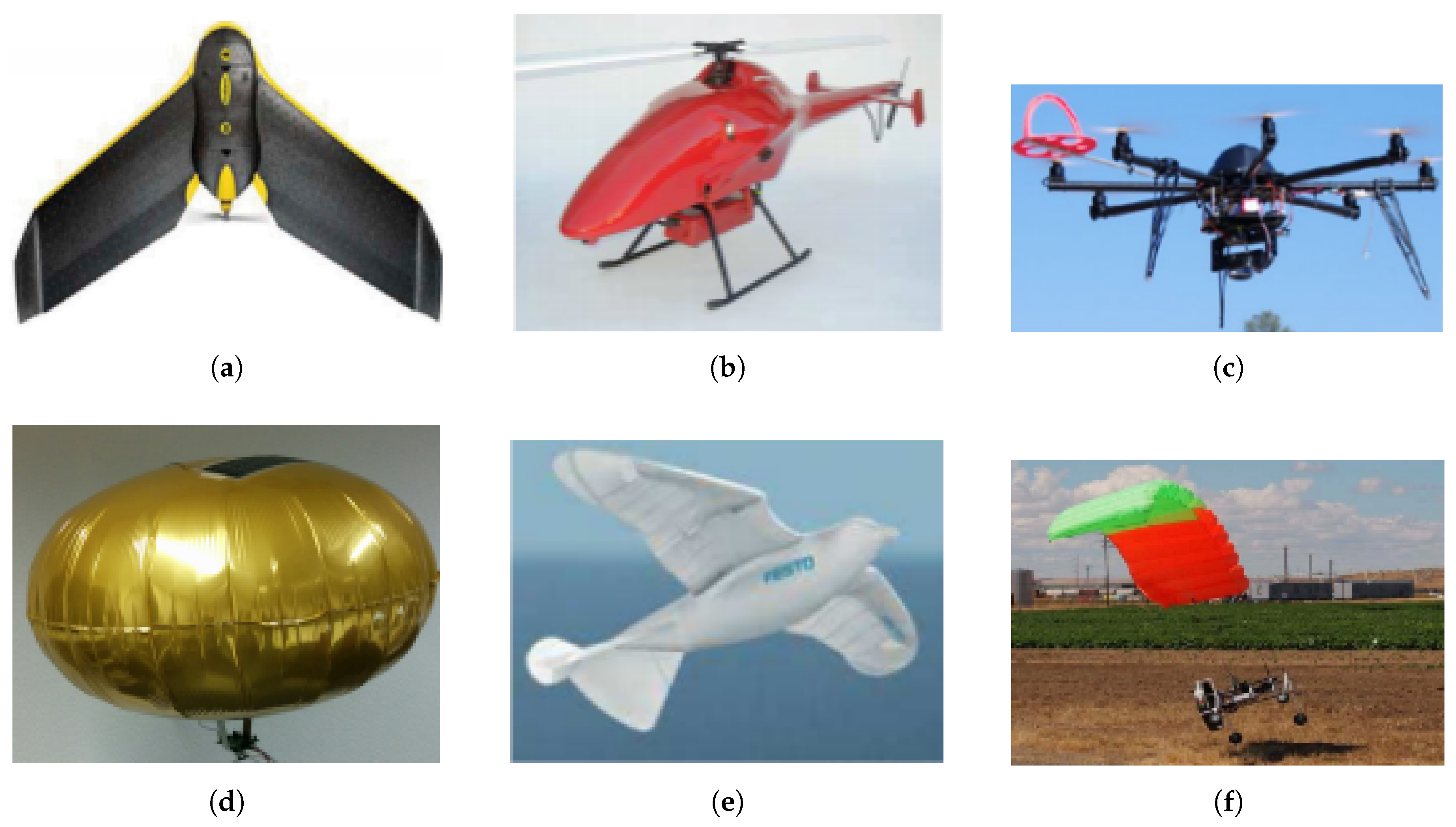
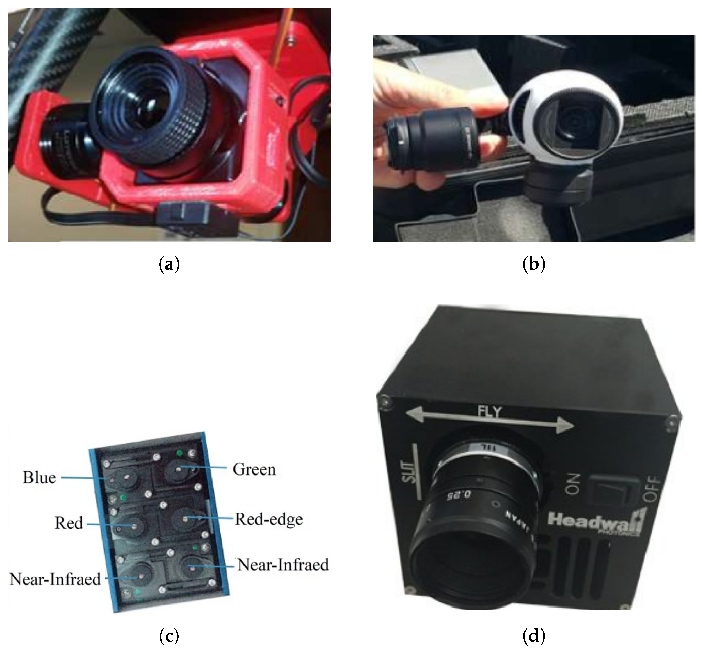
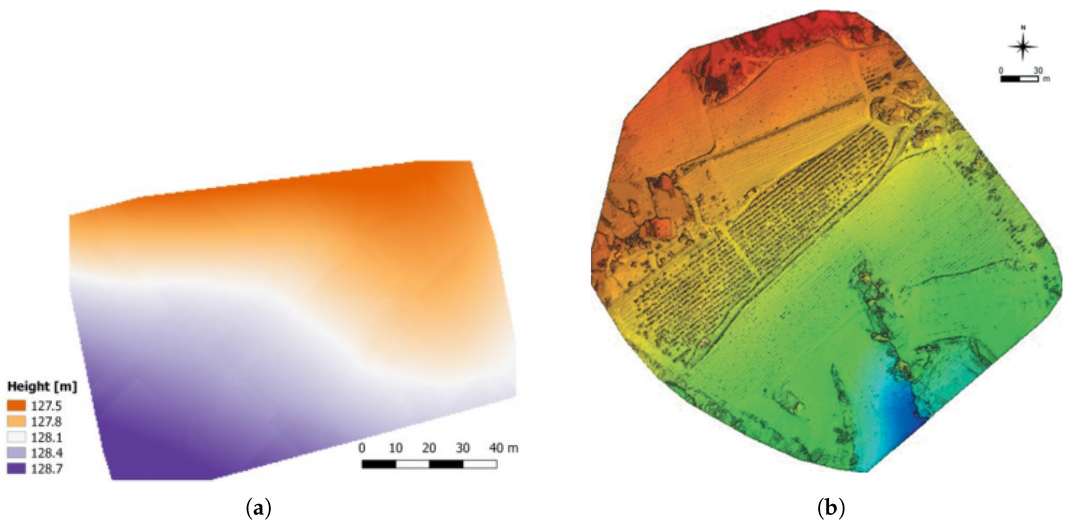
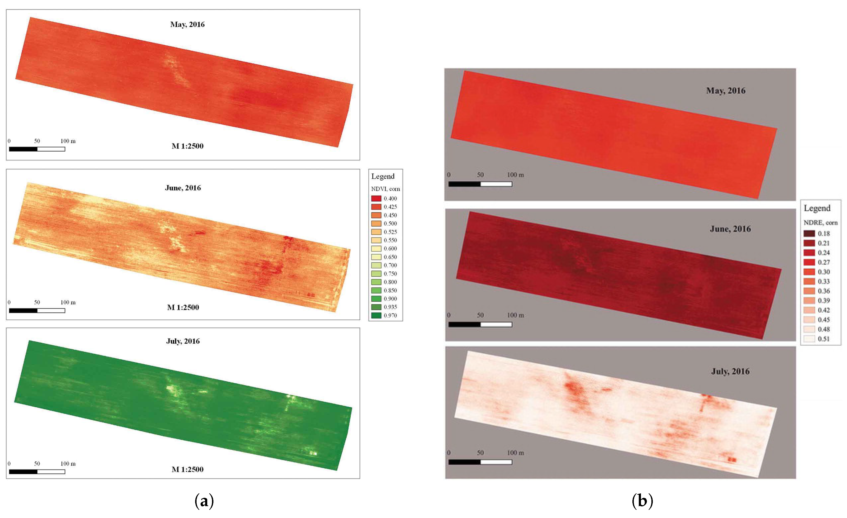
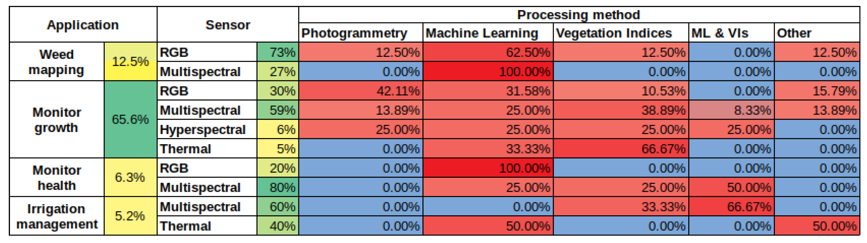
Table 1.
Crop features that can be monitored with UAVs.
| Crop Features | |
|---|---|
| Vegetation | biomass [22,103] |
| nitrogen status [22,99,103,110] | |
| moisture content [109,110] | |
| vegetation color [49,54] | |
| spectral behavior of chlorophyll [64,99] | |
| temperature [64,69] | |
| spatial position of an object [32,106] | |
| size and shape of different elements and plants | |
| vegetation indices [54,55,56] | |
| Soil | moisture content [109,112] |
| temperature [66,69] | |
| electrical conductivity [66] | |
Table 2.
Most common software tools used in the literature for image processing.
| Software Tool | Description |
|---|---|
| Adobe Photoshop [21,100] | Applied to correct distortion/use of other image processing methods |
| Agisoft Photoscan [22,36,37] | Exploited for the construction of 3D models and orthomosaics. It also allows the calculation of vegetation indices |
| QGIS [23,55] | Usually exploited for the calculation of the vegetation indices from multispectral data |
| MATLAB [35,100] | Applied mainly for the calculation of vegetation indices. It can also be exploited for other image processing methods |
| Pix4D [29,35,55] | The most commonly used tool. It can be used for calculating VIs and/or constructing of 3D models and orthomosaics |
Table 3.
Most used vegetation indices.
| Vegetation Index | Abbreviation | Formula |
|---|---|---|
| Vegetation Indices derived from multispectral information | ||
| Ratio Vegetation Index | RVI | |
| Normalized Difference Vegetation Index | NDVI | |
| Normalized Difference Red Edge Index | NDRE | |
| Green Normalized Difference Vegetation Index | GNDVI | |
| RGB-based Vegetation Indices | ||
| Excess Greenness Index | ExG | |
| Normalized Difference Index | NDI | |
© 2019 by the authors. Licensee MDPI, Basel, Switzerland. This article is an open access article distributed under the terms and conditions of the Creative Commons Attribution (CC BY) license (http://creativecommons.org/licenses/by/4.0/).
Share and Cite
MDPI and ACS Style
Tsouros, D.C.; Bibi, S.; Sarigiannidis, P.G. A Review on UAV-Based Applications for Precision Agriculture. Information 2019, 10, 349. https://0-doi-org.brum.beds.ac.uk/10.3390/info10110349
AMA Style
Tsouros DC, Bibi S, Sarigiannidis PG. A Review on UAV-Based Applications for Precision Agriculture. Information. 2019; 10(11):349. https://0-doi-org.brum.beds.ac.uk/10.3390/info10110349
Chicago/Turabian StyleTsouros, Dimosthenis C., Stamatia Bibi, and Panagiotis G. Sarigiannidis. 2019. "A Review on UAV-Based Applications for Precision Agriculture" Information 10, no. 11: 349. https://0-doi-org.brum.beds.ac.uk/10.3390/info10110349
Note that from the first issue of 2016, this journal uses article numbers instead of page numbers. See further details here.