
Virtual Geosites as Innovative Tools for Geoheritage Popularization: A Case Study from Eastern Iceland


1
Department of Human and Innovation Sciences, Insubria University, Via S. Abbondio 12, 22100 Como, Italy
2
Department of Earth and Environmental Sciences, University of Milan Bicocca, Piazza della Scienza 1, 20126 Milan, Italy
3
CRUST-Interuniversity Center for 3D Seismotectonics with Territorial Applications, 66100 Chieti Scalo, Italy
*
Author to whom correspondence should be addressed.
Geosciences 2021, 11(4), 149; https://0-doi-org.brum.beds.ac.uk/10.3390/geosciences11040149
Submission received: 26 February 2021
/
Revised: 21 March 2021
/
Accepted: 22 March 2021
/
Published: 26 March 2021
(This article belongs to the Special Issue Geological and Geomorphological Heritage – Protection versus Geotourism)
Abstract
:In this paper, we have adopted a modern, cutting-edge methodology to make geoheritage sites (geosites) available and explorable worldwide, through both immersive and non-immersive virtual reality, particularly suitable also in COVID-19 times. In doing this, we have focused our attention on five different outcroppings, shallow magma bodies in Iceland: such geological objects, although being often underestimated, are, on the contrary, very suitable for geoheritage popularization purposes. These outstanding outcrops have been transformed in virtual outcrops (VOs) through UAV-based photogrammetry 3D modelling, and have been uploaded on a brand-new, dedicated online resource (GeoVires Virtual Reality Lab for Earth Sciences) which is accessible worldwide for Earth Science teaching and communication. As already stressed above, the choice of these Icelandic shallow magma bodies has been suggested by the fact that such geological objects, although extraordinarily challenging both in terms of geotourism and teaching, are seldom the object of attention from the international scientific community. The five VOs are defined here as virtual geosites (VGs) because they are, indeed, geosites that are fully accessible with a smartphone, a tablet, or a PC; moreover, each is provided with a detailed description and notes available during 3D exploration. Our work could represent a model for future, similar efforts aimed at popularizing Earth Sciences and making geoheritage available to a broad public through VGs.
1. Introduction
The severe acute respiratory syndrome coronavirus-2 (SARS-CoV-2, the pathogen responsible for the COVID-19 pandemic) has been reported in each of the world’s countries. As of 26 January 2021, there were 98,925,221 confirmed cases and the death toll totaled 2,127,294 worldwide (https://www.who.int/publications/m/item/weekly, operational-update-on-COVID-19---26-january-2021 (accessed on 29 January 2021). To prevent the spread of COVID-19, most countries have implemented unprecedented restrictions, such as border shutdowns, domestic travel restrictions, limitations to public gatherings, and the closure of schools, shops, and restaurants. The lockdown of schools and universities across the world has particularly affected Earth Science teaching and communication, which usually entails field activity with the involvement of large student groups, field survey to foreign countries, and participation in face-to-face meetings, workshops, and congresses. In order to cope with these circumstances, sharing teaching and research materials online has become of paramount importance and also may be a key option when the present health crisis is over. A special role can be played by virtual reality techniques can be aimed at 3D visualization in geoinformation and geological sciences [1,2], where the virtual scenario (or landscape) can be based on open or ad hoc created geospatial datasets [3], including digital terrain/surface models and bathymetric data [4]. In the present work, we focused our attention on key parts of virtual landscapes, the so-called virtual outcrops (VOs), or 3D digital outcrop models (DOMs), which can be defined as 3D representations of surface geology [5,6] and are suitable for: (i) popularizing geoheritage for a general audience by explaining ongoing, active geological and environmental processes; and (ii) engaging the younger generation, usually particularly attracted to interactive forms of communication [7]. VOs may be regarded as being part of the geological heritage, better known as geoheritage, of a certain area. Geoheritage, illustrated and reviewed in a series of papers over the last two decades [8,9,10,11,12,13,14], involves elements of geological and geomorphological diversity having cultural, educational, scientific value, which can be popularized through institutions such as geoscience museums [15,16,17] and geoparks [18,19,20], as well as, of course, geotourism, also related to the so-called “geomorphosites” [21,22,23,24,25]. VOs may also be considered the virtual counterpart of “geosites”, the most thorough classification of which was reported in a key paper [26], in which the following categories of geosites were identified: geological, structural, tectonic, geomorphological, mineralogical, petrographic, sedimentological, stratigraphic, paleontological and others. Regarding volcanic geoheritage and geosites, a number of recent papers have described them thoroughly [27,28,29,30,31,32,33,34,35,36]. It is worth noting that complex geosites also exist, which represent a combination of two or more of the categories listed above. Geosites may be represented by outcrops, quarries, caves, mines, volcanic landforms and products, subvolcanic structures as well as tectonic structures [36]. Their relevance can be global, national, regional, or local [37], and they may also be further classified [38] regarding their appearance (spatially limited sites such as outcrops, linear features such as dykes and faults, aerially extended features such as mountain peaks) and dynamic state (inactive processes as opposed to active ones). When it comes to geosites, it is worth attempting to qualitatively assess their quality (whenever possible, also quantitatively). A number of studies have tried to make such assessment efforts, in terms of the scientific value [39] of geosites, which is composed of four sub-criteria, namely, representativeness, rarity, integrity [11,27,40] as well as the current scientific knowledge about the geosite, reflected by the number of published scientific studies [7]. Representativeness reflects how a geosite is representative of the geological process that formed it. On the other hand, the rarity of a geosite reflects its uncommonness at the regional or global level [40]. Moreover, there are other values, defined as “additional” [41,42], which can be identified and assessed, namely, the cultural, aesthetic, economic and educational aspects. All are very important in terms of geoheritage and geotourism, but the educational value is especially important with regard to geosites, which can be considered particularly suitable for explaining geological processes, both active and non-active, to the general public. The virtual outcrops featured in the present work, which can be regarded as “virtual geosites”, are all related to specific processes taking place in the shallow Earth’s crust, which give rise to particular geological features known as “subvolcanic bodies”. These have been described in a series of general papers [43,44,45], and others, specifically dedicated to Iceland [46,47,48] and elsewhere [49,50]. Our focus on subvolcanic bodies is justified by the fact that they are generally poorly known outside the limited number of specialists that deal with these spectacular magmatic features. Therefore, we wish to popularize them as valuable geosites, possibly worthy of geotouristic interest. In the present paper, we showcase a few virtual geosites from eastern Iceland, and show a methodology to make them available to the general public thanks to cutting-edge methodologies comprising the use of drones and Structure for Motion (SfM) techniques. Moreover, we attempt a brief and qualitative assessment of the geosites, according to the methods applied by a number of seminal papers focused on the topic of geosite evaluation.
2. Geological Background
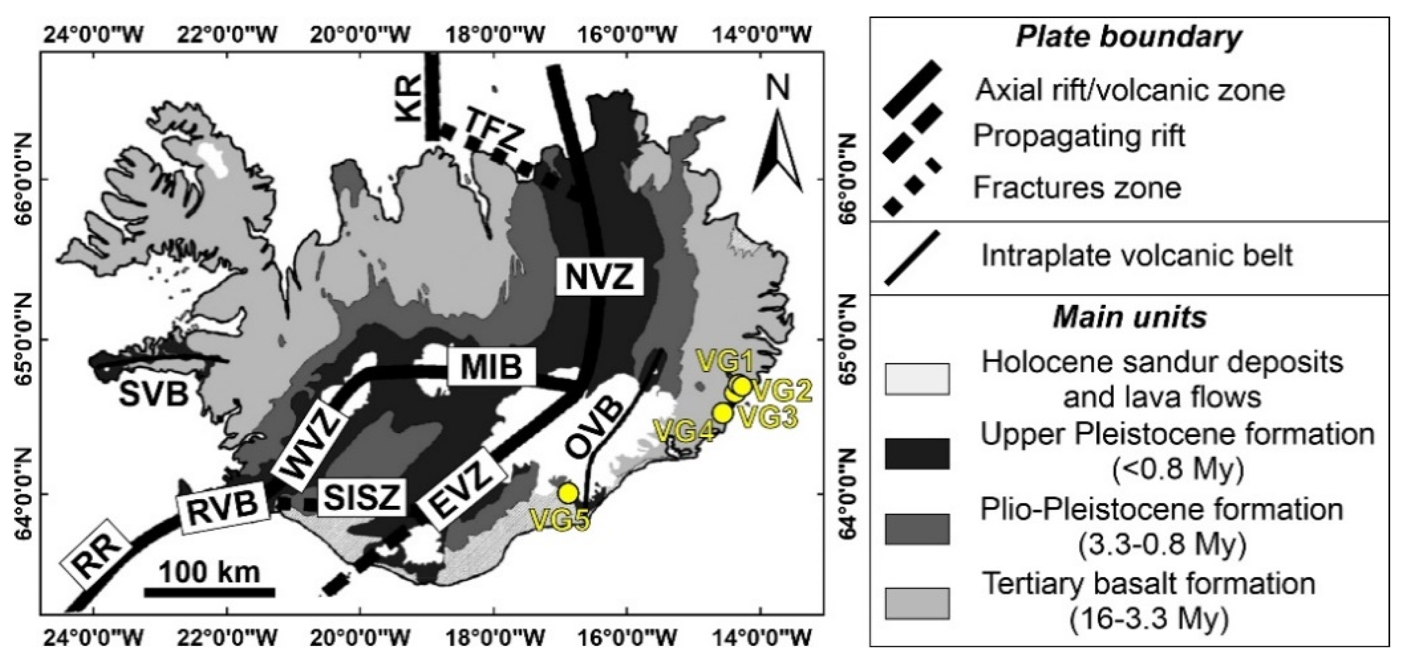
The arrangement and distribution of volcanic activity in Iceland results from the combination of magmatism derived from the Iceland mantle plume and plate separation processes. The main results of this interaction are so-called neovolcanic zones, 15–50 km wide areas of volcanism and active faulting [51,52,53,54,55,56]. These zones cover about one-third of Iceland and are composed of volcanic systems, which are the main structures characterizing such volcanic zones (Figure 1). There are 30 of such active systems in Iceland, composed of a fissure swarm or a central volcano, or both [56].
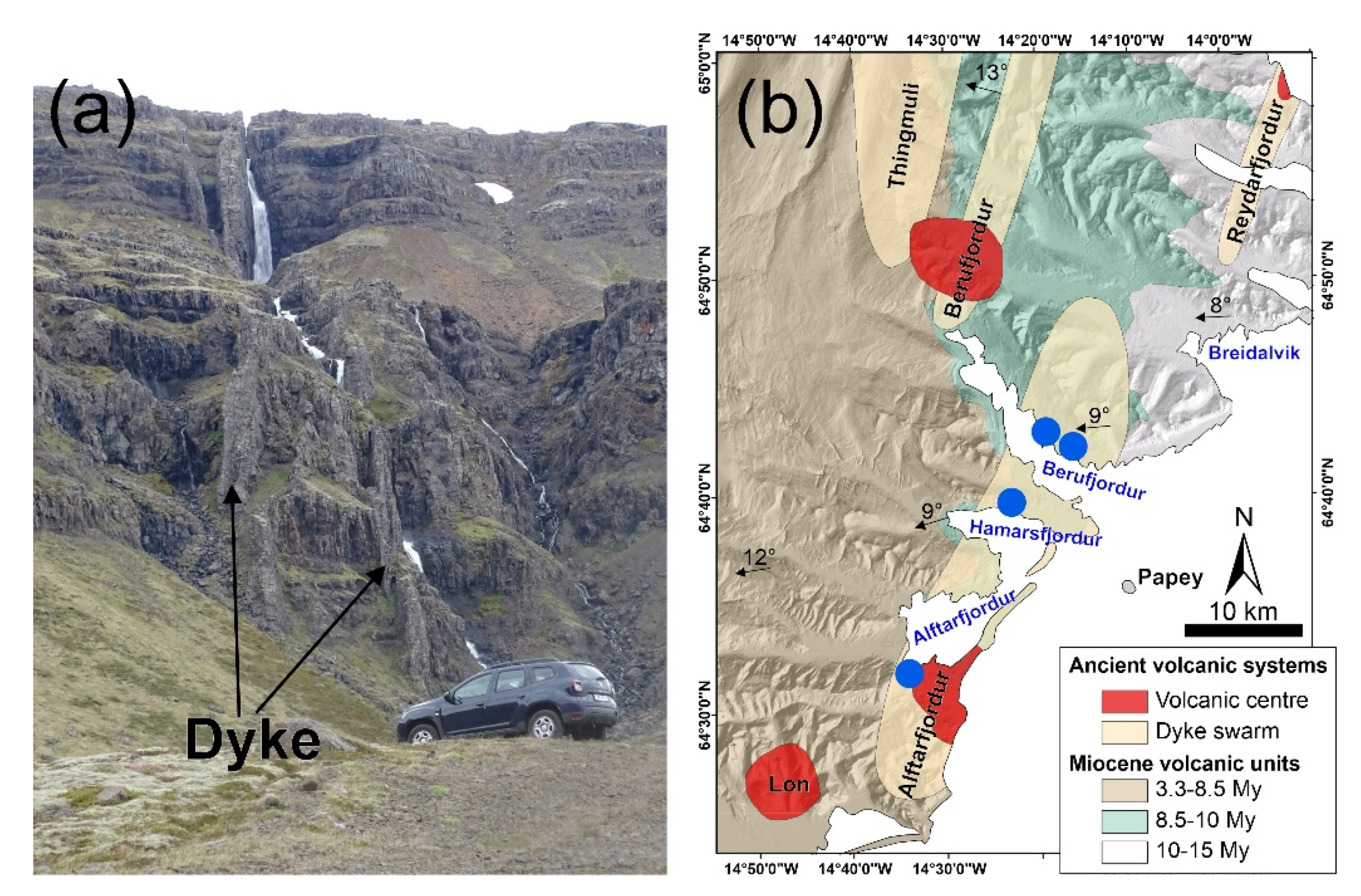
Apart from active, neovolcanic zones, there are plenty of extinct volcanic areas in Iceland, the most spectacular of which are the inactive systems that can be observed along the western and eastern coasts. For instance, along the eastern coastline, a series of thick lava successions of Miocene age are cut by dyke swarms (e.g., Figure 2a [58]). A series of papers [59,60,61,62,63] have focused on the dyke swarms of eastern Iceland. In this area, the lava flow succession is tilted towards the WSW, with several angular unconformities.
According to Bourgeois et al. [64], the observed tilt is the result of a major roll-over produced by an eastward-dipping, normal listric fault located to the west. The study area is mainly characterized by basaltic lava flows with alternating intermediate to felsic lavas, cropping out near the volcanic centers. The deeper sections of the volcanic centers are mainly made of mafic (but also felsic) subvolcanic rocks which were emplaced in various shapes and sizes: they include sills, dykes, cone-sheets, and laccoliths [60,65]. Previous authors have interpreted the mafic and felsic, subvolcanic intrusions as magma reservoirs, which became feeders for surface eruptions and from which other sheet-like intrusions were ejected. The exhumation of the subvolcanic features in the area, which has made it possible to observe and study them, was produced from both recent uplift and erosion from glaciers. The depth of erosion in southeast Iceland can be as much as 2 km [65,66]. The study area is characterized by evidence of glacial erosion, especially in the form of fjords formed by glacial tongues during the last Ice Age. In Iceland, there are a great deal of these stunning geomorphological features, both in the west of the country, and in the east, such as in the study area. With regard to climate, the Icelandic climate is of the maritime type, with precipitation rates of more than 7000 mm per year in the south and east, which decrease towards the north-west of the country [67]. In our study area, we could observe only sparse evidence of “pingos”, which are widespread in the north of Iceland, such as in the North Volcanic Zone: they are periglacial morphologies covering the underlying basaltic lava flows, formed owing to the growth of ice lenses within the soil. Further details on the geology of eastern Iceland can be found in Walker [68], Gudmundsson [69], Jóhannesson and Sæmundsson [70] and Gudmundsson [44]. The sites we present are located in ancient volcanic system (Figure 1 and Figure 2b)
3. Virtual Outcrops Building
In order to accomplish the goals of the present work, we have extensively used the Structure from Motion photogrammetry technique for constructing 3D models in volcanic areas [71,72,73]. The SfM photogrammetry technique is widely used in Earth and Environmental Sciences, because it provides high-resolution photo-realistic 3D models as final products, by estimating three-dimensional structures from two-dimensional image sequences [74,75]. The overall workflow we have used can be subdivided into two main steps: (i) drone-based image collection; and (ii) photogrammetry processing and 3D model building.
3.1. Drone-Based Image Collection
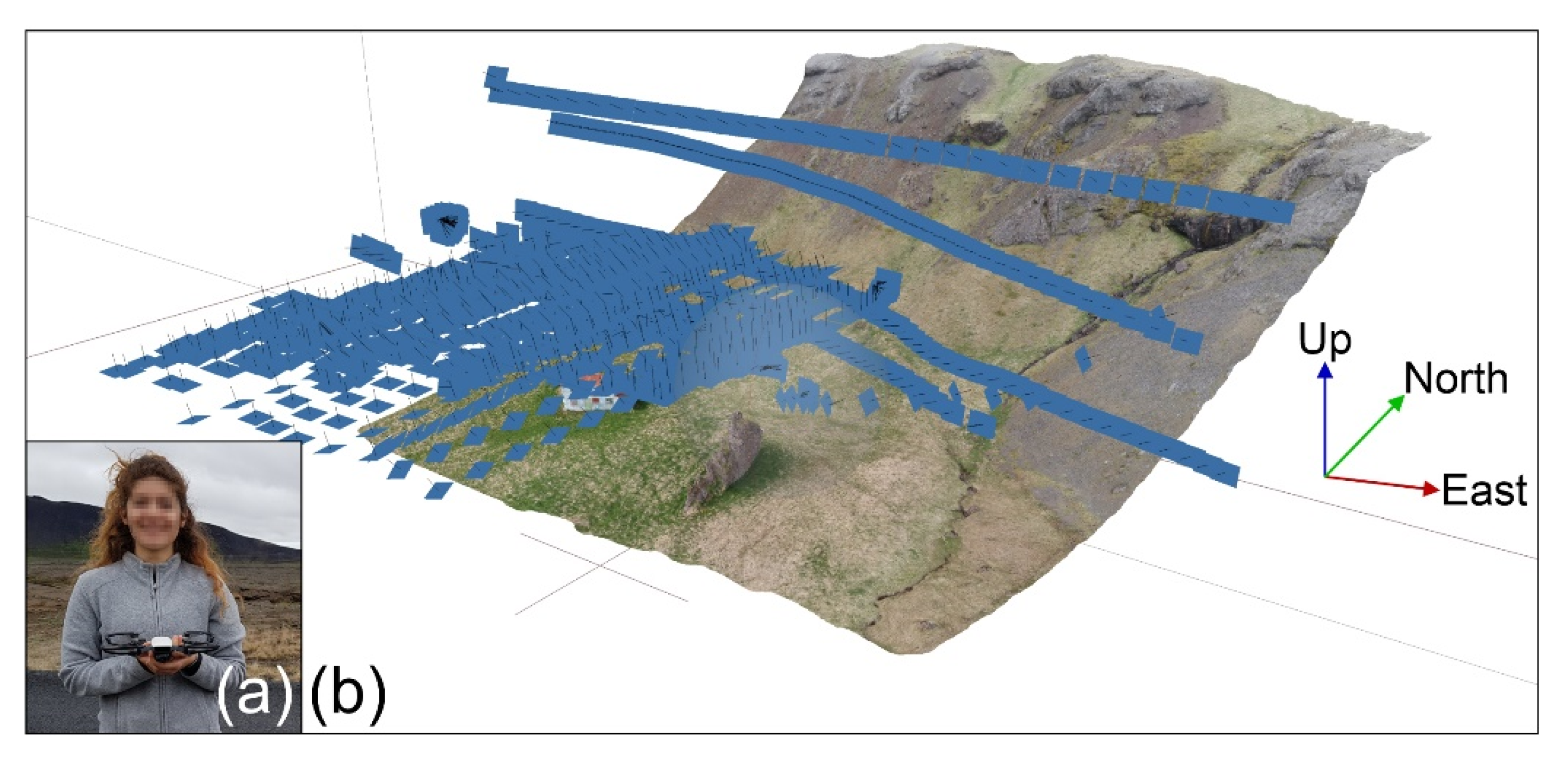
The first step is devoted to collecting pictures, a task that, regarding our models, has been accomplished by means of unmanned aerial vehicles (UAVs). We chose the multi-rotor vehicle DJI Spark (www.dji.com, accessed on 12 February 2021), a 0.300 kg vehicle (Figure 3a) equipped with a 1/2.3 inch CMOS sensor capable of capturing 12 megapixel pictures, including EXIF information (Exchangeable Image file Format) and GPS geographic coordinates (DATUM WGS84); its flight time is approximately 16 min and it can be remotely controlled. It is characterized by very stable hovering, can be easily carried in the field, and can fly at a very low height, thus enabling greater field resolution, and proving very useful for VO reconstruction [76].
Generally speaking, pictures collected using drones, or cameras, need to have a high overlap ratio, usually greater than 75–80% with the next pictures, and must be orthogonally oriented to the target [77]. For the goals of the present work, pictures were collected with the camera always orthogonal to the selected targets, the ground, and the vertical cliffs, with the camera in nadir and oblique orientations, respectively [73,77]. Drones were always flown manually at low speed (2–3 m/s) mostly at a flight heigh of 25 m above the ground, and at about a 15 m distance from vertical targets (e.g., Figure 3b), capturing images every 2 s (equal time interval mode), always in optical light condition. The limited velocity has been helpful in minimizing motion blur, avoiding the rolling shutter effect, and achieving well-balanced camera settings (exposure time, ISO, aperture), thus ensuring the collection of sharp and correctly exposed images [78]. Moreover, to reduce shadows around elevated features, drones were flown with the sun straight overhead (zenith). The overlap ratio obtained by means of the above methodology was always greater than 90%.
3.2. Photogrammetry Processing for VOs Building
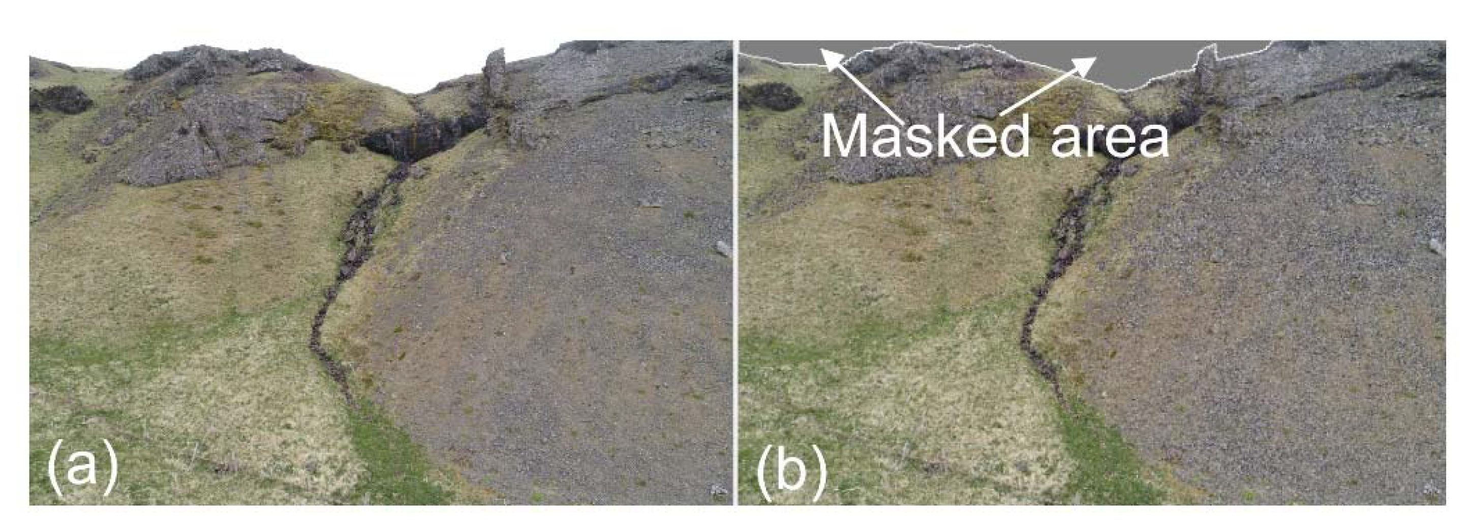
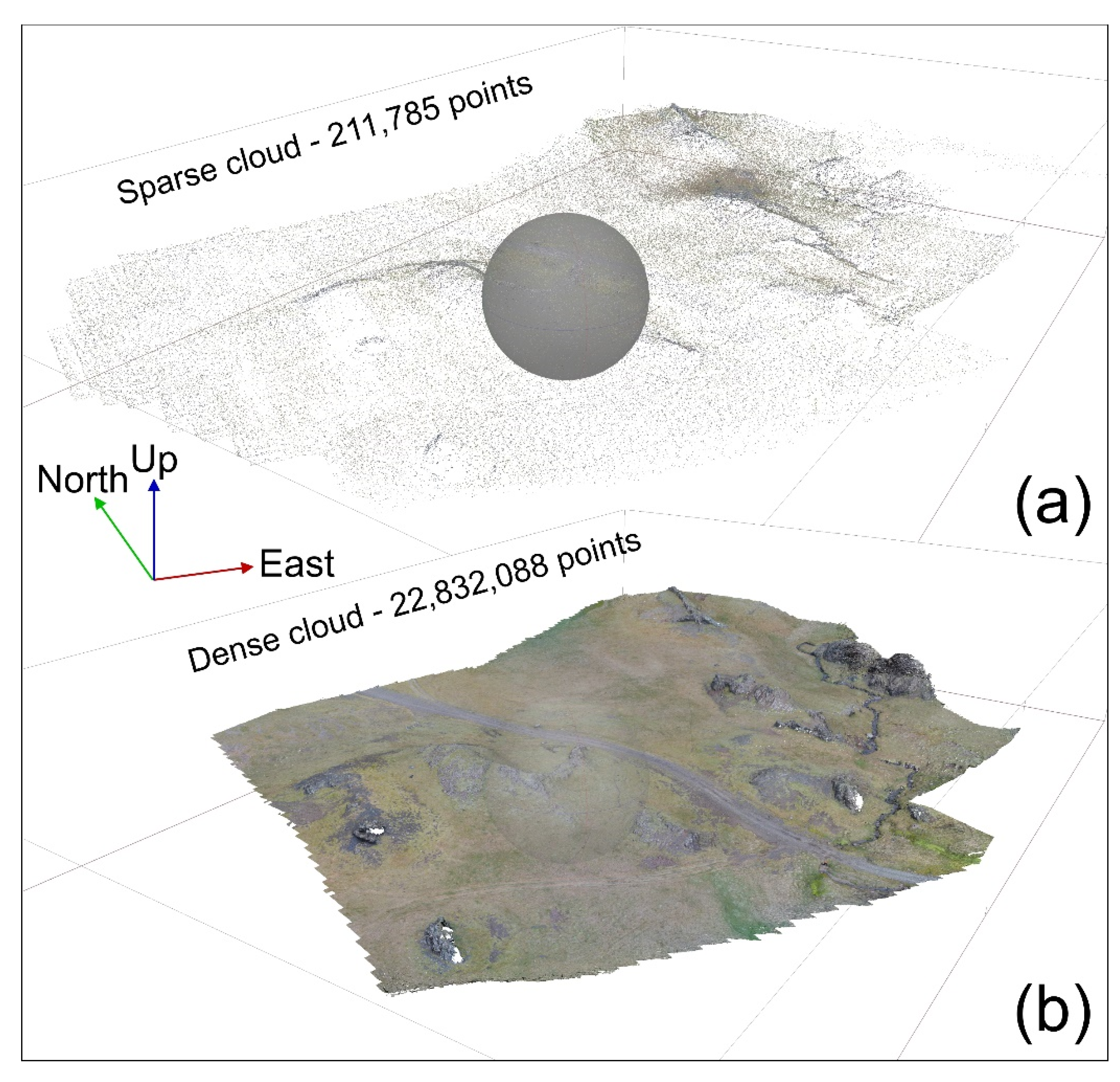
The collected images have been processed through Agisoft Metashape (http://www.agisoft.com/, (accessed on 20 January 2021), which is commercial Structure from Motion software. This application has been increasingly used for both UAV and field-based SfM reconstructions, owing to its user-friendly interface, intuitive workflow, and high quality of point clouds [79]. Here, we illustrate the steps we followed to produce our VOs. The first step was to import and prepare the pictures, to make sure that all the areas external to the target were masked (e.g., sky and clouds) (Figure 4a,b), to run a better alignment and to obtain a greater sparse and dense cloud [73]. Subsequently, we ran an initial low-quality picture alignment considering both Generic and Reference preselection settings; thereafter, by visual inspection, we excluded photos with quality value ˂0.8 or out of focus. Afterwards, the remaining pictures were aligned with high quality settings (both Generic and Reference preselection), obtaining the sparse cloud (Figure 5a). The following phase consisted of reconstructing the dense point cloud (Figure 5b) from the sparse point cloud, using a mild depth filtering and medium quality settings. On the resulting dense cloud, the “Filter by confidence” tool was firstly applied to remove incorrect points, selecting those with a value equal to 1. Then, possibly persisting incorrect points were removed by visual inspection. Finally, even though this is not an essential task for visualization purposes, it was possible to reference and scale the resulting dense cloud [75,80,81]. It is suggested to add at least four artificial referenced markers near every corner of the area; an additional one has to be fixed in the central part, with the purpose of reducing any “doming” effects resulting from SfM processing.
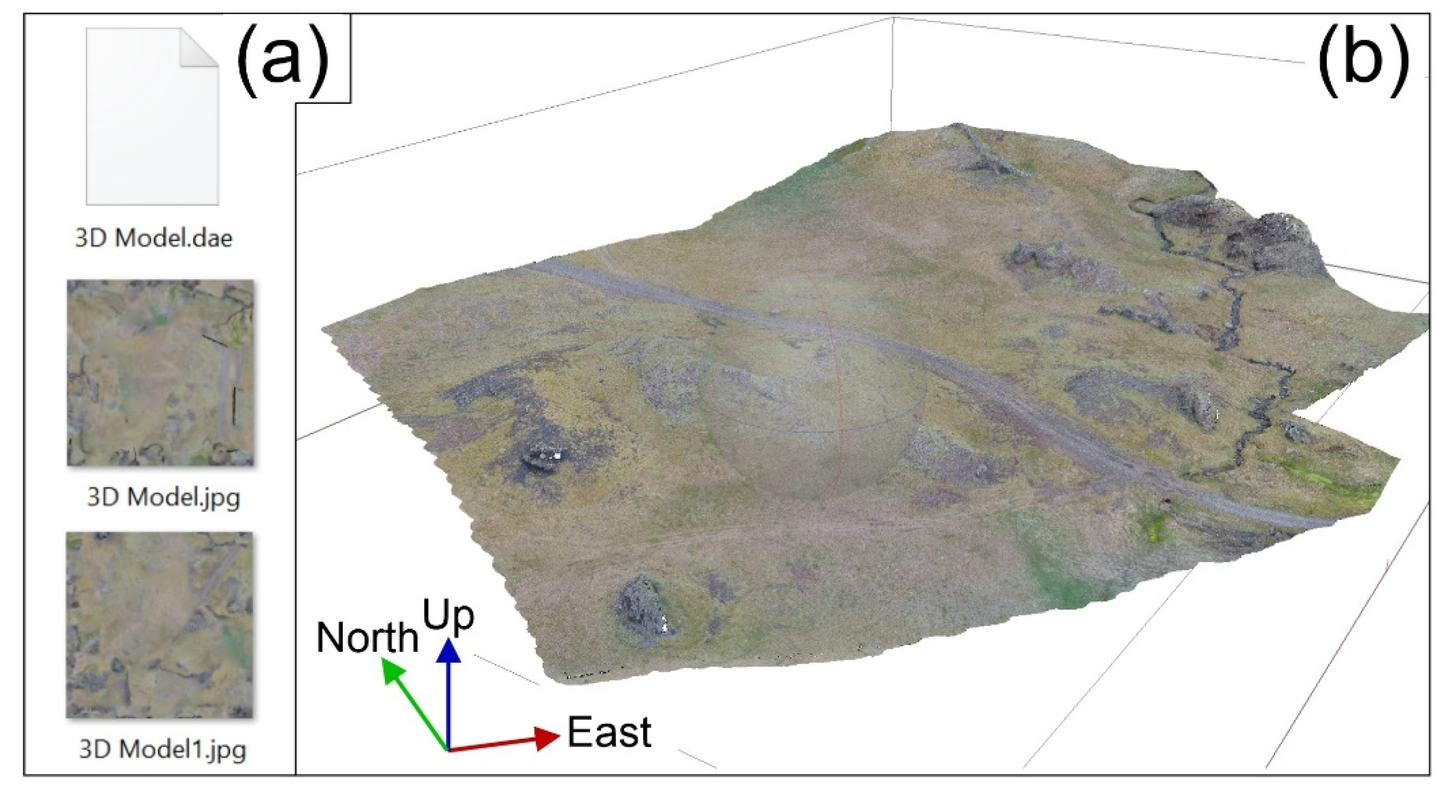
Finally, we created the VOs from the dense cloud, in the form of 3D models with the following settings: 2,100,000 faces for the mesh, and two separated files for the texture; then, we exported the 3D model in Collada file format [82]. The output was composed of three files (Figure 6a); one for the mesh (DAE file extension), and two for the texture (JPG file extension) (Figure 6b). Such settings allow for the uploading of the 3D model on Sketchfab (www.sketchfab.com, accessed on 13 February 2021) within the 200 MB size limit imposed by the educational license, still providing an excellent quality, as shown in Figure 6b. The texture resolution in our models was always of 1 cm/pixel.
4. Strategy for Worldwide Sharing of the VOs
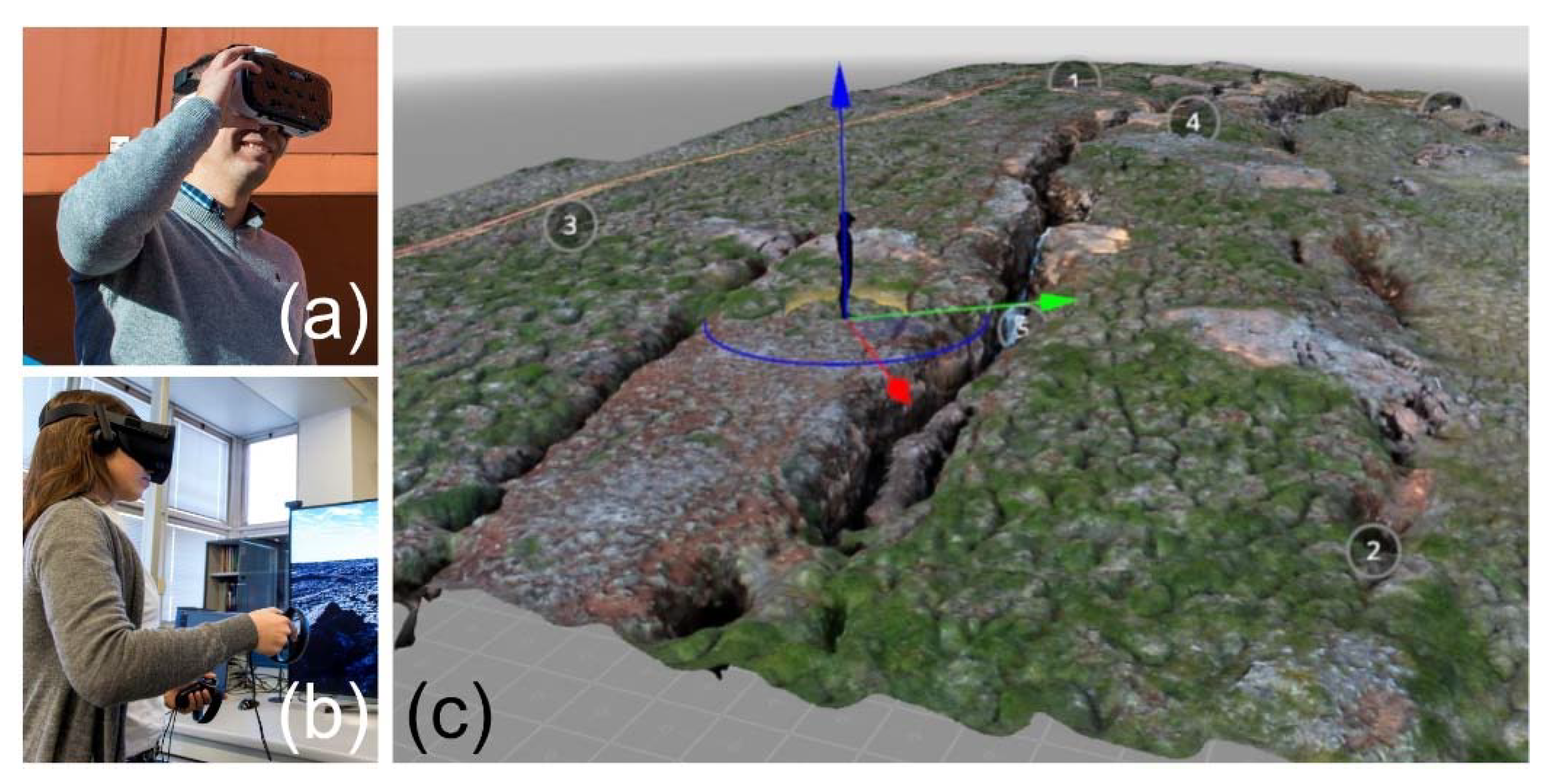
Each VO has been shared online and is accessible worldwide through the internet; moreover, each is provided with a dedicated webpage, a full text explanation, and an interactive 3D visualization on https://geovires.unimib.it/shallow-magma-bodies/ (accessed on 11 February 2021). In each dedicated web page, we added the hyperlink to the model, uploaded on the Sketchfab platform—educational license, which enables visualization through immersive virtual reality (VR) [1,2,83] as well as 3D visualization on a computer workstation [5], tablet or a smartphone—defined as non-immersive VR; augmented reality (AR) contents can be added as scientific annotations [84]. Following the definition from Choi et al. [85], the material we uploaded can be used for a non-immersive VR experience by displaying the model on a PC screen or a mobile device without any head-mounted displays; alternatively, it can be used for a fully immersive VR experience, enabling greater interactivity, by way of head-mounted displays such as VR headsets and goggles (e.g., Figure 7a,b). In order to allow for the 3D visualization, each VO has been uploaded on the Sketchfab platform through a straightforward drag-and-drop procedure; the platform automatically builds up the 3D scene, which is almost ready for non-immersive visualization; and a series of settings can be adjusted, regarding the initial view, the model orientation, the field of view, light/shadow settings, etc. Furthermore, using the Sketchfab platform, each model can be explored using the embedded immersive virtual reality (VR) tool; VR contents were made available for several devices: Google Cardboard and more generic VR goggles for mobile phones (Figure 8a), HTC Vive, Oculus Rift (Figure 8b) and others (further details at https://sketchfab.com/virtual-reality) (accessed on 9 February 2021). For the best immersive VR experience, the viewer’s starting point and the height need to be set up, as well as the direction of observation (e.g., Figure 8c). The user can observe the model using the immersive VR and move across the scene by selecting the annotations to explore the most relevant features in each model, annotation by annotation. Finally, considering the importance of such sites, their worldwide accessibility and the information provided for each site, we hereby define them as virtual geosites (VGs).
5. Description of the Selected VGs and Related “Scientific Virtual Geotours”
In the following section, we describe each of the VGs, the locations of which are shown in Figure 1 and Figure 2b, from north to south, highlighting the most relevant features to be explored in each model, in a sort of “scientific virtual geotour”.
Before describing the VGs, we highlight the main characteristics of the subvolcanic bodies illustrated in this work: dykes, inclined sheets, sills, and laccoliths, which occur in Iceland and according to the definitions provided by Gudmundsson et al. [45]. Dykes in Iceland are observed almost always in elongated, parallel swarms outside central volcanoes. They have a roughly vertical attitude, and their strike is the same as that of all the other dykes within a swarm. Their strike, in the southern half of Iceland, is generally north-east, whereas in the northern part of the country they generally trend north-north-east. Their thickness varies from a few cm to about 60 m, although most commonly it ranges between 1 and 2 m. Regarding inclined sheets, these are subvolcanic bodies that are always related to central volcanoes (stratovolcanoes, calderas). Most sheets are injected in the surrounding host rocks from shallow magma chambers and occur in swarms of up to hundreds and thousands; such swarms are circular to slightly elliptical in plan view and, in Iceland, have a maximum diameter of about 18 km. Their average thickness in Iceland is <1 m, and their dip is between 30° and 60°. Sills are very common in Iceland’s Tertiary lava successions, as well as in the Upper Pleistocene Formation and recent, active volcanic systems. Their attitude is horizontal to sub-horizontal; many of them are formed from the deflection of vertical dykes (or inclined sheets) propagating towards the surface through the host rock; these abruptly change their attitude, turning it horizontal, as they encounter discontinuities such as contacts between smoother hyaloclastite layers and stiffer lava flows. The thickness of sills in Iceland is between a few centimeters to 120 m. Some extend for several kilometers laterally. Finally, laccoliths are complex, sub-volcanic intrusions that are rather common all across Iceland, both felsic and mafic. The idea for their formation is that they were intruded at shallow depths as a combination of sills stacked atop each other. It is most likely that laccoliths, especially those with thicknesses of several hundred meters, acted as short-lived magma chambers. Moreover, we would like to clarify that, in Iceland and also in Scotland, for example, there are other areas where dykes, sheets, sills, and laccoliths can be observed. In Iceland, especially interesting are the subvolcanic bodies in the Esja Peninsula [46] and in the Snaefellsnes Peninsula [48]. In Scotland, the Isle of Skye is a major example of the coexistence of such volcanic bodies in a stunning subvolcanic environment [50]. However, the above locations are too remote to be experienced by potential geotourists.
5.1. VG1: A Laccolith Intruded within a Basaltic Lava Flow Succession
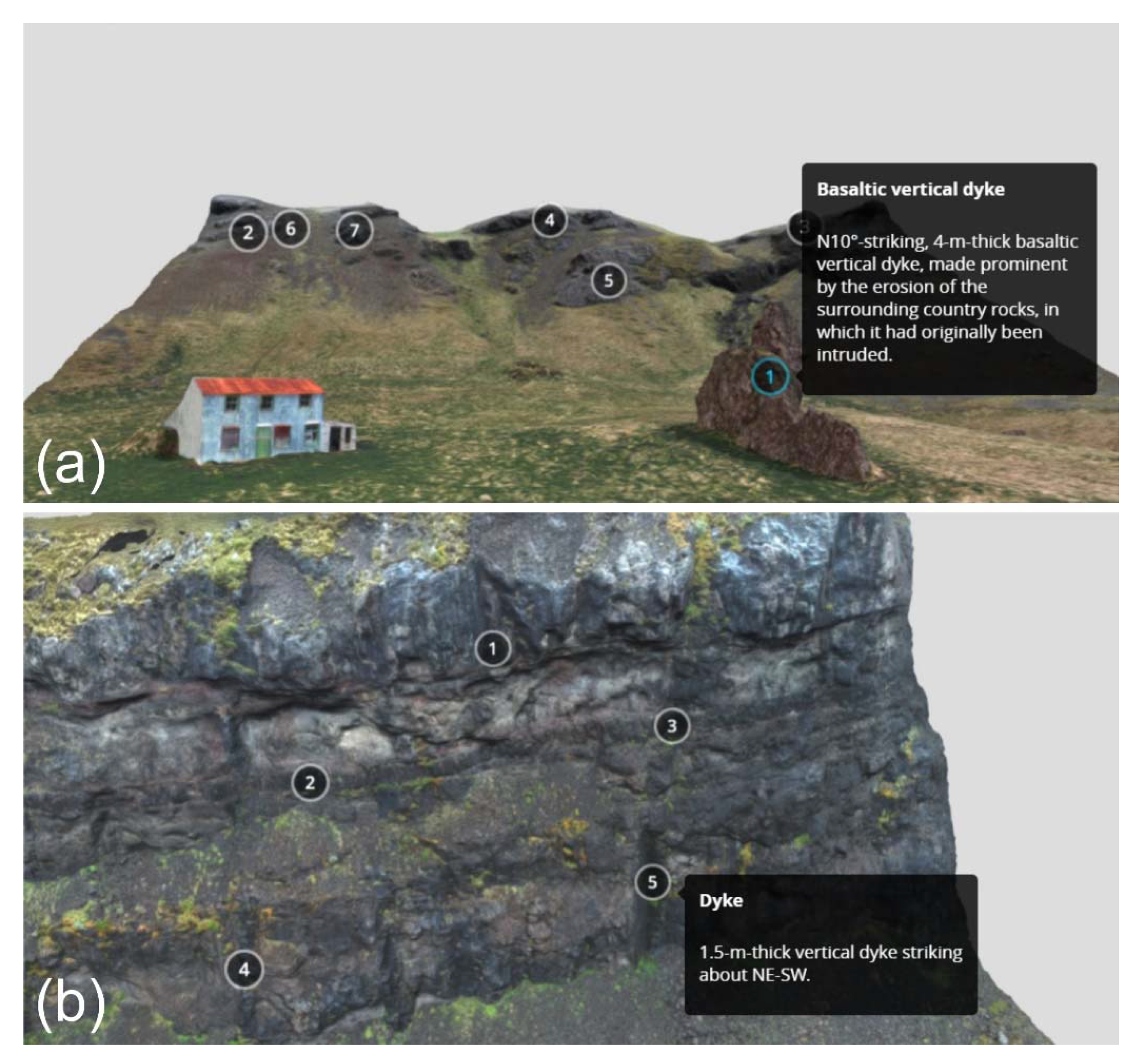
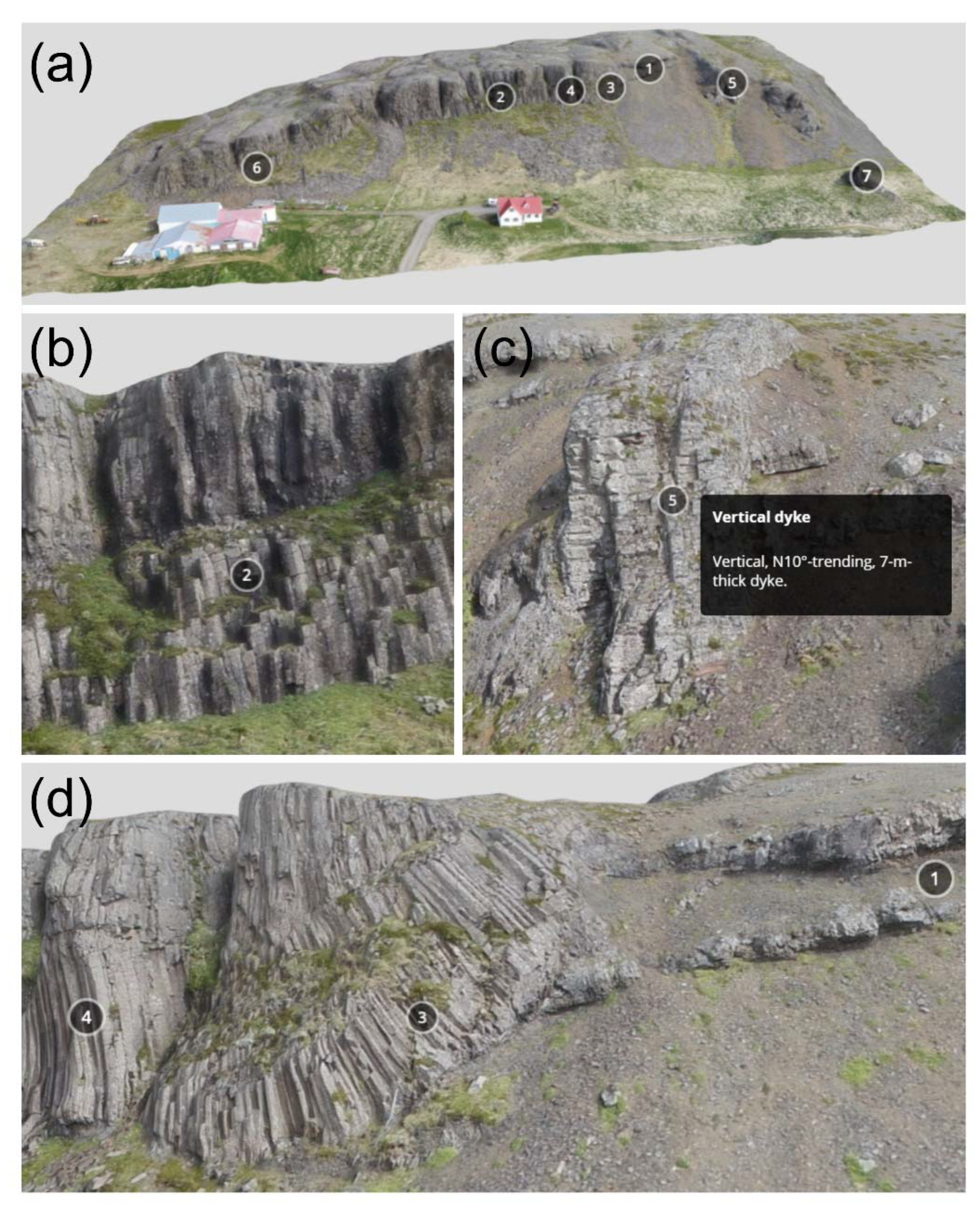
Virtual Geosite 1 (VG1) is available at https://geovires.unimib.it/shallow-magma-bodies/smb_002/ (accessed on 12 February 2021), and shows a 250 m × 120 m wide area located in eastern Iceland, within Tertiary age units. To the right-hand side of the model (Figure 9, annotation 1), a horizontal lava succession crops out. Moving to the left, we can observe a textbook example of an 18 m-thick, doleritic laccolith (e.g., Pasquarè and Tibaldi [86]; Tibaldi et al. [46]) which was emplaced within the lava succession, and which is characterized by thick columnar joints that form during cooling of the subvolcanic intrusion (annotation 2). Most of the columns are vertical, but on the right-hand side of the model, they bend and attain a gentler dip. This very peculiar process, which can hardly ever be observed with such clarity in the field; it has been observed and thoroughly documented in western Iceland by Pasquaré and Tibaldi [86], and Tibaldi and Pasquaré [47]). On the right-hand side (SE) of the area, the lava succession is intruded by a vertical, N 10°-trending, 7 m-thick dyke (annotation 5), and to the extreme right-hand side of the model the remnant of another, thinner dyke (annotation 7), is standing isolated in the foreground. This model is very helpful for the viewer to understand processes related to laccoliths, the emplacement of which occurs in preferentially horizontal direction within the host rocks (in Iceland, they are most often lavas or hyaloclasistes); as opposed to this, the two subvolcanic bodies on the right-hand side of the model are emplaced with a steep inclination, a mechanism of intrusion that is typical of dykes, the most common subvolcanic bodies in Iceland.
5.2. VG2: Inclined Sheet Emplaced along a Normal Fault
Virtual Geosite 2 (VG2) is available at https://geovires.unimib.it/shallow-magma-bodies/smb_004/ (accessed on 13 February 2021), and encompasses an area of about 250 m × 380 m; the 160 m-high cliff is made of a succession of Tertiary basaltic lava flows gently dipping to the left (west). The virtual geotour starts from Figure 10, annotation 1, showing the gently dipping succession of lava beds. The succession is crosscut (annotation 2) by a 6.5 m-thick inclined sheet dipping about 55° to the right (east). Looking with attention at the geometry of the lava succession on either side of the inclined sheet, it is possible to notice that each single lava bed is vertically offset by about 5 m, with a downthrow of the hanging-wall block. This evidence suggests that the inclined sheet was emplaced along a normal fault. The dip and kinematics of the fault is coherent with the tilting of the lava succession to the left (annotation 3).
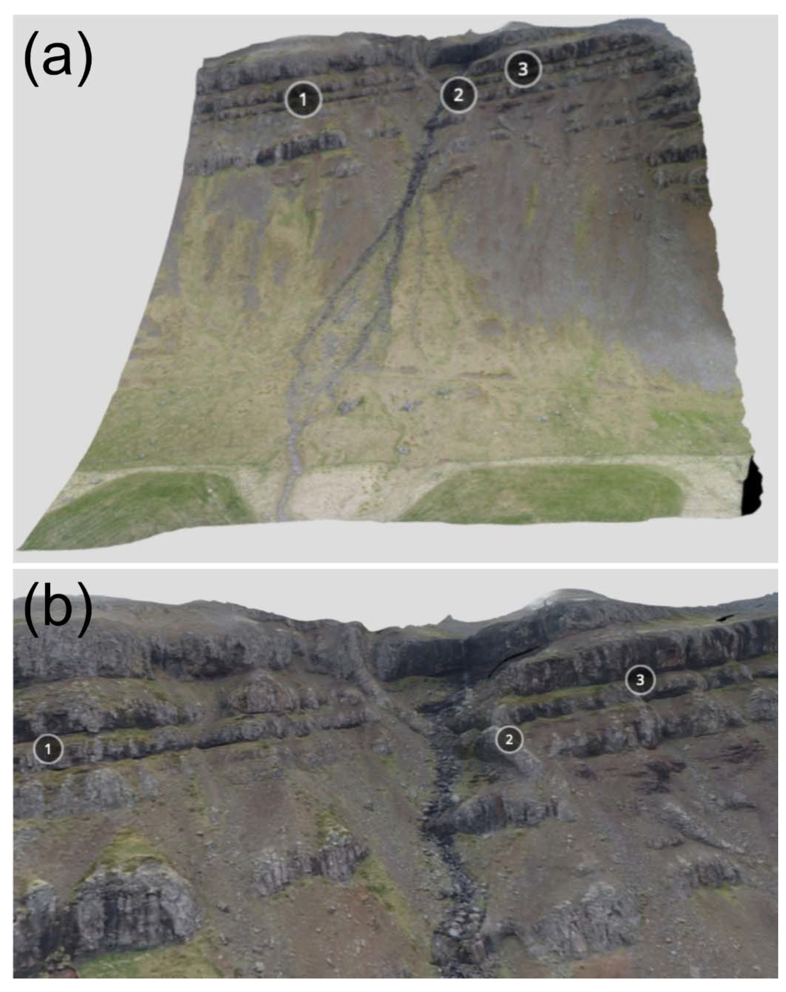
5.3. VG3: Outstanding Vertical Dykes and Inclined Sheets
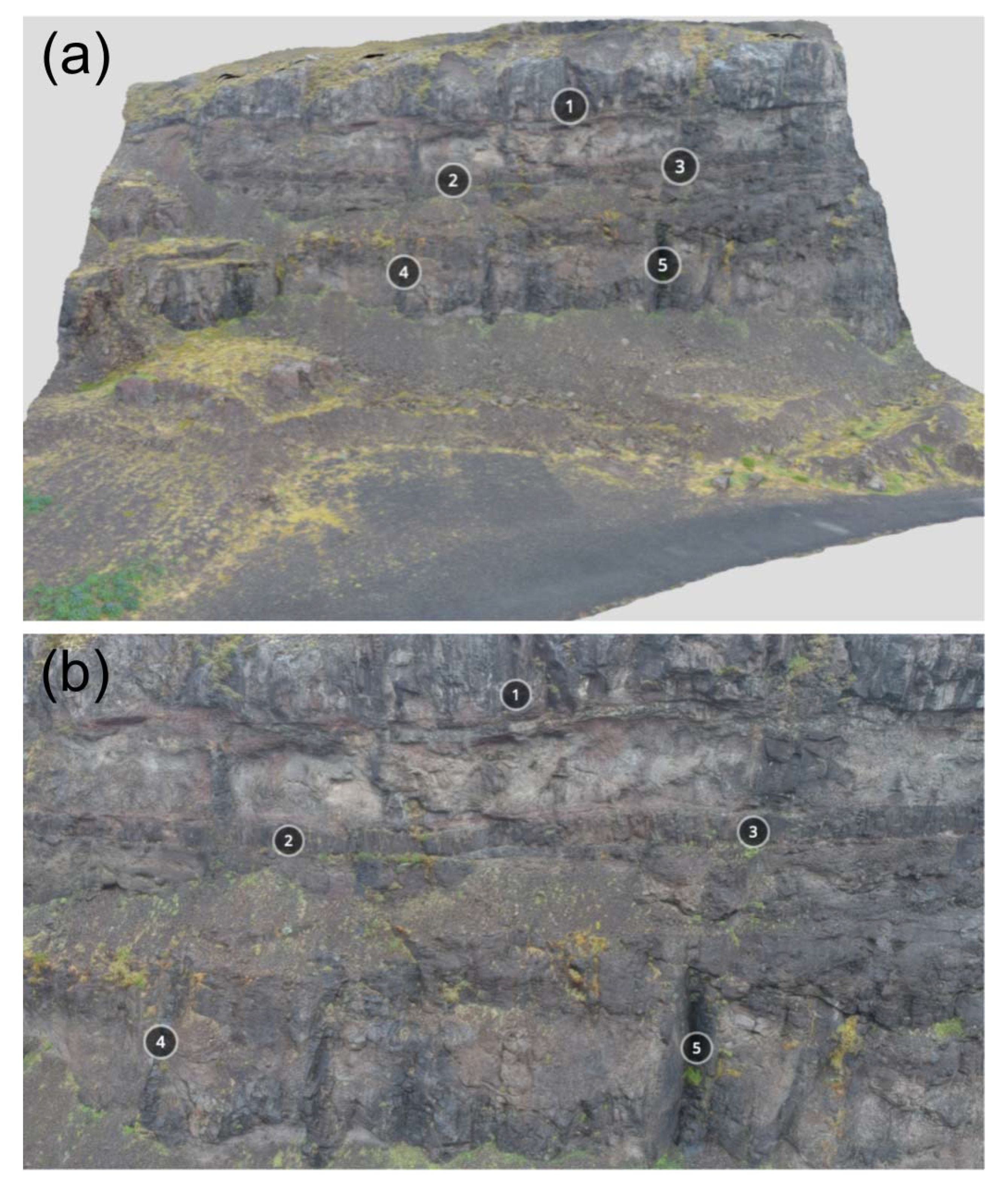
Virtual Geosite 3 (VG3) is available at https://geovires.unimib.it/shallow-magma-bodies/smb_001/ (accessed on 12 February 2021), and covers an aerial extent of 135 m × 115 m. The area is located in eastern Iceland, within Tertiary age units. The virtual geotour starts with Figure 11, annotation 1, describing a towering, N 10°-striking, 4 m-thick basaltic vertical dyke in the foreground, made prominent by the erosion of the surrounding country rocks, in which it had originally been intruded. In the background, a cliff can be noticed, made of a succession of basaltic lavas (annotation 2) dipping at a shallow angle to the west (left). Annotations 3, 5, 6 and 7 point to a number of vertical dykes cutting through the lava succession. Annotation 4 highlights an inclined sheet cutting through the lava succession, with a different attitude from the surrounding dykes.
5.4. VG4: Dykes and Inclined Sheets
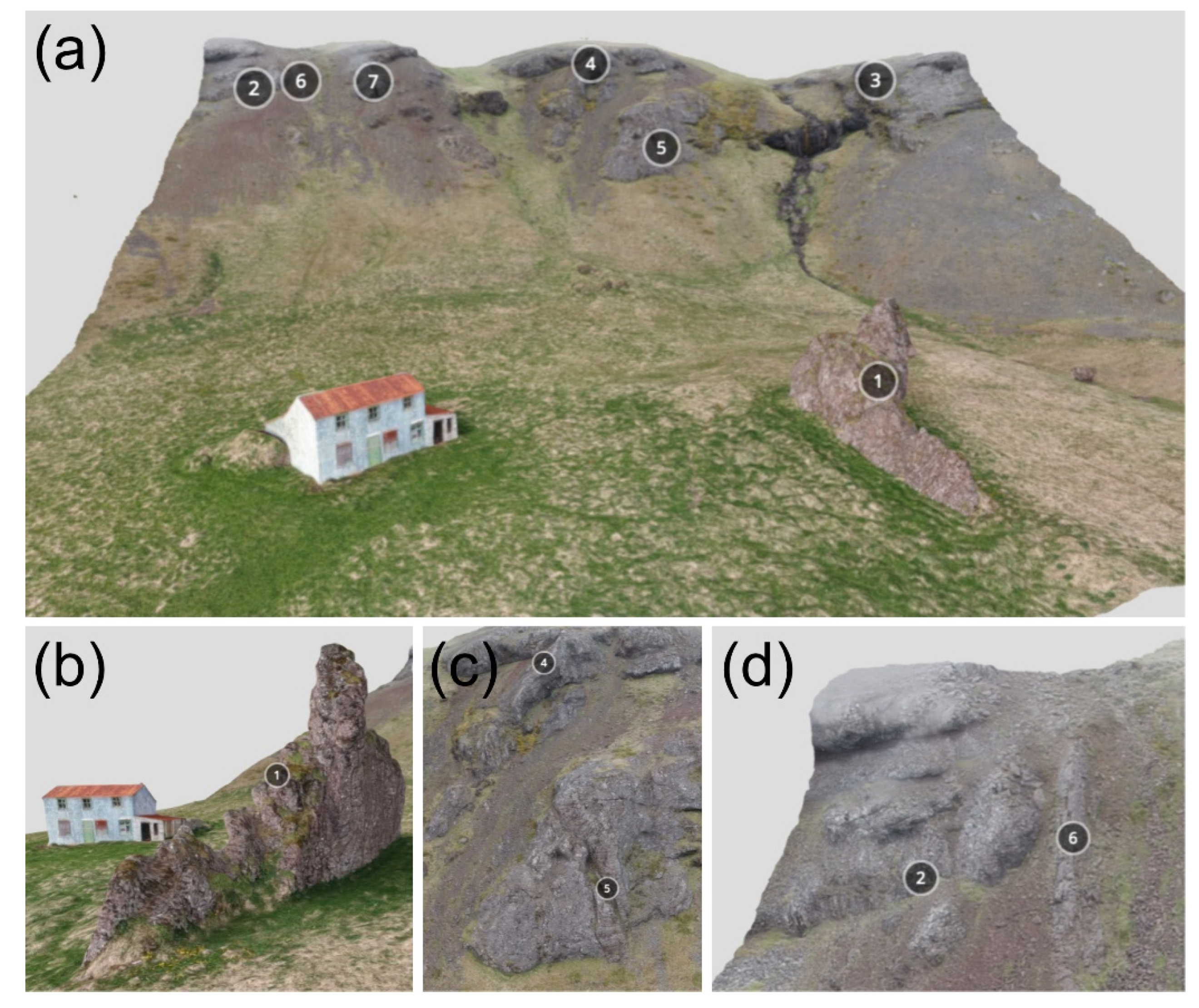
Virtual Geosite 4 (VG4), available at https://geovires.unimib.it/shallow-magma-bodies/smb_006/ (accessed on 14 February 2021), has an extent of 150 m × 180 m and the displayed area is located in eastern Iceland. The virtual geotour starts in the part of VG4 nearer to the stream, where a rectilinear, N 10°-striking, 1 m-thick dyke is made prominent by erosion (Figure 12, annotation 1). The dyke can be followed as far as a point (annotation 2) where it crosscuts a NW–SE-striking inclined sheet, as thick as 0.65 m (annotation 3). Moving across the trail, another dyke can be spotted, with a different strike from the previous one (trending NE–SW), and as thick as 1 m (annotation 4). This second dyke terminates in correspondence of a larger outcrop, made of a succession of gently inclined sills (annotation 5), stacked atop each other, and forming a half-flower intrusive structure [47]. The sills are affected by widespread columnar jointing. Based on the geometry of the columnar joints and on the discontinuities that separate each single sill (columns are perpendicular to the basal and upper surface of an originally planar intrusion), it is possible to infer an inclination of the sills of about 10°; the succession of sills would originally have been horizontal and was tilted later on by tectonic processes.
5.5. VG5: Cross-Cutting Relationships between Sills and Dykes
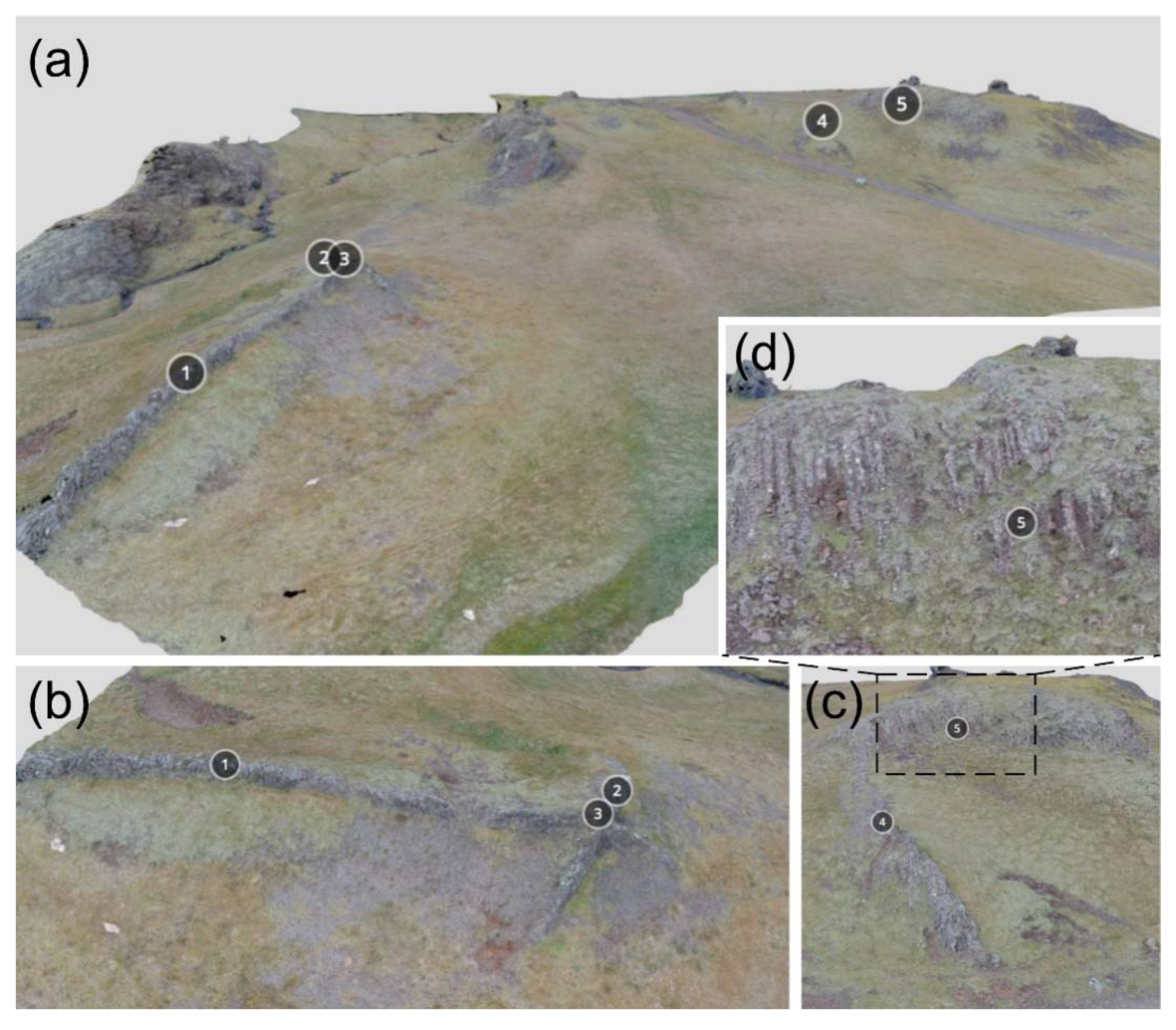
Virtual Geosite 5 (VG5), available at https://geovires.unimib.it/shallow-magma-bodies/smb_005/ (accessed on 14 February 2021), covers a roughly 100 m × 80 m-wide area; the cliff is composed of a succession of horizontal, Tertiary basaltic lava flows (Figure 13, annotation 1), intruded by five, 1.5 m-thick vertical dykes striking generally NE–SW, as well as by a horizontal, 1.3 m-thick sill, which is parallel to the lava flows. Zooming in, in correspondence of the cross-cutting contact between the sill and the dykes (annotation 3), it is possible to observe that the sill interrupts the continuity of the dykes. This clearly suggests that the former is more recent than the dyke intrusions.
6. Qualitative Assessment of the Selected Virtual Geosites (VGs)
All the VGs considered and described in the present work are related to the volcanic type, because they were produced in an ancient volcanic system. Moreover, they are circumscribed landforms, and this makes it easier to carry out observations and assess their overall value. Their relevance is local, because they are typical products of the Icelandic volcanism, although the processes that can be observed in the VGs are the same as those that can be observed in many other volcanic areas in the world, such as the Isle of Skye in Scotland [49,50]. All the considered VGs are representative of inactive processes, because they are located within an extinct volcanic system in eastern Iceland. Regarding their representativeness, all five VGs are fully representative of a number of subvolcanic and tectonic processes; however, there is no current scientific knowledge about all these geosites, because no study has addressed them up to the present work. Regarding rarity, we wish to emphasize that VG2 and VG4 host very uncommon features: at VG2, the intrusion of an inclined sheet along a normal fault can be observed, which is a process that can hardly ever be seen in the field. At VG4, the deflection of a dyke into a stack of sills is representative of an extremely rare process in Iceland and worldwide, namely, the formation of a half-flower intrusive structure, a feature that, up to now, was observed only in south-western Iceland. Concerning one of the so-called “additional values”, i.e., the educational value, all the selected VGs can be used to effectively explain and popularize peculiar processes that are typical of the subvolcanic environment. Finally, our approach is aimed at targeting a large number of end-users, of different ages, with the simplest way possible, because all VGs are made accessible through all classical devices, including mobile phones and tablets. This is different from other approaches, mainly based on stand-alone immersive VR PC-based systems [2,4,5], which are more expensive and where an ad hoc designed software is required; incidentally, the latter approach can offer a better experience in terms of immersivity and user interaction.
7. Conclusions
In this work, we have illustrated an approach for making geological features available to the general public at the worldwide level. We have shown the methodology for building up VOs and have introduced here, for the first time, the concept of “Virtual Geosites”, that can be key to popularizing and explaining geological processes to viewers who can remotely access and navigate through outcrops, as if they were physically in the field. To show the peculiarity and usefulness of this approach, we have chosen VGs belonging to extinct volcanic systems in eastern Iceland. Such VGs belong to the category of subvolcanic bodies, which are hardly ever considered as suitable for popularization. We have thoroughly described the five VGs, in a “virtual geotour mode” and made them available online, so as to enable the readers to access them and, based on our description, gain a deeper knowledge of subvolcanic bodies and processes. Finally, we have made a brief assessment of the five VGs and emphasized their major educational value. We do believe that our work could represent a model for future, similar efforts aimed at popularizing Earth Sciences and making geoheritage available to a broad public through VGs. Finally, we wish to stress that we could not investigate the possible outcomes of our methodology in terms of its educational impact, because this is outside the scope of the present paper. However, this is a topic worth exploring, through future work dedicated to looking into the potential educational impact of VGs and similar research efforts on the general public.
Author Contributions
Both authors have contributed to the manuscript; in particular, F.P.M. focused on the geological background and geoheritage sections; F.L.B. focused on virtual outcrop preparation and description. Both authors have read and agreed to the published version of the manuscript.
Funding
Funding was provided by the Dept. of Human and Innovation Sciences, Insubria University, Italy.
Institutional Review Board Statement
Not applicable.
Informed Consent Statement
Not applicable.
Data Availability Statement
No new data were created or analyzed in this study. Data sharing is not applicable to this article.
Acknowledgments
We would like to thank two anonymous reviewers for their very helpful comments and suggestions on an earlier version of the manuscript. This study has been conducted in the framework of the International Lithosphere Program-Task Force II and it is also an outcome of: (i) Project MIUR—Dipartimenti di Eccellenza 2018–2022; (ii) GeoVires, the Virtual Reality Lab for Earth Sciences, Department of Earth and Environmental Sciences, University of Milan Bicocca, Italy (https://geovires.unimib.it/ (accessed on 11 February 2021)). Finally, Agisoft Metashape is acknowledged for photogrammetric data processing.
Conflicts of Interest
The authors declare no conflict of interest.
References
- Krokos, M.; Bonali, F.L.; Vitello, F.; Varvara, A.; Becciani, U.; Russo, E.; Marchese, F.; Fallati, L.; Nomikou, P.; Kearl, M.; et al. Workflows for virtual reality visualisation and navigation scenarios in earth sciences. In Proceedings of the 5th International Conference on Geographical Information Systems Theory, Applications and Management, Heraklion, Crete, Greece, 3–5 May 2019; SciTePress: Setùbal, Portugal, 2019; pp. 297–304. [Google Scholar]
- Tibaldi, A.; Bonali, F.L.; Vitello, F.; Delage, E.; Nomikou, P.; Antoniou, V.; Becciani, U.; Van Wyk de Vries, B.; Krokos, M.; Whitworth, M. Real world–based immersive Virtual Reality for research, teaching and communication in volcanology. Bull. Volcanol. 2020, 82, 1–12. [Google Scholar] [CrossRef]
- Edler, D.; Keil, J.; Wiedenlübbert, T.; Sossna, M.; Kühne, O.; Dickmann, F. Immersive VR Experience of Redeveloped Post-Industrial Sites: The Example of “Zeche Holland” in Bochum-Wattenscheid. J. Cartogr. Geogr. Inf. 2019, 69, 267–284. [Google Scholar] [CrossRef] [Green Version]
- Lütjens, M.; Kersten, T.; Dorschel, B.; Tschirschwitz, F. Virtual Reality in Cartography: Immersive 3D Visualization of the Arctic Clyde Inlet (Canada) Using Digital Elevation Models and Bathymetric Data. MTI 2019, 3, 9. [Google Scholar] [CrossRef] [Green Version]
- Trinks, I.; Clegg, P.; McCaffrey, K.; Jones, R.; Hobbs, R.; Holdsworth, B.; Holliman, N.; Imber, J.; Waggott, S.; Wilson, R. Mapping and analysing virtual outcrops. Visual Geosci. 2005, 10, 13–19. [Google Scholar] [CrossRef]
- Pasquaré Mariotto, F.; Bonali, F.L.; Venturini, C. Iceland, an open-air museum for geoheritage and Earth science communication purposes. Resources 2020, 9, 14. [Google Scholar] [CrossRef] [Green Version]
- Chang, S.C.; Hsu, T.C.; Jong, M.S.Y. Integration of the peer assessment approach with a virtual reality design system for learning earth science. Comput. Educ. 2020, 146, 103758. [Google Scholar] [CrossRef]
- Eberhard, R. Pattern and Process: Towards a Regional Approach to National Estate Assessment of Geodiversity; Eberhard, R., Ed.; Environment Australia: Canberra, Australia, 1997. [Google Scholar]
- Brocx, M.; Semeniuk, V. Geoheritage and geoconservation history, definition, scope and scale. J. R. Soc. West. Aust. 2007, 90, 53–87. [Google Scholar]
- Asrat, A.; Demissie, M.; Mogessie, A. Geoheritage conservation in Ethiopia: The case of the Simien mountains. Quaest. Geogr. 2012, 31, 7–23. [Google Scholar] [CrossRef] [Green Version]
- Fassoulas, C.; Mouriki, D.; Dimitriou-Nikolakis, P.; Iliopoulos, G. Quantitative assessment of geotopes as an effective tool for geoheritage management. Geoheritage 2012, 4, 177–193. [Google Scholar] [CrossRef]
- Wimbledon, W.A.P.; Smith-Meyer, S. Geoheritage in Europe and Its Conservation; Wimbledon, W.A.P., Smith-Meyer, S., Eds.; ProGEO: Oslo, Norwey, 2012; p. 405. [Google Scholar]
- Bruno, D.E.; Crowley, B.E.; Gutak, J.M.; Moroni, A.; Nazarenko, O.V.; Oheim, K.B.; Ruban, D.A.; Tiess, G.; Zorina, S.O. Paleogeography as geological heritage: Developing geosite classification. Earth Sci. Rev. 2014, 138, 300–312. [Google Scholar] [CrossRef]
- Brilha, J. Inventory and quantitative assessment of geosites and geodiversity sites: A review. Geoheritage 2016, 8, 119–134. [Google Scholar] [CrossRef] [Green Version]
- Reis, J.; Póvoas, L.; Barriga, F.J.A.S.; Lopes, C. Science education in a museum: Enhancing Earth Sciences literacy as a way to enhance public awareness of geological heritage. Geoheritage 2014, 6, 217–223. [Google Scholar] [CrossRef]
- Pasquaré Mariotto, F.; Venturini, C. Strategies and tools for improving Earth Science education and popularization in museums. Geoheritage 2017, 9, 187–194. [Google Scholar] [CrossRef]
- Venturini, C.; Pasquaré Mariotto, F. Geoheritage promotion through an interactive exhibition: A case study from the Carnic Alps, NE Italy. Geoheritage 2019, 11, 459–469. [Google Scholar] [CrossRef]
- De Grosbois, A.M.; Eder, W. Geoparks. A tool for education, conservation and recreation. Environ. Geol. 2008, 55, 465–466. [Google Scholar] [CrossRef]
- Mckeever, P.; Zouros, N.; Patzak, M. The UNESCO global network of national geoparks. In Geotourism. The Tourism of Geology and Landscape; Newsome, D., Dowling, R.K., Eds.; Goodfellow Publishers Ltd.: Oxford, UK, 2010; pp. 221–230. [Google Scholar]
- Pásková, M.; Zelenka, J. Sustainability management of unesco global geoparks. Sustain. Geosci. Geotourism 2018, 2, 44–64. [Google Scholar] [CrossRef]
- Panizza, M.; Piacente, S. Geomorphosites and geotourism. Rev. Geog. Acad. 2008, 2, 5–9. [Google Scholar]
- Newsome, D.; Dowling, R.K. Geotourism: The Tourism of Geology and Landscape; Goodfellow Publishers Ltd.: Oxford, UK, 2010. [Google Scholar]
- Burek, C.V. The role of LGAPs (Local Geodiversity Action Plans) and Welsh RIGS as local drivers for geoconservation within geotourism in Wales. Geoheritage 2012, 4, 45–63. [Google Scholar] [CrossRef]
- Kubalíková, L. Geomorphosite assessment for geotourism purposes. Czech J. Tour. 2013, 2, 80–104. [Google Scholar] [CrossRef]
- Suzuki, A.; Takagi, H. Evaluation of geosite for sustainable planning and management in Geotourism. Geoheritage 2018, 10, 123–135. [Google Scholar] [CrossRef]
- Grandgirard, V. L’évaluation des géotopes. Geol. Insubr. 1999, 4, 59–66. [Google Scholar]
- Becerra-Ramírez, R.; Gosálvez, R.U.; Escobar, E.; González, E.; Serrano-Patón, M.; Guevara, D. Characterization and Geotourist Resources of the Campo de Calatrava Volcanic Region (Ciudad Real, Castilla-La Mancha, Spain) to Develop a UNESCO Global Geopark Project. Geosciences 2020, 10, 441. [Google Scholar] [CrossRef]
- Beltrán-Yanes, E.; Dóniz-Páez, J.; Esquivel-Sigut, I. Chinyero Volcanic Landscape Trail (Canary Islands, Spain): A Geotourism Proposal to Identify Natural and Cultural Heritage in Volcanic Areas. Geosciences 2020, 10, 453. [Google Scholar] [CrossRef]
- Carrión-Mero, P.; Montalván-Burbano, N.; Paz-Salas, N.; Morante Carballo, F. Volcanic Geomorphology: A Review of Worldwide Research. Geosciences 2020, 10, 347. [Google Scholar] [CrossRef]
- Dóniz-Páez, J.; Beltrán-Yanes, E.; Becerra-Ramírez, R.; Pérez, N.M.; Hernández, P.A.; Hernández, W. Diversity of Volcanic Geoheritage in the Canary Islands, Spain. Geosciences 2020, 10, 390. [Google Scholar] [CrossRef]
- Megerle, H.E. Geoheritage and Geotourism in Regions with Extinct Volcanism in Germany; Case Study Southwest Germany with UNESCO Global Geopark Swabian Alb. Geosciences 2020, 10, 445. [Google Scholar] [CrossRef]
- Quesada-Román, A.; Pérez-Umaña, D. State of the Art of Geodiversity, Geoconservation, and Geotourism in Costa Rica. Geosciences 2020, 10, 211. [Google Scholar] [CrossRef]
- Ureta, G.; Németh, K.; Aguilera, F.; González, R. Features That Favor the Prediction of the Emplacement Location of Maar Volcanoes: A Case Study in the Central Andes, Northern Chile. Geosciences 2020, 10, 507. [Google Scholar] [CrossRef]
- Parkes, M.; Gatley, S.; Gallagher, V. Old Volcanic Stories—Bringing Ancient Volcanoes to Life in Ireland’s Geological Heritage Sites. Geosciences 2021, 11, 52. [Google Scholar] [CrossRef]
- Santo, A.P. A New Magma Type in the Continental Collision Zone. The Case of Capraia Island (Tuscany, Italy). Geosciences 2021, 11, 104. [Google Scholar] [CrossRef]
- Vörös, F.; Pál, M.; van Wyk de Vries, B.; Székely, B. Development of Geodiversity System for the Scoria Cones of the Chaîne des Puys Based on Geomorphometric Studies. Geosciences 2021, 11, 58. [Google Scholar] [CrossRef]
- Zorina, S.O.; Silantiev, V.V. Geosites, Classification of. In Encyclopedia of Mineral and Energy Policy; Springer: Berlin/Heidelberg, Germany, 2014. [Google Scholar]
- Ruban, D.A. Quantification of geodiversity and its loss. Proc. Geol. Assoc. 2010, 121, 326–333. [Google Scholar] [CrossRef]
- Lima, F.; Brilha, J.; Salamuni, E. Inventorying geological heritage in large territories: A methodological proposal applied to Brazil. Geoheritage 2010, 2, 91–99. [Google Scholar] [CrossRef] [Green Version]
- Reynard, E.; Fontana, G.; Kozlik, L.; Scapozza, C. A method for assessing “scientific” and “additional values” of geomorphosites. Geogr. Helv. 2007, 62, 148–158. [Google Scholar] [CrossRef]
- Coratza, P.; Giusti, C. Methodological proposal for the assessment of the scientific quality of of geomorphosites. Il Quat. 2005, 18, 307–313. [Google Scholar]
- Coratza, P.; Panizza, M. Geomorphology and Cultural Heritage; Memorie Descrittive Della Carta Geologica d’Italia; Coratza, P., Panizza, M., Eds.; ISPRA: Rome, Italy, 2009; p. 87. [Google Scholar]
- Gudmundsson, A. Deflection of dykes into sills at discontinuities and magma-chamber formation. Tectonophyisics 2011, 500, 50–64. [Google Scholar] [CrossRef]
- Gudmundsson, A.; Pasquarè Mariotto, F.; Tibaldi, A. Dykes, Sills, Laccoliths, and Inclined Sheets in Iceland. In Physical Geology of Shallow Magmatic Systems; Breitkreutz, C., Rocchi, S., Eds.; Springer: Cham, Germany, 2014. [Google Scholar]
- Tibaldi, A. Structure of volcano plumbing systems: A review of multi-parametric effects. J. Volcanol. Geoth. Res. 2015, 298, 85–135. [Google Scholar] [CrossRef]
- Tibaldi, A.; Vezzoli, L.; Pasquaré Mariotto, F.; Rust, D. Strike-slip fault tectonics and the emplacement of sheet-laccolith systems: The Thverfell case study (SW Iceland). J. Struct. Geol. 2008, 30, 274–290. [Google Scholar] [CrossRef]
- Tibaldi, A.; Pasquaré Mariotto, F. A new mode of inner volcano growth: The “flower intrusive structure”. Earth Planet. Sci. Lett. 2008, 271, 202–208. [Google Scholar] [CrossRef]
- Tibaldi, A.; Bonali, F.L.; Pasquaré Mariotto, F.; Rust, D.; Cavallo, A.; D’Urso, A. Structure of regional dykes and local cone sheets in the Midhyrna-Lysuskard area, Snaefellsnes Peninsula (NW Iceland). Bull. Volcanol. 2013, 75, 764–780. [Google Scholar] [CrossRef]
- Tibaldi, A.; Pasquaré Mariotto, F.; Rust, D. New insights into the cone-sheet structure of the Cuillin Complex, Isle of Skye, Scotland. J. Geol. Soc. 2011, 168, 689–704. [Google Scholar] [CrossRef]
- Bistacchi, A.; Tibaldi, A.; Pasquaré Mariotto, F.; Rust, D. The association of cone-sheets and radial dykes: Data from the Isle of Skye (UK), numerical modelling, and implications for shallow magma chambers. Earth Planet. Sci. Lett. 2012, 339–340, 46–56. [Google Scholar] [CrossRef]
- Sæmundsson, K. Outline of the geology of Iceland. Jokull 1979, 29, 7–28. [Google Scholar]
- Jóhannesson, H. Jardlagaskipan of throun rekbleta a Vesturlandi. (Evolution of rift zones in western Iceland). Natturufraedingurinn Reyk. 1980, 50, 13–31. [Google Scholar]
- Vink, G.E. A hotspot model for Iceland and the Vøring Plateau. J. Geophys. Res. Solid Earth 1984, 89, 9949–9959. [Google Scholar] [CrossRef]
- Oskarsson, N.; Steinthorsson, S.; Sigvaldason, G.E. Iceland geochemical anomaly: Origin, volcanotectonics, chemical fractionation and isotope evolution of the crust. J. Geophys. Res. Solid Earth 1985, 90, 10011–10025. [Google Scholar] [CrossRef]
- Hardarson, B.S.; Fitton, J.G.; Ellam, R.M.; Pringle, M.S. Rift relocation—A geochemical and geochronological investigation of a palaeo-rift in northwest Iceland. Earth Planet. Sci. Lett. 1997, 153, 181–196. [Google Scholar] [CrossRef]
- Gudmundsson, A. Dynamics of volcanic systems in Iceland: Example of tectonism and volcanism at juxtaposed hot spot and mid-ocean ridge systems. Ann. Rev. Earth Planet. Sci. 2000, 28, 107–140. [Google Scholar] [CrossRef]
- Thordarson, T.; Larsen, G. Volcanism in Iceland in historical time: Volcano types, eruption styles and eruptive history. J. Geodyn. 2007, 43, 118–152. [Google Scholar] [CrossRef]
- Paquet, F.; Dauteuil, O.; Hallot, E.; Moreau, F. Tectonics and magma dynamics coupling in a dyke swarm of Iceland. J. Struct. Geol. 2007, 29, 1477–1493. [Google Scholar] [CrossRef]
- Gudmundsson, A. Dyke emplacement at divergent plate boundary. In Mafic Dykes Emplacement Mechanisms; Parker, A.J., Rickwood, P.C., Tucker, D.H., Eds.; Balkema: Rotterdam, The Netherlands, 1990; pp. 47–62. [Google Scholar]
- Gudmundsson, A. Infrastructure and mechanisms of volcanic systems in Iceland. J. Volcanol. Geotherm. Res. 1995, 64, 1–22. [Google Scholar] [CrossRef]
- Gudmundsson, A. The geometry and growth of dykes. In Physics and Chemistry of Dykes; Baer, G., Heimann, A., Eds.; Balkema: Rotterdam, The Netherlands, 1995; pp. 23–34. [Google Scholar]
- Gudmundsson, A. Magma chambers modeled as cavities explain the formation of rift zone central volcanoes and their eruption and intrusion statistics. J. Geophys. Res. 1998, 103, 7401–7412. [Google Scholar] [CrossRef]
- Gudmundsson, A. Emplacement and arrest of sheets and dykes in central volcanoes. J. Volcanol. Geotherm. Res. 2002, 116, 279–298. [Google Scholar] [CrossRef]
- Bourgeois, O.; Dauteuil, O.; Hallot, E. Rifting above a mantle plume: The Icelandic Plateau. Geodin. Acta 2005, 18, 59–80. [Google Scholar] [CrossRef] [Green Version]
- Klausen, M.B. Geometry and mode of emplacement of dike swarms around the Birnudalstindur igneous centre, SE Iceland. J. Volcanol. Geotherm. Res. 2006, 151, 340–356. [Google Scholar] [CrossRef]
- Neuhoff, P.S.; Fridriksson, T.; Arnorsson, S.; Brid, D.K. Porosity evolution and mineral paragneiss during low-grade metamorphism of basaltic lavas at Teigarhorn, eastern Iceland. Am. J. Sci. 1999, 299, 467–501. [Google Scholar] [CrossRef] [Green Version]
- Etzelmüller, B.; Patton, H.; Schomacker, A.; Czekirda, J.; Girod, L.; Hubbard, A.; Lilleøren, K.S.; Westermann, S. Icelandic permafrost dynamics since the Last Glacial Maximum—Model results and geomorphological implications. Quat. Sci. Rev. 2020, 233, 106236. [Google Scholar] [CrossRef]
- Walker, G.P.L. The structure of eastern Iceland. In Geodynamics of Iceland and the North Atlantic Area; Kristjansson, L., Ed.; D. Reidel Publishing: Dordrecht, The Netherlands, 1974; pp. 177–188. [Google Scholar]
- Gudmundsson, A. Form and dimensions of dykes in eastern Iceland. Tectonophysics 1983, 95, 295–307. [Google Scholar] [CrossRef]
- Johannesson, H.; Saemundsson, K. Bedrock Geology, Geological Map of Iceland, Scale 1:500,000; Icelandic Institute of Natural History: Reykjavik, Iceland, 1998. [Google Scholar]
- Bonali, F.L.; Tibaldi, A.; Marchese, F.; Fallati, L.; Russo, E.; Corselli, C.; Savini, A. UAV-based surveying in volcano-tectonics: An example from the Iceland rift. J. Struct. Geol. 2019, 121, 46–64. [Google Scholar] [CrossRef]
- Bonali, F.L.; Tibaldi, A.; Corti, N.; Fallati, L.; Russo, E. Reconstruction of Late Pleistocene-Holocene Deformation through Massive Data Collection at Krafla Rift (NE Iceland) Owing to Drone-Based Structure-from-Motion Photogrammetry. Appl. Sci. 2020, 10, 6759. [Google Scholar] [CrossRef]
- Antoniou, V.; Bonali, F.L.; Nomikou, P.; Tibaldi, A.; Melissinos, P.; Mariotto, F.P.; Vitello, F.R.; Krokos, M.; Whitworth, M. Integrating Virtual Reality and GIS Tools for Geological Mapping, Data Collection and Analysis: An Example from the Metaxa Mine, Santorini (Greece). Appl. Sci. 2020, 10, 8317. [Google Scholar] [CrossRef]
- Stal, C.; Bourgeois, J.; De Maeyer, P.; De Mulder, G.; De Wulf, A.; Goossens, R.; Hendrickx, M.; Nuttens, T.; Stichelbaut, B. Test case on the quality analysis of structure from motion in airborne applications. In Proceedings of the 32nd EARSeL Symposium: Advances in Geosciences, Mykonos, Greece, 21–24 May 2012; p. 11. [Google Scholar]
- Westoby, M.J.; Brasington, J.; Glasser, N.F.; Hambrey, M.J.; Reynolds, J.M. Structure-from-Motion’photogrammetry: A low-cost, effective tool for geoscience applications. Geomorphology 2012, 179, 300–314. [Google Scholar] [CrossRef] [Green Version]
- Bonali, F.L.; Antoniou, V.; Vlasopoulos, O.; Tibaldi, A.; Nomikou, P. Selfie Drones for 3D Modelling, Geological Mapping and Data Collection: Key Examples from Santorini Volcanic Complex, Greece. In Proceedings of the 6th International Conference on Geographical Information Systems Theory, Applications and Management (GISTAM 2020), Online, 7–9 May 2020; pp. 119–128. [Google Scholar]
- Varvara, A.; Nomikou, P.; Pavlina, B.; Pantelia, S.; Bonali, F.L.; Lemonia, R.; Andreas, M. The story map for Metaxa mine (Santorini, Greece): A unique site where history and volcanology meet each other. In Proceedings of the 5th International Conference on Geographical Information Systems Theory, Applications and Management (GISTAM 2019), Heraklion, Crete, Greece, 3–5 May 2019; pp. 3–5. [Google Scholar]
- Vollgger, S.A.; Cruden, A.R. Mapping folds and fractures in basement and cover rocks using UAV photogrammetry, Cape Liptrap and Cape Paterson, Victoria, Australia. J. Struct. Geol. 2016, 85, 168–187. [Google Scholar] [CrossRef]
- Burns, J.H.R.; Delparte, D. Comparison of commercial structure-from-motion photogrammety software used for underwater three-dimensional modeling of coral reef environments. Int. Arch. Photogramm. Remote Sens. Spat. Inf. Sci. 2017, 42, 127. [Google Scholar] [CrossRef] [Green Version]
- James, M.R.; Robson, S. Straightforward reconstruction of 3D surfaces and topography with a camera: Accuracy and geoscience application. J. Geophys. Res. Earth Surf. 2012, 117. [Google Scholar] [CrossRef] [Green Version]
- James, M.R.; Robson, S.; Smith, M.W. 3-D uncertainty-based topographic change detection with structure-from-motion photogrammetry: Precision maps for ground control and directly georeferenced surveys. Earth Surf. Process. Landf. 2017, 42, 1769–1788. [Google Scholar] [CrossRef]
- Miyahara, K.; Okada, Y. COLLADA-based File Format Supporting Various Attributes of Realistic Objects for VR Applications. In Proceedings of the 2009 International Conference on Complex, Intelligent and Software Intensive Systems, Fukuoka, Japan, 16–19 March 2009; IEEE: New York, NY, USA, 2009; pp. 971–976. [Google Scholar]
- Gerloni, I.G.; Carchiolo, V.; Vitello, F.R.; Sciacca, E.; Becciani, U.; Costa, A.; Riggi, S.; Bonali, F.L.; Russo, E.; Fallati, L.; et al. Immersive virtual reality for earth sciences. In Proceedings of the 2018 Federated Conference on Computer Science and Information Systems (FedCSIS), Poznan, Poland, 9–12 September 2018; IEEE: New York, NY, USA, 2018; pp. 527–534. [Google Scholar]
- Cawood, A.J.; Bond, C.E. eRocK: An online, open-access repository of virtual outcrops and geological samples in 3D. In Proceedings of the EGU General Assembly Conference Abstracts, Vienna, Austria, 8–13 April 2018; Volume 20, p. 18248. [Google Scholar]
- Choi, D.H.; Dailey-Hebert, A.; Estes, J.S. Emerging Tools and Applications of Virtual Reality in Education; Choi, D.H., Dailey-Hebert, A., Estes, J.S., Eds.; Information Science Reference: Hershey, PA, USA, 2016. [Google Scholar]
- Pasquaré Mariotto, F.; Tibaldi, A. Structure of a sheet-laccolith system revealing the interplay between tectonic and magma stresses at Stardalur Volcano, Iceland. J. Volcanol. Geotherm. Res. 2007, 161, 131–150. [Google Scholar] [CrossRef]
Figure 1.
The main volcano-tectonic rift zones of Iceland (black lines); the distribution and age of the main geological formation is also highlighted (redrawn from Thordarson and Larsen [57]). Yellow circles locate the outcrops illustrated in this work, all belonging to the Tertiary basalt formation.

Figure 2.
(a) Example of typical dykes cutting the Tertiary basalt formation in the Berufjordur valley, car for scale. (b) Detailed map of a portion of eastern Iceland, showing 4 out of 5 sites presented in this study, which belong to the Alftarfjordur ancient volcanic system; lava tilting is shown by black arrows; the figure is adapted from Paquet et al. [58].

Figure 3.
(a) The 0.300 kg unmanned aerial vehicle (UAV) used in the present work, equipped with propeller guards; person for scale. (b) Example of UAV-collected pictures with both nadir and oblique camera orientation.
Figure 3.
(a) The 0.300 kg unmanned aerial vehicle (UAV) used in the present work, equipped with propeller guards; person for scale. (b) Example of UAV-collected pictures with both nadir and oblique camera orientation.

Figure 4.
Example of UAV-collected picture with nadir camera orientation (a), and where a mask to exclude the sky from processing has been applied (b).
Figure 4.
Example of UAV-collected picture with nadir camera orientation (a), and where a mask to exclude the sky from processing has been applied (b).

Figure 5.
(a) Example of sparse and (b) dense cloud obtained by applying the above-mentioned workflow, including a “Filter by confidence” tool.
Figure 5.
(a) Example of sparse and (b) dense cloud obtained by applying the above-mentioned workflow, including a “Filter by confidence” tool.

Figure 6.
(a) Output regarding the 3D model: DAE file for the mesh and the two JPG files of the texture feature. (b) Final version of the 3D model.
Figure 6.
(a) Output regarding the 3D model: DAE file for the mesh and the two JPG files of the texture feature. (b) Final version of the 3D model.

Figure 7.
Example of an annotated virtual outcrop (VO) made available to the public showing shallow magma bodies (a,b) in eastern Iceland.
Figure 7.
Example of an annotated virtual outcrop (VO) made available to the public showing shallow magma bodies (a,b) in eastern Iceland.

Figure 8.
(a) The virtual geosite (VG) can be viewed through specially dedicated goggles and (b) navigated with the aid of joysticks. (c) Example of an annotated 3D model where the viewer’s starting point and the height have been set up, as well as the direction of observation.
Figure 8.
(a) The virtual geosite (VG) can be viewed through specially dedicated goggles and (b) navigated with the aid of joysticks. (c) Example of an annotated 3D model where the viewer’s starting point and the height have been set up, as well as the direction of observation.

Figure 9.
(a) Overall view of the 3D model; the group of country houses is for scale. Numbers are interactive annotations that can be clicked online, providing the viewer with explanations about particularly relevant features; (b) detail of the laccolith, with the thick columnar joints well visible; (c) a 7 m-thick dyke cutting through the lava succession; (d) close-up view of the columnar joints that bend to attain a shallower dip.

Figure 10.
(a) Overall view of the 3D model. Numbers are interactive annotations that can be clicked online, providing the viewer with explanations about particularly relevant features. (b) Detail of the inclined sheet, which has intruded along a dip-slip (normal) fault that has produced a downthrow of about 5 m of the lava succession to the right-hand side of the model.

Figure 11.
(a) Overall view of the 3D model. Numbers are interactive annotations that can be clicked online, providing the viewer with explanations about particularly relevant features; (b) detail of the towering dyke (house for scale); (c) focus on the inclined sheet (annotation 4) and the subvertical dyke (annotation 5); (d) the lava succession that represents the host rock, within which all the subvolcanic bodies have been emplaced (annotation 2), cut by a vertical dyke (annotation 6).

Figure 12.
(a) Overall view of the 3D model. Numbers are interactive annotations that can be clicked online, providing the viewer with explanations about particularly relevant features; (b) detail of the cross-cutting relationship (annotation 2) between a dyke and an inclined sheet; (c) a dyke (annotation 4) abruptly turning into a succession of sills, stacked atop each other; (d) focus on the sills (annotation 5), featuring an outstanding columnar jointing.

Figure 13.
(a) Overall view of the 3D model. Numbers are interactive annotations that can be clicked online, providing the viewer with explanations about particularly relevant features; (b) detail of the vertical cliff, showing the horizontal lava bedding on top, as well as a number of dykes (examples at annotations 4 and 5). The crosscutting relationship (annotation 3) between the sill and the dyke clearly shows that the sill was emplaced later than the dyke.

Publisher’s Note: MDPI stays neutral with regard to jurisdictional claims in published maps and institutional affiliations. |
© 2021 by the authors. Licensee MDPI, Basel, Switzerland. This article is an open access article distributed under the terms and conditions of the Creative Commons Attribution (CC BY) license (http://creativecommons.org/licenses/by/4.0/).
Share and Cite
MDPI and ACS Style
Pasquaré Mariotto, F.; Bonali, F.L. Virtual Geosites as Innovative Tools for Geoheritage Popularization: A Case Study from Eastern Iceland. Geosciences 2021, 11, 149. https://0-doi-org.brum.beds.ac.uk/10.3390/geosciences11040149
AMA Style
Pasquaré Mariotto F, Bonali FL. Virtual Geosites as Innovative Tools for Geoheritage Popularization: A Case Study from Eastern Iceland. Geosciences. 2021; 11(4):149. https://0-doi-org.brum.beds.ac.uk/10.3390/geosciences11040149
Chicago/Turabian StylePasquaré Mariotto, Federico, and Fabio Luca Bonali. 2021. "Virtual Geosites as Innovative Tools for Geoheritage Popularization: A Case Study from Eastern Iceland" Geosciences 11, no. 4: 149. https://0-doi-org.brum.beds.ac.uk/10.3390/geosciences11040149
Note that from the first issue of 2016, this journal uses article numbers instead of page numbers. See further details here.