Article

Spatial Transformation of a New City in 2006–2020: Perspectives on the Spatial Dynamics, Environmental Quality Degradation, and Socio—Economic Sustainability of Local Communities in Makassar City, Indonesia

1
Department of Urban and Regional Planning, Faculty of Engineering, University Bosowa Makassar, Makassar City 90231, Indonesia
2
Department of Aquaculture, Faculty of Agriculture, University Bosowa Makassar, Makassar City 90231, Indonesia
3
Department of Financial Management, Faculty of Economic and Bussines, University Bosowa Makassar, Makassar City 90231, Indonesia
4
Department of Agricultural Socio-Economic, Faculty of Agriculture, University Bosowa Makassar, Makassar City 90231, Indonesia
5
Department of Agricultural Agribusiness, Faculty of Agriculture, University Bosowa Makassar, Makassar City 90231, Indonesia
6
Department of Accounting, Faculty of Economic and Business, University Bosowa Makassar, Makassar City 90231, Indonesia
7
Department of Urban Planning, Faculty of Engineering, University Bosowa Makassar, Makassar City 90231, Indonesia
*
Author to whom correspondence should be addressed.
Submission received: 9 August 2020 / Revised: 10 September 2020 / Accepted: 11 September 2020 / Published: 14 September 2020

Abstract

:
The accelerated development of new urban areas has an impact on changes in the spatial use and complexity of ecosystems. The purpose of this study is to analyze (1) spatial transformation works as a determinant of changes in the social formation of local communities in the new city area of Metro Tanjung Bunga; (2) process of social interaction and social adaptation between immigrants and local communities in new social formations in the new city area of Metro Tanjung Bunga; and (3) the effect of spatial use, changes in social formation, and work differentiation on the socio-economic sustainability of local communities. The research method used involves a combination of qualitative and quantitative approaches. Data were obtained by observation, in-depth interviews, surveys, and documentation. The results of the study show that spatial transformation has an impact on changing the single social formations of local communities into multiple social formations and transforming differences in modes of production between migrants and local communities into changes in the order of life of local communities. These changing interactions and social adaptations cause changes in the social structures and cultural patterns of local communities. Furthermore, changes in spatial use, social formation, and job differentiation have a significant effect on the socio-economic sustainability of local communities, with a coefficient of determination of 97.7%. This study recommends considering environmental, economic, and sociocultural factors followed by government decision-making for the future development of the new city area of Metro Tanjung Bunga, Makassar City.

1. Introduction

Cities are fundamentally social realities that cannot be disconnected from the rate of development of the era and the impact of the developing global economy. To measure the impact of globalization, five dimensions can be used: Economic factors, socio-economic factors, political factors, cultural factors, and city layout [1,2]. Social change at the micro-level of the community are part of the impact of economic development in suburban areas for the purpose of developing new urban areas. These conditions cause changes in the index of social trust among those in local communities. Consequently, the local communities who originally occupied the land often lose their rights over the property their livelihoods might have relied on [3,4]. The process of globalization and its impact on socio-economic factors can be observed in the high poverty rates and service gaps between cities. Thus, peri-urbanization involves a process of penetration from the city center to the transition area of rural land use towards urban land use [5,6].
Globalization for countries in Asia contributes positively to the development of democracy to achieve prosperity among the citizenry. However, it is for some of the developed markets of the Pacific region (Hong Kong and New Zealand), Europe (Ireland, Denmark, and Spain) and emerging markets of Asia (China), Europe (Czech Republic), and Americas (Argentina and Peru) at a medium-term horizon [7]. In different contexts, for example, China and Singapore have a tendency not to use democratic instruments to achieve the prosperity of their people but instead utilize the phenomenon of globalization, especially in the economic sector, to compete on the international stage. Globalization has also touched countries in Southeast Asia, with a variety of impacts on economic, political, and other social issues. In Southeast Asia, this phenomenon can be demonstrated by the fact that the rising globalization in Southeast Asia is not always followed by an increase in economic growth [8].
The development of large cities and metropolitan areas in Indonesia cannot be separated from the processes of globalization, technological advancement, and transportation. Social change at the community level has become a strategic study area for social scientists and provides an opportunity to understand the tendency to reconfigure social order [9]. City development will always be connected to ideal concepts and forms. The ideal shape of a city does not have to be the same between one urban area and another urban area. Furthermore, city spatial expressions have varying forms due to compounding differences in the typology, morphology, and variations in the physical environment. Consequently, it is very important to establish policies and strategies for planning housing supply and managing housing environments in low-rise residential areas [10,11]. Strong spatial physical engineering can direct the tendency of physical development to accelerate, slow down, stop, or divert the direction of the spatial development of a city. The main domains of spatial planning include efficient built-up development, the conservation of agricultural land, landscape preservation, and human perception [12,13].
The dynamics of the growth of Makassar City and its relationship to the allocation of space being developed shows symptoms of spatial segregation based on the socio-economic strata of the community. Urban segregation is an inherent feature of cities and becomes a problem when it excludes or hinders certain groups from accessing services, activities, and/or spaces [14]. Furthermore, residential segregation by race/ethnicity is widely recognized as a leading source of health disparities [15]. As such, the scope of Makassar City study is part of developing the Metropolitan Mamminasata urban area based on the Makassar–Maros–Gowa–Takalar planological deconcentration policy. The development of the city, which predominantly involves meeting the needs of housing and infrastructure, thus becomes a determinant for increasing accessibility, land use changes, and the conversion of productive agricultural land [16].
The dynamics of the development of the new city area of Metro Tanjung Bunga have had an impact on the conversion of productive agricultural land and have yielded changes in the typology, morphology, and structure of the region due to the complexity of the ecosystem. This structure is the result of the interactions of the multiple morphological elements representative of a city [17,18], and this condition is marked by a reduction of the agricultural land and pond areas that have been converted into urban activities. The transfer of land use functions in the new city area Metro Tanjung Bunga area has had a significant impact on changes in spatial use. This condition is marked by the presence of urban functions, including (1) recreational facilities, occupying an area of 29 hectares; (2) housing, occupying an area of 33.5 hectares; (3) agricultural land, which reduced from 889.14 hectares to 27.42 hectares; (4) ponds, which decreased in area from 108.4 hectares to 15 hectares; (5) mixed gardens, which decreased in area from 11.20 hectares to 5 hectares; and (6) 160 hectares of vacant land, which decreased to 85.32 hectares.
Various facilities were also developed, including (a) socio-economic facilities occupying an area of 17 hectares and (b) a road network of 17.8 km. Likewise, the development of the population has increased. The area was initially only inhabited by 4571 individuals in 1996. In 2008, this number increased by 52,803 inhabitants, in 2015, by as many as 179,152 people, and in 2019, the total was 189,893 inhabitants. These conditions indicate that population migration and suburbanization in the new city area of Metro Tanjung Bunga are positively associated with an increase in population related to typological changes, as well as to morphological changes in spatial use. Furthermore, the specialization of community activities closely related to formal urban activity patterns will require the support of people with sufficient expertise, skills, and educational backgrounds [19].
The focus of this study is to answer the following research questions: (1) How does spatial transformation work as a determinant of changes in the social formation of local communities in the new city area of Metro Tanjung Bunga? (2) How is the process of social interaction and social adaptation between immigrants and local communities in new social formations in the new city area of Metro Tanjung Bunga? (3) How do changes in spatial use, social formation, and job differentiation affect the socio-economic sustainability of the local community?

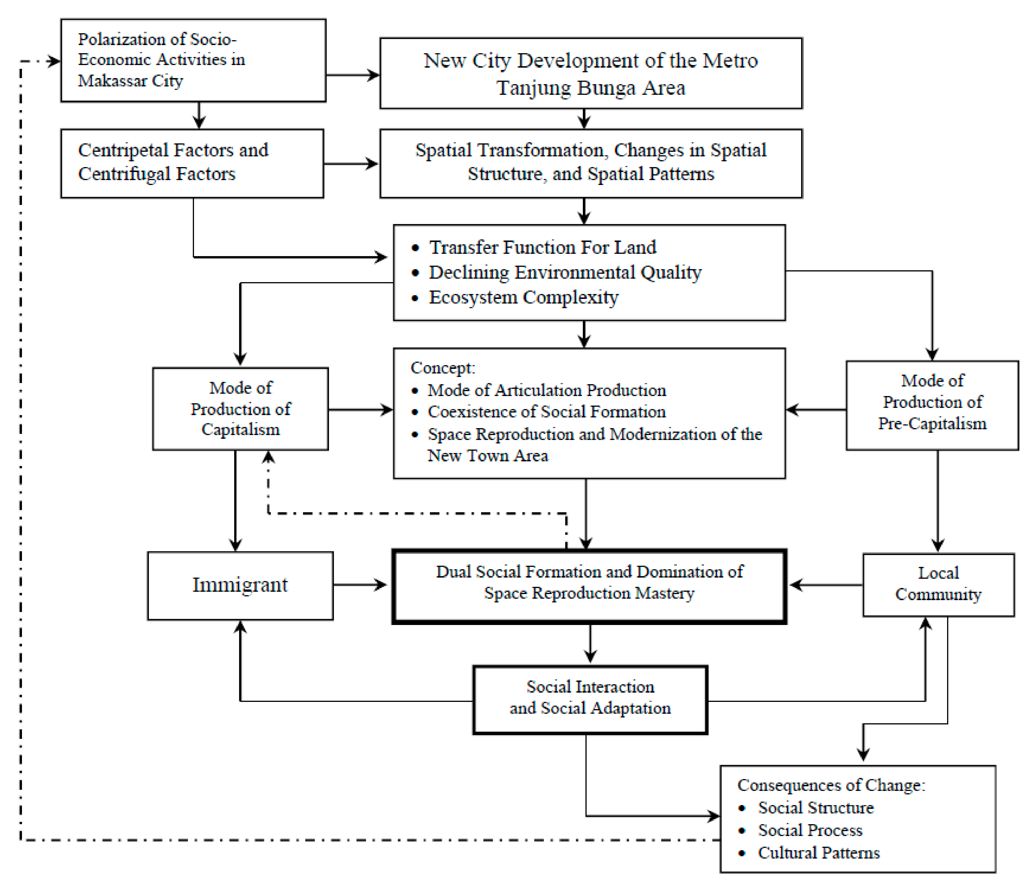
2. Conceptual Framework

The phenomenon of spatial physical change as a determinant of changes in the social formation of the local communities in the new city area of Metro Tanjung Bunga is positively associated with changes in social structure, social processes, and cultural patterns. The dominance of capitalistic production in the control of reproduction is marked by the existence of socioeconomic activities that develop multiple social formations, thereby differentiating the work of local communities. The direct impacts that can be observed are (1) the specialization of community activities (in addition to the influx of migrants but also due to the process of structural differentiation that requires specialization to be carried out); (2) the weakening of the social ties of the local community due to social mobility; and (3) the weakening of the cultural values of the local community due to the transformation of modern culture. The conceptual framework of the study is shown in Figure 1.
The transfer of land use functions in the new city area Metro Tanjung Bunga due to the existence of a capitalist mode of production has had an impact on the social life changes of the local community. The consequences of this process are (1) an increase in the income gap; (2) changes in land ownership causing changes in the patterns of social relations and group ties; and (3) decreased appreciation of cultural values in the local community. Furthermore, community specialization has an impact on income inequality and social mobility, thereby causing changes in the social interactions and social adaptations of local communities in new social formations.
The existence of a commercially dominant activity in the new city area of Metro Tanjung Bunga has become a driving force for social change towards sociocultural transformation in line with changes in spatial use due to the polarizing effect of Makassar’s central activities. The growing complexity of spatial use contributes positively to changes in social formation towards a process of social interaction and social adaptation between migrants and local communities. Furthermore, changes in modes of production have a positive contribution to the emergence of new, more open social status. Thus, the complexity of spatial use has a direct impact on the division of status based on education, income, and the differentiation of the work of local communities due to inconsistent social statuses and coexisting modes of production in new social formations in the new city area Metro Tanjung Bunga.

2.1. Urbanization and Urban Development

Urbanization, as a process that is driven by changes in the use of space, economy, human factors, natural resources, and technology (artificial resources), produces an output of economic, social, and physical conditions and issues that must be addressed in urban development policies [20]. The process of urbanization (along with its products) is the result of the form of development itself based on all aspects of life and the physical environment at various scales—namely, in residential, municipal, regional, national, and international environments [21]. Furthermore, urbanization is a very complex phenomenon, and its scope is very broad, covering social, economic, political, and geographic aspects [22]. The diversity of the typology and morphology of new vertical and horizontal new urban areas is a natural process for the realization of a city. Urbanization, as a process of forming urban society, will always create inequality. Thus, social change, as a process of modernization, is not the same for every individual member of society [23].

2.2. Centrifugal Spatial and Centripetal Spatial Modes

Six factors have a strong influence on the process of spatial development in a centrifugal manner, which reflects variations in the spatial intensity of suburban areas considering (a) accessibility; (b) public services; (c) land characteristics; (d) the characteristics of land ownership; (e) the existence of regulations governing land use; and (f) developer initiatives [24]. Each city must have a clear vision of its social, economic, cultural, and physical spatial factors [25]. The process of centripetal spatial development involves the addition of space to accommodate activities by erecting urban structures in inner-city areas that allow physical structures to be built up between areas that have already been built. These activities also influence the micro-environment by casting shadows and blocking people’s views and sunlight [26]. Another important element is the spatial development of the city, which is divided into two categories: (i) Horizontal development and (ii) vertical development. Horizontal development is the process of adding space to accommodate activities by erecting buildings horizontally. Vertical development involves adding space to the inner city by building multi-story buildings to accommodate certain activities.

2.3. Urban Suburbs Spatial Transformation

The push-and-pull factors for why the population moves towards the periphery are more dominant due to the development of new activity centers and the downtown area is no longer possible to develop [27]. The arrival of newcomers and a shift in the function of the socioeconomic space of the city center causes the peri-urban areas to experience changes. Change is defined as the process of transforming rural to urban areas. Furthermore, “radical” transformations are needed, as cities are complex systems, and urbanization is not a linear and simple process [28]. Thus, spatial transformation will be related to morphological and human factors. Spatial transformation is a reflection of the dynamics of urban life. Thus, the physical transformation of the peri-urban area is a normative indicator [29,30]. Furthermore, the focus of objects in space shifts to the actual production itself. This condition demonstrates that the focus needs to be shifted from production to reproduction. In many ways, space produces the capitalist system, which defines the class structure in the economic system. Thus, every revolutionary action must focus on spatial restructuring [31,32,33].
The main aspect of Lefebvre’s [34], thinking is to reflect on tri-partite divisions by beginning with spatial practice (the production and reproduction of space). The main spatial practices eventually dominated the so-called spatial representation, which was conceptualized by social elites, such as urban planners and architects. Both regard this area as the “real space” used by themselves and others to achieve and maintain dominance. Urban planners and architects understand this as a city renewal program, which is theoretically designed to destroy the slums of poor people and replace them with much more modern and superior housing in a process known as “city abolition”. Poor people are moved to create space for new housing, but when this housing is built, it is more often the middle and upper classes who are interested in renewing the city.
Space can play various roles in the socio-economic world. First, it can act as one of the many forces of production. Second, space itself can define a variety of commodities consumed or can, itself, be consumed productively. Third, space is politically important, facilitating system control. Fourth, space strengthens the reproduction of productive relations and property rights. Fifth, space can assume the form of a superstructure that looks neutral but hides the economic foundations that gave rise to it and are far from neutral. Finally, there is always positive potential in space, such as the formation of creative and humane work within it, as well as the possibility of utilizing the space in the name of those who are controlled and exploited [35]. Lefebvre’s thinking is focused on justification, including (1) the means of production for the production, of space and (2) putting this space into the context of the desired direction of social change. A new emphasis on specifically urban spatial causality has emerged to explore the generative effects of urban agglomerations not just on everyday behavior but on such processes as technological innovation, artistic creativity, economic development, social change as well as environmental degradation, social polarization, widening income gaps, international politics, and, more specifically, the production of justice and injustice [36]. Thus, life in the world is characterized by the modes of production that take place in space. The world is dominated, controlled, and run by the state, capitalists, and the bourgeoisie. In this way, the world becomes closed and sterile and is emptied of its contents (i.e., highways replace and destroy local communities).

2.4. The Consequences of Social Change

Social change can be accomplished via several extensions, particularly the theory of evolution, by considering change as an adaptation of a social system to its environment. The “social” concept was integrated only recently into debates on developing sustainability. Within the social sciences, the discipline of sociology has been invisible in professional circles, and public and policy discussions have focused on climate change and sustainability [37]. Furthermore, the process of internal differentiation produces structural complexity in the dynamics of society [38] (e.g., changes from simple and uniform to more complex and diverse forms in society). Society has thus developed from the condition of gemeinschaft to gesellschaft. For social change, gemeinschaft includes close social interactions, familial ties, and close friendships, while the shifts in social ties are voluntary, contractual, and based on self-interest [39].
The dynamics of society develop from small-scale traditions (i.e., a society with a simple culture) to large-scale traditions (i.e., a great cultural society) [40]. The community also moves from a form of mechanical solidarity to a form of society that is a type of organic solidarity [41]. Therefore, society develops from engaging in traditional actions into a society that acts rationally [42]. This process of social change will eventually develop several social units (differentiation) in society and thus become more complex [43]. The development of society is also greatly influenced by the changes in behavior that occur in the environment of the actor based on the behavior of actors with a cause, while the conditions the consequences follow later [44].
Adaptation level theory is fundamentally the same as environmental load theory. Low- or high-level stimulation has negative consequences for behavior. An optimal level of stimulation is also able to achieve optimal behavior [45,46]. Furthermore, more specific articulation is focused on process of unification between local culture and global culture in a hierarchy. The process the mediation interplay between cultures will be experienced directly, while in the media, interplay involves the articulation of values and norms [47,48] by highlighting the existence of modes of production or economic systems that exist in a country simultaneously in a hierarchical position. Here, there is dominance of one mode of production over other modes of production.

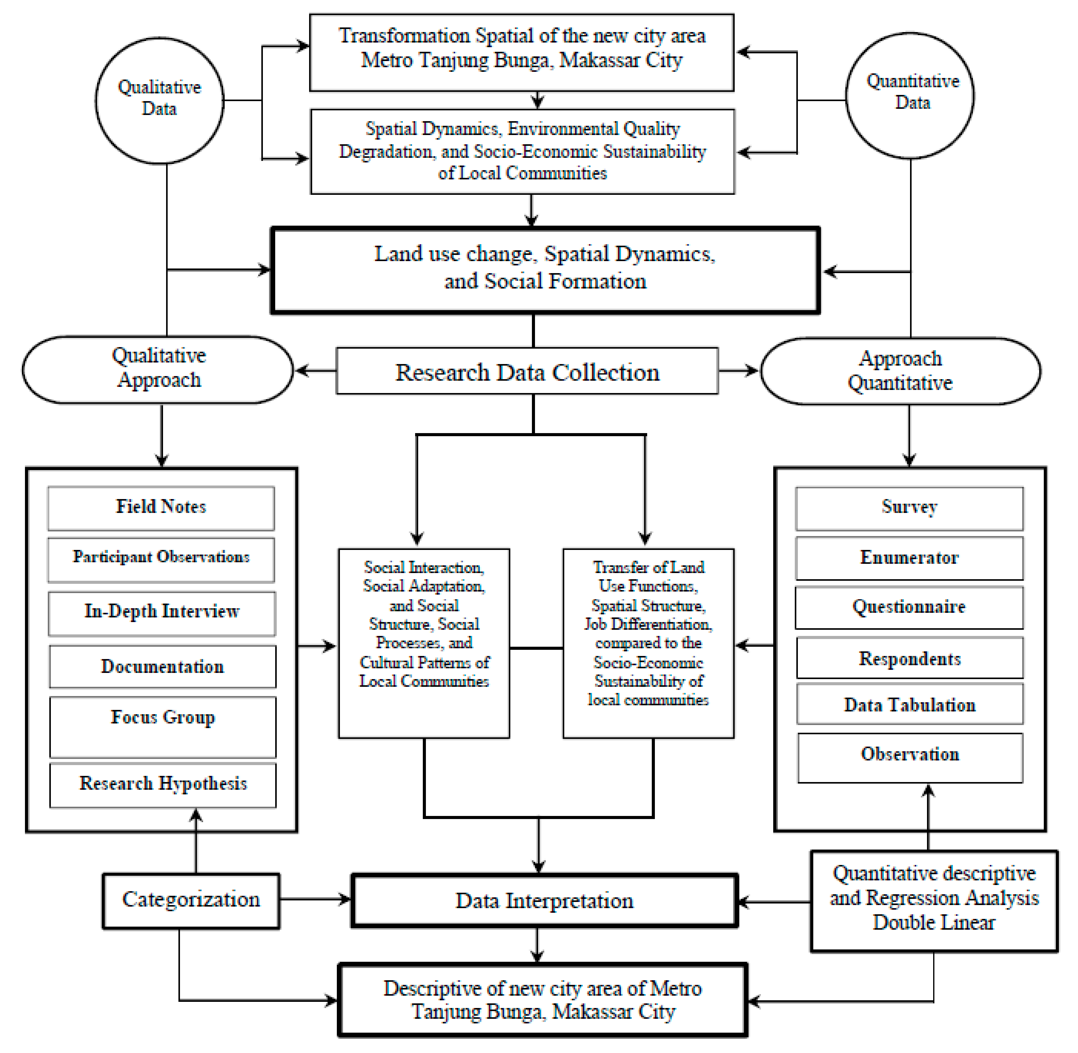
3. Research Methodology

3.1. Approach to the Case Study

The purpose of this study is to understand how spatial transformation, which was revolutionary for the development of the new city area of Metro Tanjung Bunga, has had an impact on changing the social formations of the local community, which was initially uniform, into multiple social formations. Furthermore, the social interactions and social adaptation between migrants and local communities cause changes in the social structure and cultural patterns of local communities. Thus, this study aims to analyze (i) spatial transformation works as determinants of changes in the social formation of local communities in the new city area of Metro Tanjung Bunga, (ii) the process of social interaction and social adaptation in these new social formations and the consequences of changes in the social structures, social processes, and cultural patterns of local communities, and (iii) the effect of changes in spatial use, social formation, and work differentiation on the socio-economic sustainability of local communities. A case study approach was chosen for several reasons: (a) Spatial physical changes in the new city area of Metro Tanjung Bunga are specific and revolutionary and are complexly arranged; (b) the case characteristics have prominent patterns, levels of consistency, and sequences; (c) the context of the new city area of Metro Tanjung Bunga is quite complex; and (d) the nature of this case is intended to explore a setting or moment of change in social formation due to spatial transformation.

3.2. Research Stages
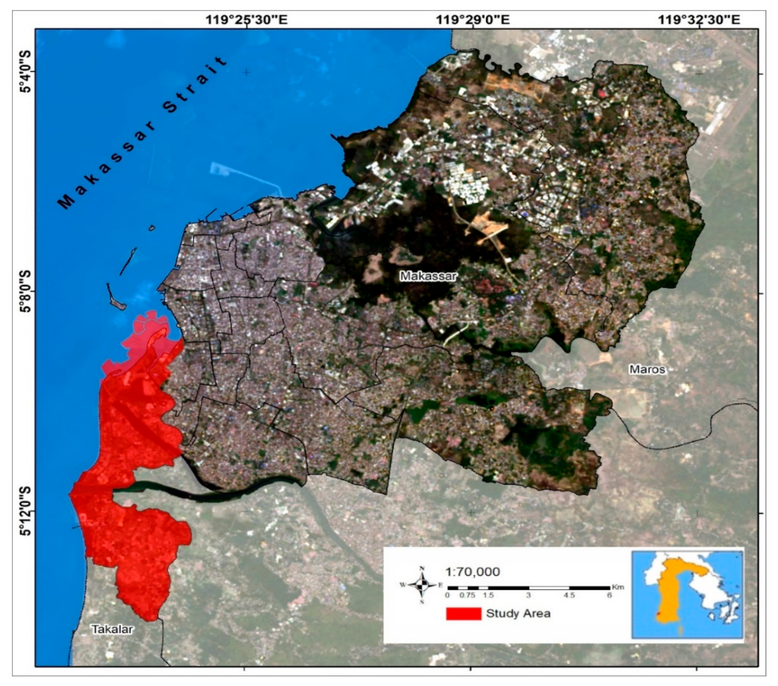
This study was carried out through three stages: First, the pre-field stage, including; (a) research design, (b) literature review, (c) research field selection, (d) research instrument selection, (e) data collection design, (f) data analysis procedure design, and (g) data validity assessment design. Next was the stage of fieldwork. In this process, we determined the background of the previous study—namely, the main factor causing changes in the social formation in local communities is spatial transformation associated with the transfer of land use functions and changes in spatial use. The developed assumption is that changes in social formation are caused by changes in the mode of production due to the transfer of land use functions and the existence of the functions of socioeconomic activities in the new city area of Metro Tanjung Bunga. The third stage was entering the field. In this process, we explored and determined the situation, as well as studied the circumstances and backgrounds of the local communities and migrant populations to improve our relationship with the subjects under study. Fourth, we participated while collecting data. In this process, several steps were carried out, including (i) limiting ourselves to the entire scope of the research, (ii) recording data using field notes, (iii) recording data using tools such as audio recording devices and video recorders if the subject did not object, (iv) examining settings in which there were conflicts, and (v) conducting an analysis in the field to explore the concepts that will be elaborated according to the research objectives.

3.3. Study Area

The location of this research was the new city area Metro Tanjung Bunga, which has different specifications from other suburbs in Makassar City in terms of its spatial use and in current development intensity and is in direct contact with changes in the local community. The new city area of Metro Tanjung Bunga was originally dominated by rural agrarian communities, even though it was administratively included in the Makasssar City. The results of the initial identification indicated that the new city area of Metro Tanjung Bunga is a suburban area experiencing rapid development of its physical, social, economic, and cultural elements. Furthermore, the spatial structures and spatial patterns in the new city area of Metro Tanjung Bunga underwent a very significant change due to the development of several new activities—namely, trade and shopping centers, large-scale settlements, education, tourism, and transportation. The consequence of these changes were changes, in the social structure, social processes, and cultural patterns of local communities.
Local communities that still survive in the new city area of Metro Tanjung Bunga cannot avoid interacting with migrants and adapting to the new environment. Furthermore, the land tenure of local communities underwent significant changes, spatial transformations, and cultural diffusion. Change cannot be avoided by the local community in both the area’s symbols and its shared identity. Furthermore, the rapid development of Makassar City’s transportation system is positively associated with the changing patterns of interaction between the surrounding urban and rural areas. Moving between the center of Makassar City and the new city area of Metro Tanjung Bunga takes approximately 15–25 min. The area’s many choices of transportation modes can be used to ease the movement and mobilization of the population. The research location in Figure 2, and the geographical position of the new city area of Metro Tanjung Bunga is shown in Table 1.

3.4. Method of Collecting Data

The sources of data in this study were determined by the focus and purpose of the study. The data in this study were obtained through field observations, documents, surveys, and in-depth interviews. In qualitative research, a sample of data sources is chosen while prioritizing the emic perspective. That is, prioritizing the views of the informants and how local communities located in the new city area of Metro Tanjung Bunga experience changes in social formation due to spatial transformations by examining and interpreting their environments based on their own foundations. Furthermore, in accordance with the focus of the study, the data sources in this study include (1) spatial transformation data as a determinant of changes in social formation, whose data sources are the intensity of land use, spatial patterns, spatial structure, and development zones of the new city area of Metro Tanjung Bunga obtained through field observations and documents; (2) data on the social interactions and social adaptations between migrants and local communities in the new social formation. The sources of these data were the local communities and migrants, and the data were obtained through surveys and in-depth interviews; (3) data on the consequences of changes in new social formations on social structures, social processes, and cultural patterns. The source of the data was the local community, supported by other data sources on the development of the new city area Metro Tanjung Bunga through observations, documents, surveys, and in-depth interviews; and (4) data on the effects of changes in spatial use, social formation, job differentiation, environmental degradation, and the socio-economic sustainability of local communities, which were obtained through detailed surveys and observable behaviors.

3.4.1. Research Instruments

In this study dominantly used a qualitative approach. Thus, the research instrument is the researcher himself. Next, the initial action taken was to validate the data. The qualitative approach used is a human instrument, which functions to determine the focus of research, select key informants as data sources, especially for local communities who in the new city area of Metro Tanjung Bunga and experience first-hand the process of change, due to a very fast and revolutionary spatial transformation. Thus, the researcher acts in the process of collecting data, assessing data quality, interpreting data, and making conclusions [50,51].
The steps we took included the following: (1) Increasing sensitivity through interactions with any stimulus from the environment that was predicted to be meaningful in this study. This means that we interpreted the spatial transformation of work as a determinant of changes in social formation in the new city area of Metro Tanjung Bunga. The instruments in this study were used for several purposes, including the following: (1) The researcher as the main instrument: This process was carried out by adjusting to all aspects of the situation for the purpose of data collection; (2) the researchers involved themselves in the process of interaction for the purpose of understanding, feeling, and exploring how social interactions and social adaptations are experienced by local communities by referring to the relevant theories; (3) drawing conclusions based on the data collected for use, obtaining confirmation, and changing/improving the data as needed; (4) trustworthiness was enhanced by responding to the social phenomena that occur, especially those related to the phenomenon of spatial transformation as a determinant of changes in social formation.
The quantitative instrument in this study was a questionnaire. This questionnaire was used to measure the intensity of patterns of the social relations, social interactions, social adaptations, job differentiation, and socio-economic sustainability of local communities that are associated with educational backgrounds and income levels due to the specialization of local community activities and changes in modes of production, as well as their relationship with the spatial transformation of the new city area of Metro Tanjung Bunga. The questionnaire was distributed to nine sub-districts which are the new city area of Metro Tanjung Bunga which is still inhabited by local communities. The reason the researchers determined the location was based on the significant development conditions of the new city area Metro Tanjung Bunga and a very intensive land use change. Furthermore, the criteria for the perpetrators who filled out the questionnaire (respondents) were local communities and immigrants, already married, at least living permanently or not leaving the place for a period of 5 years.

3.4.2. Triangulation

Triangulation is a data collection technique that combines data from different sources from the same source. This research was carried out by combining observations, in-depth interviews, and documentation for data sources simultaneously to test the credibility of the data and interpret spatial physical changes as a determinant of changes in the social formation of local communities in the new area of Metro Tanjung Bunga. In this way, the data that were consistent, thorough, and certain within the framework of achieving the research objectives. Data were collected through observations and in-depth interviews and structured.
The primary data were obtained directly by the researchers from the field through surveys, in-depth interviews, and observations. Data acquired through surveys and researchers were categorized as quantitative data, while the data acquired from in-depth interviews and observations were categorized as qualitative data. The primary data collected through this technique were quantitative data collected through the survey, including (i) the spatial physical condition of the new city area of Metro Tanjung Bunga; (ii) the status of the land occupied by the local communities, (iii) the frequency of patterns of social relations, social interactions, and social adaptation between migrants and local communities; (iv) land tenure status; and (v) the division of labor and the roles of institutions in community groups. Thus, the hypothesis developed in this study is that there is a relationship between changes in space use, changes in social formation, and job differentiation on the socio-economic sustainability of the local community in the new city area of Metro Tanjung Bunga.
Qualitative data collected through in-depth interviews included (a) the social stratification of local communities and migrants, (b) the systems and mechanisms of work among local communities and migrants, (c) the dominant economic activities of local and migrant communities, (d) the relationship and social control patterns, and (e) the factors that lead to survival and changing patterns of social relations. The qualitative data collected through observations include (a) the land use functions before and after development of the new city area Metro Tanjung Bunga, (b) residential facilities for local community groups, (c) social stratification and social status, (d) patterns of social interaction and social adaptation, and (e) work systems and community group institutions.

3.4.3. Research Informants and Respondents

Informants in this study were used for qualitative data collection. Determination of the informants was done by the snowball method, meaning that the researcher determined the person who could be interviewed based on the information provided by the local community—in this case, the local community was able to provide good information about the development of the new city area of Metro Tanjung Bunga. Next, the informants were selected from among several respondents who had been interviewed before. This step was intended to further explore some of the questions that were answered in the questionnaire but required a more detailed explanation. This informant was considered “the perpetrator” in the phenomenon under investigation.
The number of informants was 15—5 from outside the respondents and 10 from the respondents. The selection of the 5 informants from outside the respondents was based on information obtained at the village office. Furthermore, the informants were sourced from among the respondents with the following considerations: (1) Experiencing a case in their family regarding land sales; (2) mastering a fairly large area of land before the new city area of Metro Tanjung Bunga was built; (3) using their land for the development of socio-economic activities by developer; (4) having familial relationships that maintain a form of mutualism and commensalism symbiosis; (5) being able to provide good information about the environment in which they live; (6) being able to provide good information about the patterns of the social relations, social interactions, and social adaptations of local communities with migrants.
Quantitative data were collected from the respondents or research samples. The sample was determined using the stratified random sampling method. Sampling was based on dividing the population into strata selecting simple random samples from each, strata and combining those samples into a single sample to estimate the population parameters. The stratified random sampling method is a method for selecting samples by dividing populations into homogeneous groups called strata. Then, the samples are taken randomly from each of these strata [50,51]. This method is used with the consideration that the study population is not homogeneous or proportionally distributed. In this case, local communities and migrants were distinguished based on their educational backgrounds and income levels. The results of the questionnaire were analyzed using the multiple regression method and percentage analysis based on frequency numbers. Sampling based on Isaac and Michael [52]. The formulations used are as follows:
s = λ 2 N PQ d 2 N 1 + λ 2 PQ
where s is the number of samples, N is the population number, and λ2 is a chi-square (with dk = 1, error level 1%, 5%, and 10% d = 0.05; P = Q = 0.5). Furthermore, the number of samples in this study was set at 350 samples.

3.5. Data Analysis Method

Data analysis, in this study, was used to develop the research concepts. This process involved (i) organizing data based on the data that were collected (e.g., field notes and researcher comments, pictures, photos, and documents in the form of reports). Data analysis involved organizing, sorting, grouping, coding, and categorizing. This organization was carried to find themes for use as substantive theories. For the case studies in the new city area of Metro Tanjung Bunga, we relied more strongly on qualitative research as an assessment tool for the data collected through the questionnaires. Furthermore, in-depth interviews were conducted with informants for the purpose of comparing respondents’ answers and asking for detailed explanations for both respondents and outside respondents who had been previously interviewed. The aim was to determine the intensity of local community relations, their relationships to social ties, and the principles of values and norms that are still adhered to in the community. The researcher asked the informant to provide a detailed explanation of the frequency of patterns of social relations and social ties between individuals in a group, both those that occurred before the construction activities and those after the construction of the new city area of Metro Tanjung Bunga.
Quantitative research was used to explore information through several questions that were compiled and given alternative answers. The questions compiled by the researchers in the questionnaire were based on the results of preliminary observations made in the field. That is, we sought information related to the social interactions and social adaptations between migrants and local communities. Furthermore, traditions and practices are still being engaged in to maintain the existence and sustainability of local communities. The local communities selected as respondents were those who were categorized as perpetrators of kinship within the community group.
Data analysis was carried out in the field at the time of data collection, to separate information into categories, transforms the information into a narrative, and present the writing qualitatively. The questionnaire itself was used to analyze the effects of the transfer of land use functions, spatial use, spatial structure, changes in social formation, job differentiation, and environmental degradation on the socio-economic sustainability of local communities. The first stage conducted was data collected from the results of the interviews and observations. Secondary data were then analyzed using an emic and ethical approach. Furthermore, data on the patterns of social relations and social interactions based on the results of the interviews with informants were strengthened by observations conducted at the research location.
The emic approach in this study related to the conclusions drawn from spatial transformation as a determinant of changes in the social formation of local communities in relation to the transfer of land use functions and changes in spatial use based on the informant’s perspective. Furthermore, the data were considered ethical data when we determined the informant’s views on the phenomenon of the development of the new city area of Metro Tanjung Bunga. Emic and ethical data were used by gathering information from the informants and respondents as the main data of the study. Thus, data analysis in a qualitative approach starts from data collection in the field and is then grouped according to the focus of the study.
The data that were grouped were then used for the interpretation or verification of data based on the theory used as a reference in this research. The process of interpreting or verifying the data in question involved comparing the status of land ownership, land function, and land status prior to development in relation to the spatial structure, spatial function, and space utilization after the construction of the new city area Metro Tanjung Bunga. Furthermore, we collected data on the location of residence, type of work, social interactions, and patterns of social relations, social stratification, social status, social structure, and cultural patterns of the local community to be interpreted for the dynamic process of the development of the new city area of Metro Tanjung Bunga. This activity involved analyzing qualitative research that was collected into additional information or research data. These data were then analyzed by studying their tables and how frequently they inform changes in the patterns of social relations and changes in social structures and cultural patterns of local communities.
Data analysis was done by combining qualitative and quantitative data. The steps used for the qualitative research were simultaneously used for the quantitative research. At the time of interpretation or analysis, each data was reduced, namely categorization for qualitative data and regression analysis for quantitative data using descriptive statistics. Furthermore, the two data were interpreted via triangulation or between methods techniques. That is, the data obtained from the questionnaire were explored again through two methods (qualitative and quantitative). This merger was done to strengthen the validity of the analysis results.
Data reduction involves the grouping or categorization of data according to the scope of the study. Likewise, with the questionnaire all questions posed referred to the main, focus of the study. Thus, a quantitative approach was used to explain some parts of this research, specifically the patterns of social relations and social interaction at the local community level in the new city area Metro Tanjung Bunga. The analysis was carried out during data collection and after data collection was completed. At the time of the interview, the researcher conducted an analysis of the answers being assessed to obtain credible data. The analysis was carried out interactively and thoroughly. The activities in data analysis included data reduction, data presentation, and the development of conclusions.
Data reduction was carried out with the following considerations: (1) The data obtained in the field were numerous and complex, so data reduction was immediately carried out by grouping similar data for interpretation; (2) we selected and summarized the main points, focused on important factors, and sought themes and patterns to formulate conclusions; (3) reduced data will provide a clearer picture of the topic and make it easier for researchers to collect further data in the framework of the data analysis; (4) data reduction will be coded by certain aspects according to the purpose of the study.
After the data were reduced, the next step was to present the data: (1) Quantitative data were presented in tables and graphs. The aim of this process was to organize data, arranged in relationship patterns, to facilitate the analysis; (2) the presentation of qualitative data was done via brief descriptions, charts, and the relationships between the categories and relevant theories applied; (3) the data were presented in a text-based and narrative form to facilitate understanding; and (4) the data display used letters and numbers arranged sequentially to understand the structure. Then, an in-depth analysis was conducted and adjusted based on the phenomenon being studied. Thus, this research was broad and then focused. The stages of data analysis were carried out by combining the qualitative and quantitative approaches of domain analysis, taxonomy, componential analysis, and cultural theme analysis.
Quantitative analysis in this study was used to address the effects of land use change, spatial use, spatial structure, changes in social formation, job differentiation, and environmental degradation on the socio-economic sustainability of local communities (changes in spatial use (X1), changes in social formation (X2), and job differentiation (X3) on the socio-economic sustainability of local communities (Y)). Each respondent for each question gave the answer with the highest score (score of five). The second step was done by dividing the results of the research scores with the ideal score. We tested the effects between variables using the multiple linear regression method with the following equation:
Y = β0 + β1 X1 + β2 X2 + β3 X3 +…+ βn Xn + ε
where Y is the dependent variable, X1, X2, X3, … Xn are the independent variables, ε is the random residue, and β0, β1, β2, β3, … βn is a population parameter whose value is not known and must be estimated from the data. The β1 value indicates the contribution of the independent variable X1 to the dependent variable Y. The process of combining qualitative and quantitative research in this study is illustrated in Figure 3.

4. Results

The spatial transformation in the new city area of the Metro Tanjung Bunga area is related to land use changes, and the conversion of productive agricultural land is influenced by two factors: (a) Centrifugal spatial development and (b) centripetal spatial development. The process of spatial development horizontally determines the increasing area of urban spaces and increasingly densely developed building areas. Meanwhile, larger cities are forced to expand their administrative boundaries, thereby seeking to manage the unrestrained urban development along the horizontal axis, which has become the largest urban threat of the 21st century [53]. Multi-scale indicators from building permit records provide useful insight into the diachronic mechanisms of urban growth, with implications for regional planning and the design of sustainable development practices [54]. Furthermore, rapid economic development, population growth, and increasing industrialization have led to faster and more substantial urban expansion, which has had an impact on the historical environment of rural areas [55].
Centrifugal spatial development can be formulated as a process of adding space that occurs horizontally by occupying spaces that are still empty. Furthermore, the polarization of Makassar City space’s function in the new city area of Metro Tanjung Bunga area is marked by the existence of several functions of urban activities, namely large-scale settlements, trade and shopping centers, tourism, educational facilities, health facilities, offices, services, and transportation systems. The relevant plans promoted land use diversity and the incorporation of service facilities to support business functions [56]. The existence of this function is driving the influx of migrants into the new city area of Metro Tanjung Bunga to transform the uniform social formation of the local community into a dual social formation. Urbanization is phenomena where the excessive complexity and dimensions of problems should not hamper action; instead, actions should be encouraged and facilitated with synergistic and integrative pathways for sustainable urban development [57].
Spatial transformation is closely related to changes in land use in the new city area of Metro Tanjung Bunga. This development mainly takes place in peri-urban areas due to the high pressure caused by the growing population and the lack of facilities and infrastructure in the city centers [58]. The period 2003 to 2005 was characterized by the dominant use of agricultural land and aquaculture as the main orientation of the local community. The new city area of Metro Tanjung Bunga is located in the Makassar Strait coastal area. Observations show that in this new city area of Metro Tanjung Bunga has experienced land expansion with an average of 50 m per year. The expansion of land area (to the end of 2019) reached 1500 m from the coastline. Furthermore, the entry lane from Makassar City to the new city area Metro Tanjung Bunga at that time was connected via a pioneering road from the Nuri direction along the banks of the river Jenneberang. The experience of developed countries today is mainly the result of rural to urban migration due to the industrial revolution, while developing countries have, in recent times, been driven by an increase in natural urban populations [59].
The new city area of Metro Tanjung Bunga was initially an undeveloped area and predominantly a productive agricultural area with fishponds. The community is predominantly engaged in the agricultural sector (rural agrarian), although the area is administratively included in the Makassar City area. Rural development in the new urban areas can be divided into the following five types: The ecological leisure type, the traditional farming type, the balanced development type, the industrial-and-agricultural mixed type, and the industrial promotion type [60]. The period from 2006 to 2010 was marked by the intensive conversion of agricultural land, changes in spatial use, and changes in the land ownership status of local communities towards developer ownership. These conditions had an impact on reducing the area of productive agricultural land and aquaculture based on the functions of urban activities. Furthermore, the ongoing processes of rapid economic growth and urbanization not only bring great opportunities but also new challenges to agriculture and rural society [61]. Furthermore, the special situation of shrinking cities will ideally allow those cities to pursue measures to transition towards sustainability, which may be harder to accomplish in growing cities [62].

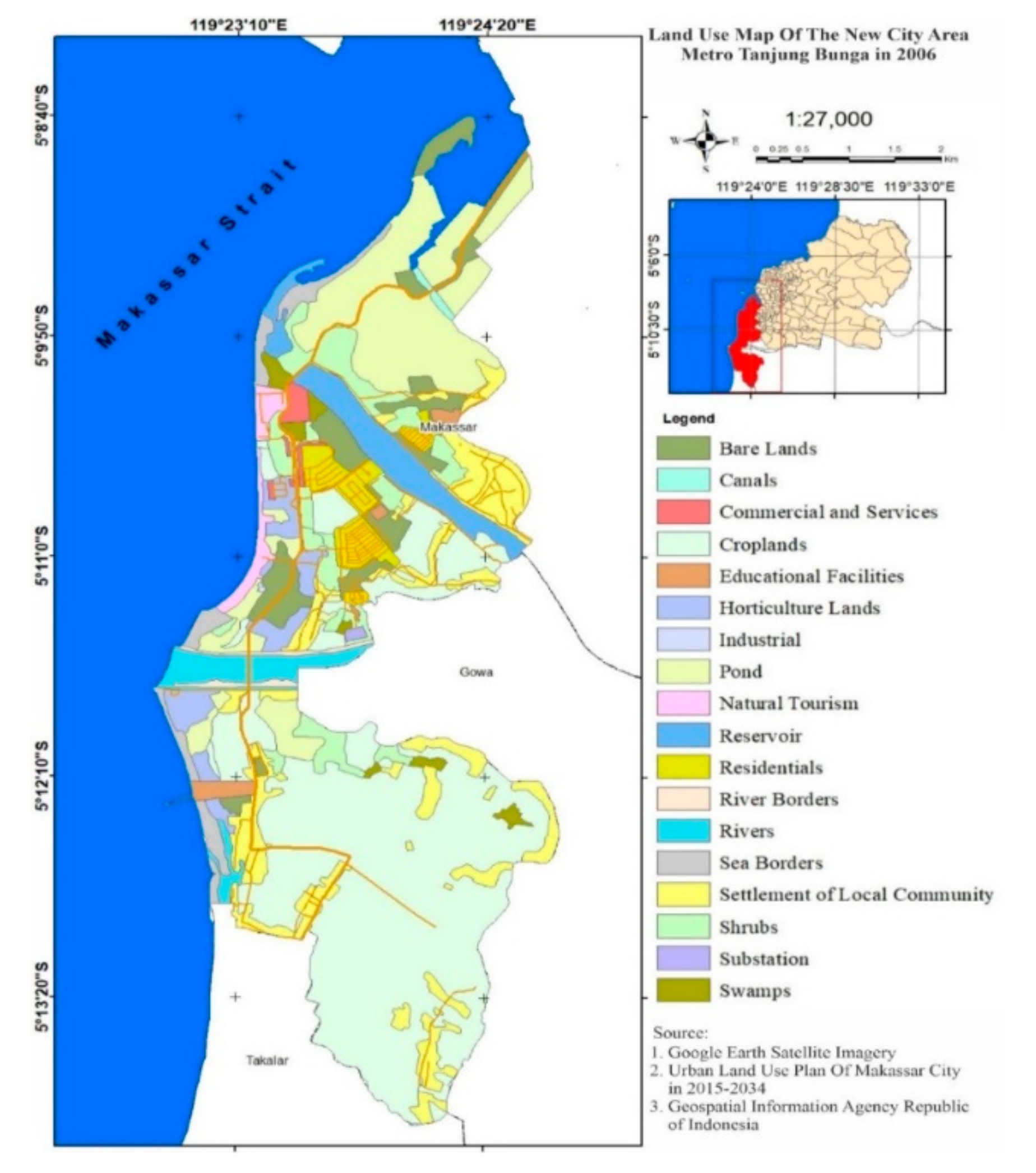
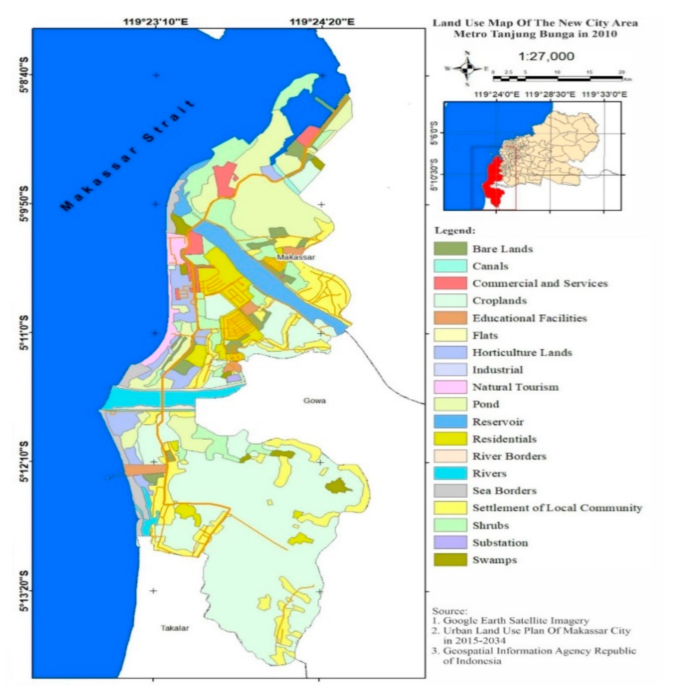
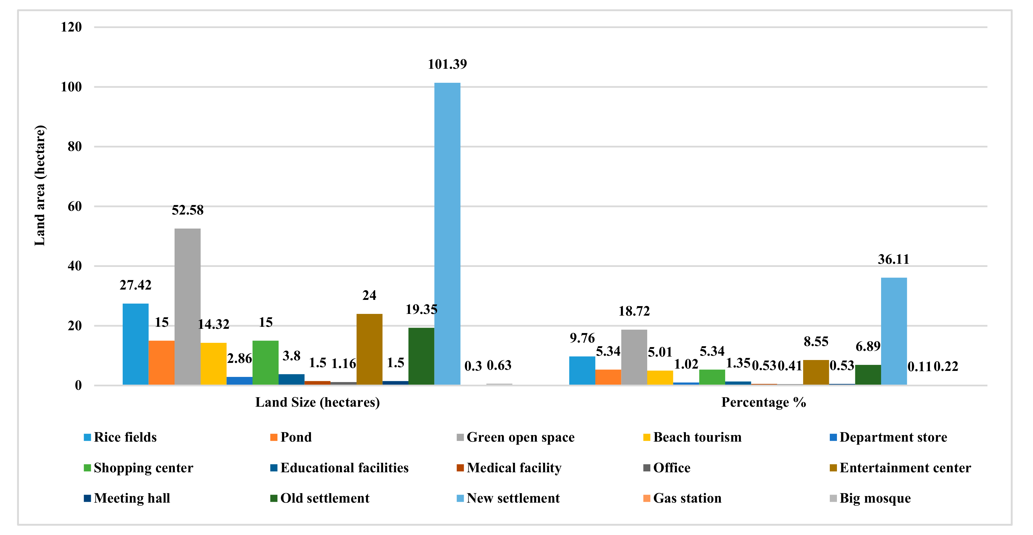
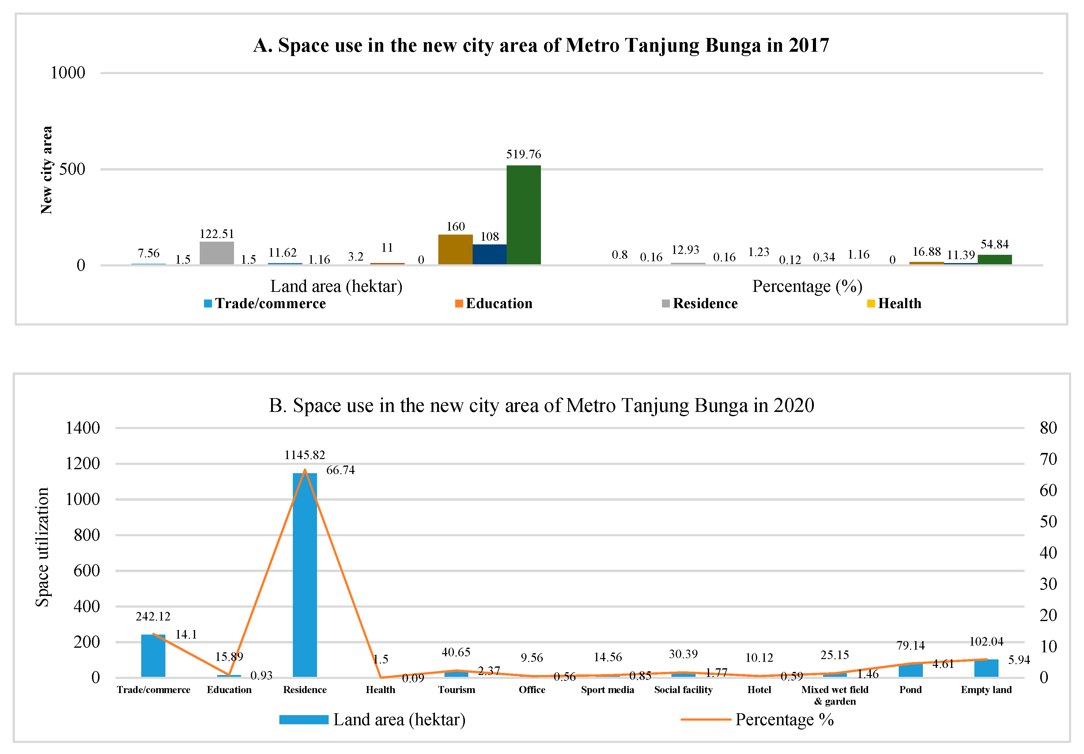
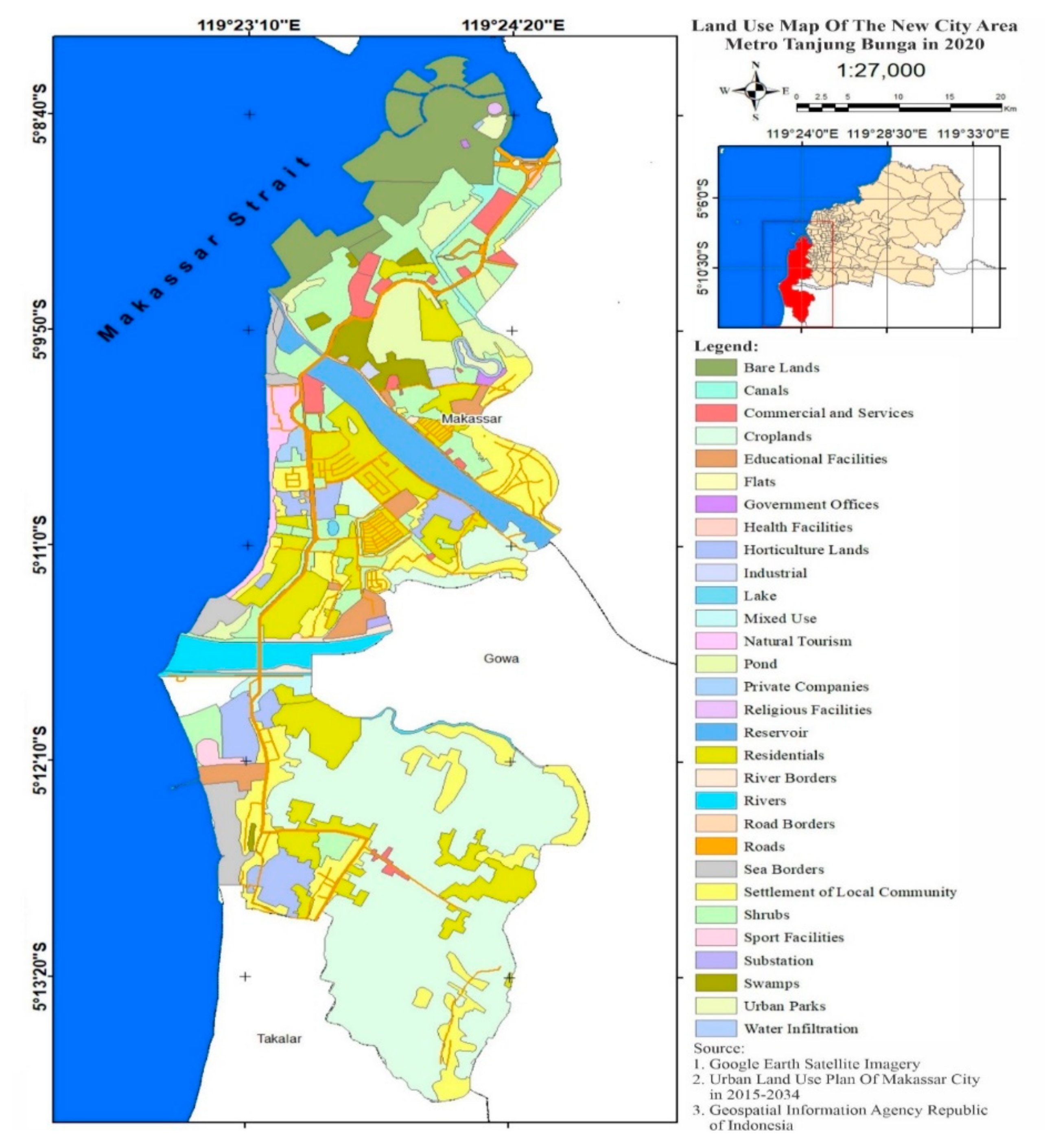
4.1. Determining Spatial Transformations in the New City Area

2006–2007 was the initial period when local communities transformed from an agrarian society into an urban industrial society. This development was marked by a reduction in the productive agricultural land from an initial condition of 889.14 hectares to 27.42 hectares, in pond land from an initial condition of 108.40 hectares to 93.40 hectares, in mixed gardens from an initial condition of 11.20 hectares to 5 hectares, and in vacant land from an initial condition of 160 hectares to 85.32 hectares. One of the most compelling issues in the transition from an agrarian to industrial society is the role played by urban development in the creation of industrial modernity [12]. Therefore, land use and city planners will increasingly have to address the costs of occupying productive agricultural land and the conversion of natural habitats [63]. Furthermore, the expansion of urban land intensifies conflicts between urban space, agricultural space, and ecological space [64].
The spaces that experienced significant changes in the new city area of Metro Tanjung Bunga include (1) settlements, from an initial condition of 19.35 hectares to 101.39 hectares; (2) socio-economic facilities, from initial conditions of 5.75 hectares to 17.00 hectares; and (3) recreational activities, from an area of 4 hectares to 18.32 hectares. Furthermore, to support the development of the new city area of Metro Tanjung Bunga, the developer has prepared an area of 519.76 hectares as a new development area. Thus, a decrease in agricultural land use intensity indicates greater future farmland expansion at the expense of other ecosystems [65]. Furthermore, the spatial structure and configuration of land-use patches, i.e., landscape patterns can affect the flow of energy and materials in inner-urban ecosystems and hence the sustainable development of urban areas [66]. These conditions indicate that the spatial transformation of the new city area of Metro Tanjung Bunga has experienced a rapid and revolutionary acceleration. Furthermore, the existence of new socio-economic activities is an attractive factor for the infiltrative and expansive influx of migrants. Ultimately, the economic effects of migration have an impact on job creation, additional income, poverty risk reduction, improved education, and living standards [67].
The acceleration of the development of the new city area of Metro Tanjung Bunga is closely related to the centrifugal spatial development of Makassar City towards the periphery and reflects variations in the intensity of spatial use. Rapid urban expansion often has a violent impact on the regional landscape, mainly due to the conversion of a large amount of agricultural land into construction land and other urban land types [68]. Six factors that drive the centrifugal process for the new city area of Metro Tanjung Bunga are (a) accessibility; (b) public services; (c) land characteristics; (d) characteristics of landowners; (e) the existence of regulations governing land use; and (f) developer initiatives. These six factors are positively associated with changes in spatial use, social formation, and ecosystem complexity. These conditions have an impact on social differentiation related to economic income, social status, lifestyle, consumption patterns, and living conditions, and highlight the differentiation and combination of social groups in geographical space [69].
The field data show that land that was initially low in economic value with a value of $25 per square meter then experienced a fairly high increase to a value of $100 per square meter after being developed by the developer for several functions of urban activities, including (1) shopping center construction; (2) elite settlements equipped with adequate, complete, and modern infrastructure and facilities; and (3) the preparation of mature land plots. These three factors are determinants of spatial transformation to facilitate the functions of commercial activities, large-scale settlements, and changes in the social formation of local communities. Rapid economic and social development is exerting sustained pressure on land demands [70]. The landscape is a very dynamic system with natural and social interconnected systems that are strongly affected by constant change [66]. Furthermore, these changes are subject to various influences (e.g., socio-economic, political, and environmental). In addition, urbanization has also had a great influence. This is typified by the conversion of productive agricultural land and semi-natural ecosystems into built-up areas accompanied by the negative ecological impacts of habitat deterioration and fragmentation [71]. Thus, it can be concluded that the development of new urban areas causes changes in social formation, social structure, and lifestyle based on the complexity of urban ecosystems.
The dynamics of the fast and revolutionary development of the new city area of Metro Tanjung Bunga have two symptoms with a significant effect: (1) The existence of a dominant developer focused on profit maximization, such that any idea will be accepted as long as it is able to bring the expected financial benefits; (2) the results of Makassar City spatial planning are more focused on the benefits of the region and the community, so the formulated spatial planning policies are more oriented towards the welfare of the population. Both, of these experiences collide and are very difficult to reconcile. This condition is also triggered by the licensing practices, which indicate that many violations occur. As a result, the spatial concept is applicable theoretically but becomes meaningless in the field. Thus, understanding the response mechanisms of ecosystem services to land-use changes is critical for developing systematic and sound land planning [72]. Furthermore, the weak control of spatial use and licensing expenditure practices make it much easier for development to have an impact on land use changes and environmental degradation.
A high intensity of land use change has caused transformations in spatial patterns and reductions in the areas of agriculture and aquaculture. This condition is marked by the high sale and purchase transactions of land between local communities and developers. Since 2006–2008, agriculture and fish-based activities are no longer the main sources of livelihood for the local communities. Changes in the livelihood orientations of local communities are strongly dependent on the spatial transformations that take place very quickly and are revolutionary. The local community activities and use of space in the new city area of Metro Tanjung Bunga are shown in Figure 4 and Figure 5 below.
Figure 4 and Figure 5 show the spatial use of the new city area of Metro Tanjung Bunga, Makassar City. Interpretations that can be proposed related to the use of the space include (i) the orientation of the main activities of the dominant local community in the agricultural sector; (ii) the patterns of population activity, which are still characterized by kinship and patronage relations; (iii) the community characteristics, which are still homogeneous; and (iv) the dominant patterns of developing settlements, which feature agricultural production activities. Furthermore, the acceleration of the development of the new city area of Metro Tanjung Bunga has an impact on the differentiation of the work of local communities.
Figure 6 shows that until 2006, the total population still carrying out agricultural activities comprised 2686 households. By 2008, there were 112 families, with a reduction of 2574 households. Furthermore, the livelihood orientations of local individuals as fishermen in 2006 totaled 621 households, and by 2008, this number totaled only 50 households, or a reduction of 571 households. This figure illustrates that the existing local communities have experienced significant changes in their livelihoods. Furthermore, differentiation affected the economic businesses that developed in 2008: (i) Laborers by 55.55%, (ii) construction workers 27.40%, (iii) mobile vegetable traders by 3.37%, and (iv) stall businesses by 0.67%. This fact illustrates that the orientation of the livelihoods of local communities has experienced a shift from the previous conditions. Three categories of livelihood orientation can be defined for the local communities after undergoing spatial transformation: (1) Relatively small amounts of agricultural activities, (2) increasing urban informal sector activities, and (3) formal sector activities, especially for those who have education and certain skills (i.e., engaging in commercial activities under the system of capitalism).
In the period of 2010–2013, the spatial transformation in the new city area of Metro Tanjung Bunga entered the second phase of development activities carried out by the developer. This condition is characterized by an infiltrative and expansive influx of migrants. The presence of the migrant population is positively associated with the social, economic, and cultural life of the local community. Furthermore, the spatial transformation that took place had an impact on the transition from a rural face to an urban face characterized by the complexity of spatial use. Preferences for urban and suburban locations reflect complex socioeconomic phenomena such as sprawl, class segregation, gentrification, and filtering [73]. The data from the field show that along the corridor of Metro Tanjung Bunga road from the center of Makassar City towards Barombong, services, shops, offices, settlements, and recreational facilities have developed. This condition is marked by the presence of new functions, including (a) the Celebes Convention Center, (b) Trans Studio, (c) Mall GTC, (d) office center, (e) Akkarena beach tourism, (f) shopping centers, and (g) elite housing.
Furthermore, in the new city area of Metro Tanjung Bunga has developed several locations featuring new residential complexes built by developers, namely (i) housing Menteng Garden, (ii) Nirwana park, (iii) Khayangan park, (iv) Losari park, (v) Pantai Biru villa, (vi) Taman Losari 2000, (vii) Danau Biru villa, (viii) Masamba garden, and (ix) Toraja park. The residential area built by the developer occupies an area of 101.40 hectares, with 1954 houses built by the end of 2013. The field data showed that the developing residential complexes were categorized as very luxurious to luxurious. These settlements are generally built with a permanent and sturdy fence, closed from all directions, with only one door for access. This type of home is also guarded by a portal officer who engages in a fairly, strict examination of guests who enter the complex. This highlights that the patterns of exclusive life for new communities of migrants in the new city area of Metro Tanjung Bunga, Makassar City. Conventional environmental typologies—planned, informal, and mixed types—are accompanied by complex challenges, an endless demand for affordable housing, transportation networks, basic services, and jobs [74,75].
The dynamics of the area’s development illustrate that the spatial practices taking place cause changes in the means of production towards the reproduction of space that is driven by capitalism. The acquired data show that this space developed by the developer is positively associated with the presence of capitalism. In many ways, the new city area of Metro Tanjung Bunga is reproduced by the mechanism of the capitalist system, thereby producing differences in the class structure of the economic system of the local community and its impact on changing social formation in the desired direction. In the history of capitalist societies, the ecological conditions of social reproduction have been largely ignored or downplayed. Only under the exacerbating ecological crises of recent decades have economists, policy makers, and the common public begun to pay more attention to the natural limits and conditions of sustainability [76]. Two types of spatial expressions occur due to this process: (a) Spatially linear (linear) physical development and (b) concentric spatial physical development. The spatial expressions that occur in the new city area of Metro Tanjung Bunga are each stand-alone and a combination of two kinds of expressions, making the spatial expressions more complex. The impact on the human dimension has a greater effect on the diversity of land uses, and the classification of real estate finances leads to the integration of walkability in the built environment [77].
Figure 7 shows the spatial expression of the new city area of Metro Tanjung Bunga, which has had an impact on urban differentiation by increasing the scale of modern urban industrial factors. Three factors underlie this process: (1) The distribution and range of activities related to the intensity of relations between urban areas are increasing; (2) functional differentiation; and (3) spatial organization complexity. The field data show that spatial transformation is positively associated with the socio-economic dynamics of society. Furthermore, based on the process of forming socially varying spaces in relation to spatial transformation, three phenomena emerge in the new city area of Metro Tanjung Bunga: (1) Changes in the range and intensity of commercial economic activities resulting in the creation of new economic arrangements that require certain types of expertise and skills for accessing work. This makes livelihoods and education an important index of social differentiation; (2) the differentiation of new functions that develop and are predicted to continue in the direction of social and economic choices. This condition allows for several alternative activity patterns besides traditional activities to develop as modern patterns of activity; (3) the increasingly complex social order is reflected by changes in population mobility, population composition, the separation of ethnic groups, and segmentation within local communities. Fluctuations in housing construction activities become more intense over time, triggering real estate market segmentation, and making the construction industry’s performance even more unpredictable [78].
The impact of spatial transformation on the new city area of Metro Tanjung Bunga is moving towards changes in social formation from the working systems of traditional agrarian societies towards those of urban industrial societies. Changes in social formation are marked by the characteristics of social life based on the properties that are considered traditional or primitive compared to the characteristics of modern lifestyles. While cities atop the global hierarchy of the world’s urban spaces attract wealth, glamour, and prestige, they are also socially polarized to a greater degree than other cities and disproportionately attract migrants [79]. These changes have a tendency, to increase in scale to yield changes in the scale of the lifestyle of local communities. Three types of spatial expressions that can be constructed are related to lifestyle changes in the new city area of Metro Tanjung Bunga: (i) Social levels, (b) urbanization, and (3) segregation. Thus, a consolidated urban–rural land market and a better land market mechanism must be established, the supply of public goods and services for villagers must be increased further, and the monitoring and evaluation mechanisms must be further strengthened [80].
Furthermore, prolonged spatial physical development is positively associated with the expansion of the new city area Metro Tanjung Bunga towards the addition of urban areas. The field data show that a developed area is located along Metro Tanjung Bunga road, which extends towards Gowa Regency and Takalar Regency. This longitudinal pathway has controlled the growth of settlements and non-residential buildings in such a way that it forms a concentration of buildings with a spatial distribution far greater than its widening distribution. Space–time urban geography theory and empirical studies have confirmed that the range, scope, vigor, and attention of people’s daily lives are limited [81]. Thus, urban material and spiritual civilization continues to extend, to surrounding rural areas during this process and produce new spatial patterns and landscapes along with continuous changes in the regional industrial structure [82].
The pattern of developing settlements has a tendency towards the construction of large-scale housing complexes whose uniform shapes, sizes, architectural styles, quality, and prices will directly filter the entry of migrants. This means that those who do not have sufficient financial capacity will find it difficult to have a residential facility built by the developer. This factor has an impact on the separation of settlement facilities between immigrant residents and local communities in the new city area of Metro Tanjung Bunga. Three factors are foundational to justify these processes: (i) The ownership of housing is based on income, (ii) the ownership of housing is based on socio-economic class, and (iii) the selection and ownership of housing location is based on ethnic group (migrant or local). These three factors produce variations in the social space in the new city area of Metro Tanjung Bunga, which is developing in the direction of spatial separation and segmentation between migrants and local communities.
The field data show that the spatial zone developing in the new city area of Metro Tanjung Bunga is divided into three categories: (1) The main zone of the area, which is inhabited by residents with high socioeconomic status who are associated with high-income communities, complete social services, and the center of activities (e.g., shopping centers and other social activities). Those who inhabit this zone are dominant migrants consisting of powerful, professional, and business elite groups; (2) the zone between zone one and zone three is a location inhabited by groups of workers comprising migrants who enter and blend with the local community consisting of employees who work in businesses related to formal economic activities and have a much better income than those in in zone three; (3) the outermost zone (zone three) is inhabited by local communities with low socioeconomic status. The dwellings of this group are generally, houses on stilts and are very simple and tend to develop towards slum areas. The early urbanization process and the rapid development of the metropolis has various impacts on the interactive development of spatial zoning and the urban climate [83]. The utilization of space in the new city area of Metro Tanjung Bunga in the period of 2010–2013 is shown in Figure 8 below.
Figure 8 shows the acceleration of development in the new city area of Metro Tanjung Bunga in changing the use of highly complex spaces. The results of the field confirmation show that there are three factors that have changed in terms of spatial patterns that can be explained for the period 2010–2013: (1) Changes in the form of land use, especially in the center of the new city area of Metro Tanjung Bunga; (2) changes in the orientation of local community livelihoods; and (3) changes in the social fabric of local communities. These three factors demonstrate the changes of the local community’s social formation into multiple social formations. The utilization of space in the new city area of Metro Tanjung Bunga in the period 2010–2013 is presented in Figure 9 below.
Figure 9 shows how the new city area of Metro Tanjung Bunga is experiencing changes in the spatial use complexity of its urban ecosystem. Four significant factors are determinants of changes in spatial use and contribute directly to changes in the shape and typology of new urban areas, including (1) the housing development of an area of 19.35 hectares, which experienced an increase of 101.39 hectares or 36.11% of the total land use; (2) the preparation of 52.58 hectares or 18.72% of green open space; (3) the development of entertainment facilities covering 24 hectares or 8.55%; and (4) the development of shopping centers covering an area of 15 hectares or 5.35%. These four spatial functions, in addition to impacting changes in shape and typology, also contribute positively to the improvement of the transportation system from Makassar City to the new city area of Metro Tanjung Bunga through integration of the Metropolitan Mamminasata urban system. This condition is marked by the unification of the urban area of Makassar City with the regions of the Gowa Regency and the Takalar Regency in their physical, economic, and social-spatial interactions. Cities pose environmental challenges but also offer possibilities to close material and energy loops and connect multiple societal and ecologic services [84]. Furthermore, spatial interactions among city clusters are one of the main drivers of urban growth; the local government is not only an implementer of the development agenda but also a policymaker that defines rules on how to connect global goals with the local community [85,86].
Furthermore, the continued development of large-scale settlements has had a significant impact on the decrease in the production and productivity of agricultural land and the deterioration in the quality of the environment and its effects on surrounding rural conditions. A high intensity of agricultural land conversion is a triggering factor for changing the livelihood orientation and work of local communities from subsistence farming towards urban industrial work. Farmland abandonment is considered to be an important phenomenon for changing the eco-environmental and sociocultural landscapes of rural landscape, and emigration has become a key livelihood strategy for an increasing number of rural households, which in turn has a profound effect on land management [87,88].
The field data show that the process of forming the spatial structure of the new city area of Metro Tanjung Bunga is a capitalistic economic model oriented toward the highest profit value, beginning with the presence of a “capitalist economy”. This condition is based on the functional relationships of urban socioeconomic activities. That is, the built social division and spatial system is a product of the “capitalist mode of production”. A very prominent activity was marked by the presence of a shopping center (Mall GTC), which is the largest wholesale center in Eastern Indonesia, in addition to the presence of the Theme Park Trans Studio entertainment center, which is an international-scale entertainment facility.
The data found in the field show that the allocation of land to individuals in the new city area of Metro Tanjung Bunga is based on income relative to site selection and residential references. Furthermore, land ownership will determine the amount of rent, which will create a certain land use structure. Thus, the spatial transformation in the development of the new city area of Metro Tanjung Bunga Makassar was found to be a symptom of the dominance of the use of existing land based entirely on the strength of capital and wealth. Furthermore, land tenure is largely determined by the financial capacity of individuals and institutions due to the variations in land rent, which tends to increase. Thus, the closer the service centers are, the higher the land value will be, and vice versa. Land and people are the foundations of every nation, while in urban areas, rapid economic and social development is exerting sustained pressure on land demands, and land development is essential for economic growth and the advancement of urbanization [89,90]. This condition illustrates that the existence of local communities that inhabit new urban areas will make it very difficult to engage in economic business competition, including competition for the ownership of production facilities. Thus, spatial transformation repositioned local communities as marginal groups even though they still chose to live in the new city area of Metro Tanjung Bunga.
The results of the field confirmation give an overview of the relevant mechanisms of relations and the modes of production, showing that the arrival of capitalism has transformed traditional agriculture-based spaces into a more modern economic system. Furthermore, the owners of existing real estate and trade industries, in this case called “capitalists”, will always direct and control workers and their production. The relationship between the ruling class and the ruling dynamics in the development of the new city area of Metro Tanjung Bunga is positively associated with the division of classes, and social friction is a stimulus that causes a transformation of the uniform social formation of the local community into multiple social formations. Changes in the spatial use of the new city area of Metro Tanjung Bunga in 2017–2020 are shown in Figure 10 and Figure 11 below.
Figure 10A,B and Figure 11 show the very rapid and revolutionary spatial dynamics of the new Metro Tanjung Bunga city area. The intensity of spatial use in 2017 is the third phase of the development of the new city area of Metro Tanjung Bunga. The transfer of land use functions that tend to increase is characterized by significant changes in spatial patterns. The spaces that tend to increase at this stage include (1) housing that utilizes an area of 122.51 hectares or 12.93%; (2) tourism facilities utilizing an area of 11.62 hectares or 1.23%; (3) social facilities utilizing 11 hectares of land or 1.16%; and (4) trade and shopping centers utilizing 7.56 hectares of land or 0.80%. This figure confirms that the intensity of the spatial use of the new city area of Metro Tanjung Bunga has an impact on the integration of urban areas in the surrounding villages, particularly the Gowa and Takalar Districts. Furthermore, during the 2017–2020 period, additional areas of 1154.81 hectares were developed through coastal reclamation to support the development of businesses, services, tourism, housing, and office centers. The pattern of the spatial integration of the metropolitan area has an impact on the ecological landscape and understanding the integration process of urban agglomeration is essential for sustainable regional development and urban planning [71,91].
In 2020, the area of the new city area of Metro Tanjung Bunga was further developed as a continuation of the development in 2017 (fourth stage). The data obtained shows that the utilization of space here is very prominent, including (1) the construction of new housing categorized as very luxurious due to occupying an area of 1145.82 hectares or 66.74%, with the selling price for one unit of housing between 100$ USD; (2) the development of trade and shopping centers occupying an area of 242.12 hectares or 14.10%; and (3) the development of social facilities occupying an area of 30.39 hectares or 1.77%. Furthermore, to support tourism activities in the new city area Metro Tanjung Bunga, the developer is developing hospitality by utilizing an area of 10.12 hectares or 0.59% of the total area. Thus, the new city area of Metro Tanjung Bunga has a tendency to develop as a new independent city through the support of facilities, infrastructure, and services for economic activities that are complete enough to promote the agglomeration of the metropolitan Mamminasata urban system. The urban spatial form has transformed from individual cities into mega-city regions or metropolises [92].
The population mobility and increased flow of transportation to and from the new city area of Metro Tanjung Bunga are influenced by several factors, including (1) population growth due to urbanization, migration, and suburbanization related to the existence of residential complexes and migrants who engage in economic business; (2) the choice of the means of settling, due to the presence of migrants who enter infiltratively for the purpose of working in the new city area of Metro Tanjung Bunga; (3) land use changes and spatial transformations causing the population to accumulate in one space, leading to economic, social, and cultural differentiation; (4) the high demand for space requirements and the impact on the conversion of agricultural land use functions and coastal reclamation to meet the demands for the development of business centers, services, settlements, tourism, and offices. The coastal zone is a space where many social, economic, and political activities intersect with natural processes [93].
Furthermore, residents’ activities related to economic activities in the new city area of Metro Tanjung Bunga are materially influenced by three main factors: (1) Economic efforts, in this case, holding that which does not yet exist or changing the physical form of a material object to give that object economic value (i.e., the center of trade, services, settlements, and tourism); and (2) consumption methods, i.e., the spending activities of the population such that their level of welfare is optimally achieved (e.g., using public and private vehicles, purchasing clothing, recreation, and traveling to shopping centers). These two factors lead to different choices of transportation modes. The difference lies in the chosen modes of transportation of migrants who are generally located in elite residential complexes and use private transportation when in the dominant local community (two-wheeled vehicles, such as motorcycles and bicycles) for carrying out their daily activities; (3) distribution (trading), which is a population activity used to disseminate an object/service produced to the users or distribute goods from the production sector to the market (consumers). Such community-based infrastructure development has been proven to be effective as a model for investing in local infrastructure development [94].
The field data show that the dominant migrant population controls production activities (in addition to using private transportation, they also use transportation facilities with a large enough vehicle capacity in the production transportation process). On the other hand, the transportation used by local communities only utilizes two-wheeled vehicles. The results of the field confirmation illustrate that the existence of capitalism in the new city area of Metro Tanjung Bunga not only controls production activities but also dominates control of the means of transportation. This fact highlights the significant disparity in wealth and income between migrants and local communities. The use of cars creates high costs for the community, while the use of public transportation provides a positive contribution in the form of non-government subsidized income to public transport providers [95].
Furthermore, social activities related to the population have a positive effect on the demand for transportation services. The activities of the population that developed in the new city area of Metro Tanjung Bunga include (1) social activities that involve visiting each other, staying in touch, attending meetings, holding weddings, mourning, etc.; (2) education, which is a self-improvement activity in the field of science and technology. The origin and destination of movement to the location of education is based on the dominant source of generation from the location of the settlement to the location of education. This condition is supported by the existence of higher education, elementary education, and secondary education; (3) religious activities, which are mental and spiritual activities of the population that hierarchically involve the relationship between the behavior of the population and its perceived creator; (4) health services, which are marked by the presence of large hospitals, the Siloam Gleangleas hospital, a community health center, and a doctor’s office; (5) the government, involving population activities related to government services and other private offices; and (6) recreation, which describes a resident’s activities related to leisure, refreshment, and visiting tourist attractions.
Tourism activities have a positive contribution to the changing characteristics of transportation in the new city area of Metro Tanjung Bunga. These tourism activities are very dominant, especially on holidays due to intensive transportation movement patterns. The high volume of vehicles based on the origin of traffic generated from the center of Makassar City that crosses the main road has an impact on the increases in daily traffic volume. Furthermore, at peak times, the flow of traffic becomes quite high and causes congestion on the main road sections of the new city area of Metro Tanjung Bunga. Increasing the road capacity by building ring roads to reduce traffic congestion in urban areas has proven ineffective in the long run [96]. The travel patterns of the inhabitants of the new city area Metro Tanjung Bunga are shown in Figure 12.
Figure 12 shows land use by function with an impact on the differences in the use of transportation modes between migrants and local communities. Three factors are related to these differences: (i) The dominant private transportation mode used by migrants, or 53.23%, and (ii) differences in the use of modes of transportation between migrants and local communities, which are positively associated with economic, social, and tourism interests. Spatially, these three factors describe the characteristics or profiles of the population and highlight the demand for transportation in the new city area of Metro Tanjung Bunga. Population activities related to spatial functions play an important role in determining travel profiles based on the origin and destination of the movement, such as settlements, workplaces, shopping centers, attractions, and education. Measuring the geographic extent of travel-activity patterns is very important for understanding the relationship between land-use patterns and accessibility [97]. The data field show that the differences in the transportation modes of transportation are related to the travel patterns of migrants and local communities, which are closely related to the intensity of movement, differences in wealth, and socioeconomic interests. Immigration has affected, and will continue to significantly affect, transportation infrastructure [98].
The formation of the spatial structure of the new city area of Metro Tanjung Bunga has positively contributed to the creation of cheap labor resources that can be exploited to benefit capitalism based on fluctuations in the global economic cycle. The facts found in the field show that the poverty of local communities in the new city area of Metro Tanjung Bunga is not caused by personal or institutional failure but is a consequence of the organization of capitalism in the midst of the society. In this context, modernization in the new city area of Metro Tanjung Bunga positively contributes to the marginalization of local communities. Furthermore, high land rent and low wages are an economic reality of capitalism. The results from the field illustrate that the spatial transformations in the new city area of Metro Tanjung Bunga will make it difficult for the government to eliminate social injustice and spatial damage because the social order itself is causing this economic inequality. This means that collaboration between the private sector and the government in the process of developing the new city area of Metro Tanjung Bunga will cause changes in the social formation of local communities by considering differences from previous conditions. The impacts of the spatial transformation of the new city area Metro Tanjung Bunga on ecosystem complexity are outlined in Table 2 below.

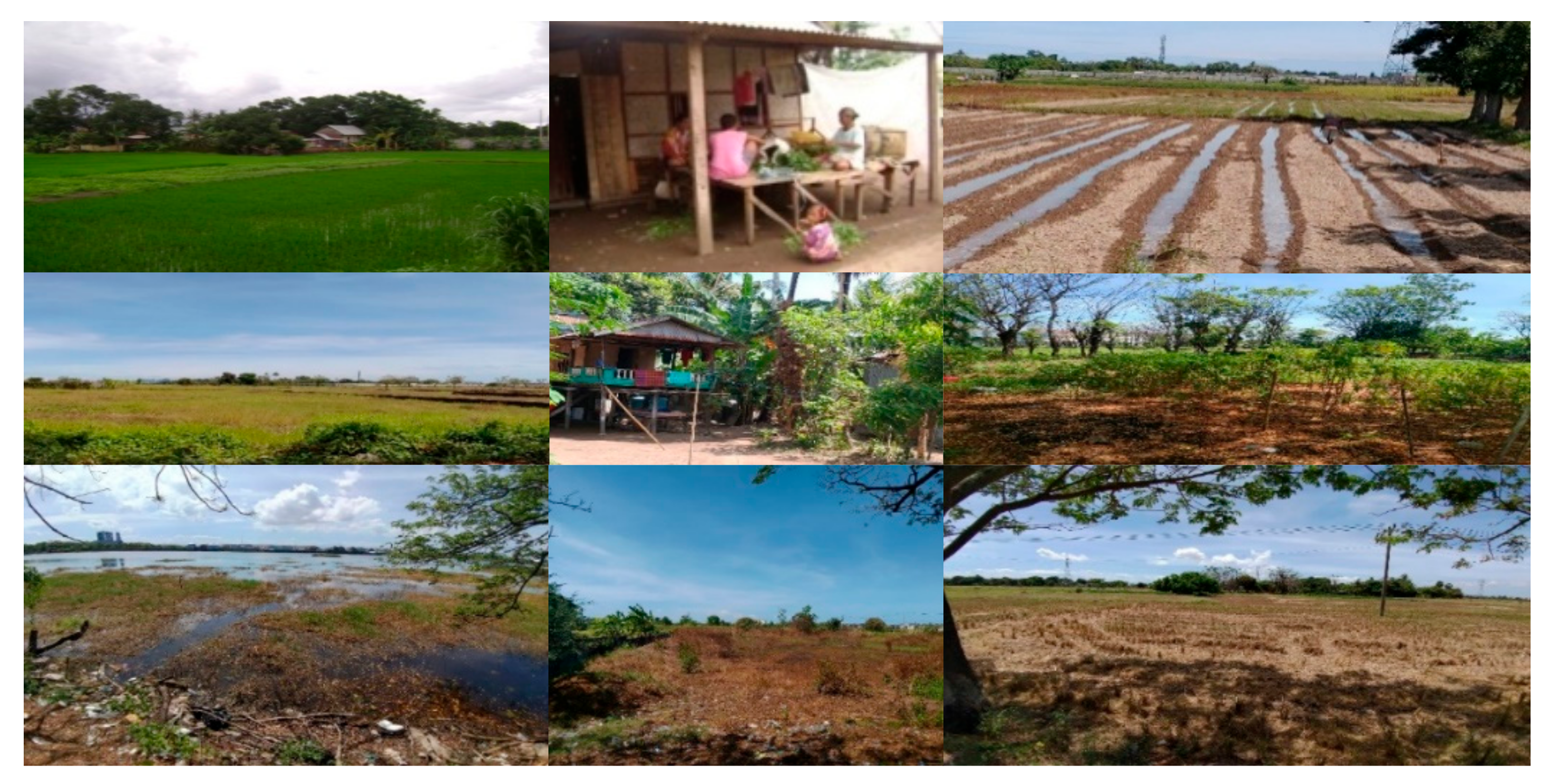
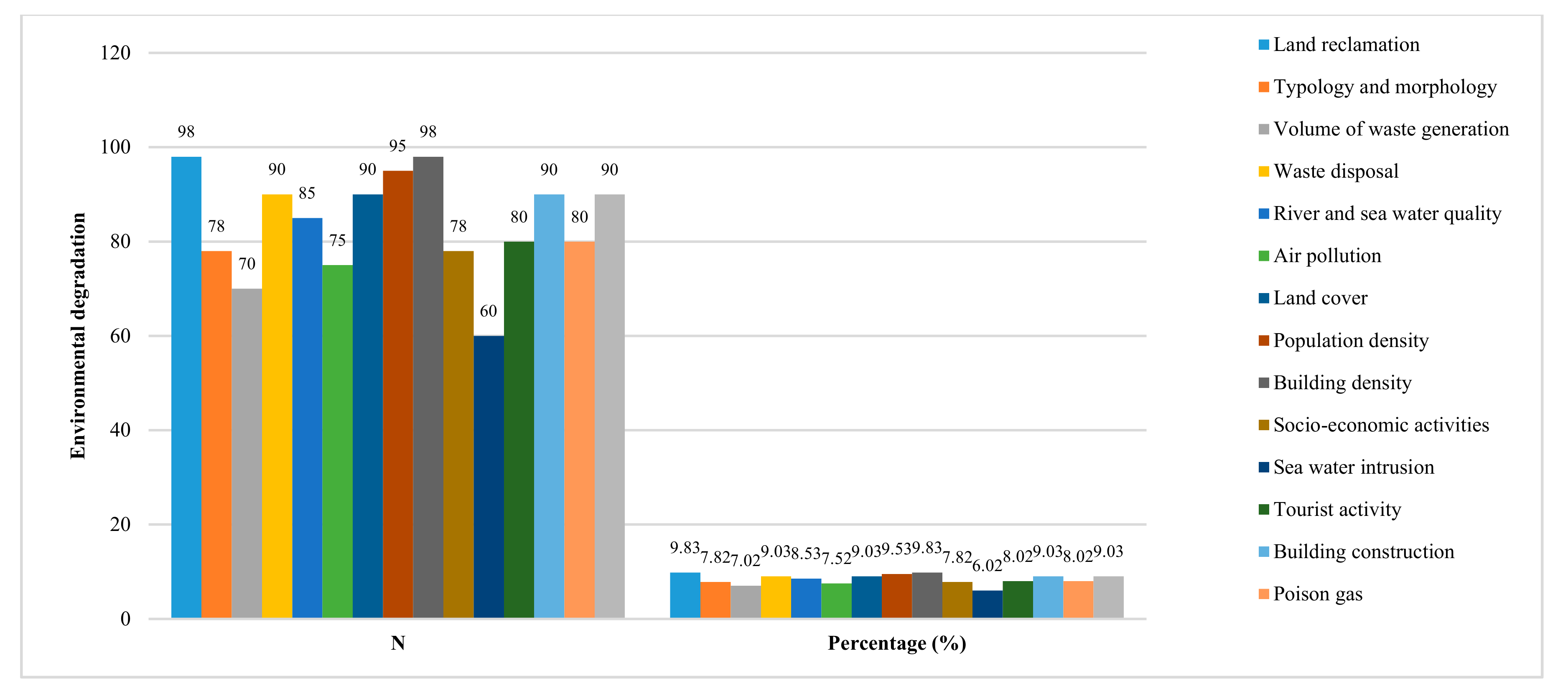
4.2. Spatial Dynamics and Environmental Quality Degradation

Spatial transformation as a determinant of changes in the social formation in the new city area of Metro Tanjung Bunga causes changes in the social mobility of local communities, both vertically and horizontally. Furthermore, the modernization of development has a selective nature and exerts an impact on the formation of community segmentation for individuals who move and evolve until they leave the segment. The informal segment then involutes. This specifically refers to the influx of newcomers and increasing numbers in line with spatial transformation in the new city area of Metro Tanjung Bunga. The dominant commercial space functions develop positively in association with the mode of production of capitalism and contribute to the order of life of the local community. This process was marked by a shift in the orientation of the activities of the local community from farm laborers to construction workers and informal traders, with a small portion moving vertically to become independent entrepreneurs in the villa rental business in the coastal areas that originally relied on their work as farmers and fishermen. The repositioning of the local community’s economic activities dominated by informal economic activities is positively associated with the existence of urban villages in the new city area of Metro Tanjung Bunga as an example of informal city morphology. This transformation and continued evolution of the nature of urbanization brings with it many planning challenges to provide an adequate and equitable supply of basic services, such as housing and land, employment, health, and education, as well as protection of the natural environment [99].
The development of residential areas in bulk, from small segments to large and comprehensive shapes, has an impact on changes in the spatial structure of the new city area of Metro Tanjung Bunga to make it a new independent city. The process of forming a new city in a planned manner has resulted in a gap in urban space which is dominated by expansive settlements of immigrants which are very different in terms of the quality of buildings and infrastructure services for local community settlements. This phenomenon is increasing highlighting the direction of the process of segregation between the occupancy of local communities and migrants—spatially, economically, and socially. Urban segregation describes the unequal distribution of different social groups in the urban space, based mainly on occupation, income, and education, as well as gender and ethnicity [100]. The residential segregation in the new city area of Metro Tanjung Bunga is shown in Figure 13 below.
Figure 13 shows the spatial segregation associated with the residential areas of local communities. Expansive migrant populations are a unique phenomenon. So far, there is natural segregation in urban areas. The new city area of Metro Tanjung Bunga, as a newly developing area, was found to contain different forms of segregation based on the formative process—namely, artificial segregation. This fact can be seen from the emergence of new housing complexes that are designed for certain groups in society. These new inhabitants will gradually form a new community. This condition is marked by the emergence of new forms of housing built by developers, from luxurious to very luxurious types. Urbanization is usually accompanied by complex challenges, including ongoing demands for housing, transportation networks, basic services, and employment [89]. These challenges seem to emphasize the economic and political dimensions of housing far more than the social and cultural dimensions [90].
Social mobility due to spatial transformation in the new city area of Metro Tanjung Bunga causes changes in the social structures of local communities. The nature of these changes is fundamental in terms of changing the social structures of local communities more generally. Furthermore, social mobility in local communities involves movement that occurs in social structures—specifically, the formation of certain patterns that regulate the organization of social groups to increase economic stratification from simple strata to clear strata. Capitalism’s work system has an impact on two main factors: (1) The functional system, which is the mechanism of the division of labor that requires cooperation and equal positions; and (2) the scalar system, which entails the distribution of power according to a power ladder from the bottom-up. Furthermore, the elements of the formed production relations refer to institutional relations, social relations between individuals and community groups, and positive associations with the formation of highly complex social structures. This scale-free behavior of landscape–social relationships challenges the traditional modifiable area unit problem and provides mechanistic insight into the conflicts and compatibilities between human activities and human-induced land use changes [101]. The concept of a nature-based solution has been developed to operationalize an ecosystem service approach within spatial planning policies and practices to fully integrate the ecological dimension and, at the same time, address the current societal challenges in cities [102]. Furthermore, ecosystems have been stabilized by human interventions to optimize the delivery of certain ecosystem services, while, at the same time, awareness has grown that these systems are inherently dynamic rather than steady [103].
Spatial transformation as a determinant of changes in social formation indicates that the developmental dynamics of the new city area of Metro Tanjung Bunga began with the penetration of capitalism into the mastery of spatial reproduction that was originally engaged with by indigenous communities, characterized by a move from rural agrarian to urban industrial society. The field data show that the coexistence of pre-capitalist social formations and the social formations of capitalism in spatial articulation processes that are not running optimally cause social changes in local communities that are marked by the sharpening of strata away from simple stratification. Furthermore, the differences in the ability to access economic resources for the reproduction of space in the new city area of Metro Tanjung Bunga causes marginalization in local communities. This condition is measured by indicators of poverty in local communities, along with physical weakness, alienation, vulnerability, and powerlessness, which are interrelated with one another. The poverty and voicelessness of marginalized peoples were long viewed as an issue of inadequate individual capacity, rather than outcomes of a long socio-cultural and historical process of subordination that resulted in reduced power and limited access to resources and opportunities [104]. Furthermore, the marginalized urban community is a group of people who do not have access to the economic and formal infrastructure of the city [105].
The spatial transformation of the Metro Tanjung Bunga new city area has a positive contribution to environmental degradation due to several factors, including: (1) Land reclamation for housing and settlement development needs due to different land elevations and their impact on urban flooding; (2) changes in the typology and morphology of coastal areas due to massive coastal reclamation impacting the damage and loss of mangrove forest habitats for coastal abrasion control; (3) increasing the volume of waste generation based on the sources of waste (namely, housing and settlements, socioeconomic activities, offices and services, hospitals and education, tourism facilities, hotels, and other socioeconomic activities); (4) environmental pollution due to suboptimal waste management originating from household waste, socioeconomic activities, tourism facilities, and other socioeconomic activities; (5) the pollution of river water and sea water quality due to changes in land cover along river basins and coastal areas; and (6) air pollution due to an increase in the volume of vehicles (both public and private transportation). The deterioration in the environmental quality of the new city of Metro Tanjung Bunga is shown in Figure 14.
Figure 14 shows the decrease in environmental quality in the new city area of Metro Tanjung Bunga. Relevant interpretations are related to a decline in environmental quality, among others: (1) The main trigger for the decline in environmental quality is land reclamation activities. The differences in land elevation in the new city area of Metro Tanjung Bunga are influenced by the development of large-scale settlements due to elevation differences between the inhabitants of migrants and local communities. This difference in land elevation has an impact on the urban flooding experienced by local community settlements, with pools of water reaching 1–1.5 m due to inadequate drainage system support; (2) the high building density and population density have an impact on reducing land cover along river basins and coastal areas that are used by local communities to build residential facilities. The triggering factor here is the inability of the community to access land due to the high land value; (3) the construction of buildings by developers impacting air, soil, and water pollution; (4) decreases in surface water quality (river and sea) due to the high volume of waste generation. Rivers and seas are used as media for the disposal of garbage and waste disposal by local residents, as well as for socio-economic activities due to the lack of integrated waste management support; (5) air pollution originating from motor vehicle exhaust and the tourism industry developing in the new city area of Metro Tanjung Bunga. The functions of economic activities, large-scale settlement development activities, and transportation systems in the new city area of Metro Tanjung Bunga have a significant impact on reducing the carrying capacity of the environment and environmental pollution over time. Therefore, choosing an effective method has become an important issue for analyzing the relationships between regional resources, the environment, and human activities, as well as providing operable and effective regulatory counter measures to achieve a sustainable regional strategy [106,107].

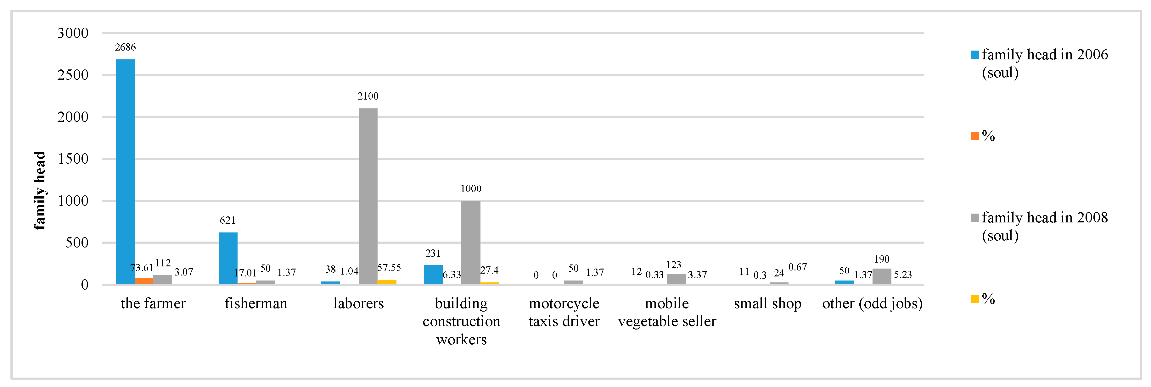
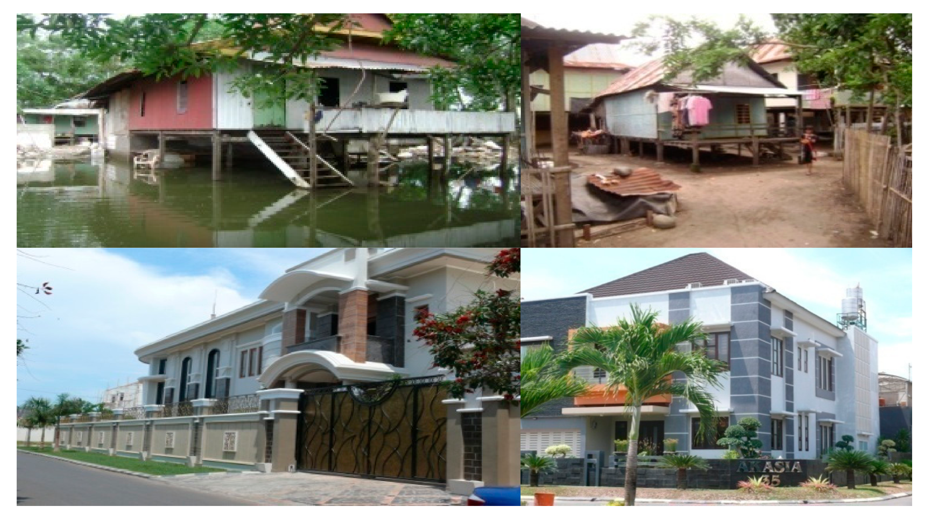
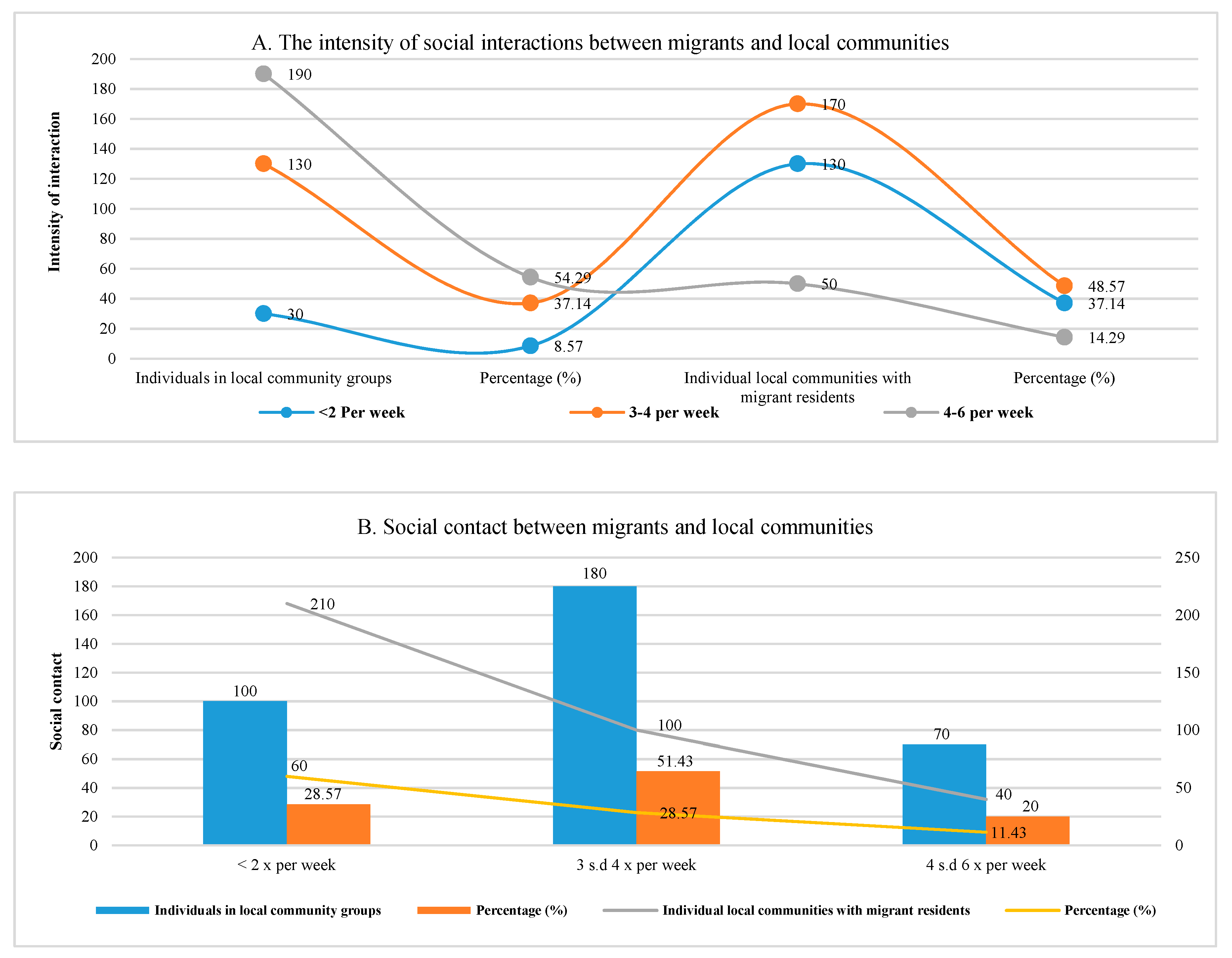
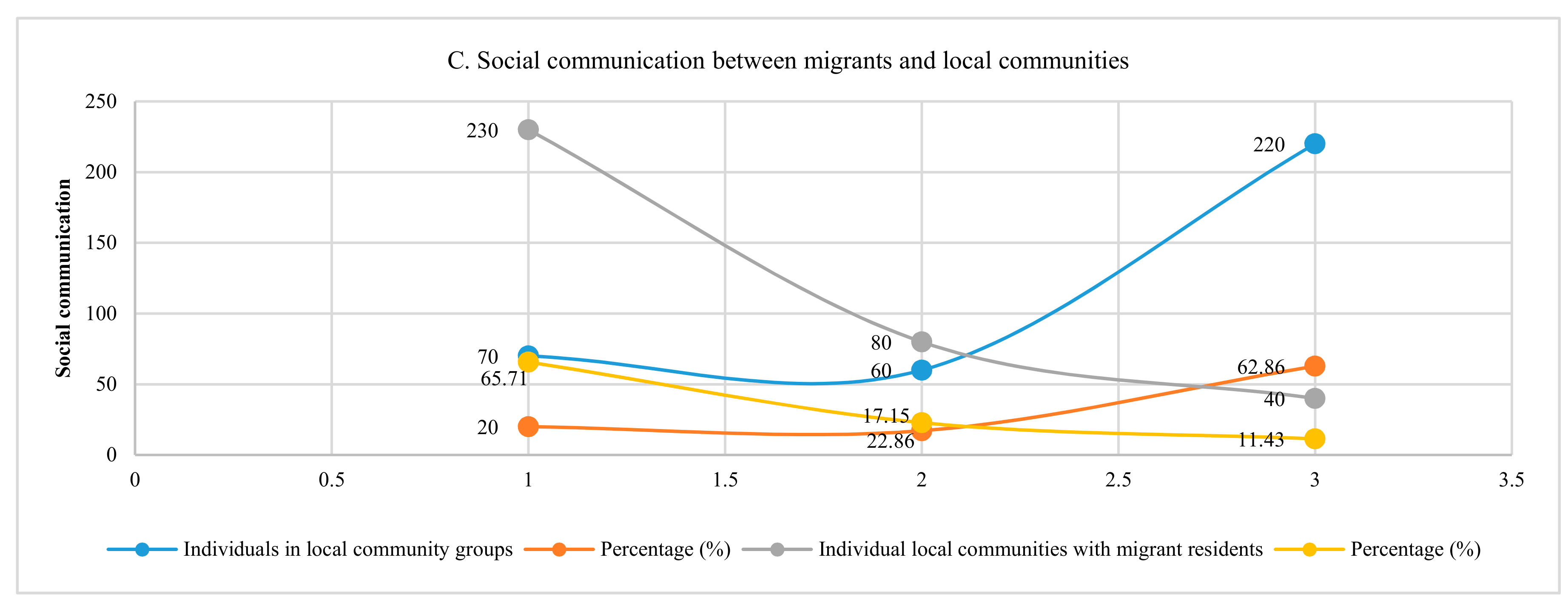
4.3. Social Economy of Local Communities and Migrant Populations

The spatial transformation in the new city area of Metro Tanjung Bunga has an impact on the increase in formal activities that require certain fixed specifications and types of expertise (unlike informal urban jobs).That is, becoming a farmer or informal sector worker does not require special qualifications, but obtaining formal employment does require certain qualifications. The field data shows that the dominant local community is not equipped with sufficient skills or educational background, so they can only obtain informal positions as service workers, construction workers, or services at shopping centers. Furthermore, in non-formal sector activities that do not require expertise, skills, or educational backgrounds, the local community generally engages with business activities, such as working as mobile vegetable trade workers, food stall workers, garbage collectors, public transportation drivers, building construction workers, and motorcycle taxi drivers. A small portion still attempt farming activities on vacant land that has not been utilized by the developer. Thus, spatial transformation has an impact on the differentiation of the work of local communities. The urban socio-spatial structure evolved from a single-core pattern to a single-core pattern with enclaves, ultimately showing a more mosaic tendency toward the differentiation of community work [83]. This has also led to the emergence of polarization and the fragmentation of labor, as well as an increasing acceptance of urban form diversity [108,109,110].
The spatial transformation of the new city area of Metro Tanjung Bunga was caused two simultaneous modes of production: The capitalist mode of production driven by the entry of companies with considerable business capital capabilities and the mode of pre-capitalism production driven by the local community, with limited business capital. The domination of the capitalist mode of production through technological support and investment is the means, by which capitalism is used to build power structures in the new city area of Metro Tanjung Bunga. This is exacerbated by the weakness of local communities in terms of their venture capital and technology. These factors provide trigger for change by marginalizing local communities, leading to resistance, facilitating change over time.
The field data show that there are three levels to the working mechanism of capitalism in the new city area of Metro Tanjung Bunga: Family capitalism, managerial capitalism, and institutional capitalism. These three levels have different characteristics from one another, but they all have the same goal—the creation of the highest profit value. The conceptualization of capitalism by defining its main institutions (individual motivation, law and the State, property and contract, markets, money and finance, firms, employment relations) and, therefore, defining capitalism as an institutional and specific system [111]. Furthermore, in a transitional society, there is a considerable proportion of “unidentified” people who are neither pro-self nor pro-social, suggesting the potential existence of unstable states during the transformation a from rural to capitalistic society [112].
The coexistence of two types of social formations (pre-capitalist and capitalist) has an impact on differences in the mastery of spatial reproduction in the new city area of Metro Tanjung Bunga, leading to the spatial separation of housing locations between the expanding migrant groups and local communities, with a capitalist space on one side and a pre-capitalist space on the other. These differences act as the driving force of social change in local communities. Furthermore, the different orientation of capitalist production and pre-capitalist production in local communities produces types of business, with the orientation of subsistence production on the one side and the orientation of commercial production on the other. Social relations in pre-capitalism social formation are characterized by kinship relations and employer-worker relations in the social structure: (i) Subsistence-oriented local communities, kinship-related social relations, and (ii) local communities that are focused on commercial production. Work relations between owners and workers are developing a social structure that will increase economic stratification. Furthermore, the social formation of capitalism is characterized by social polarization, with the arrangement of society based upon the relations between social classes. The field data show that the social relations in the organizational system of capitalism production can be divided into three types of relationships: Egalitarian, class-based, and transitional (as intermediate types). In the history of capitalist societies, the ecological conditions of social reproduction have been largely ignored or downplayed. Only the exacerbating ecological crises of recent decades have forced economists, policy makers, and the common public to pay more attention to the natural limits and the conditions of sustainability [113]. Differences in the production procedures for the social formation of the new city area of Metro Tanjung Bunga are presented in Table 3 below.
Table 3 illustrates the development of two related modes of production, with the production of capitalism on the one side and the mode of production of pre-capitalism on the other. There is a very significant difference between these six distinguishing categories. There are three important categories that, in principle, highlight the most basic distinguishing elements: The forces of production and the relations between production, technology, and investments. Furthermore, the built social formation creates changes in the social interactions and adaptations between migrants and local communities. The social interactions between migrants and local communities in new social formations are valued based on the intensity of the interaction, ongoing social contact, and communication built between individuals in the local community and between those in the local community and migrants.
Figure 15A shows the intensity of social relations that take place between the individuals of local communities and migrants. Potential interpretations related to social interactions include the following: (1) The intense social interactions in local community groups take place in a kinship atmosphere with a frequency of interaction 4–6 times per week or 54.29%, and the pattern of social relations is reciprocal. (2) The intense interactions between individual local communities and migrants occur with a frequency of 3–4 times per week or 48.57%, and the patterns of social relations are not reciprocal. These interactions reveal several factors: (i) The social relations of the local community take place in an atmosphere of kinship and shared life patterns for the unity of the local community based on shared interests and (ii) the social interactions between local communities and migrants is more work-related, using business activities as a medium for social interaction.
Figure 15B shows three categories of ongoing social contact: (1) The social contact between individuals in local community groups is very intensive, with a frequency of 3–4 times per week or 51.43%, and (2) the social contact between local communities and migrants has a frequency value of <2 per week or 60.00%. The process of social interaction based on ongoing social contact reveals the following: (i) The social contact that takes place between individuals of a local community presents a familial atmosphere that is bound by blood ties based on lineages, and (ii) the social contact between local communities and migrants is more work-related, and communicative relationships built more for workers’ control and economic effort serves as a medium for ongoing social contact. Labor that is quantitatively relevant reflects structural, economic, and social transformation [20].
Figure 15C shows this ongoing social communication. The following factors can be disclosed: (i) Social communication in local community groups is very intensive at 62.86%, and the frequency of social communication is 4–6 times per week; (ii) social communication that takes place between local communities and migrants is 65.71%, with a frequency of social communication of <2 per week. Ongoing social communication relates to a number of factors: (i) Social communication within the local community group still relies on the principles of togetherness, as indicated by the high tolerance and principle of mutual help when experiencing difficulties, in addition to having a mutual desire—both economically and socially—towards improving welfare; (ii) the social communication shown between the local community and the migrant population is more of a working relationship, where control over workers and social communication is built only under certain conditions and situations. The elements of good communication, linguistic barriers, and cultural differences play an important role in the effective application of relevant interventions [114].
The three things studied (intensity of interaction, social contact, and social communication), show differences. The proposed interpretation related to social interaction is as follows: (i) The process of social interaction within local community groups shows the functions and roles of the actors who interact, are in the same social position, and are intensively oriented in their daily lives towards their groups as a community unit bound by blood ties and the principle of togetherness; (ii) the process of social interaction between individuals of the local community and migrants is more defined by the patterns of work relations. This means that ongoing social interactions situate migrants who are economic business owners in a higher position, and the social relations that take place relate more to economic motivation; (iii) the process of social interaction between individual local communities and migrants is more service oriented. This means that the social interactions that take place are more mutually beneficial to both parties. In this case, the local community receives a service fee, and the migrant population gains profit and profit value. The reasons for migration can be numerous, including social, political, economic, and environmental factors [115].
The rapid and revolutionary spatial transformation in the new city area of Metro Tanjung Bunga is a trigger for the ongoing process of social adaptation at the individual level in the local community. The current social adaptation being observed is based on changes in the work orientation of the local community, which were initially relatively homogeneous and characterized by a rural agrarian society (agriculture and fishermen) and then developed in a heterogeneous direction with complexity as a characteristic. This complexity arose with the development of new functions in the new city area of Metro Tanjung Bunga. This process of social adaptation demonstrates the existence of different levels in the adaptation of individual local communities. These conditions are characterized by the development of social differentiation, social status, and social classes. That is, spatial physical change, as a stimulus, conditions individual differences in response to environmental changes, resulting in differences at the level of individuals in the adaptation process. Modernization in the new city area of Metro Tanjung Bunga has a dualistic nature: It conditions different adaptation processes between both individuals and individual local communities. Spatial physical change is a driving force for social mobility (both vertically and horizontally) to maintain the existence of local communities. There are two categories of spatial transformation: (i) The process of the social adaptation of local communities and (ii) the process of the social adaptation of migrant populations, which are both infiltrative and expansive.
Changes in the orientation of the work of local communities in the new city area of Metro Tanjung Bunga were initially modest (traditional agrarian). Then, the area moved towards an urban industrial society. This process of change is characterized by the development of new strata and social statuses in local communities based on specialization and expertise. This reorientation is related to changes at the system level through stages involving new special functions. The process of social adaptation that occurs then encourages the development of social differentiation to carry out new functions in the family due to modifications in the lives of the local communities, which are influenced by high internal and external needs, especially in terms of meeting the needs of life.
Spatial–physical changes that take place quickly and are revolutionary have an impact on changes in the social fabric of local communities and are variously marked by the development of local community activities as a form and adaptation response to a situation of environmental change. Some individual community groups have a high adaptive capacity. However, the adaptive power of individuals of a local community is also weakened in this context, making it difficult for the systems of this group to accommodate new situations. This condition is generally represented in local communities by subsistence farmers. The development of business activities in the new city area of Metro Tanjung Bunga shows the different levels of adaptation in the local community based on the level of income obtained to maintain the community’s existence. The work currently undertaken by the local community shows that the existence of the local community, based on its adaptation process, rests in a position of uncertainty. There are only two orientations for the activities of the local community that are in a normal position based on their level of income obtained: The mobile vegetable trade and formal work based on the routine income earned. Both, of these business activities have a more stable level of adaptation compared to other work orientations.
For the social adaptations of local communities in the new city area of Metro Tanjung Bunga, the following interpretations can be determined: (1) Differences in the level of adaptation in local communities indicate the ongoing differentiation of work in the lives of local communities, and (2) the level of income earned today is strongly influenced by the response of the local community to the situation of environmental change. Thus, the differences shown in the level of adaptation have a positive effect at the system level and the stages that must be passed by the local community. That is, changes at the local community system level are highly dependent on the level of adaptation in responding to environmental change stimuli. Thus, it can be concluded that the process of the social adaptation of local communities occupies a transitional position and is highly dependent on the ability of individuals to respond to environmental stimuli. The adaptive capacity shown is a form of response to the stimulus of environmental change due to the reproduction of space driven by capitalism. Furthermore, the rationalization of action is the driving force of individuals in local community groups underpinned by economic motivations to improve welfare. Individual corporations are looking beyond traditional profit-making goals, rethinking their impacts on society and the environment, and seeking to identify ways to cultivate positive and sustainable relationships with stakeholders [116]. Furthermore, improved social and environmental performance can provide both tangible benefits, such as cost reduction and risk management, and intangible benefits, such as enhanced reputation and increased competitiveness [117].
The dominance of the procedures for the production, of capitalism in the new city area of Metro Tanjung Bunga began with mastery of the factors of production for modernization. Modernization has a dualistic nature—in this case, with informal activities on one side and formal activities on the other. Formal activities that take place in relation to spatial functions have an impact on socio-economic inequality. Furthermore, the social adaptation process of the migrant population is more towards a formal work system mechanism for the urban industrial society, followed by the rationalization of action. The economic and social changes in modern society have resulted in intensive and extensive migrant activity [118].
The process of social adaptation between local communities and migrants shows that there are significant differences between the two groups marked by shifts in normative space and the rationalization of actions in developing economic business activities with new social formations. The types of business activities developed in the pre-capitalist formation tend to shift towards a type of transition, while the social formation of capitalism tends to remain in a position of balance and dominance. These two social formations are then followed by a rationalization of the actions of each community. A comparison of the process of normative space shifts and the rationalization of actions in relation to the process of social adaptation between migrants and local communities is explained in Table 4 below.
Table 4 provides a description of the different adaptive capacities of the community (local communities and migrants). Interpretations can be made regarding the process. First, the spatial transformation of the new city area of Metro Tanjung Bunga caused changes in social formation in line with the development of investments, technology, and management. In capitalism, production is categorized as high. The procedure for the production of capitalism is strongly influenced by investment support, technology, and modern management in the form of general cooperation and building a network of investment cooperation within the framework of mastering production factors due to economic motivations and business opportunities. In the pre-capitalism social formation, the development of investments, technology, and management is categorized as low. This condition is greatly influenced by the ability of local communities to access very limited sources of venture capital. Likewise, the investment network is also very limited, and the ability to master technology remains relatively simple. The pattern of economic business development tends to be simple and only aims at meeting subsistence needs; this pattern is more independent as an adaptive response to the stimulus of physical environmental change. At the microlevel, the outcomes of the school-to-work transition can be related, for example, to occupational status, education-job mismatch, wage and wage growth, security of employment, job and career mobility, participation in training, and job satisfaction [119,120,121].
Second, the shift in normative space in the pre-capitalist social formations and capitalist social formations also shows a difference related to the procedures of production, both of which go hand in hand. The shift of normative space in the social formation of capitalism is categorized as high. This condition occurs due to the production procedures and working systems of capitalism that are contractual and collective, based on the ability of individuals to reach a position. That is, position and status are largely determined by the adaptive capacity of individuals to achieve achievements in the working system of capitalism, thus giving birth to formal urban industrial working classes. Furthermore, in pre-capitalism social formations, the shifts in normative space are categorized as moderate. This condition occurs because the influence of values and traditions are still quite strong, so the principles of togetherness are still characteristic, and individuals tend to exist in social groups. Thus, the development of social classes does not directly affect the production procedures implemented. Moreover, individuals’ positions and statuses tend to be similar; even though social polarization has occurred, its effect is not significant. Social polarization occurs when the income inequality between ethnic groups is taken, into account [122].
Third, that the process of the social adaptation of local communities in new social formations is followed by the rationalization of actions. In the pre-capitalism social formation, the rationalization of actions is categorized as moderate. This condition occurs due to the influence of spatial transformation, which becomes a driving force in the adaptation process of local communities for the purpose of maintaining their existence and achieving prosperity, as well as motivations for achievement. Furthermore, the working system of capitalism is perfectly structured for different conditions. That is, the more developed the stratification is for status and working classes, the more this stratification will economically benefit capitalism to achieve the highest profit. Complex adaptive systems consist of a multitude of agents, from whose individual adaptation efforts the adaptive behavior of the system as, a whole emerges. At both levels (the level of the individual agents and the level of the system as a whole), viability is contingent on proper adaptation to the environment [123].
The coexistence of pre-capitalist social formations and the social formations of capitalism shows that the existence of capitalism in the new city area of Metro Tanjung Bunga dominates economic production activities for the creation of space in a representational manner. This means that the domination of capitalism production procedures in the dynamics of the development of the new city area Metro Tanjung Bunga presents a difference in adaptation capacity and a weak ability to control production factors by local communities. Thus, differences in the level of adaptation of the local community are largely determined by the ability to articulate the existence of new urban spatial functions driven by capitalism. The coexistence of these two interrelated modes of production ensures that the mode of production of capitalism dominates the factors of economic production in the new city area of Metro Tanjung Bunga. Thus, the transition controlled by an articulation of the two modes of production—in this case, the mode of production of capitalism and the mode of non-capitalist production—shows that the existence of capitalism is increasingly dominant (or will become more dominant) within the modes of production of the local communities. In real life, the actual conditions for the accumulation of aggregate capital are quite different to those for individual capitals and simple reproduction [124].
The transfer of land use functions and the conversion of productive agricultural land to changes in spatial use have led to a change in the single social formation of local communities characterized by the transformation of rural agrarian formations into dual social formations due to the spatial functions that developed in the new city area of Metro Tanjung Bunga impacting the differentiation of the work of local communities to change social interactions and adaptations. The consequence of changes in interactions and social adaptations causes changes in the social structure that sharpen the social stratification, social status, and cultural patterns of local communities from traditional agrarian to urban industrial models. This process of change will always continue and is highly dependent on the spatial dynamics of the new city area of Metro Tanjung Bunga, Makassar City. Thus, decision making and development policies from the government in favor of marginal communities are needed due to the lack of responses in changing the relevant environmental stimuli and access to the economic resources of the city. This will involve the formulation of policies to meet political, socio-economic, and environmental interests [125]. Furthermore, the effects of changes in spatial use, social formation, and work differentiation on the socio-economic sustainability of local communities are shown in Table 5, as follows.
Table 5 shows the effects of changes in spatial use, social formation, and job differentiation on the socio-economic sustainability of local communities. Several explanations related to these results were proposed: (i) Changes in spatial use have a positive effect on the socio-economic sustainability of local communities; (ii) changes in social formation have a positive effect on the socio-economic sustainability of local communities; (iii) job differentiation has a positive effect on socio-economic sustainability in the local community; (iv) changes in spatial use, social formation, and job differentiation simultaneously have an influence on the socio-economic sustainability of local communities; and (v) the effects of changes in spatial use, social formation, and job differentiation explain 97.7% of the social sustainability of the local community economy in the new city area of Metro Tanjung Bunga, Makassar City.

5. Discussion

The spatial transformation of the new city area of Metro Tanjung Bunga, Makassar City, has had an impact on the attachment of local communities to traditions that are hereditary and have experienced a downward trend. Once always obedient to its traditions, this community is now either no longer fully obedient (only carrying out part of the tradition) to being completely disobedient (no longer practicing the tradition). Consequently, the value system will change when the type of community changes, and norms will also change.
Spatial transformation coupled with changes in social formation causes changes in social interactions and social adaptations and impacts social change internally at the local community level of the new city area Metro Tanjung Bunga. Changes in social structure, characterized by sharpening of economic stratification, and interactional changes due to differences in social interactions between local communities and migrants cause changes in the social systems of the local communities. Furthermore, cultural change is characterized by the development of traditional agrarian societies into urban industrial societies. Changes in the social interactions within local communities based on their patterns and structures were initially characterized by tight social ties (gemeinschaft) and then developed towards voluntary and contractual social ties (gesselschaft). These changes have had an impact on the fragmentation of local community life. That is, the social relations of local communities are still traditional agrarian, while urban industrial community relations develop new social formations that are fully influenced by the spatial transformations that take place quickly and revolutionarily in pursuit of economic growth. Furthermore, awareness of the risks of the collapse of the natural system have begun to spread as, a consequence of the traditional development associated exclusively with economic growth [126].
The consequences of local community developments in the new city area of Metro Tanjung Bunga in this new social formation include (i) sharpening economic stratification from simple stratification to clear strata; (ii) differences in status, from a fully ascribed status to an achieved status based on one’s efforts and achievements, as well as expertise and skills to meet one’s needs; (iii) changes in the social system of the local community toward an open social system; and (iv) changes in social values and norms from a fully traditional agrarian life to an urban industrial society. Thus, the spatial transformation that results in new social formations has had an impact on social change in the local community of the new city area of Metro Tanjung Bunga. Furthermore, spatial transformation caused a shift from agricultural activities characterized by rural and homogeneous agriculture to changing the means of production to reproduce the space dominated by commercially characterized urban spatial functions. Understanding the characteristics of rural landscape change during the urbanization process is crucial to developing more elaborate rural landscape management plans for sustainable development [127].

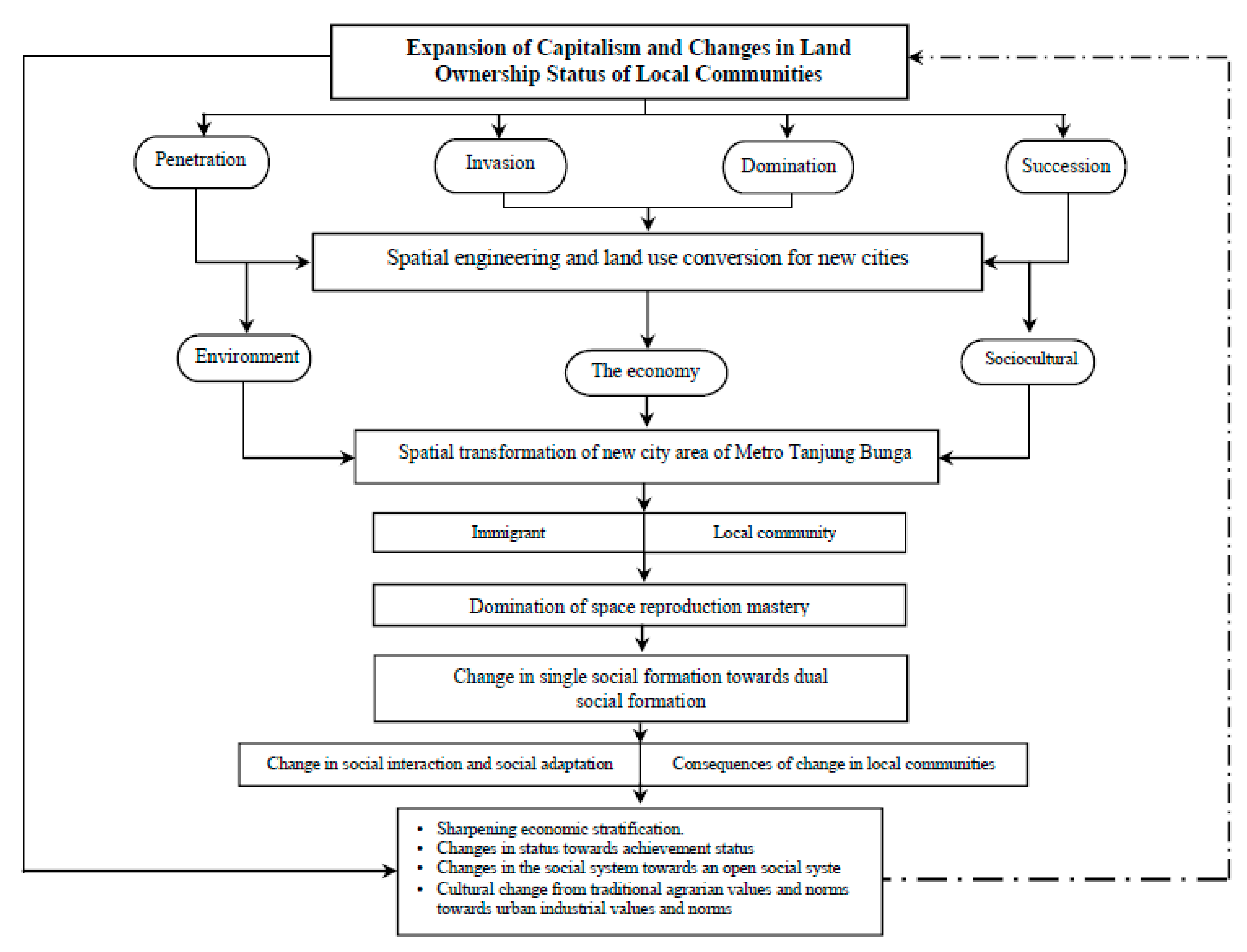
5.1. Spatial Transformations, Social Formations, Social Interactions, and Social Adaptations

Spatial transformation as a determinant of changes in social formation is initially characterized as a single and homogeneous social formation before transitioning towards multiple social formations, including pre-capitalism and capitalism, thereby causing changes in the social interactions and social adaptations between local communities and migrants in the new city area of Metro Tanjung Bunga. Changes in social interactions and social adaptations cause social changes in local communities. The consequences of internal social changes in local communities are marked by sharpening economic stratification and a change in cultural patterns from traditional agrarian to urban industrial. Thus, there is a relationship between the spatial transformation of changes in social formation and the changes in social formation related to changes in social interaction and social adaptation, as well as the consequences of changes at the local community level of the new city area of Metro Tanjung Bunga. Sustainability is often conceived of as an attempt to balance competing economic, environmental, and social priorities [128]. The general social changes in local communities in the new city area of Metro Tanjung Bunga are shown in Figure 16 below.
Spatial transformation as a determinant of changes in social formation, which causes changes in social interactions and social adaptations and affects local communities, is a social phenomenon observed in the development of the new city area of Metro Tanjung Bunga, which was developed in an integrated manner and supported by the development policies of the government. This collaboration became the driving force behind the expansion of capitalism through the process of penetration, invasion, domination, and succession in land tenure to develop the functions of urban activities in the new city area of Metro Tanjung Bunga. The reality that the expansion of capitalism penetrates, into the pre-capitalism space reflects the domination of the reproduction of space by capitalism, leading to marginalization and social change in the local community. Thus, the practice of formalization aims to eliminate informality. The main challenge is to explore complex informal/formal relationships and the dynamics of street trade to understand how forms of informality negotiate space and visibility in the public sphere [129].
Marginalization in local communities, due to spatial transformation and changes in social formation, has an impact on differences in ability, as well as differences in rights and access to economic resources, as well as the reproduction of space between two coexisting social formations. Justification for marginality in local communities is assessed based on several indicators: Poverty, physical weakness, isolation, vulnerability, and powerlessness in the mastery of spatial reproduction and access to spatial functions in the new city area of Metro Tanjung Bunga.
The reality that spatial transformation works as a determinant begins with changes in the status of land ownership and the transfer of land use functions from the dominance of agricultural functions to the dominance of commercial functions. This process caused a shift in production facilities towards the reproduction of space in the new city area of Metro Tanjung Bunga. That is, the coexistence of these two types of social formations and the dominance of the mastery of spatial reproduction by the social formations of capitalism, alongside the articulation of two types of social formations that are not running optimally, produce marginalization in local communities.

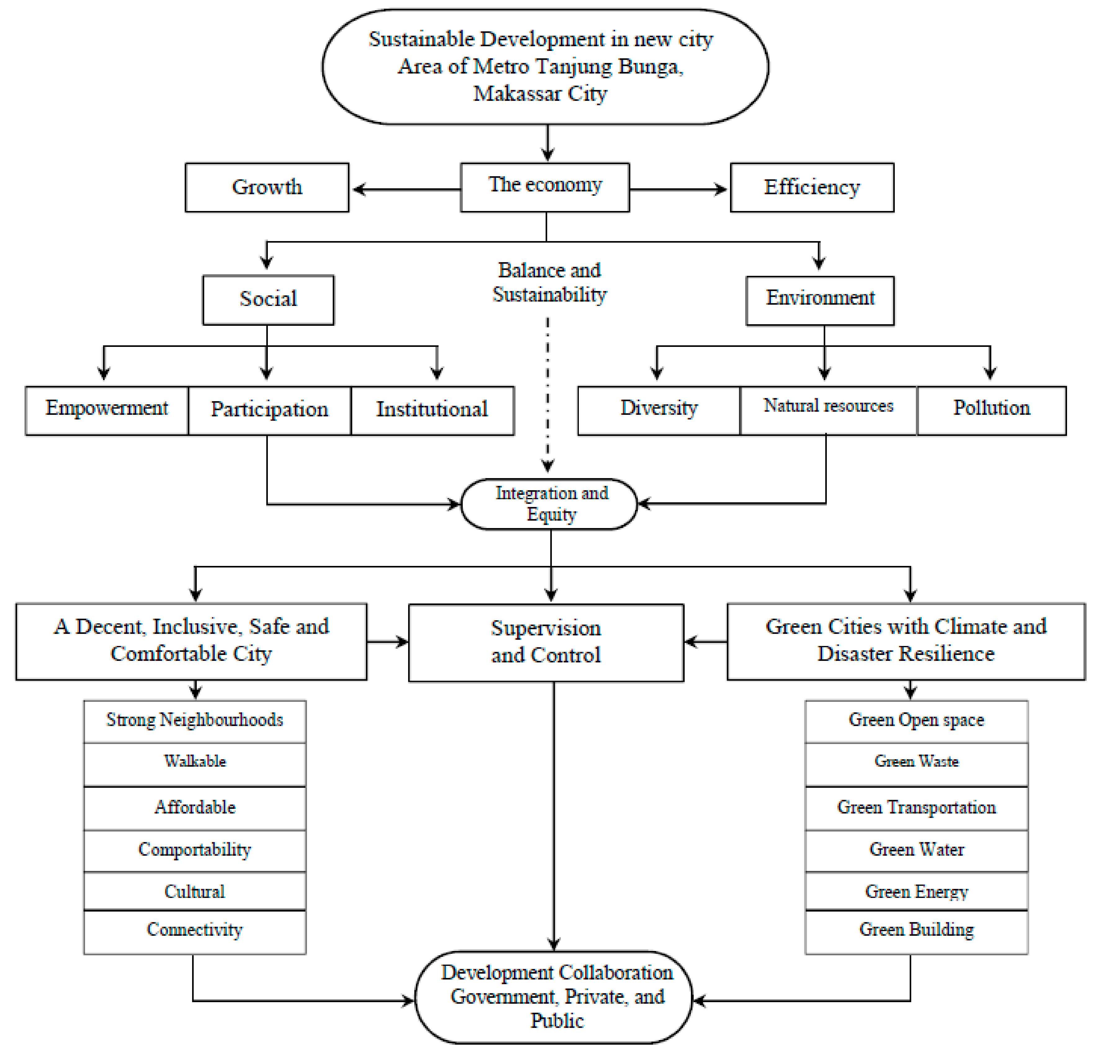
5.2. Sustainability Development in the New City Area of Metro Tanjung Bunga

Sustainable development of the new city area of Metro Tanjung Bunga is primarily intended to improve the welfare of the community through efforts to optimize the use of space without ignoring the needs of future generations. Spatial engineering for sustainable city development is a development necessity from three perspectives: Environmental, economic, and social. Furthermore, sustainable development is formulated for the purpose of building shared awareness of inclusivity, economics, social justice, and ecological survival. Moreover, the sustainable development of the new city area of Metro Tanjung Bunga is a conscious and planned effort to integrate the environment and resources into the development process to guarantee the capabilities, welfare, and quality of life of present and future generations. Cities with a lower dependency on physical and economic growth are more likely to emphasize the quality of the built environment and address issues of sustainable urban development closely when planning and implementing new town projects [130].
The concept of sustainable development in the new city area of Metro Tanjung Bunga is based on three main principles: (i) Physical environmental sustainability, (ii) economic sustainability, and (iii) social sustainability. These three basic principles will require decision makers and government policies to optimize the roles of stakeholders (namely, the government, the private sector, and community participation). Sustainable development governance refers to a combination of the rules and decision-making processes of civil, private, and public actors, which together shape the future [131]. Thus, it is very important to formulate and evaluate the conditions of the new city area of Metro Tanjung Makassar to develop the area towards the concept of an eco-city, with consideration of three main elements: People, the planet, and profit. This will facilitate natural resilience, nature, food security, and energy security. A major challenge that can undermine the use of resilience for guiding planning activities is the value-laden and contested nature of the concept that can be interpreted in a variety of ways [132].
The orientation of sustainable development in the new city area of Metro Tanjung Bunga entails dialectics that position the economic, social, and environmental dimensions as the three main unified pillars of life systems and urban systems that are integrated into spatial structures and spatial patterns that fulfill a sense of justice, inclusiveness, and competitiveness. The sustainable development of urban space along with its economic and social benefits considering quality of life and the ecological environment has become a new and important subject that needs to be explored [133]. Furthermore, if the economic and social dimensions are considered to represent development goals, then both need to have a relationship with the environmental dimension, including natural resources. The orientation of sustainable development in the new city area of Metro Tanjung Bunga Makassar City is shown in Figure 17 below.
Figure 17 shows the concept of sustainable development in the new city area of Metro Tanjung Bunga, Makassar City. This concept is based on several factors, including (1) creating a safe, comfortable, and livable city by (a) providing basic facilities and infrastructure in accordance with the typology of the new city area; (b) improving health, education, and socio-cultural services; (c) developing housing in accordance with the typology and land characteristics of the new city area of Metro Tanjung Bunga; (d) developing a public transportation system that is integrated with urban and multimodal systems in accordance with the typology and geographical conditions of the new city area of Metro Tanjung Bunga; (e) providing and improving economic infrastructure, namely trade and services and other economic activities; and (f) improving the security of the new city area of Metro Tanjung Bunga through prevention, a provision of facilities, and criminal and conflict management systems, as well as empowering the community by optimizing the use of social capital, specifically for local communities that are marginalized as a result of changes in the work orientation of rural agrarian communities to urban industrial models. Urban-rural linkages are an integral part of fostering development in both urban and rural communities [134].
Second, the new city area of Metro Tanjung Bunga Makassar City is part of the urban settlement area that needs comprehensive planning support to be implemented and well managed. This process, in its implementation, is done to realize housing facilities by incorporating elements of environmental parks with three main considerations: Ecological, aesthetic, and social. Thus, the development of new settlement areas in the future will be able to support residential areas that are livable, inclusive, and sustainable. In this way, the process that involves the participation of the population in the analysis of problems and actions represents an adequate approach to achieve shared goals based on real needs [135,136].
Third, the development of the new city area of Metro Tanjung Bunga is expected to solve the main problem of Makassar City—reducing surrounding rural migration and population mobility due to regional economic development and positively contributing to the sustainable economic growth of Makassar City. Thus, the sustainable development of the new city area of Metro Tanjung Bunga is oriented toward the implementation of an environmentally friendly independent city by integrating environmental management, including resources, into the development process to ensure the capabilities, welfare, and quality of life of present and future generations. The sustainability approach is committed to conserving natural resources and biodiversity. Indeed, sustainability is needed ensure a future for the Earth [137,138].
Fourth, the new city area of Metro Tanjung Bunga, Makassar City, was developed considering six main targets, which were implemented effectively and efficiently. The six principles are the presence of strong neighbors, walkability, affordability, comfortable, culture, and connectivity. The new city area of Metro Tanjung Bunga is also being developed as a green city with climate and disaster resilience through (i) the fulfillment of a 20% green open space to meet public needs for green open spaces; (ii) integrated community-based waste management supported by the provision of waste water management facilities before being channeled into rivers and the sea; (iii) integrating a multimodal transportation system, thereby reducing and limiting the use of private modes of transportation and providing green open road spaces along the Metro Tanjung Bunga road corridors; (iv) controlling land use development on the river and sea border through the conservation of land and water resources since the new city area of Metro Tanjung Bunga is located in the Makassar Strait coastal area and crossed by the Jenneberang watershed; (v) optimizing the use of renewable and environmentally friendly energy; and (vi) developing private green open spaces in multi-storey buildings, such as hotels and shopping centers. Furthermore, the implementation of urban farming is oriented toward regional and household scales. The goal of an environmentally friendly city is to bring harmony to the three pillars of sustainable development—social, economic, and ecological components—to create a sustainable environment [139,140].
Fifth, strengthening the institutional capacity of the government in the supervision and control of spatial use control in the new city area of Metro Tanjung Bunga through efforts to limit permits for land use functions and the conversion of productive agricultural land to ensure food security, especially in surrounding rural areas, as well as strengthening the community’s institutional capacity based on the socio-economic empowerment of local communities to increase the productivity of economic enterprises that are mutually beneficial between migrants and local communities. These five components will help achieve environmental and economic sustainability and facilitate sustainable justice between communities and social cohesion in the future development of the new city area of Metro Tanjung Bunga. The most vital function of cities is to provide affordable infrastructure and an institutional environment that enables migrants and other marginalized urban communities to contribute to urban prosperity and problem-solving with their skills, networks, and entrepreneurial minds [141].

6. Conclusions

The collaboration between the government and capital owners in the development of the new city area of Metro Tanjung Bunga has accelerated the process and produced very complex spatial transformations. Changes in the use of space via the penetration of capitalism cause changes in the means of production through a reproduction of space. Intense changes in spatial use produce the social formation of capitalism alongside the social formation of pre-capitalism in multiple social formations. The coexistence of these two types of social formations in the control of spatial reproduction, which is dominated by the social formation of capitalism, engenders powerlessness among local communities in their access to spatial reproduction resources and has an impact on the marginalization and poverty of local communities. Furthermore, labor differentiation causes changes in social interaction and social adaptation, yielding different modes of production between migrants and local communities. These different modes of production are positively associated with economic inequality in the control of spatial reproduction and reinforce capitalism’s dominance of spatial control.
Marginalization in local communities, due to spatial transformation, has an impact on differences in ability and differences in rights and access in utilizing economic resources between the two coexistent types of social formation. Marginality in local communities is characterized by poverty, physical weakness, isolation, vulnerability, and powerlessness in the control of spatial reproduction and access to spatial functions that are developing in the new area of Metro Tanjung Bunga. Furthermore, the domination of the control over the factors of production by capitalism has led to a change in the work system of traditional agrarian societies towards urban industrial societies. The difference in the level of adaptation of local communities is largely determined by the ability to articulate the existence of spatial functions in the new urban area driven by capitalism. The coexistence of two production modes that go hand in hand has resulted in the production methods of capitalism dominating the economic production factors in the new area Metro Tanjung Bunga.
The change from a single social formation into multiple social formations causes changes in the social interactions and social adaptations between local communities and migrants. Under the conditions of multiple social formations, the social interactions and social adaptations engaged in by local communities become more complex. Internally in the social formation of pre-capitalism, interactions and adaptations are characterized by gemeinschaft and externally with social formations of capitalism, interactions and adaptations are characterized by gesselschaft. Thus, spatial transformation coupled with changes in social formation produces job differentiation as part of the existence of local communities in the new city area of Metro Tanjung Bunga, Makassar City. The consequences of internal social change in local communities include the sharpening of social stratification from simple stratification to a clear stratum, differences in status from ascribed status to achieved-status, which vary according to the efforts made based on one’s expertise and skills, changes in social systems towards more open social systems, and cultural changes from traditional agrarian values and norms to the values and norms of urban industrial society.
The future development direction of the new city area of Metro Tanjung Bunga will involve fulfilling three main components: Environmental sustainability, economic sustainability, and social sustainability. These three components require decision support and policy support from the government. Sustainability in the new city area of Metro Tanjung Bunga is being developed in the direction of a safe, comfortable, and livable city. Settlement development through the support of comprehensive and well-managed planning is positively associated with reducing rural migration and population mobility to facilitate the economic growth of Makassar City. The implementation of the development of the new city area of Metro Tanjung Bunga in the future requires the principles of strong neighborhoods, walkable, affordable, comportable, cultural, and connectivity. Thus, the new city area of Metro Tanjung Bunga requires strengthening the institutional capacity of the government in supervision, controlling spatial use, and limiting permits for land use changes and the conversion of productive agricultural land to provide food security, disaster resilience, and energy security. Furthermore, strengthening the institutional capacity of the community will be necessary for the socio-economic empowerment of local communities to increase the productivity of economic enterprises that are mutually beneficial for both migrants and local communities to realize environmental and economic sustainability and thus create sustainable justice and social cohesion between communities.

Author Contributions

B.S., S.S., conceptualization; B.B., E.S.R., and H.H. compiled the research; B.S., E.S.R., F.M., and A.T.F. designed the methodology; B.S., S.S. H.H., F.M., E.S.R., and A.T.F. processed the data; B.B., A.T.F., and F.M. contributed to the materials/methodology/analysis tools; B.S., B.B., and H.H. analyzed the data; H.H., E.R., and E.S.R. contributed to the examination of the data; B.S., H.H., B.B., A.T.F., E.S.R., and F.M. wrote and revised the draft. All authors have read and agreed to the published version of the manuscript.

Funding

This research was funded by the Government of the Republic of Indonesia through the Ministry of Research and Technology in the form of development research grant assistance.

Acknowledgments

We are grateful for the participation of the stakeholders in contributing ideas for carrying out this study. Thank you to the Ministry of Research and Technology of the Republic of Indonesia for their support and financial assistance in carrying out this research.

Conflicts of Interest

The authors declare no conflict of interest.

References

  1. Surya, B. Globalization, Modernization, Mastery of Reproduction of Space, Spatial Articulation and Social Change in Developmental Dynamics in Suburb Area of Makassar City (A Study Concerning on Urban Spatial Sociology). Asian Soc. Sci. 2014, 10, 261–268. [Google Scholar] [CrossRef] [Green Version]
  2. Soegijoko, S. Pembangunan Kota Indonesia Dalam Abad 21 Konsep dan Pendekatan Pembangunan Perkotaan di Indonesia. Penerbit. URDI–YSS. 2005. Available online: http://www.urdi.org/2014/01/27/bunga-rampai-pembangunan-kota-indonesia-dalam-abad-21-konsep-dan-pendekatan-pembangunan-perkotaan-di-indonesia-%E2%88%92-edisi-2.html (accessed on 5 February 2020).
  3. Ibrahim, L.D. Kehidupan Sosial Budaya Kota. Bunga Rampai Pembangunan Kota Di Indonesia Dalam Abad Ke 21 Penerbit. URDI-YSS. 2011. Available online: http://pwk.lib.itb.ac.id/index.php/bibliografi/detail/17713 (accessed on 4 February 2020).
  4. Surya, B. Social Change, Spatial Articulation in the Dynamics of Boomtown Construction and Development (Case Satudy of Metro Tanjung Bunga Boomtown, Makassar). Mod. Appl. Sci. 2014, 8, 238–245. [Google Scholar] [CrossRef] [Green Version]
  5. Surya, B. The Dynamics of Spatial Structure and Spatial Pattern Changes at the Fringe Area of Makassar City. Indones. J. Geogr. 2015, 47, 11–19. [Google Scholar] [CrossRef]
  6. Pratomo, R.A.; Samsura, D.A.A.; van der Krabben, E. Transformation of Local People’s Property Rights Induced by New Town Development (Case Studies in Peri-Urban Areas in Indonesia). Land 2020, 9, 236. [Google Scholar] [CrossRef]
  7. Webster, D. On the Edge: Shaping the Future of Peri-Urban East Asia; Shorenstein APARC: Stanford, CA, USA, 2002; Available online: https://aparc.fsi.stanford.edu/publications/on_the_edge_shaping_the_future_of_periurban_east_asia (accessed on 5 February 2020).
  8. Surya, B. Spatial Articulation and Co-Existence of Mode of Production in the Dynamics of Development at the Urban Fringe of Makassar City. J. Eng. Appl. Sci. 2015, 10, 214–222. [Google Scholar] [CrossRef]
  9. Anas, M.; Mujtaba, G.; Nayyar, S.; Ashfaq, S. Time-Frequency Based Dynamics of Decoupling or Integration between Islamic and Conventional Equity Markets. J. Risk Financ. Manag. 2020, 13, 156. [Google Scholar] [CrossRef]
  10. Suci, S.C.; Asmara, A.; Mulatsih, S. The Impact of Globalization on Economic Growth in ASEAN. J. Ilmu Adm. Organ. 2015, 22, 78–87. Available online: http://www.ijil.ui.ac.id/index.php/jbb/article/view/5696/3627 (accessed on 2 March 2020). [CrossRef]
  11. Sassen, S. The Global City: Introducing a Concept. WINTER/SPRING. In Her New Book Is Denationalization: Territory, Authority and Rights in a Global Digital Age; Princeton University Press: Princeton, NJ, USA, 2005; Volume XI, pp. 27–43. Available online: http://www.saskiasassen.com/pdfs/publications/the-global-city-brown.pdf (accessed on 8 March 2020).
  12. Surya, B. Change Phenomena of Spatial Physical in the Dynamics of Development in Urban Fringe Area. Indones. J. Geogr. 2016, 48, 118–134. [Google Scholar] [CrossRef] [Green Version]
  13. Cheul Shin, M.; Mun Shin, G.; Su Lee, J. The Impacts of Locational and Neighborhood Environmental Factors on the Spatial Clustering Pattern of Small Urban Houses: A Case of Urban Residential Housing in Seoul. Sustainability 2019, 11, 1934. [Google Scholar] [CrossRef] [Green Version]
  14. Surya, B. Spatial Interaction Pattern, and the Process of City Activity Formation System (Case study, Ternate City, Tidore Archipelago City and Sofifi City of North Maluku, Indonesia). Res. J. Appl. Sci. 2015, 10, 880–892. [Google Scholar] [CrossRef]
  15. Grădinaru, S.R.; Iojă, C.L.; Stupariu, I.P.; Hersperge, A.M. Are Spatial Planning Objectives Reflected in the Evolution of Urban Landscape Patterns? A Framework for the Evaluation of Spatial Planning Outcomes. Sustainability 2017, 9, 1279. [Google Scholar] [CrossRef] [Green Version]
  16. Maffini, A.L.; Maraschin, C. Urban Segregation and Socio-Spatial Interactions: A Configurational Approach. Urban Sci. 2018, 2, 55. [Google Scholar] [CrossRef] [Green Version]
  17. Deng, G.; Mao, L. Spatially Explicit Age Segregation Index and Self-Rated Health of Older Adults in US Cities. ISPRS Int. J. Geo-Inf. 2018, 7, 351. [Google Scholar] [CrossRef] [Green Version]
  18. Surya, B.; Ahmad, D.N.A.; Sakti, H.H.; Sahban, H. Land Use Change, Spatial Interaction, and Sustainable Development in the Metropolitan Urban Areas, South Sulawesi Province, Indonesia. Land 2020, 9, 95. [Google Scholar] [CrossRef] [Green Version]
  19. Surya, B.; Saleh, H.; Remmang, H. Economic Gentrification and Sociocultural Transformation Metropolitan Suburban of Mamminasata. J. Eng. Appl. Sci. 2018, 13, 6072–6084. [Google Scholar] [CrossRef]
  20. Surya, B.; Ruslan, M.; Abubakar, H. Inequility of Space Reproduction Control and Urban Slum Area Management Sustainability (Case Study: Slum Area of Buloa Urban Village in Makassar City). J. Eng. Appl. Sci. 2018, 13, 6033–6042. [Google Scholar] [CrossRef]
  21. Scajoni, M.; Caja, M.G.; Tadi, M. Multi-Scale Modelling Approach for Urban Optimization: Compactness Environmental Implications. 2019. Available online: File:///C:/Users/L%20E%20N%20O%20V%20O/Downloads/Biraghi_Thesis.pdf (accessed on 4 March 2020).
  22. Surya, B.; Saleh, H. Transformation of metropolitan suburban area (a study on new town development in Moncongloe-Pattalassang Metropolitan Maminasata). IOP Conf. Ser. Earth Environ. Sci. 2018, 202, 012027–012031. [Google Scholar] [CrossRef] [Green Version]
  23. Knox, P.; McCarthy, L.M. Urbanization: An Introduction to Urban Geography, 3rd ed.; Pearson Educ. Ltd.: Harlow, UK, 2014; pp. 1–142. Available online: https://files.pearsoned.de/inf/ext/9781292047935 (accessed on 11 September 2020).
  24. Soetomo, S. Urbanisasi Dan Morfologi: Proses Perkembangan Peradaban dan Wajah Ruang Fisiknya Menuju Ruang Kehidupan Yang Manusiawi; Penerbit Graha Ilmu: Yogyakarta, Indonesia, 2009; pp. 1–320. Available online: https://catalogue.nla.gov.au/Record/4594954 (accessed on 2 May 2020).
  25. Surya, B.; Syafri, S.; Sahban, H.; Sakti, H.H. Natural Resource Conservation Based on Community Economic Empowerment: Perspectives on Watershed Management and Slum Settlements in Makassar City, South Sulawesi, Indonesia. Land 2020, 9, 104. [Google Scholar] [CrossRef] [Green Version]
  26. De Sousa Santos, B. Toward a New Legal Common Sense: Law, Globalization, and Emancipation; Butterworths Lexis-Nexis: London, UK, 2002; pp. 1–22. Available online: http://www.boaventuradesousasantos.pt/documentos/boainterview1.pdf (accessed on 3 March 2020).
  27. McGee, T.G. The Emergence of Desa-Kota Region in Asia: Expanding a Hypothesis. In The Extended Mtropolis and Setlement Transition in Asia; Notton, G., Bruce, K., McGee, T.G., Eds.; The University of Hawaii Press: Honolulu, HI, USA, 1991; Available online: https://www.amazon.com/Extended-Metropolis-Settlement-Transition-Asia/dp/0824812972 (accessed on 12 March 2020).
  28. Yunus, S.H. Manajemen Kota Prespektif Spasial; Pustaka Pelajar: Yogyakarta, Indonesia, 2005; Available online: https://shopee.co.id/Buku-Manajemen-Kota-Perspektif-Spasial-Hadi-Sabari-Yunus-Pustaka-Pelajar-i.66121739.1153763535 (accessed on 4 April 2020).
  29. Ali, M.M.; Al-Kodmany, K. Tall Buildings and Urban Habitat of the 21st Century: A Global Perspective. Buildings 2012, 2, 384–423. [Google Scholar] [CrossRef] [Green Version]
  30. Yunus, S.H. Dinamika Wilayah Peri-Urban Diterminan Masa Depan Kota; Pustaka Pelajar: Yogyakarta, Indonesia, 2008. Available online: https://catalogue.nla.gov.au/Record/4512557 (accessed on 8 April 2020).
  31. Maassen, A.; Galvin, M. What Does Urban Transformation Look Like? Findings from a Global Prize Competition. Sustainability 2019, 11, 4653. [Google Scholar] [CrossRef] [Green Version]
  32. Yunus, S.H. Megapolitan: Konsep, Problematika dan Prospek; Pustaka Pelajar: Yogyakarta, Indonesia, 2006; Available online: http://lib.ui.ac.id/detail.jsp?id=91022 (accessed on 8 April 2020).
  33. Surya, B. The Processes Analysis of Urbanization, Spatial Articulation, Social Change and Social Capital Difference in the Dynamics of New Town Development in the Fringe Area of Makassar City (Case Study: In Metro Tanjung Bunga Area, Makassar City). Procedia-Social Behav. Sci. 2016, 227, 216–231. [Google Scholar] [CrossRef] [Green Version]
  34. Lefebvre, H. La Produktion de L’espace. Edition Anthoropos. L’Homme Société Année 1974, 31–32, 15–32. Available online: https://www.persee.fr/doc/homso_0018-4306_1974_num_31_1_1855 (accessed on 18 March 2020). [CrossRef]
  35. Lefebvre, H. Writing on Cities; Blackwell Publisher: Hoboken, NJ, USA, 1996; Available online: https://0-www-wiley-com.brum.beds.ac.uk/en-us/Writings+on+Cities-p-9780631191889 (accessed on 18 March 2020).
  36. Soja, E.W. The City and Spatial Justice; Department of Geography, University of California: Los Angeles, CA, USA, 2009; Available online: https://www.jssj.org/wp-content/uploads/2012/12/JSSJ1-1en4.pdf (accessed on 20 March 2020).
  37. Lidskog, R.; Mol, A.P.J.; Oosterveer, P. Towards a global environmental sociology? Legacies, trends, and future directions. Curr Sociol. 2015, 63, 339–368. [Google Scholar] [CrossRef] [Green Version]
  38. Grundmann, R.; Stehr, N. Climate Change: What Role for Sociology? A Response to Constance Lever-Tracy. Curr. Sociol. 2010, 58, 897–910. [Google Scholar] [CrossRef]
  39. Garna Judistira, K.; Teori-Teori Perubahan Sosial. Penerbit Program Pascasarjana Universitas Padjajaran Bandung. 1992. Available online: https://opac.perpusnas.go.id/DetailOpac.aspx?id=717905 (accessed on 8 April 2020).
  40. Tonnies, F. Community and Association; Routledge Kegan Paul: London, UK, 1955; Available online: https://www.abebooks.co.uk/servlet/BookDetailsPL?bi=8753555418&cm_sp=rec-_-o_3_ii-_-bdp&reftag=o_3_ii (accessed on 18 May 2020).
  41. Merton, R.K. Social Theory and Social Structure; The Free Press: New York, NY, USA, 1968; Available online: https://books.google.com.hk/books?hl=zh-CN&lr=&id=dyqZOcux9o0C&oi=fnd&pg=PR7&dq=Merton,+R.K.+Social+Theory+and+Social+Structure%3B+The+Free+Press:+New+York,+NY,+USA,+1968.+&ots=_RmC__rXjG&sig=Vfe01WVuppdl3h9X3-L-hYv1M74&redir_esc=y&hl=zh-CN&sourceid=cndr#v=onepage&q&f=false (accessed on 18 May 2020).
  42. Durkheim, E. The Division of Labour in Society, translated by George Simpson; Free Press: New York, NY, USA, 1964; Volume 462, Available online: http://fs2.american.edu/dfagel/www/Class%20Readings/Durkheim/Division%20Of%20Labor%20Final%20Version.pdf (accessed on 18 May 2020).
  43. Weber, M. Etika Protestan dan Semangat Kapitalisme (terjemahan oleh: Yusup Priyasudiarja. Judul asli: The Protestant Ethic and The Spirit of Capitalism); Jejak: Kota Sukabumi, Indonesia, 2007; Available online: http://perpustakaan.kasn.go.id/index.php?p=show_detail&id=678 (accessed on 20 April 2020).
  44. Myron, W. Modernisasi Dinamika Pertumbuhan; Gadjah Mada Universitas Press: Yogyakarta, Indonesia, 1994; Available online: http://library.um.ac.id/free-contents/index.php/buku/detail/modernisasi-dinamika-pertumbuhan-editor-myron-weiner-10060.html (accessed on 5 May 2020).
  45. Ritzer, G. Sosiologi: Ilmu Pengetahuan Berparadigma Ganda (terjemahan oleh: Alimandan. Judul asli: Sociology: A Multiple Paradigm Sciense); RajaGrafindo Persada Jakarta: Kota Depok, Indonesia, 2004; Available online: http://lib.ui.ac.id/detail?id=20280226 (accessed on 5 May 2020).
  46. Veitch, R.; Arkkelin, D. Environmental Pshycology: An Interdisciplinary Perspektif; Prentice-Hall International: Englewood Cliffs, NJ, USA, 1995; Available online: https://onesearch.id/Record/IOS4680.JATIM000000000029508 (accessed on 25 May 2020).
  47. Millassoux, C. From Reproduction to Production. A Marxist approach to economic anthropology. Econ. Soc. 2006, 1, 93–105. [Google Scholar] [CrossRef]
  48. Blomström, M.; Hettne, B. Development Theory in Transition: The Dependency Debate and Beyond: Third World Response; Zed Books: London, UK, 1984; Volume 215, Available online: https://books.google.co.id/books/about/Development_Theory_in_Transition.html?id=iu5mPgAACAAJ&redir_esc=y (accessed on 20 April 2020).
  49. BPS Makassar City. Makassar City in Figures. 2019. Available online: https://makassarkota.bps.go.id/publication/2019/08/16/4ca03301b8e2b8414e33f6a3/kota-makassar-dalam-angka-2019.html (accessed on 3 February 2020).
  50. Sugiono. Metode Penelitian Kuantitatif Kualitatif dan R dan D; Alfabeta: Bandung, Indonesia, 2011; Available online: https://openlibrary.telkomuniversity.ac.id/pustaka/10026/metode-penelitian-kuantitatif-kualitatif-dan-r-d.html (accessed on 6 January 2020).
  51. Burhan, B. Metodologi Penelitian Sosial dan Ekonomi. In Format-Format Kuantitatif dan Kualitatif untuk Studi Sosiologi, Kebijakan Publik, Komunikasi, Manajemen dan Pemasaran; Prenadamedia Group: Rawamangun, Indonesia, 2015; ISBN 978-602-9413. [Google Scholar]
  52. Isaac, S.; Michael, W.B. Handbook in Research and Evaluation; EDITS Publishers: San Diego, CA, USA, 1981; Volume 234. [Google Scholar] [CrossRef]
  53. Palevičius, V.; Burinskienė, M.; Antuchevičienė, J.; Šaparauskas, J. Comparative Study of Urban Area Growth: Determining the Key Criteria of Inner Urban Development. Symmetry 2019, 11, 406. [Google Scholar] [CrossRef] [Green Version]
  54. Cecchini, M.; Zambon, I.; Salvati, L. Housing and the City: A Spatial Analysis of Residential Building Activity and the Socio-Demographic Background in a Mediterranean City, 1990–2017. Sustainability 2019, 11, 375. [Google Scholar] [CrossRef] [Green Version]
  55. Mamcarczyk, M.W.; Olczak, B.; Prus, B. Urban Features in Rural Landscape: A Case Study of the Municipality of Skawina. Sustainability 2020, 12, 4638. [Google Scholar] [CrossRef]
  56. Chen, Y.; Zacharias, J.; Zeng, M. Searching for the Center: A New Civic Role for the Central Business District in China. Sustainability 2020, 12, 866. [Google Scholar] [CrossRef] [Green Version]
  57. Niva, V.; Taka, M.; Varis, O. Rural-Urban Migration and the Growth of Informal Settlements: A Socio-Ecological System Conceptualization with Insights through a “Water Lens”. Sustainability 2019, 11, 3487. [Google Scholar] [CrossRef] [Green Version]
  58. Surya, B.; Syafri, S.; Hadijah, H.; Baharuddin, B.; Fitriyah, A.T.; Sakti, H.H. Management of Slum-Based Urban Farming and Economic Empowerment of the Community of Makassar City, South Sulawesi, Indonesia. Sustainability 2020, 12, 7324. [Google Scholar] [CrossRef]
  59. Farrell, K. The Rapid Urban Growth Triad: A New Conceptual Framework for Examining the Urban Transition in Developing Countries. Sustainability 2017, 9, 1407. [Google Scholar] [CrossRef] [Green Version]
  60. Jiang, L.; Luo, J.; Zhang, C.; Tian, L.; Liu, Q.; Chen, G.; Tian, Y. Study on the Level and Type Identification of Rural Development in Wuhan City’s New Urban Districts. ISPRS Int. J. Geo-Inf. 2020, 9, 172. [Google Scholar] [CrossRef] [Green Version]
  61. Yu, J.; Wu, J. The Sustainability of Agricultural Development in China: The Agriculture–Environment Nexus. Sustainability 2018, 10, 1776. [Google Scholar] [CrossRef] [Green Version]
  62. Oda, K.; Rupprecht, C.D.; Tsuchiya, K.; McGreevy, S.R. Urban Agriculture as a Sustainability Transition Strategy for Shrinking Cities? Land Use Change Trajectory as an Obstacle in Kyoto City, Japan. Sustainability 2018, 10, 1048. [Google Scholar] [CrossRef] [Green Version]
  63. Gary, F. City Systems, Urban History, and Economic Modernity: Urbanization and the Transition from Agrarian to Industrial Society. Berkeley Plan. J. 1999, 13, 102–128. [Google Scholar] [CrossRef] [Green Version]
  64. Vlek, P.L.; Khamzina, A.; Azadi, H.; Bhaduri, A.; Bharati, L.; Braimoh, A.; Martius, C.; Sunderland, T.; Taheri, F. Trade-Offs in Multi-Purpose Land Use under Land Degradation. Sustainability 2017, 9, 2196. [Google Scholar] [CrossRef] [Green Version]
  65. Zhao, X.; Li, S.; Pu, J.; Miao, P.; Wang, Q.; Tan, K. Optimization of the National Land Space Based on the Coordination of Urban-Agricultural-Ecological Functions in the Karst Areas of Southwest China. Sustainability 2019, 11, 6752. [Google Scholar] [CrossRef] [Green Version]
  66. Jiang, L.; Deng, X.; Seto, K.C. The impact of urban expansion on agricultural land use intensity in China. Land Use Policy 2013, 35, 33–39. [Google Scholar] [CrossRef]
  67. Yang, J.; Li, S.; Lu, H. Quantitative Influence of Land-Use Changes and Urban Expansion Intensity on Landscape Pattern in Qingdao, China: Implications for Urban Sustainability. Sustainability 2019, 11, 6174. [Google Scholar] [CrossRef] [Green Version]
  68. Noja, G.G.; Cristea, S.M.; Yüksel, A.; Pânzaru, C.; Drăcea, R.M. Migrants’ Role in Enhancing the Economic Development of Host Countries: Empirical Evidence from Europe. Sustainability 2018, 10, 894. [Google Scholar] [CrossRef] [Green Version]
  69. Zhang, Y.; Xie, H. Interactive Relationship among Urban Expansion, Economic Development, and Population Growth since the Reform and Opening up in China: An Analysis Based on a Vector Error Correction Model. Land 2019, 8, 153. [Google Scholar] [CrossRef] [Green Version]
  70. Wang, Y.; Liu, K. Evolution of Urban Socio-Spatial Structure in Modern Times in Xi’an, China. Sustainability 2017, 9, 1935. [Google Scholar] [CrossRef] [Green Version]
  71. Zhou, T.; Zhao, R.; Zhou, Y. Factors Influencing Land Development and Redevelopment during China’s Rapid Urbanization: Evidence from Haikou City, 2003–2016. Sustainability 2017, 9, 2011. [Google Scholar] [CrossRef] [Green Version]
  72. Otahel, J. Landscape and landscape research in Slovakia. Belg. J. Geogr. 2004, 2–3, 337–346. [Google Scholar] [CrossRef] [Green Version]
  73. Izakovičová, Z.; Mederly, P.; Petrovič, F. Long-Term Land Use Changes Driven by Urbanisation and Their Environmental Effects (Example of Trnava City, Slovakia). Sustainability 2017, 9, 1553. [Google Scholar] [CrossRef] [Green Version]
  74. Li, Z.; Cheng, X.; Han, H. Future Impacts of Land Use Change on Ecosystem Services under Different Scenarios in the Ecological Conservation Area, Beijing, China. Forests 2020, 11, 584. [Google Scholar] [CrossRef]
  75. Cividino, S.; Egidi, G.; Salvati, L. Unraveling the (Uneven) Linkage? A Reflection on Population Aging and Suburbanization in a Mediterranean Perspective. Sustainability 2020, 12, 4546. [Google Scholar] [CrossRef]
  76. Ayllón, S.G. Integrated management in coastal lagoons of highly complexity environments: Resilience comparative analysis for three case-studies. Ocean Coast. Manag. 2017, 143, 16–25. [Google Scholar] [CrossRef]
  77. Baffoe, G.; Malonza, J.; Manirakiza, V.; Mugabe, L. Understanding the Concept of Neighbourhood in Kigali City, Rwanda. Sustainability 2020, 12, 1555. [Google Scholar] [CrossRef] [Green Version]
  78. Liodakis, G. Political Economy, Capitalism and Sustainable Development. Sustainability 2010, 2, 2601–2616. [Google Scholar] [CrossRef] [Green Version]
  79. Bindajam, A.A.; Mallick, J. Impact of the Spatial Configuration of Streets Networks on Urban Growth: A Case Study of Abha City, Saudi Arabia. Sustainability 2020, 12, 1856. [Google Scholar] [CrossRef] [Green Version]
  80. Bertino, G.; Fischer, T.; Puhr, G.; Langergraber, G.; Österreicher, D. Framework Conditions and Strategies for Pop-Up Environments in Urban Planning. Sustainability 2019, 11, 7204. [Google Scholar] [CrossRef] [Green Version]
  81. Timberlake, M.; Wei, Y.D.; Ma, X.; Hao, J. Global cities with Chinese characteristics. Cities 2014, 41, 162–170. [Google Scholar] [CrossRef]
  82. Wang, J.; Li, Y.; Wang, Y.; Cheong, K.C. Urban–Rural Construction Land Replacement for More Sustainable Land Use and Regional Development in China: Policies and Practices. Land 2019, 8, 171. [Google Scholar] [CrossRef] [Green Version]
  83. Gao, J.; Zhang, Y.; Li, X. Basic Characteristics and Spatial Patterns of Pseudo-Settlements—Taking Dalian as An Example. Int. J. Environ. Res. Public Health 2016, 13, 145. [Google Scholar] [CrossRef] [Green Version]
  84. Gu, C.; Wu, L.; Cook, I. Progress in research on Chinese urbanization. Front. Archit. Res. 2012, 1, 101–149. [Google Scholar] [CrossRef] [Green Version]
  85. Jiang, Y.; Hou, L.; Shi, T.; Ning, Y. Spatial Zoning Strategy of Urbanization Based on Urban Climate Co-Movement: A Case Study in Shanghai Mainland Area. Sustainability 2018, 10, 2706. [Google Scholar] [CrossRef] [Green Version]
  86. Van Broekhoven, S.; Vernay, A.L. Integrating Functions for a Sustainable Urban System: A Review of Multifunctional Land Use and Circular Urban Metabolism. Sustainability 2018, 10, 1875. [Google Scholar] [CrossRef] [Green Version]
  87. Tan, R.; Zhou, K.; He, Q.; Xu, H. Analyzing the Effects of Spatial Interaction among City Clusters on Urban Growth—Case of Wuhan Urban Agglomeration. Sustainability 2016, 8, 759. [Google Scholar] [CrossRef] [Green Version]
  88. Saleh, H.; Surya, B.; Hamsina, H. Implementation of Sustainable Development Goals to Makassar Zero Waste and Energy Source. Int. J. Energy Econ. Policy 2020, 10, 530–538. [Google Scholar] [CrossRef]
  89. Bhawana, K.C.; Race, D. Outmigration and Land-Use Change: A Case Study from the Middle Hills of Nepal. Land 2020, 9, 2. [Google Scholar] [CrossRef] [Green Version]
  90. Chaudhary, S.; Wang, Y.; Dixit, A.M.; Khanal, N.R.; Xu, P.; Fu, B.; Yan, K.; Liu, Q.; Lu, Y.; Li, M. A Synopsis of Farmland Abandonment and Its Driving Factors in Nepal. Land 2020, 9, 84. [Google Scholar] [CrossRef] [Green Version]
  91. Addae-Dapaah, K. Utilization of urban residential land: A case study of Singapore. Cities 1999, 16, 93–101. [Google Scholar] [CrossRef]
  92. Surya, B. Optimization of Function and Role of Traditional Markets in Urban Development System of Ketapang City (A Case Study: Range Sentap Market, Delta Pawan Subdistrict, Ketapang City). World Appl. Sci. J. 2015, 33, 1457–1471. [Google Scholar] [CrossRef]
  93. Wan, Y.; Deng, C.; Wu, T.; Jin, R.; Chen, P.; Kou, R. Quantifying the Spatial Integration Patterns of Urban Agglomerations along an Inter-City Gradient. Sustainability 2019, 11, 5000. [Google Scholar] [CrossRef] [Green Version]
  94. Lan, F.; Da, H.; Wen, H.; Wang, Y. Spatial Structure Evolution of Urban Agglomerations and Its Driving Factors in Mainland China: From the Monocentric to the Polycentric Dimension. Sustainability 2019, 11, 610. [Google Scholar] [CrossRef] [Green Version]
  95. de Alencar, N.M.P.; Le Tissier, M.; Paterson, S.K.; Newton, A. Circles of Coastal Sustainability: A Framework for Coastal Management. Sustainability 2020, 12, 4886. [Google Scholar] [CrossRef]
  96. Maryati, S.; Firman, T.; Siti Humaira, A.N.; Febriani, Y.T. Benefit Distribution of Community-Based Infrastructure: Agricultural Roads in Indonesia. Sustainability 2020, 12, 2085. [Google Scholar] [CrossRef] [Green Version]
  97. Tsang, F.; Rohr, C. The Impact of Migration on Transport and Congestion; RAND Corporation: Santa Monica, CA, USA, 2011; Available online: https://www.rand.org/pubs/technical_reports/TR1187.html (accessed on 22 April 2020).
  98. Nugmanova, A.; Arndt, W.H.; Hossain, M.A.; Kim, J.R. Effectiveness of Ring Roads in Reducing Traffic Congestion in Cities for Long Run: Big Almaty Ring Road Case Study. Sustainability 2019, 11, 4973. [Google Scholar] [CrossRef] [Green Version]
  99. Sharmeen, N.; Houston, D. Spatial Characteristics and Activity Space Pattern Analysis of Dhaka City, Bangladesh. Urban Sci. 2019, 3, 36. [Google Scholar] [CrossRef] [Green Version]
  100. Evelyn, B. Moving In and Moving Around: Immigrants, Travel Behavior, and Implications for Transport Policy; Research Paper No. 892; University of California Transportation Center UCTC: Berkeley, CA, USA, 2009; Available online: https://escholarship.org/uc/item/5b5329tk (accessed on 18 April 2020).
  101. United Nations General Assembly. New Urban Agenda. 2016. Available online: https://www.un.org/en/development/desa/population/migration/generalassembly/docs/globalcompact/A_RES_71_256.pdf (accessed on 3 March 2020).
  102. European Commission. The Future of Cities: Opportunities, Challenges, and the Way Forward; Publications Office of the European Union: Luxembourg, 2019; Available online: https://urban.jrc.ec.europa.eu/thefutureofcities (accessed on 16 April 2020).
  103. Wei, C.; Padgham, M.; Cabrera Barona, P.; Blaschke, T. Scale-Free Relationships between Social and Landscape Factors in Urban Systems. Sustainability 2017, 9, 84. [Google Scholar] [CrossRef] [Green Version]
  104. Dushkova, D.; Haase, D. Not Simply Green: Nature-Based Solutions as a Concept and Practical Approach for Sustainability Studies and Planning Agendas in Cities. Land 2020, 9, 19. [Google Scholar] [CrossRef] [Green Version]
  105. Rutten, G.; Cinderby, S.; Barron, J. Understanding Complexity in Freshwater Management: Practitioners’ Perspectives in The Netherlands. Water 2020, 12, 593. [Google Scholar] [CrossRef] [Green Version]
  106. Acharya, G.D. Including the Excluded: Marginalised Poor Communities and Development Practices in Rural Nepal. Ph.D. Thesis, The University of Queensland, St Lucia, Australia, 2018. submitted. Available online: https://espace.library.uq.edu.au/data/UQ_1f9d59d/s4331967_final_thesis.pdf?Expires=1596249856&Key-Pair-Id=APKAJKNBJ4MJBJNC6NLQ&Signature=MUKhae~af2fKkT6mbz5Ouk5tmmGT4yMG3w7IKlHjAxw1wefY1-~a9w5NgZxOBm4525nQlr7g4FsGUsrMEiaewTYIhlx2PrgKVPrGKWAx0i4MXudgc35B8qlZ9cHoizaOxA8-Rz8uoVgNRJg85-4ap08EQ2v0otb2d7b3QjYemK-OpFQWISch3Qc00E3aCoV829PFyjzn8-7D49qmtXL~GxJKeDDTmYIa80x2Culh9xSCFJdItys11X3kDV0uApLzrUbt3ihmIMxQjRshllYUUT5jOIOgu7oHKix0OW-5caeNhrg8~f69m1tPu3tmQLOvqIM0avJzMgd6F3kp5AtJYA (accessed on 13 March 2020).
  107. Surya, B.; Saleh, H.; Suriani, S.; Sakti, H.H.; Hadijah, H.; Idris, M. Environmental Pollution Control and Sustainability Management of Slum Settlements in Makassar City, South Sulawesi, Indonesia. Land 2020, 9, 279. [Google Scholar] [CrossRef]
  108. Cahyani, D.; Widaningsih, L. “Identification of the Marginalized Urban Communities Characteristics and Preferences” in Equity, Equality, and Justice in Urban Housing Development. KnE Soc. Sci. 2019, 178–192. [Google Scholar] [CrossRef] [Green Version]
  109. Bao, H.; Wang, C.; Han, L.; Wu, S.; Lou, L.; Xu, B.; Liu, Y. Resources and Environmental Pressure, Carrying Capacity, And Governance: A Case Study of Yangtze River Economic Belt. Sustainability 2020, 12, 1576. [Google Scholar] [CrossRef] [Green Version]
  110. Logan, J.R. The persistence of segregation in the 21st century metropolis. City Community 2013, 12, 160–168. [Google Scholar] [CrossRef] [Green Version]
  111. Massey, D.S. Reflections on the dimensions of segregation. City Community 2012, 1, 39–433. [Google Scholar] [CrossRef]
  112. Friedmann, J. Place and place-making in cities: A global perspective. Plan. Theory Pract. 2010, 11, 149–165. [Google Scholar] [CrossRef]
  113. Hodgson, G. Conceptualizing Capitalism: Institutions, Evolution, Future; University of Chicago Press: Chicago, IL, USA, 2015; p. 456. ISBN 9780226168005. Available online: https://journals.openedition.org/oeconomia/2291 (accessed on 23 April 2020).
  114. Shahrier, S.; Kotani, K.; Kakinaka, M. Social Value Orientation and Capitalism in Societies. PLoS ONE 2016, 11, e0165067. [Google Scholar] [CrossRef] [PubMed]
  115. Giarè, F.; Ricciardi, G.; Borsotto, P. Migrants Workers and Processes of Social Inclusion in Italy: The Possibilities Offered by Social Farming. Sustainability 2020, 12, 3991. [Google Scholar] [CrossRef]
  116. Riza, E.; Kalkman, S.; Coritsidis, A.; Koubardas, S.; Vassiliu, S.; Lazarou, D.; Karnaki, P.; Zota, D.; Kantzanou, M.; Psaltopoulou, T.; et al. Community-Based Healthcare for Migrants and Refugees: A Scoping Literature Review of Best Practices. Healthcare 2020, 8, 115. [Google Scholar] [CrossRef] [PubMed]
  117. Sheath, D.; Flahault, A.; Seybold, J.; Saso, L. Diverse and Complex Challenges to Migrant and Refugee Mental Health: Reflections of the M8 Alliance Expert Group on Migrant Health. Int. J. Environ. Res. Public Health 2020, 17, 3530. [Google Scholar] [CrossRef]
  118. Lozano, R. A holistic perspective on corporate sustainability drivers. Corp. Soc. Responsib. Environ. Manag. 2015, 22, 32–44. [Google Scholar] [CrossRef]
  119. Dyllick, T.; Muff, K. Clarifying the meaning of sustainable business: Introducing a typology from business-as-usual to true business sustainability. Organ. Environ. 2016, 29, 156–174. [Google Scholar] [CrossRef] [Green Version]
  120. Gurieva, S.; Kõiv, K.; Tararukhina, O. Migration and Adaptation as Indicators of Social Mobility Migrants. Behav. Sci. 2020, 10, 30. [Google Scholar] [CrossRef] [Green Version]
  121. Caroleo, F.E.; Demidova, O.; Marelli, E.; Signorelli, M. Young People and the Labour Market. A Comparative Perspective; Routledge: London, UK, 2018; Available online: https://www.routledge.com/Young-People-and-the-Labour-Market-A-Comparative-Perspective-1st-Edition/Caroleo-Demidova-Marelli-Signorelli/p/book/9780367888633 (accessed on 18 March 2020).
  122. Zamfir, A.; Militaru, E.; Mocanu, C.; Lungu, E.O. School-to-work transition of higher education graduates in four European countries. Comp. J. Comp. Int. Educ. 2020, 50, 36–52. [Google Scholar] [CrossRef]
  123. Wolbers, M.H. Pattern of Labour Market Entry: A Comparative Perspective on School-to-Work Transitions in 11 European Countries. Acta Sociol. 2007, 50, 189–210. [Google Scholar] [CrossRef] [Green Version]
  124. Caraballo, M.A.; Buitrago, E.M. Ethnolinguistic Diversity and Education. A Successful Pairing. Sustainability 2019, 11, 6625. [Google Scholar] [CrossRef] [Green Version]
  125. Witt, U. Capitalism as a complex adaptive system and its growth. J. Open Innov. Technol. Mark. Complex. 2017, 3, 12. [Google Scholar] [CrossRef] [Green Version]
  126. Rosa Luxemburg. The Accumulation of Capital: Section Three. The Historical Conditions of Accumulation. Chapter 26. The Reproduction of Capital and Its Social Setting. 2008. Available online: https://www.marxists.org/archive/luxemburg/1913/accumulation-capital/ch26.htm (accessed on 20 March 2020).
  127. Ruiz, A.; Guevara, J. Sustainable Decision-Making in Road Development: Analysis of Road Preservation Policies. Sustainability 2020, 12, 872. [Google Scholar] [CrossRef] [Green Version]
  128. Nocca, F. The Role of Cultural Heritage in Sustainable Development: Multidimensional Indicators as Decision-Making Tool. Sustainability 2017, 9, 1882. [Google Scholar] [CrossRef] [Green Version]
  129. Xiao, H.; Liu, Y.; Li, L.; Yu, Z.; Zhang, X. Spatial Variability of Local Rural Landscape Change under Rapid Urbanization in Eastern China. ISPRS Int. J. Geo-Inf. 2018, 7, 231. [Google Scholar] [CrossRef] [Green Version]
  130. HBoyer, R.H.; Peterson, N.D.; Arora, P.; Caldwell, K. Five Approaches to Social Sustainability and an Integrated Way Forward. Sustainability 2016, 8, 878. [Google Scholar] [CrossRef] [Green Version]
  131. Kamalipour, H.; Peimani, N. Negotiating Space and Visibility: Forms of Informality in Public Space. Sustainability 2019, 11, 4807. [Google Scholar] [CrossRef] [Green Version]
  132. Song, Y.; Stead, D.; de Jong, M. New Town Development and Sustainable Transition under Urban Entrepreneurialism in China. Sustainability 2020, 12, 5179. [Google Scholar] [CrossRef]
  133. Kusters, K.; De Graaf, M.; Buck, L.; Galido, K.; Maindo, A.; Mendoza, H.; Nghi, T.H.; Purwanto, E.; Zagt, R. Inclusive Landscape Governance for Sustainable Development: Assessment Methodology and Lessons for Civil Society Organizations. Land 2020, 9, 128. [Google Scholar] [CrossRef]
  134. Sharifi, A.; Chelleri, L.; Lent, C.F.; Grafakos, S.; Pathak, M.; Olazabal, M.; Moloney, S.; Yumagulova, L.; Yamagata, Y. Conceptualizing Dimensions and Characteristics of Urban Resilience: Insights from a Co-Design Process. Sustainability 2017, 9, 1032. [Google Scholar] [CrossRef] [Green Version]
  135. Yu, X.; Ma, S.; Cheng, K.; Kyriakopoulos, G.L. An Evaluation System for Sustainable Urban Space Development Based in Green Urbanism Principles—A Case Study Based on the Qin-Ba Mountain Area in China. Sustainability 2020, 12, 5703. [Google Scholar] [CrossRef]
  136. Somanje, A.N.; Mohan, G.; Lopes, J.; Mensah, A.; Gordon, C.; Zhou, X.; Moinuddin, M.; Saito, O.; Takeuchi, K. Challenges and Potential Solutions for Sustainable Urban-Rural Linkages in a Ghanaian Context. Sustainability 2020, 12, 507. [Google Scholar] [CrossRef] [Green Version]
  137. Battisti, A.; Barnocchi, A.; Iorio, S. Urban Regeneration Process: The Case of a Residential Complex in a Suburb of Rome, Italy. Sustainability 2019, 11, 6122. [Google Scholar] [CrossRef] [Green Version]
  138. Wu, X.; Zhang, L.; Chi Yang, H. Integration of Eco-centric Views of Sustainability in Port Planning. Sustainability 2020, 12, 2971. [Google Scholar] [CrossRef] [Green Version]
  139. Future Earth. Future Earth Initial Design: Report of the Transition Team. Available online: http://futureearth.org/sites/default/files/Future-Earth-Design-Report_web.pdf (accessed on 5 May 2020).
  140. Yuliastuti, N.; Wahyono, H.; Syafrudin, S.; Sariffuddin, S. Dimensions of Community and Local Institutions’ Support: Towards an Eco-Village Kelurahan in Indonesia. Sustainability 2017, 9, 245. [Google Scholar] [CrossRef] [Green Version]
  141. Aerni, P. Coping with Migration-Induced Urban Growth: Addressing the Blind Spot of UN Habitat. Sustainability 2016, 8, 800. [Google Scholar] [CrossRef] [Green Version]
Figure 1. Conceptual framework of the new city area Metro Tanjung Bunga, Makassar City.
Land 09 00324 g001
Figure 2. The new city area of Metro Tanjung Bunga, Makassar City as the study area. Source: The author and Google Maps@.
Land 09 00324 g002
Figure 3. Research process implementation flow.
Land 09 00324 g003
Figure 4. The main activities of local communities in the agricultural sector in the period 2006–2008. Source: Primary data.
Land 09 00324 g004
Figure 5. Utilization of the new city area of Metro Tanjung Bunga, Makassar City in 2006–2008. Source: Author Elaborator.
Land 09 00324 g005
Figure 6. Orientation of the livelihoods of local communities in 2006–2008. Source: Processed data from village monograph data, 2006–2008.
Land 09 00324 g006
Figure 7. Expression of the spatial area of the new city area of Metro Tanjung Bunga in the period 2010–2012. Source: Primary Data.
Land 09 00324 g007
Figure 8. Utilization of space in the new city area of Metro Tanjung Bunga in the period 2010–2013. Source: Author Elaborator.
Land 09 00324 g008
Figure 9. Utilization of space in the new city area of Metro Tanjung Bunga in the period 2010–2013. Source: Field Observation Results and Google Maps@.
Land 09 00324 g009
Figure 10. (A,B) Utilization of the new city area Metro Tanjung Bunga in 2017–2020. Source: Author elaborator and Google Maps@.
Land 09 00324 g010
Figure 11. Spatial use of new city area Metro Tanjung Bunga 2017–2020. Source: Author Elaborator.
Land 09 00324 g011
Figure 12. Population travel matrix according to the use of transportation modes in the new city area of Metro Tanjung Bunga. Source: Primary data.
Land 09 00324 g012
Figure 13. Spatial segregation and differences in residential types in the new city area of Metro Tanjung Bunga. Source: Primary data.
Land 09 00324 g013
Figure 14. Decreasing environmental quality in the new city area of Metro Tanjung Bunga. Source: Primary data and analysis results.
Land 09 00324 g014
Figure 15. (AC) Social interactions between local communities and migrant populations. Source: Primary Data.
Land 09 00324 g015aLand 09 00324 g015b
Figure 16. The process of social change in the local communities in the new city area of Metro Tanjung Bunga. Source: Author Elaborator.
Land 09 00324 g016
Figure 17. Sustainable development of the new city area of Metro Tanjung Bunga. Source: Author Elaborator.
Land 09 00324 g017
Table 1. The population of the new city area of Metro Tanjung Bunga, Makassar City.
NumberSub-DistrictArea (Hectare)Number of Family HeadsTotal Population (Person)Population Density (Soul/Hectare)
1Mangasa20310,34832,042203
2Parang Tambung138974942,396138
3Tanjung Mardeka337221611,414337
4Barombong734310513,276734
5Maccini Sombala204518522,584204
6Jongaya51393215,67851
7Mannuruki154358312,082154
8Pa’baeng-Baeng53505920,73153
9Bungaya2922308949309
Source: Makassar City Central Bureau of Statistics [49].
Table 2. Impact of spatial transformation in the new city area of Metro Tanjung Bunga.
NumberImpact ParameterInterpretation
1Urban system Spatial structures
  • Changes in the structure of urban services are characterized by economic growth poles.
  • Accumulation of urban activity centres towards the suburbs of Metropolitan Mamminasata
Spatial patterns
  • Changes in agricultural cultivation activities towards industrial areas on the outskirts of Metropolitan Mamminasata
  • Physical changes to the Metropolitan Mamminasata area due to the allocation of new spatial functions (houses, work, clans, facilities, and infrastructure).
Transport movement systems
  • Increased mobility of goods and passenger transportation.
  • Increased volume of motor vehicles and traffic congestion.
2Environmental system Ecosystem conditions
  • Environmental degradation and decreasing green region coefficient (KDH) in the Metropolitan Mamminasata urban area.
  • Environmental damage due to pollution of the soil, water, and air.
Land-use systems
  • Removal of productive agricultural land-use functions.
  • Environmental damage due to pollution of the soil, water, and air.
3Economic system Economic activities
  • Inequality in the mastery of spatial reproduction and urban dualistic (formal and informal) economic systems.
  • Changes in work relations from traditional economic systems to urban modern economic systems.
Land value
  • Changes in the land sale value based on urban space functions.
  • The economic value of the land is oriented to the function of space and the market economy.
4Social system Social structures
  • Changes in social relations towards differences in modes of production and the sharpening of socio-economic strata.
  • Changes in social status based on educational background, expertise, and skills.
Social mobility
  • Differences in vertical and horizontal social mobility between immigrants and local community.
  • Social mobility is characterized by the ability of capital, wealth, and develops towards segregation.
Social dynamics
  • Social dynamics are very dynamic characterized by changes in the orientation of agricultural work to urban industry.
  • The social dynamics of immigrants and local community develop in the direction of urban inter-ethnic segmentation.
Source: Analysis results and primary data.
Table 3. Differences in production procedures in new social formations.
Distinguishing Parameters as CharacterizersMode of Production
CapitalismPre-Capitalism
Family CapitalismManagerial CapitalismInstitutional Capitalism
Method of ProductionRelatively simple moves to use modern technology.Complex and supported by modern technologyVery complex, fully using modern technologyRelatively simple and tend to be traditional; the use of technology is very limited.
Production StrengthBusiness unit companies as a production force but are still limited.Combines several business units, as a production force. Engages in the mass production of commodities that are exchanged and sold.Combines large business units consisting of two or more large business groups as a productive force. Engages in the mass production of commodities that are exchanged and sold.Family as a production force and business unit.
Production RelationshipLocal contextAre regional and national in the production relation system (between cities and between regions)National and multinational characteristics with global business networks and links to the global economy
Has a relationship with the global economy
Local context and very limited.
Business Capital OwnershipIndividuals in family business groupsConsists of several business groups with one managementCombined group businesses and large-scale/multinational networks.Individuals and families
Production Relationship TypeEmployer–Workers are egalitarian, leading to a type of transitionContradictory, consisting of capital owners, managers, supervisors, and lowly workers (based on the class relations in capitalist society).Contradictory, consisting of capital owners, managers, supervisors, and lowly workers (based on the class relations in the global capitalist society).Employer–Workers are egalitarian, leading to a type of transition
Technology and InvestmentSimple Technology Leading to the use of Modern Technology
Utilization, with limited investments, including venture capital that is utilized.
The use of modern technology for efficient production activities.
Large, dominant investments fully supported by banks.
The use of modern technology for efficient production activities.
Large, dominant investments fully supported by banks.
The use of technology that is relatively simple and does not aim for efficiency but rather is of a utilitarian nature.
Limited investments, including venture capital that is utilized.
Source: Analysis results and primary data.
Table 4. Comparison of social adaptation processes, normative space shifts, and rationalization of actions.
NumberDescriptionSocial Adaptation ProcessComparison of Shifts in Normative Space and the Rationalization Process
Local CommunityImmigrantLocal CommunityImmigrant
1Investment and technology developmentLowHighIsHigh
2Normative space shiftIsHighIsHigh
3The process of rationalizing actionIsHighIsHigh
Source: Analysis results and primary Data.
Table 5. Summary of the test results for the significance of the regression coefficients.
Independent VariableCoefficientErrort-Countt-Table
βSbi
X10.1910.0672.8721.94
X20.1380.0532.8541.94
X30.4060.0974.1841.94
Variant SourceJKDbRJKFcountFtableα = 0.05
Regression
Residue
19.642
0.458
3
6
6.547
0.076
85.8144.76
Total20.19---
RR2db1db2F-countF-table
0.9890.9773685.8144.76
Source: Analysis results.

